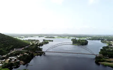

The reservoir, not the whole Volta Basin
This record covers the water body upstream of Akosombo Dam. It excludes the lower Volta River, the smaller Kpong Reservoir downstream, and the approximately 400,000-km² international Volta drainage basin as a whole. The lake lies entirely inside Ghana even though much of the water reaching it originated in Burkina Faso, Togo, Benin, Côte d'Ivoire, or Mali.[4]
VRA dates original dam construction to 1961–65; FAO's historical account says filling began in 1964. The two dates describe different stages of the project, so “created in 1964” and “Akosombo Dam, 1965” should not be read as contradictory completion dates.[1][3]
Before inundation, the Black and White Volta met within the area now covered by the reservoir and continued south as the Volta. The present lake has submerged that confluence and long reaches of each tributary valley. Its only river outlet is the Volta released through Akosombo's turbines or spillways.[2][3]
Four hundred kilometres along a branching axis
Both VRA and the older FAO inventory give a lake length of about 400 km. That is a reservoir-axis measurement, not the straight width of one open basin. From Akosombo in the south, the main water corridor broadens northward through central Ghana, divides around drowned interfluves, and reaches the northern river arms. The Black Volta approaches from the northwest, the White Volta from the north, and the Oti—called the Pendjari upstream—enters the northeastern side after flowing from Benin through Togo.[1][3][4]
The 1972 inventory bounded the reservoir at approximately 6°15′–9°00′ N and 1°00′ W–0°15′ E and reported a maximum width of 23.8 km. These are useful map limits for an irregular water body, not coordinates for a single point. At the southern end, the arms converge into the former Volta channel and then narrow toward Akosombo gorge.[2][3]
Black Volta arm
Water arrives from a basin shared principally by Burkina Faso, Côte d'Ivoire, and Ghana.
White Volta arm
The former White–Black Volta junction lies beneath the reservoir rather than at a visible modern river confluence.
Oti arm
The Oti/Pendjari connects the lake with the Atakora uplands of Benin and the river corridor through Togo.
Drowned relief, with dimensions tied to lake stage
Lake Volta is dendritic—tree-like in plan—because rising water occupied a pre-existing trunk channel and successively smaller tributary valleys. Low divides became peninsulas; higher remnants became islands; and shallow valley margins became bays and flats. The former channels contain the deeper water, while broad flooded surfaces respond most visibly when the operating level changes.[2]
The often-repeated dimensions are not one modern survey. VRA lists a nominal area of 8,502 km² and capacity of 148 × 1012 litres, equal to 148 km³. ILEC repeats those values and gives a legacy mean depth of 18.8 m and maximum depth of 75 m. By contrast, FAO's explicitly dated 1972 inventory reports 8,270 km², 19 m mean depth, and 74 m maximum depth. Differences in reservoir stage, bathymetric source, and boundary tracing are not fully documented, so the figures should remain attached to their source rather than merged into a supposedly exact present-day geometry.[1][2][3]
VRA's 68.8 m “hydraulic height” is the operating head at the dam, not the reservoir's maximum depth. Shoreline length is even more scale-sensitive: ILEC gives 4,800 km, while VRA gives 7,250 km. Without a common water level and mapping resolution, neither should be used as a timeless shoreline measurement.[1][2]
A young reservoir over an ancient sedimentary basin
Lake Volta is not a tectonic or volcanic lake. The water body is a twentieth-century impoundment laid across an older erosional landscape. Much of its broad central setting lies within Ghana's Voltaian geological basin, where consolidated sandstone, shale, mudstone, siltstone, limestone, and conglomerate units underlie subdued interior terrain. “Voltaian Basin” here names a rock and sedimentary structure; it is not interchangeable with the modern Volta River drainage basin.[4][6]
The Voltaian strata began accumulating after about 1,000 million years ago and record several marine and continental depositional settings. Those ancient rocks did not directly create the lake. River incision, weathering, and erosion shaped the valleys much later; damming then flooded the low ground. This sequence explains why the reservoir outline follows drainage geometry rather than a single fault-bounded depression.[6]
Near the southern outlet, the reservoir is funnelled toward Akosombo gorge instead of continuing across the broad interior. The dam occupies that confined reach, turning relief at the gorge into the fixed downstream control on the lake.[2]
Three major inflows and one regulated outlet
ILEC assigns 385,180 km² to the catchment feeding Lake Volta, whereas basin authorities commonly describe the entire Volta Basin as about 400,000 km². The larger number includes the lower basin below the reservoir as well as the upstream country. This is a boundary difference, not a change in the lake's size.[2][4]
The Black Volta, White Volta, and Oti supply the principal inflows. Long-term gauge records summarized in the Ghana transboundary assessment show low flows in the first half of the year, a sharp rise in the second half, and mean monthly peaks around September at Bui, Nawuni, and Saboba respectively. The Oti's relatively wet, steep sub-basin contributes disproportionately to inflow compared with its share of catchment area.[7]
Water leaves through hydroelectric generation or controlled spilling at Akosombo, then continues into the lower Volta and Kpong Reservoir before reaching the Gulf of Guinea. Direct rainfall adds water to the lake surface; evaporation removes it; and changing storage absorbs the difference between variable inflow and managed release. The lake is therefore open-draining but strongly regulated, not a terminal basin.[1][4]
River currents slow where tributary channels widen into reservoir arms. Suspended material then settles preferentially through river-to-lake transition zones, while finer particles can travel farther toward open water. The submerged valleys still guide flow, but dam storage interrupts the pre-dam continuity of water and sediment toward the lower Volta.[7]
Rainfall timing, evaporation, and operating decisions
The catchment crosses a strong north–south climate gradient. Seasonal movement of the Intertropical Convergence Zone produces one main wet season in the north, commonly peaking in September, and two rainfall peaks farther south. Moist monsoon flow dominates much of June–September; dry, dusty harmattan winds arrive from the northeast during the boreal winter. Lake level therefore reflects weather far beyond the Ghanaian shoreline.[5]
A satellite-gravity and altimetry study found that basin precipitation and Lake Volta storage vary together at interannual scales, including a rise during 2007–10 and decline during 2011–15. The result is a warning against treating any area or elevation as permanently current: rainfall history, evaporation, upstream runoff, power releases, and spillway operation all move the shoreline.[5]
VRA's published operating limits are 73.15 and 84.73 m. Its plant page also lists an observed low of 71.62 m on 21 July 2007 and high of 84.59 m on 8 November 2010. The page does not state the vertical datum, so these are best read as operator gauge elevations for comparison within the same series, not as interchangeable global-geodetic heights.[1]
Warm, shallow on average, and frequently mixed
Against its very large area, the legacy mean depth of about 19 m makes Lake Volta comparatively shallow on average. ILEC classifies it as polymictic, meaning that the water column mixes fully or nearly fully more than once in a typical year rather than maintaining one long, stable annual stratification. That basin-wide label does not imply identical conditions in every deep channel and sheltered arm.[2]
Wind stirring, tributary inflow, solar heating, and seasonal cooling act differently across the branching reservoir. Shallow margins can warm, cool, and shift shoreline quickly; deeper former channels have greater thermal and storage inertia. These contrasts are consequences of the drowned topography and changing stage, not separate lake basins.
From continental headwaters to the Atlantic
Read the system upstream to downstream: Black Volta, White Volta, and Oti headwaters gather runoff across six countries; their valleys enter the Ghana-only reservoir; stored water converges toward Akosombo; regulated discharge passes Kpong; and the lower Volta reaches the Gulf of Guinea. The reservoir is one central reach in this sequence, not a synonym for every part of it.[4]
Within the atlas, follow the river systems hub for the drainage connection or return to the lake hub. For contrast, Lake Victoria occupies a broad natural basin, while Lake Tanganyika fills deep fault-bounded troughs.
Sources and measurement notes
- Volta River Authority, Akosombo Hydro Plant (accessed 29 August 2026). Operator source for the dam and reservoir type, 1961–65 construction period, nominal 8,502-km² area, 148 × 1012-litre capacity, 400-km length, 68.8-m hydraulic head, operating limits, and dated high and low gauge elevations. The web table does not state survey dates for area/capacity or the vertical datum for elevations.
- International Lake Environment Committee Foundation, World Lake Database: Volta Lake (record derived from historical national and scientific submissions; accessed 29 August 2026). Source for dendritic form, Akosombo gorge, 8,502-km² catalog area, 148-km³ volume, 18.8-m mean and 75-m maximum depths, 385,180-km² upstream catchment, named islands, one river outlet, and polymictic classification.
- Food and Agriculture Organization of the United Nations, Source Book for the Inland Fishery Resources of Africa, Volume 2: Ghana (FAO Fisheries Circular 710.2, 1991), Lake Volta entry citing Welcomme's 1972 geographical data. Source for approximate coordinate limits, the dated 8,270-km² area, 74-m maximum and 19-m mean depths, 400-km length, 23.8-km maximum width, principal inflows, the submerged Black–White Volta junction, and 1964 impoundment context.
- Mul, M. et al., Water Resources Assessment of the Volta River Basin, International Water Management Institute Working Paper 166 (2015). Source for the six-country drainage-basin scope, four major sub-basins, direct lower-basin tributaries, Oti/Pendjari route, Lake Volta's position above the lower Volta, Kpong, and the sea, and basin-scale geology.
- Ni, S., Chen, J., Wilson, C. R., and Hu, X., “Long-Term Water Storage Changes of Lake Volta from GRACE and Satellite Altimetry and Connections with Regional Climate”, Remote Sensing 9, 842 (2017). Source for the ITCZ-controlled rainfall gradient, monsoon and harmattan seasons, satellite methods, precipitation–storage connection, and 2007–15 multi-year water-level behavior.
- Carney, J. N. et al., “Lithostratigraphy, sedimentation and evolution of the Volta Basin in Ghana”, Precambrian Research 183, 701–724 (2010), doi:10.1016/j.precamres.2010.08.012. Source for the age, stratigraphic setting, rock types, and depositional history of the Voltaian geological basin.
- GEF–Volta Project, Volta Basin Transboundary Diagnostic Analysis: National Report Ghana (2012), pp. 37–44. Source for tributary catchments, relative Oti contribution, seasonal gauge behavior at Bui, Nawuni, and Saboba, runoff variability, wet- and dry-season inflow, and suspended-sediment load summaries.