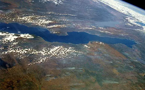

The lake, not the wider Tanganyika basin
This record covers the standing water body and its immediate basin margins. It does not use “Tanganyika” to mean the former territory, the Congolese province, or the entire drainage basin. The international boundaries cross the water: Burundi occupies the northern shore, Zambia the southern end, Tanzania most of the east, and the Democratic Republic of the Congo most of the west. Rwanda lies within the wider hydrographic basin through Lake Kivu and the Ruzizi River but has no Tanganyika shoreline.[1][5]
The UK Permanent Committee on Geographical Names recommends Lake Tanganyika in English and records French Lac Tanganika. Its 6°00′00″ S, 29°30′00″ E coordinate is a map-reference point, not a surveyed centroid, border point, or deepest-point position. FAO places the lake within about 3°20′–8°48′ S and 29°05′–31°15′ E; that rectangle is a useful extent, not a shoreline polygon.[1][2]
Spatially, the Ruzizi delta and Bujumbura–Uvira lowlands frame the north. Kigoma lies on the central Tanzanian shore, the Mahale Mountains rise beside the eastern-central lake, and Kalemie stands on the west beside the Lukuga outlet. The water narrows again toward the Mpulungu basin at the southern end. These named points orient the lake without confusing towns or national sectors with the physical feature.[4][5]
Large figures, but not false precision
Published length depends on how the curved end-to-end reach is generalized. FAO's project description gives 673 km but its adjoining characteristics table gives 650 km; a 2023 structural study describes the lake as approximately 645 km long. Because none defines identical endpoints or a measured route, this page uses “roughly 650–673 km” rather than presenting one value as survey-exact. The same FAO source gives a mean width of about 50 km.[2][4]
The headline 32,900 km² surface, 570 m mean depth, and 18,880 km³ volume form one internally consistent FAO compilation; the area excludes islands. The World Lake Database instead lists 32,000 km², 572 m, and 17,800 km³. Neither catalog entry documents a common survey date, lake level, shoreline resolution, or recalculation method, so the difference should not be read as measured modern shrinkage. This record keeps the explicitly defined FAO set and discloses the alternative rather than mixing values.[2][3]
Maximum depth is better tied to a mapped method: Shaban and colleagues' 2023 bathymetry, derived from seismic-reflection data, reaches 1,471 m. FAO rounds the southern deep to 1,470 m. The older 1,436 m figure previously shown here had no measurement definition and is not retained. The often printed 773 m surface elevation is also only a generalized reference; gauge and satellite records show that the water level changes seasonally and between years.[2][4][5]
Three main basins linked along the rift
Modern structural mapping divides the lake into the Ruzizi, Kigoma, and Marungu–Mpulungu main bathymetric basins from north to south, with smaller depressions within them. They are asymmetric half-grabens: blocks of crust lowered beside a major normal fault, so the deep side commonly lies near a faulted margin rather than at the centre of a symmetrical bowl. Nine mapped border faults and the accommodation zones between them transfer extension from one segment to the next.[4]
This segmentation explains why depth does not increase steadily southward. The older FAO sub-basin table places a 1,310 m deep in the Kigoma sector and the 1,470 m deep in the East-Marungu or Kipili sector, while intervening structural highs separate deep-water areas. At the margins, fault-block relief can rise abruptly: the Mahale Mountains include rift-shoulder uplifts more than 1,500 m above the lake surface.[2][4]
Ruzizi basin
The lake opens southward from the low Ruzizi delta into fault-bounded northern depressions.
Kigoma basin
A principal deep-water sector lies beside high eastern-central relief, including the Mahale margin.
Marungu–Mpulungu basin
The 1,471 m mapped maximum lies within the southern structural province, not at the lake's midpoint.
Extension reused older weaknesses in the crust
Tanganyika belongs to the magma-poor western branch of the East African Rift, between the Tanzania craton to the east and the Congo craton to the west. Here continental extension has been expressed mainly by normal faulting and subsidence rather than by a continuous belt of volcanoes. Aeromagnetic, gravity, and seismic data show that younger rift faults repeatedly followed much older Precambrian shear zones and metamorphic fabrics in the basement.[4]
As fault blocks subsided, rivers and the lake filled the new accommodation space with sediment. The mapped syn-rift fill reaches about 6 km beside the western border fault of the Marungu province. Border faults control the steep side of each half-graben; inherited basement highs and accommodation zones interrupt the trough, steer river entry, and separate depositional centres. The modern water body is therefore the surface expression of a much deeper rock-and-sediment basin.[4]
There is no securely dated single “birthday” for Lake Tanganyika. A widely repeated 9–12 million-year estimate extrapolates shallow-core sedimentation rates down to unsampled basin basement; other studies date different tectonic or volcanic events and produce different ages. The 2023 synthesis states that rift initiation remains unresolved because the basal fill has not been directly sampled. This page consequently describes Tanganyika as a long-lived active rift-lake system but does not rank it by age.[4]
Faulted coasts interrupted by deltas and mobile sand
Steep rift shoulders leave little coastal plain along many reaches, especially where a border fault approaches the shore. A 2000 FAO lakewide classification assigned 43% of shoreline substrate to rock, 31% to sand, 21% to mixed rock and sand, and 5% to marsh. Those categories are a dated regional inventory, not a permanent fine-scale coast map: river mouths build deltas and fans while waves move loose sediment alongshore.[2]
The low northern end is an important contrast to the cliffed margins. The Ruzizi enters through a broad delta beside the Bujumbura–Uvira plain, and the Malagarasi reaches the eastern shore through a wetland delta. Smaller steep catchments deliver shorter pulses of coarse and fine sediment directly from the rift shoulders; the Lufubu is an example near the southern basin.[8]
Local image sequences show that the shore is mobile even though the structural basin is not changing at the same visible rate. A World Bank study mapped a sand spit about 22 km south of Bujumbura growing roughly 150 m over ten years, and more than 30 ha of delta growth beside the Ntahangwa River between 2002 and 2016. These are site-specific examples influenced by sediment supply and shoreline works, not rates to apply around the entire lake.[5]
Rain, tributaries, evaporation, and a threshold outlet
The Ruzizi carries water south from Lake Kivu into Tanganyika's northern end. The Malagarasi drains a broad Tanzanian catchment to the eastern shore; the Lufubu enters the southern basin, while numerous short rivers descend the steep western and eastern margins.[6][8] Direct rain on 32,900 km² of open water is itself a major input. Because recent continuous gauges are sparse, the 2024 basin study modelled Ruzizi, Malagarasi, and Lukuga discharge rather than treating them as observed series; this page does not promote its model outputs as measured river flows.[6]
Water leaves mainly by evaporation and secondarily through the Lukuga on the western shore near Kalemie. The World Bank's 2017 synthesis estimated direct rainfall at about 900–1,000 mm per year, runoff as 430–950 mm of equivalent lake-level input, and lake evaporation at 1,500–1,700 mm per year. It placed Lukuga discharge at only 6–18% of total loss, but emphasized that component estimates are sparse and differ among water-balance studies.[5]
The Lukuga is not a constant-flow drain. Its discharge rises with lake level and can approach zero near the outlet threshold. The same report cites a historical rock-sill elevation of 772.7 m above sea level but warns that reliable recent measurements and a current stage–discharge rating curve were lacking. The river flows west to the Lualaba, the upper Congo River; Tanganyika is therefore an Atlantic-draining lake, not part of the Nile basin.[5][9]
A moving shoreline, not a fixed 773 m plane
Records synthesized through 2016 put the typical seasonal rise and fall at about 70–80 cm, with high water near the end of the October/November–May rainy season and low water near the end of the dry season in September or October. The same mixed gauge-and-satellite compilation placed most historical levels between about 773 and 776 m above sea level. It does not identify a modern vertical datum for every component, so those elevations are context rather than survey control.[5]
Longer wet or dry sequences move the lake beyond its regular annual cycle. Satellite altimetry and Sentinel-2 mapping in a 2024 study detected a marked rise in 2019–2020 and extensive inundation around the northern lowlands in 2020–2021, including Gatumba and the Ruzizi delta. That recent episode updates the 2017 report's earlier conclusion of no long-term trend through its observation window; the two findings refer to different periods and are not contradictory.[6]
Seasonal motion above water that never fully overturns
Tanganyika is meromictic: its whole water column does not mix from surface to floor during the annual cycle. Warm upper water overlies a cooler, denser deep layer, separated by a thermocline—a zone where temperature changes rapidly with depth. Seasonal exchange is concentrated in roughly the upper 150 m, while much of the deep water remains isolated and oxygen-poor.[7]
During the cool dry season, strong southeast winds blow along the lake's long axis. Wind stress moves surface water northward and tilts the thermocline upward in the south; cooling and evaporation further weaken southern stratification. A three-dimensional present-climate simulation moved the southern thermocline from about 75 m depth to the surface in August and September. When the winds relax, the tilted boundary oscillates back as an internal seiche—an underwater wave along the density boundary.[7]
This north–south circulation is a physical consequence of the lake's great length, sheltering relief, and seasonal wind field. The northern basin is more protected by mountains and generally mixes less deeply; the exposed south cools and mixes more strongly. “Tropical lake” therefore does not mean a uniform warm column or identical conditions from Bujumbura to Mpulungu.[7]
A Western Rift basin within the Congo watershed
Tanganyika lies south of Lake Kivu and north of Lake Mweru in the western rift-lake chain, but those neighboring lakes do not form one continuous trough or one simple downstream sequence. Kivu supplies Tanganyika through the Ruzizi; Mweru occupies a different upper Congo route through the Luapula and Luvua.
Tanganyika also contrasts with Lake Victoria, a much broader and shallower plateau basin. Follow the lake hub for standing-water comparisons, the terrain index for rift structure, or the Congo River record downstream from the Lukuga and Lualaba.
Sources and measurement notes
- UK Permanent Committee on Geographical Names, Burundi: Toponymic Factfile, edition 2 (August 2025), p. 5 (PDF p. 5; accessed 29 August 2026). Source for the recommended English name, French variant, international-lake scope, and 6° S, 29°30′ E map-reference coordinate. PCGN notes that it normally recommends conventional English names for international features.
- FAO/FINNIDA Lake Tanganyika Research Project, General Features, and FAO, Lake Tanganyika Regional Fisheries Programme (2000), pp. 23–24 (PDF pp. 40–41; both accessed 29 August 2026). Compiled sources for extent, surface elevation, length alternatives, mean width, island-exclusive surface area, volume, mean and rounded maximum depths, sub-basins, shoreline classes, country shares, and seasonal climate. These legacy measurements do not provide a shared modern survey date or datum.
- International Lake Environment Committee Foundation, World Lake Database: Lake Tanganyika (AFR-06) (database page accessed 29 August 2026). Source for the alternative 32,000 km² area, 572 m mean depth, 17,800 km³ volume, 1,900 km shoreline, and tectonic classification. The page does not state survey dates or measurement methods for reconciling these values with FAO's set.
- Shaban, S. N., Kolawole, F., and Scholz, C. A., The Deep Basin and Underlying Basement Structure of the Tanganyika Rift, Tectonics 42 (2023), e2022TC007726 (accessed 29 August 2026). Seismic-reflection, aeromagnetic, and gravity source for the 1,471 m bathymetric maximum, three principal basins, border faults and half-grabens, high relief, sediment thickness, inherited basement fabrics, magma-poor Western Rift setting, and unresolved initiation age.
- Serrat-Capdevila, A., Lajaunie, M. L., Bonzanigo, L., Figueira, P., and Bench, R., World Bank Water Global Practice, Port Access in the Lake Tanganyika: Key Challenges and Recommendations (final report submitted July 2017), especially pp. 3–15 (PDF pp. 6–18; accessed 29 August 2026). Mixed historical gauges, satellite estimates, local surveys, imagery, and field evidence for basin scope, the Lukuga threshold and data limitations, water-balance ranges, seasonal and interannual level behavior, and local shoreline sediment examples.
- Gbetkom, P. G., et al., Lake Tanganyika Basin Water Storage Variations from 2003–2021 for Water Balance and Flood Monitoring, Remote Sensing Applications: Society and Environment 34 (2024), 101182, doi:10.1016/j.rsase.2024.101182 (accessed 29 August 2026). Remote-sensing and model source for major rivers, discharge-data limitations, basin rainfall gradients, the 2019–2020 level rise, and mapped 2020–2021 flooding around the northern lowlands.
- Sterckx, K., et al., The Impact of Seasonal Variability and Climate Change on Lake Tanganyika's Hydrodynamics, Environmental Fluid Mechanics 23 (2023), 103–123 (accessed 29 August 2026). Open three-dimensional modelling study and literature synthesis for meromixis, the upper-150 m seasonal regime, southeast-wind forcing, thermocline tilt, southern cooling and mixing, northern shelter, and internal seiching. Future RCP 8.5 projections in that paper are not presented here as observations.
- Lake Tanganyika Authority Secretariat, Strategic Action Programme for the Protection of Biodiversity and Sustainable Management of Natural Resources in Lake Tanganyika and its Basin (2012), especially pp. 46–48 and Annex VI (PDF pp. 60–62 and 133; accessed 29 August 2026). Regional intergovernmental source for the Ruzizi, Malagarasi, and Lufubu delta settings and for the distinction between the lake and its transboundary basin. Its approximate geological chronology is not used as a directly dated age for the modern lake.
- Tourian, M. J., et al., Current Availability and Distribution of Congo Basin's Freshwater Resources, Communications Earth & Environment 4 (2023), 174 (accessed 29 August 2026). Satellite-altimetry and gravimetry study defining the Lualaba–Lukuga sub-basin and confirming that Tanganyika drains partly through the Lukuga at Kalemie into the Lualaba basin; it also demonstrates the lake's strong control on Lukuga discharge.