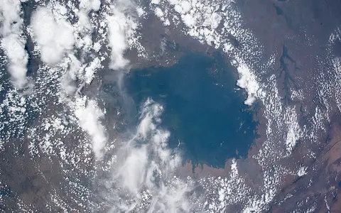

One lake across three states
The United Kingdom Permanent Committee on Geographical Names recommends Lake Victoria and records Nyanza-Viktoria as a Swahili variant. Its 1°S, 33°E coordinate is a map reference for the feature, not a surveyed center, shoreline point, or boundary marker. The water extends from roughly 0.5°N to 3°S, so part of the lake lies north of the equator and most lies south of it. [1][4]
Tanzania borders the southern lake, Uganda the north and northwest, and Kenya the northeastern sector. The drainage basin is wider than the shoreline states: it also reaches Rwanda and Burundi through the Kagera system. “Lake Victoria Basin” can therefore mean the lake plus its land catchment, whereas the figures on this page labelled surface area describe open water within a mapped shoreline. [5]
Gulfs and islands break up a broad plateau basin
The open lake is more than 375 km across at its maximum diameter, but its edge is deeply indented. Winam Gulf projects eastward into Kenya near Kisumu. The southern shore opens into Mwanza Gulf and Speke Gulf in Tanzania, while the Ssese island group divides waters off Uganda's northwestern shore. Ukerewe, south of Speke Gulf, is among the largest islands; other mapped groups and islands include Buvuma, Kome, Ukara, Lolui, and Mfangano.[2][3]
These names describe physical parts of the same lake, not separate basins. Bays and channels can have much shorter water-exchange paths and larger river or wetland influence than the open center. They also lengthen the mapped shore, so shoreline totals depend strongly on image resolution and on whether small islands, reeds, and narrow inlets are traced.
Rift-shoulder uplift reversed older rivers
Victoria differs from the long, fault-bounded troughs occupied by Lakes Tanganyika and Malawi. It lies in a localized sag on the plateau between the two principal rift branches. Continued uplift along the Western Rift shoulder tilted the older landscape, obstructed streams that had flowed westward, and reversed drainage into a broad back-ponded depression. Buried river channels can still be traced beneath the lake floor.[2][4]
A geological synthesis places formation of the precursor lake within roughly the last 400,000 years, but that is not the age of the present water or shoreline. Sediment cores and seismic surfaces show repeated contractions and at least one basin-wide desiccation around 17,000–16,000 years ago. The lake then refilled, stood near its modern depth by about 13,000 years ago, and resumed overflow toward the Victoria Nile by the beginning of the Holocene.[4]
Area, depth, and elevation need a survey date
The HRBS-GLWNB survey combined 17,958,859 corrected echo soundings collected in 2017–2020 with a Landsat 8 shoreline. Earlier soundings were adjusted to the 2020 water surface. Its derived Lake Victoria values are 66,792.9 km² of surface area, 39.77 m mean depth, 74.12 m for the deepest collected sounding, and 2,302.19 km³ of water. The corresponding 2020 survey surface was 1,136.92 m in the EGM2008 geoid model.[2]
The World Lake Database instead lists 68,800 km², 40 m mean depth, 84 m maximum depth, and 2,750 km³. Its record compiles older sources and does not attach those dimensions to one shoreline date or sounding datum.[3] The difference between 74.12 m and 84 m is therefore reported here as a difference between a modern deepest collected sounding and a legacy catalogue maximum—not as proof that ten metres of lake floor or water disappeared.
About 66,793 km²
The boundary was digitized from Landsat imagery, so it describes a mapped water extent.
39.77 m mean
Mean depth and volume were calculated from a triangulated bathymetric surface.
1,136.92 m EGM2008
Jason-3 altimetry defined the 2020 surface used as the sounding datum.
Rain dominates input; evaporation dominates loss
About 25 major rivers enter the lake. The Kagera approaches from the west after draining highlands and wetlands in Rwanda, Burundi, Tanzania, and Uganda; a hydrological synthesis estimates that it supplies about 30% of total river inflow. Nzoia, Yala, Sondu, and Awach Kaboun descend toward the northeastern lake from wetter, steeper catchments, while the Mara and Mbalangeti approach from the southeast. [5]
Rivers are not the largest water source. For the 1993–2014 observational model, precipitation directly on the lake supplied 76% of total input and tributaries 24%; evaporation removed 77% of output and the Victoria Nile 23%. Those percentages are period-specific model results, not permanent ratios. They show why errors in over-lake rainfall and evaporation matter so much for a lake whose water surface occupies a large fraction of its drainage system.[5]
The only surface outlet is at Jinja, Uganda, where water enters the Victoria Nile and is regulated by the Nalubaale–Kiira hydropower complex. The river passes through Lake Kyoga before continuing to Lake Albert; north of Lake Albert the same drainage continues as the Albert Nile and then the White Nile. Outlet regulation means modern lake level reflects both climate and managed discharge. [3][5]
A shallow bowl responds to rain, release, and wind
In the 1993–2014 model and altimetry record, the average seasonal lake-level range was less than 0.4 m, while the largest interannual difference approached 2.5 m. The lake rose during the two rainy seasons and generally lost water during drier months. The 2004–2005 decline illustrates the mixed control: the model attributed about 52% of the fall to basin drought and 48% to releases above the agreed operating curve.[5]
The surface is not a perfectly level plane at every moment. Across a fetch of hundreds of kilometres, wind setup can push water toward one shore and basin-scale seiches—standing oscillations of the water surface—can shift level from side to side. The modern survey therefore used a Jason-3 altimeter track across the lake rather than treating one nearshore gauge as representative of the entire surface. [2]
Two rainy seasons and one main mixing season
Seasonal movement of the tropical rain belt helps produce long rains in March–May and a second rainfall maximum in October–December. Rain over the lake peaks mainly at night and in the morning because the warm water, cooler nighttime land, prevailing easterlies, and surrounding high ground organize convergent airflow over the basin. Shore gauges alone consequently under-sample precipitation over open water. [5][7]
Lake Victoria is commonly classified as warm monomictic: it develops seasonal thermal layering but has one principal period of deep mixing each year rather than freezing and overturning twice. Stronger winds after the long rains tilt the thermocline—the zone of rapid temperature change—drive cross-basin exchange, and erode seasonal stratification. Inshore water can remain 0.2–1.5°C warmer than offshore water, so local circulation differs between sheltered bays and the open lake.[3][6]
Sources and measurement notes
- United Kingdom Permanent Committee on Geographical Names, Kenya: Toponymic Factfile, p. 6 (updated January 2026; accessed 29 August 2026). Source for the recommended name, Swahili variant, feature type, and approximate 1°S, 33°E map reference.
- Hamilton, S. E. et al., “High-resolution bathymetries and shorelines for the Great Lakes of the White Nile basin”, Scientific Data 9, 642 (2022). Source for the inter-rift depression, maximum diameter, 2017–2020 sounding method, 2020–2021 Landsat shoreline scenes, 66,792.9 km² area, 39.77 m mean depth, 74.12 m deepest sounding, 2,302.19 km³ volume, and 1,136.92 m EGM2008 survey surface. The paper aligns all depths to the 2020 level and labels 74.12 m as the deepest collected sounding rather than an immutable lake maximum.
- International Lake Environment Committee Foundation, World Lake Database: Lake Victoria (archived lake record; accessed 29 August 2026). Source for the legacy 68,800 km² area, 40 m mean depth, 84 m maximum depth, 2,750 km³ volume, named principal islands, single Victoria Nile outlet, and monomictic classification. The record compiles older sources and does not state a common survey date or datum for its morphometric fields.
- Tryon, C. A. et al., “The Pleistocene prehistory of the Lake Victoria basin”, Quaternary International 404(B), 100–114 (2016). Source for the equatorial extent, uplift-and-back-ponding origin, buried river channels, approximate formation interval, late-Pleistocene desiccation, subsequent refilling, and restoration of overflow. Geological ages are rounded because they summarize dated cores and regional interpretations rather than one formation event.
- Vanderkelen, I., van Lipzig, N. P. M., and Thiery, W., “Modelling the water balance of Lake Victoria (East Africa) – Part 1: Observational analysis”, Hydrology and Earth System Sciences 22, 5509–5525 (2018). Source for the five-country drainage basin, tributary geography, 1993–2014 input and output shares, rainfall seasons, nocturnal precipitation, lake-level variability, regulated Jinja outflow, and attribution of the 2004–2005 decline.
- MacIntyre, S. et al., “Stratification and horizontal exchange in Lake Victoria, East Africa”, Limnology and Oceanography 59(6), 1805–1838 (2014). Source for seasonal stratification loss, wind-driven cross-basin exchange, thermocline tilting, internal-wave mixing, and the measured inshore–offshore temperature contrast.
- Woodhams, B. J. et al., “Aircraft observations and sub-km modelling of the lake–land breeze circulation over Lake Victoria”, Quarterly Journal of the Royal Meteorological Society 148(743), 1109–1134 (2022). Source for the observed eastern-shore lake and land breezes, nocturnal low-level convergence, moisture lifting over the lake, prevailing-easterly interaction, and topographic reinforcement of the diurnal circulation.