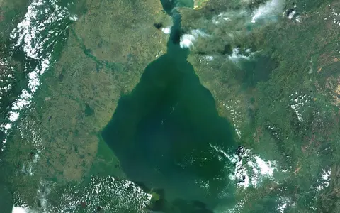

The lake within a larger estuarine system
The U.S. National Geospatial-Intelligence Agency lists Lago de Maracaibo as the primary geographic name and records “Lake Maracaibo” and “Maracaibo Lagoon” among its variants. This English-language record uses the documented name Lake Maracaibo, while “estuarine” describes how the water behaves. The marine connection does not erase the named feature, but it does make closed-lake comparisons misleading.[1][5]
This page uses Lake Maracaibo for the broad water body south of the strait. The connected system continues north through the Strait of Maracaibo, El Tablazo Bay, three narrow inlets, the Gulf of Venezuela, and ultimately the Caribbean Sea. The drainage basin also reaches into Colombia through the Catatumbo system; that transboundary watershed is much larger than the Venezuelan lake surface.[3][5]
The distinction is measurable. A 1978 Venezuelan ministry estimate reproduced by FAO gives 89,756 km² for the drainage basin, including 76,650 km² in Venezuela, whereas a 2017 USGS assessment maps a roughly 58,000 km² Maracaibo Basin Province bounded geologically rather than hydrologically. Neither number is the area of the lake.[3][7]
A wide shallow lake, then a constricted outlet
For its 2003 circulation model and field analysis, Laval and colleagues described the lake as about 150 km north–south and 110 km east–west, with a 12,000 km² surface. Their lake floor was comparatively flat: about 28 m across much of the basin, 26 m mean depth, and 34 m maximum depth. These are study-scale descriptors, not a new hydrographic chart, and the paper gives no vertical datum for the maximum.[4]
The ILEC catalog instead gives 13,010 km² and 280 km³, without publishing a shoreline epoch or calculation method on the record. An older FAO profile gives 12,000 km², 25 m mean depth, and 35 m maximum. The small depth difference is compatible with rounding or source choice; the approximately 1,000 km² area spread is more likely to reflect different mapped water limits or editions. Because the source records do not define those boundaries, this page keeps the figures attached to their sources rather than averaging them.[2][3][4]
North of the open lake, the same 2003 study measured the Strait of Maracaibo as 40 km long, 6 km wide at its narrowest, and 7.7 km in average width. The natural route shoaled from about 15 m at the lake end to 6 m at El Tablazo Bay; its maintained shipping lane was then 14 m deep. El Tablazo itself was described as a roughly 20 by 30 km, barrier-enclosed shallow bay. These dimensions belong to the dated study and should not be read as current navigation specifications.[4][5]
Ancient structure beneath a much younger water surface
The shallow present lake overlies a structurally complex sedimentary basin. A seismic interpretation published in 1996 traces several superposed stages: Jurassic extension formed rift grabens; broad subsidence accompanied Cretaceous passive-margin sedimentation; and interaction with the Caribbean plate changed the area into a foreland basin during Paleocene–Eocene time. Later compression, normal faulting, and block rotation reworked the older structure.[6]
In plain terms, the visible water is not one ancient fault cavity preserved unchanged. Tectonic subsidence created and repeatedly deformed the low area, surrounding uplands supplied sediment, and coastal processes maintained the northern lagoon-and-barrier connection. ILEC therefore classifies the lake's origin with both “tectonic (downwarp)” and “coastal (lagoon)” components. Claims assigning one exact multimillion-year “age” to the modern lake confuse the older basin history with the present shoreline and are omitted here.[2][6]
Rift, then foreland basin
Older extensional faults were overprinted as Caribbean–South American convergence changed the stress regime.
Broad floor near 28 m
The hydrodynamic study generalized a comparatively flat lake floor rather than steep deep-water basins.
Bars, bay, and inlets
Barrier bars and islands enclose El Tablazo Bay between the strait and the Gulf of Venezuela.
Mountain runoff above, marine underflow below
The main inflows named in the FAO profile are the Catatumbo, Santa Ana, Escalante, and Chama. A 2009 tributary study also sampled the Limón, Palmar, Motatán, Misoa, Machango, and Pueblo Viejo systems; together those ten rivers were estimated to supply 80% of lake freshwater, with the Catatumbo alone contributing 60%. The Catatumbo rises in Colombia and reaches the southwestern lake, making the watershed transboundary even though the named lake is in Venezuela.[3][8][9]
Laval and colleagues used an annual-average freshwater input of about 1,600 m³/s from 30 rivers, based on a 1994 engineering compilation. They separated a wetter May–November period from a drier December–April period and cautioned that input varies between years. The number is therefore a model forcing and historical basin average, not a current gauged discharge at one river or date.[4]
Fresh surface water generally escapes north, but salt does not simply advance as a uniform front. Tidal action draws Gulf water into El Tablazo Bay and the strait, where it mixes with lake outflow. Denser brackish water can then enter the lake along the bottom and form a saline hypolimnion, or lower layer; salt is mixed upward into the lighter epilimnion, or upper layer. Current-meter work found lake tidal amplitudes below 3 cm at the analysed frequency bands, even while tides, runoff, and wind produced important current reversals and mixing in the narrow passage.[5]
Two rainy peaks and a nocturnal lightning maximum
Hydrographic observations describe two precipitation maxima over the basin, the larger in October–November and a second in April–May, with minima in February–March and July–August. Northeasterly trade winds are strongest during December–April; daily land–sea and lake-breeze circulations become more prominent when those trades weaken between May and November. These shifts change river outflow and the mixing balance in the estuarine passage.[5]
A 16-year Tropical Rainfall Measuring Mission Lightning Imaging Sensor climatology, gridded at 0.1°, placed its top-ranked global flash-density pixel over the lake at 9.75° N, 71.65° W: 233 flashes km⁻² yr⁻¹. The study estimated lightning on 297 days per year, with most activity at night and the strongest seasonal peak from August to November. Those are 1998–2013 satellite-climatology results for a defined grid and ranking method, not a permanent record for every point on the lake.[9]
The same study linked the nocturnal maximum to warm lake water, moisture, and converging mountain–valley, land–lake, and sea-breeze flows. During the day, warmer land favors divergence and subsidence over the water; after dark, the land and mountain slopes cool faster, directing low-level flow toward the lake. The Catatumbo lightning pattern is consequently a coupled relief–water–atmosphere process, not lightning generated by the Catatumbo River itself.[9]
From Andean drainage to the Caribbean
Lake Maracaibo gathers runoff from the Sierra de Perijá, the Cordillera de Mérida, and Colombian headwaters, then passes the combined freshwater north through a coastal estuary. That connected route makes the lake an Atlantic-draining water body despite its inland-looking planform. It contrasts with terminal basins such as the Caspian Sea and Lake Balkhash, which have no surface outlet to the ocean.
Within the atlas, the lake belongs in the lake hub; the Catatumbo-centered drainage belongs with the river systems; and the structural low, mountain margins, shallow floor, barriers, and alluvial shores connect to the terrain index. Those links preserve the difference between the named water body and the larger systems that shape it.
Sources and measurement notes
- U.S. National Geospatial-Intelligence Agency, Lago de Maracaibo, Geographic Names Server feature 4188224 (accessed 29 August 2026). Source for the primary Spanish name, recorded English and lagoon variants, feature class, and 9°48′57″ N, 71°33′24″ W reference point. A gazetteer point identifies the feature; it is not a surveyed centroid or extent.
- International Lake Environment Committee Foundation, Lake Maracaibo SAM-202, World Lake Database (accessed 29 August 2026). Source for the 13,010 km² catalog surface, 280 km³ catalog volume, and combined tectonic-downwarp/coastal-lagoon origin. The record supplies no shoreline epoch, datum, or calculation method, so its values are not merged with study-specific dimensions.
- Food and Agriculture Organization of the United Nations, The Inland Waters of Latin America: Maracaibo (Lake) (online edition accessed 29 August 2026). Source for the historical 12,000 km² surface, 25 m mean and 35 m maximum depths, 160 by 120 km dimensions, named major inflows, and 89,756 km² drainage estimate. The basin area is attributed there to Venezuela's Ministry of Agriculture and Livestock (1978); the profile's navigation statement is obsolete and is not used.
- Laval, B., Imberger, J., and Findikakis, A. N., “Mass transport between a semienclosed basin and the ocean: Maracaibo System”, Journal of Geophysical Research: Oceans 108(C7), 3234 (2003). Source for the 150 by 110 km study dimensions, 12,000 km² study surface, 26 m mean and 34 m maximum depth descriptors, 40 km strait dimensions, 20 by 30 km El Tablazo dimensions, approximately 1,600 m³/s historical mean river input, seasonal runoff grouping, and modelled salt exchange. The cited 14 m shipping-lane depth describes the study period, not present navigation clearance.
- Antoranz, A. M., Pelegrí, J. L., and Masciángioli, P., “Tidal currents and mixing in the Lake Maracaibo estuarine system”, Scientia Marina 65(S1), 155–166 (2001). Source for the lake–strait–bay–gulf system, barrier bars and islands, partly mixed estuary classification, upper and lower salinity layers, tide–wind–runoff forcing, less-than-3-cm lake tidal amplitudes, and observed seasonal precipitation and wind pattern.
- Bueno R., E., “Superposed structural styles of the Maracaibo Basin, Venezuela”, Third International Symposium on Andean Geodynamics, Saint-Malo, pp. 299–302 (1996). Source for the basin's position between the Mérida Andes and Sierra de Perijá and the sequence of Jurassic rifting, Cretaceous passive-margin subsidence, Paleocene–Eocene foreland development, and overprinting fault styles.
- U.S. Geological Survey, Assessment of Continuous Oil and Gas Resources of the Maracaibo Basin Province of Venezuela and Colombia, 2016, Fact Sheet 2017–3011 (2017). Source for the approximately 58,000 km² geologic-province extent between the Sierra de Perijá and Cordillera de Mérida and its general northern boundary at the Oca–Ancón fault. This petroleum-assessment boundary is not the lake's drainage basin.
- Rivas, Z. et al., “Total Nitrogen and Phosphorus From Tributary Rivers to the Lake of Maracaibo System, Venezuela”, Interciencia 34(5), 308–314 (2009). Source for the ten named tributary basins, their estimated 80% share of freshwater input, and the Catatumbo's estimated 60% share. These proportions describe the study compilation, not a continuously gauged modern water budget.
- Albrecht, R. I. et al., “Where Are the Lightning Hotspots on Earth?”, Bulletin of the American Meteorological Society 97(11), 2051–2068 (2016). Source for the 16-year TRMM-LIS 0.1° climatology, 9.75° N, 71.65° W top-ranked pixel, 233 flashes km⁻² yr⁻¹, 297 lightning days per year, seasonal and nocturnal timing, 28–31°C cited water temperatures, and the terrain–breeze convergence mechanism. The record applies to that satellite dataset and ranking method.