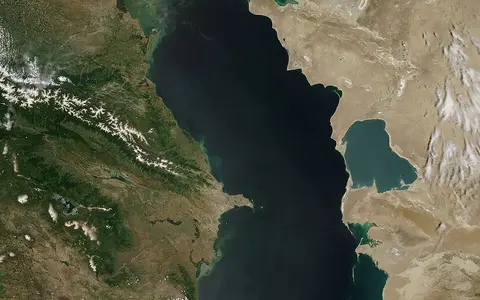

One conventional name across five shores
The UK Permanent Committee on Geographical Names records Caspian Sea as the English conventional name for the international feature and gives the Russian form Kaspiyskoye more. Regional forms also include Persian Darya-ye-Khazar, Azerbaijani Khezer Denizi, Turkmen Kaspi Denzi, and Kazakh Kaspi Tenizi in the romanization used by the 2010 Caspian Sea Encyclopedia.[1][6] These are names for the transboundary water body, not for one state's sector or for the wider Caspian drainage basin.
“Sea” describes its scale, brackish water, waves, and deep internal basins; “lake” describes its closed hydrology. Endorheic means that surface drainage terminates inside a continental basin. The Caspian has no natural connection to the world ocean, so global ocean tides and eustatic sea-level change do not set its level. Rivers, direct precipitation, evaporation, and exchange with Kara-Bogaz-Gol do. [5][6]
A north–south depression between plains and mountains
The water body extends from about 36.5° to 47.2°N and 46.5° to 54.1°E. The Volga–Ural lowlands and Caspian Depression meet its broad northern shelf; the Caucasus and their foothills approach the western shore; the Alborz backs the narrow Iranian coast; and the Ustyurt Plateau and Karakum drylands frame much of the east. Azerbaijan borders the west, Iran the south, Turkmenistan the east, Kazakhstan the northeast, and Russia the northwest.[3][6]
Published dimensions depend on the shoreline and measuring axis. The 2019 Tehran Convention report gives 1,030 km north–south and 435 km east–west, while a 2025 geospatial synthesis rounds the present extent to about 1,150 by 450 km.[2][7] Area is less stable still: reputable syntheses report about 371,000, 387,000, and 392,600 km². They do not provide a common survey date, shoreline polygon, or consistent statement about marginal waters, so this page does not merge them into one precise figure. The stat card uses the rounded 2025 value and treats it as an approximate footprint, not a permanent area.[2][4][7]
A Paratethys remnant over unlike crustal basins
The modern Caspian and Black Sea basins are remnants of Paratethys, an epicontinental water body that developed north of the Alpine–Caucasus–Himalayan mountain belt. A 2019 stratigraphic review places the Caspian's isolation from the Black Sea in the earliest Pliocene. Since then, repeated transgressions (advancing water) and regressions (retreating water) have shifted its shoreline by tens to hundreds of metres vertically; the broad northern plain amplified each vertical change into a large horizontal migration.[4]
The three water basins do not overlie one uniform geological depression. Beneath the Southern Caspian, seismic studies identify 15–25 km of sediment over unusually thin, high-velocity crust. Researchers interpret that basement either as unusually thick oceanic crust or as thinned continental crust, and the distinction remains unresolved. Around it, active deformation is concentrated in the mountain belts and the Apsheron–Balkhan sill zone as Arabia converges with Eurasia.[5] This tectonic setting helps explain why the southern depression is far deeper than the northern shelf.
Three basins divided by two thresholds
The Mangyshlak Threshold, between Chechen Island and the Tyub-Karagan area, separates the Northern and Middle Caspian. Farther south, the Apsheron (Absheron) Sill crosses between the Apsheron region of Azerbaijan and western Turkmenistan; water above its deepest passage is about 180 m deep. It divides the Middle Caspian's Derbent depression from the deeper Southern Caspian.[3][6]
A peer-reviewed morphometric summary gives mean depths of about 10 m in the north, 200 m in the middle, and 350 m in the south; maximum depths are about 25, 788, and 1,025 m respectively. The western slopes of the two deep basins are steeper than their eastern slopes.[3] These are depths below the water surface in the cited bathymetric summary, not seabed elevations tied to a named vertical datum; each changes slightly as the lake surface moves. The northern mean varies by source—one 2019 regional report gives 4.4 m and a 2025 synthesis about 5 m—because this low-gradient shelf changes area and volume as the water level moves.[2][7]
Deltaic shelf
Volga and Ural water spreads across shoals, distributaries, islands, and a floor averaging only about 5–10 m deep.
Derbent depression
Beyond the Mangyshlak shelf break, the basin averages about 200 m and reaches 788 m.
Deep tectonic basin
South of the Apsheron Sill, the basin averages about 350 m and contains the 1,025 m maximum.
Volga inflow against evaporation
More than 130 rivers enter the Caspian, but their distribution is strongly one-sided. The Volga enters through its delta at the northwest corner and supplies about 80% of long-term surface runoff. The Ural also enters the Northern Caspian; the Terek, Sulak, Samur, and Kura drain the western mountains and forelands, while smaller Iranian rivers reach the south. The arid eastern shore supplies almost no permanent river runoff.[2][6]
A published 1900–1990 mean balance, in cubic kilometres per year, assigns about 300 to river runoff, 77 to precipitation on the sea, and 4 to groundwater, against 377 lost by surface evaporation and 13 flowing into Kara-Bogaz-Gol.[6] These rounded long-period estimates describe different fluxes, not a current annual budget, and they do not close exactly when summed. Kara-Bogaz-Gol is a shallow, strongly evaporative lagoon east of the main sea, joined by a narrow strait; it is an internal terminal sink, not an outlet to the ocean. The strait was blocked in 1980 and reopened in 1992, so its exchange is also not a timeless constant.[6]
Freshwater plume above brackish deep basins
Caspian water is anomalohaline—its dissolved-salt mixture and concentration differ from normal ocean water—and is usually described more simply as brackish. The 2019 regional report gives an average salinity of 12.7 g/L, with most open water around 12.6–13.2 g/L but the Northern Caspian ranging roughly from 1 to 8 g/L under river influence.[2] A single “Caspian salinity” therefore hides the strong plume and mixing gradient south of the Volga delta.
Wind and density differences circulate water through the deeper basins. Winter cooling makes water denser in the north and northeastern Middle Caspian; part sinks, fills the middle depression, and can overflow the Apsheron Sill into the south. Observations and modelling indicate that this exchange helps ventilate deep southern water, with an estimated flushing timescale of about 15–20 years rather than an annual replacement.[3]
A moving shoreline controlled by a continental water budget
The sea crosses a cold continental north, a desert east, and warmer mountain-backed western and southern margins. The Northern Caspian commonly freezes in winter, while open-water evaporation is greatest in the warm season. Seasonal level is usually lowest in winter and rises after the Volga's spring flood. Climate far upstream therefore matters as much as weather over the water: precipitation and snowmelt across the East European Plain control most inflow, while heat and dry air control loss from the sea surface.[2][6]
Level change is neither monotonic nor spatially uniform at the shore. Satellite altimetry measured a mean fall of 6.07 ± 0.26 cm per year from April 2002 to April 2015, superimposed on an annual oscillation of 17.6 ± 1.4 cm; a separate 1979–2015 water-budget reconstruction attributed the reversal from the 1979–1995 rise to increased evaporation.[8] A 2025 synthesis reports that individual annual declines since 2020 have reached as much as 30 cm, but that short-period maximum must not be projected as a constant rate.[7]
Falling water exposes the greatest horizontal area on the gently sloping north and northeast shelf, lengthens delta channels, and separates lagoons and shoals from open water. The deep southern basin loses far less area for the same vertical fall. This relief-controlled contrast is why a changing level cannot be translated into one uniform retreat distance or a timeless shoreline length.[4][7]
Sources and measurement notes
- United Kingdom Permanent Committee on Geographical Names, Russia: Toponymic Factfile, p. 10 (July 2022, reviewed and updated 2025; accessed 29 August 2026). Source for the English conventional name, Russian Kaspiyskoye more, the five littoral states, feature type, and 42°00′N, 50°00′E map reference. The factfile does not identify that coordinate as a centroid.
- Interim Secretariat of the Tehran Convention, Caspian Sea: State of the Environment, Second Report (2019), pp. 13 and 31 (accessed 29 August 2026). Source for the nominal area and Baltic-system level, 1,030 km by 435 km dimensions, 1,025 m maximum and 208 m whole-sea mean depth, sub-basin proportions and northern mean depth, river runoff, salinity, and climate controls. The report is marked “draft”; its area is retained only as one published estimate, not as the stat-card value.
- Babagoli Matikolaei, J., Aliakbari Bidokhti, A., and Shiea, M., “Some aspects of the deep abyssal overflow between the middle and southern basins of the Caspian Sea”, Ocean Science 15, 459–476 (2019; accessed 29 August 2026). Source for geographic bounds, three-basin mean and maximum depths, the 180 m Apsheron Sill passage, asymmetric deep-basin slopes, density-driven overflow, and the modelled 15–20-year southern-basin flushing time.
- Krijgsman, W. et al., “Quaternary time scales for the Pontocaspian domain: Interbasinal connectivity and faunal evolution”, Earth-Science Reviews 188, 1–40 (2019; accessed 29 August 2026). Source for the Paratethys setting, earliest-Pliocene isolation, repeated transgressions and regressions, 3.5-million-km² modern catchment, three-basin volume contrast, and the approximately 371,000 km² area estimate at a stated level near −27 m. The area conflicts with other syntheses whose shoreline definitions are not harmonized.
- Jackson, J. et al., “Active tectonics of the South Caspian Basin”, Geophysical Journal International 148(2), 214–245 (2002; accessed 29 August 2026). Source for sediment thickness, thin high-velocity crust, competing oceanic-versus-continental basement interpretations, and active deformation around the South Caspian block.
- Zonn, I. S., Kostianoy, A. G., Kosarev, A. N., and Glantz, M. H., The Caspian Sea Encyclopedia (Springer, 2010), entries “Caspian Sea,” “Kara-Bogaz-Gol Strait,” and “Water Balance of the Caspian Sea” (accessed 29 August 2026). Source for regional name forms, shore setting, basin boundaries, river distribution, 1900–1990 mean water-budget components, seasonal level, and Kara-Bogaz-Gol connection history. Its older nominal dimensions are not used as current measurements.
- Court, R. et al., “Rapid decline of Caspian Sea level threatens ecosystem integrity, biodiversity protection, and human infrastructure”, Communications Earth & Environment 6, article 261 (2025; accessed 29 August 2026). Source for the rounded 1,150 km by 450 km extent and 387,000 km² area, bathymetric reference at −27.5 m relative to global mean sea level, twentieth-century level sequence, and reported post-2020 annual declines. Its area is a synthesis value, not a dated cadastral shoreline survey.
- Chen, J. L. et al., “Long-term Caspian Sea level change”, Geophysical Research Letters 44(13), 6993–7001 (2017), together with Chen, J. L. et al., “Long-term and seasonal Caspian Sea level change from satellite gravity and altimeter measurements”, Journal of Geophysical Research: Solid Earth 122, 2274–2290 (2017). Sources for the 1979–2015 water-budget reconstruction, evaporation attribution, April 2002–April 2015 altimetric trend of −6.07 ± 0.26 cm/year, and 17.6 ± 1.4 cm seasonal amplitude. These rates describe stated observation windows, not a permanent future trend.