
A mountain system, not the wider Caucasus region
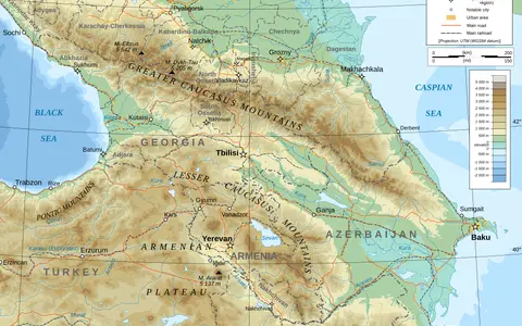
Caucasus Mountains is the clearest English name for the physical feature; shortened Caucasus can also mean the much wider historical and political region. The northern belt is the Greater Caucasus, also rendered Great Caucasus or Caucasus Major in some publications. The southern belt is the Lesser Caucasus, or Caucasus Minor. This page covers those two mountain belts and the physical corridor between them. It does not treat every adjoining plateau in eastern Anatolia or Iran, the North and South Caucasus administrative regions, or an Asia–Europe boundary convention as part of one measurable range.
No single surveyed polygon or authoritative centroid encloses the combined system. Dimensions must therefore name the belt being measured. The often-published figure of about 1,300 km applies to the Greater Caucasus from the Taman Peninsula at the Black Sea end to the Absheron Peninsula at the Caspian end. It is a rounded regional extent, not a cadastral boundary or a ridge-line survey. (Tielidze and others, 2020)
From the Taman Peninsula to the Caspian foreland
The Greater Caucasus trends west-northwest to east-southeast. Its western end rises inland from the Black Sea and Taman area; its central sector carries the greatest elevations; the eastern sector descends through the mountain plateaus and deeply cut valleys of Dagestan and Azerbaijan toward the Caspian. North of the range are the Azov–Kuban and Terek–Caspian forelands. South of it, the Rioni lowland opens west toward the Black Sea and the Kura basin opens east toward the Caspian, with the Dzirula and Likhi highlands forming the central divide. (Forte, Cowgill, and Whipple, 2014; NVE, 2017)
Mount Elbrus is a two-summit volcanic massif near the boundary between the western and central Greater Caucasus, about 10 km north of the main watershed rather than on it. The Smithsonian Global Volcanism Program lists its western summit at 5,642 m and 43.351° N, 42.442° E; the eastern summit is lower at 5,621 m. Elbrus is therefore a precisely located summit record, not a coordinate for the Caucasus as a whole. (Smithsonian Global Volcanism Program; Tielidze and others, 2020)
Collision assembled unlike mountain belts
Arabia continues to converge with Eurasia across a broad collision zone. In the Greater Caucasus, Cenozoic compression closed and inverted a former Mesozoic–Cenozoic back-arc basin: sedimentary rocks were folded and displaced on thrust faults, older basement was exhumed, and deformation spread into foreland fold-and-thrust belts. A thrust is a low-angle fault that places one slice of crust over another. The strongest phase of Greater Caucasus mountain building is young in geological terms, beginning about 5 million years ago, although the rocks record a much longer prehistory. (Forte, Cowgill, and Whipple, 2014)
The Lesser Caucasus is not simply a lower copy of the northern range. It preserves fragments of the former Tethyan realm, including volcanic-sedimentary arc rocks, continental blocks, and ophiolites—slices of oceanic crust and upper mantle emplaced onto a continent. These units were assembled through Late Cretaceous obduction and later collision, then affected by Eocene and Quaternary volcanism and continuing fault movement. The combined “Caucasus” label therefore joins belts with related plate-scale forcing but different rock assemblages and tectonic histories. (Danelian and others, 2011; Adamia and others, 2011)
Inverted back-arc basin
Closure, folding, thrusting, and basement exhumation built the principal high range.
Arc rocks and ophiolites
Tethyan oceanic fragments and volcanic-arc units record an older, multiphase history.
Rioni and Kura basins
Sediment-filled depressions separate the two topographic belts and continue to deform.
Asymmetric slopes, gorges, and glacial valleys
The Greater Caucasus is not a single wall of equal height. Swath-topography analysis shows marked changes in width, average slope, and structural style along the range. Much of the southern side is steeper than the northern side, while folds and thrusts extend beyond the high crest into the Kura, Terek–Sunzha, and Dagestan forelands. Rivers crossing these structures cut water gaps and steep gorges; elsewhere, longitudinal valleys follow weaker rocks or structural depressions. (Forte, Cowgill, and Whipple, 2014)
Ice has concentrated in the central high massifs and around Elbrus and Kazbegi–Jimara. Repeated Quaternary glaciation excavated cirques and trough-shaped valleys, while modern glaciers continue to deliver meltwater and sediment to steep headwater channels. Glacier distribution also follows the west-to-east moisture decline: western glaciers occur at lower mean elevations than those farther east, while the central high sector holds much of the remaining ice. (Tielidze and others, 2022)
The strongest gradient runs west to east
Moist westerly air is replenished over the Black Sea and loses water as it moves east across rising terrain. Orographic ascent—air forced upward by mountains—cools the air and promotes rain or snow; descending air is drier. Elevation and slope aspect create local contrasts, but in the Greater Caucasus the dominant regional precipitation gradient runs along the range rather than simply from one flank to the other.
A 2014 tectonic and geomorphic study using an interpolated mean-annual-precipitation surface mapped more than 200 cm per year near the Black Sea end and about 20 cm per year near the Caspian end. Those rounded values describe the climatology used in that study, not a 2026 station normal or a forecast. The physical consequence is robust: snow accumulation, glacier elevation, river runoff, vegetation cover, and erosion all change strongly from the humid west to the more continental east. (Forte, Cowgill, and Whipple, 2014)
Runoff reaches the Black, Azov, and Caspian seas
The Greater Caucasus divides several major drainage systems, but the divide is not everywhere the highest summit line. On the northwest side, the Kuban system reaches the Sea of Azov, part of the Black Sea drainage. The Terek crosses north through the central range and turns east to the Caspian; farther east the Sulak and Samur also descend toward the Caspian. On the southern side, the Enguri and Rioni drain west to the Black Sea, while the Aragvi, Alazani, Iori, and other tributaries enter the Kura system and ultimately the Caspian. (Encyclopaedia Iranica, physical geography; NVE, 2017)
Much of the Lesser Caucasus drains through the Kura–Aras network to the Caspian, whereas western catchments reach the Black Sea through systems including the Chorokhi. Snowmelt raises many mountain rivers in spring and early summer; glacier melt matters most in high glacierized headwaters later in the warm season. Rainstorms, snowmelt, unstable slopes, and abundant loose sediment can also generate debris-rich floods. These processes vary by catchment, so a flow figure from one river should not be generalized to the whole mountain system. (NVE, 2017)
A dated satellite inventory with stated uncertainty
A consistent inventory using Landsat, Sentinel-2, and SPOT imagery mapped 2,223 glaciers at least 0.01 km² in the Greater Caucasus around 2020. Their combined mapped area was 1,060.9 ± 33.6 km². The comparable 2000 inventory mapped 2,186 glaciers covering 1,381.5 ± 58.2 km². Total glacier area therefore fell by 320.6 ± 45.9 km², or 23.2 ± 3.8%, over the 20-year comparison. (Tielidze and others, 2022)
These are manually delineated surface areas, not ice volumes. The 2020 uncertainty was estimated with image- resolution buffers and repeat digitization; debris cover and deep shadow make some margins harder to identify. The glacier count did not fall in parallel with area, so count alone is not evidence of ice gain. The inventory applies to the Greater Caucasus in Russia, Georgia, and Azerbaijan and should not be presented as a timeless or whole-Caucasus glacier statistic.
Data sources and publications
- Smithsonian Institution, Global Volcanism Program. Elbrus, volcano no. 214010 (accessed 30 August 2026). Western summit coordinates, 5,642 m elevation, morphology, and eruptive record.
- Tielidze, L. G., Bolch, T., Wheate, R. D., Kutuzov, S. S., Lavrentiev, I. I., and Zemp, M. “Supra-glacial debris cover changes in the Greater Caucasus from 1986 to 2014,” The Cryosphere 14 (2020), 585–598. Greater Caucasus endpoints, approximate 1,300 km extent, sector divisions, and Elbrus position relative to the main divide.
- Tielidze, L. G., Nosenko, G. A., Khromova, T. E., and Paul, F. “Strong acceleration of glacier area loss in the Greater Caucasus between 2000 and 2020,” The Cryosphere 16 (2022), 489–504. Landsat, Sentinel-2, and SPOT inventory method; 0.01 km² cutoff; mapped areas, counts, changes, and uncertainties.
- Forte, A. M., Cowgill, E., and Whipple, K. X. “Transition from a singly vergent to doubly vergent wedge in a young orogen: The Greater Caucasus,” Tectonics 33 (2014), 2077–2101. Structural zones, young mountain building, foreland basins, topographic asymmetry, active convergence, and the mapped west–east climate gradient.
- Adamia, S., Zakariadze, G., Chkhotua, T., Sadradze, N., Tsereteli, N., Chabukiani, A., and Gventsadze, A. “Geology of the Caucasus: A Review,” Turkish Journal of Earth Sciences 20 (2011), 489–544. Regional Tethyan history, Arabia–Eurasia collision, Transcaucasian depression, and Neogene–Quaternary mountain building.
- Danelian, T., Sosson, M., Avagyan, A., and others. “A Brief Geological Outline of the Lesser Caucasus,” Annales de la Société Géologique du Nord 18 (2011), 65–75. South Armenian Block, Tethyan ophiolites, volcanic-sedimentary units, collision sequence, and later volcanism.
- Norwegian Water Resources and Energy Directorate. Hydrology of Georgia, Report 27 (2017). Physical setting of the Greater and Lesser Caucasus in Georgia; Black Sea and Caspian drainage; Rioni, Enguri, Terek, Kura, and Chorokhi connections.
- Thorez, P. Caucasus i. Physical Geography, Population, and Economy, Encyclopaedia Iranica V/1 (first published 2000; last updated 2015). Greater Caucasus relief, forelands, named northern and southern drainage, and the west–east moisture gradient. Modern glacier figures on that page are superseded here by the 2020 satellite inventory.