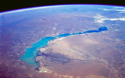

One lake, not the whole Balkhash–Alakol basin
“Lake Balkhash” is the English name used by the World Lake Database and recent research. “Balkash” is another romanized spelling in Kazakhstan's hydrometeorological literature; “Ile” similarly appears for the Ili River. This page uses Balkhash and Ili consistently while retaining source spellings in reference titles.[2][3][4]
The page covers the connected modern lake, including its western and eastern basins and the strait between them. It does not treat the much wider Balkhash–Alakol drainage region, the city of Balkhash, or Lake Alakol as parts of the water body. The Ramsar site named “Ili River Delta and South Lake Balkhash” is also a defined 976,630.3 ha wetland complex, not a boundary for the whole lake.[8]
The lake itself is inside Kazakhstan, but its water system is international: the upper Ili catchment extends into western China. The World Lake Database assigns 15% of the 413,000 km² wider basin to China, while the 2020 geological synthesis identifies only about 153,000 km² of that mapped basin as actively contributing water. The difference reflects drainage definition, not two measurements of the same boundary.[3][5]
An east–west lake between rocky and sandy shores
Lake Balkhash occupies the lowest part of the Balkhash–Alakol depression. Its northern side faces the low rocky country of central Kazakhstan; the southern catchments rise through dry alluvial plains toward the Zhetysu Alatau and Tien Shan source regions. The Ili crosses the Saryesik-Atyrau desert lowland before spreading into a large inland delta at the western lake.[4][5]
At a 342.5 m reference level, Kazhydromet literature gives a lake length of 605 km. Width changes from about 9–19 km in the narrow eastern reach to as much as 74 km in the west. These dimensions describe a specified lake stage; bays, delta channels, islands, and low southern margins change outline as the level changes.[2]
Shore materials are strongly asymmetric. The western and northern margins include 20–30 m rocky bluffs cut in Paleozoic porphyry, granite, shale, and limestone. Along the south, especially between Karashagan Bay and the Ili delta, the shore is commonly a 1–2 m sandy accumulation plain with shallow lakes and floodable flats. That contrast explains why equal water-level changes move the southern shoreline much farther than the northern one.[2]
Five depressions behind one simple outline
The Saryesik Peninsula projects into the lake near its middle. Its tip leaves the Uzynaral Strait, about 3.5 km wide and roughly 6 m deep in the Kazhydromet synthesis. The strait is a natural shallow connection, not a dam and not a boundary between separate lakes. Water can move east through it, but the constriction slows exchange between the broad western basin and narrow eastern basin.[2]
Bathymetric work resolves five sub-basins: western-south, western-north, middle, Lepsy–Karatal, and Kentubek. Their floors descend generally eastward, from about 334–333 m above sea level in the two western depressions to about 316 m in the easternmost one. Corresponding water depths are roughly 10–11 m in the west, 15–16 m in the middle and Lepsy–Karatal sectors, and more than 20 m in the far east. Standard reference morphometry gives 5.8 m mean depth and about 27 m maximum depth.[2][4]
Broad and shallow
The Ili delta supplies most river water directly to the lake's largest shallow sector.
Uzynaral Strait
A shallow 3.5 km constriction limits, but does not stop, west-to-east water exchange.
Narrower and deeper
Deeper depressions and smaller direct inflows leave eastern water more mineralized.
Tectonic subsidence redirected by river sediment
Balkhash is not a volcanic crater or a simple river-dammed lake. It occupies a faulted tectonic and sedimentary depression between older central Kazakhstan rocks and the rising mountain systems to the south and southeast. River-borne alluvium and wind-blown sand later reshaped the basin floor and its low southern margin, while resistant bedrock remains exposed along much of the north.[5]
A 2020 synthesis reconstructs the Balkhash–Alakol depression as established about 10–15 million years ago. It places northward diversion of the Ili and expansion of an “Ancient Balkhash” at roughly 300,000 years before present, followed by tectonic division of the large water body into the Alakol and Balkhash basins around 110,000 years ago. Continued delta building pushed the Ili's entry westward and helped form the Saryesik Peninsula and shallow Uzynaral connection.[5]
Those ages are a geological reconstruction rather than directly observed formation dates. The same synthesis discusses competing chronologies for late-Pleistocene and Holocene lake stages. The secure physical conclusion is that tectonic deformation, changing river routes, sediment accumulation, and repeated water-level change jointly produced the modern lake; a single creation date would overstate the evidence.[5]
Mountain runoff enters an outlet-free lake
The Ili rises in the partly glacierized Tien Shan of western China, flows west through southeastern Kazakhstan, and branches across an approximately 8,000 km² delta before reaching western Balkhash. A 2024 synthesis of 1924–1972 runoff data gives 17.4 km³ per year for the Ili, about 70–80% of total river inflow. Flow is usually greatest from May through August and peaks in July as mountain snow and glacier melt feed the river.[4]
The Karatal, Aksu, and Lepsy descend from the Zhetysu Alatau toward the eastern lake; together with the historically contributing Ayaguz they account for the smaller eastern share. The Ayaguz channel no longer provides regular surface inflow to the lake, so a river shown within the wider basin should not automatically be counted as a present tributary at the shoreline.[4]
Water leaves mainly through evaporation because there is no surface outlet. A 2026 reconstruction for 1991–2024 modeled average inflow at 17.8 km³ per year and lake-surface evaporation at 19.8 km³ per year; direct precipitation and smaller terms complete the balance. In that model, river flow supplied about 90% of total water input. These are multi-year modeled fluxes, not a forecast or a measurement for one season.[7]
Why the western and eastern waters differ
Freshwater enters overwhelmingly in the west, then some of it passes through Uzynaral toward the east. Dissolved minerals remain when water evaporates, and the eastern basin receives less direct dilution. The salinity boundary is therefore a gradient maintained by unequal inflow, evaporation, and restricted exchange—not a sharp line between fresh and salt water and not proof that two water masses never mix.[3][4]
A hydrochemical study published in 2020 measured mean total dissolved solids of 1,881 mg/L in its western lake samples and 3,918 mg/L in eastern samples, excluding the Karatal mouth. It also found sulfate–sodium and chloride–sodium lake-water types and isotopic evidence of stronger evaporative enrichment in the east. These are sample means from one study, not timeless salinity values for each half; river discharge, season, lake level, and sampling position all change the result.[6]
Arid lowlands depend on wetter mountains
The lake shore has a cold, arid continental climate. At Algazi station, the 1936–1960 series averaged 142 mm of precipitation and 5.8°C annually, with a January mean of −15.2°C and July mean of 24.3°C. Those figures describe a historical station record, not a modern climate normal for the entire 413,000 km² basin. Water is commonly ice-covered from November or December until March or April.[5]
The hydrologic contrast is spatial: the low lake receives little precipitation, while the high Ili and Zhetysu Alatau catchments store winter precipitation as snow and ice. Warm-season melt shifts runoff toward summer, when evaporation from the lake is also strong. The result is a water balance controlled by the small difference between large inflow and evaporation totals rather than by local rainfall alone.[4][7]
Long-term storage and short-term wind act together
Kazhydromet's reconstructed 1938–2021 mean-level series reached 342.99 m in 1961 and 340.66 m in 1987, then recovered to 342.6 m in 2005 before further fluctuations. For 2010–2021, its level–area calculations range from 19,100 km² in 2015 and 2021 to 20,200 km² in 2011. The matching modeled volumes range from 117 to 126 km³. All elevations in that table use the Baltic height system.[2]
Long-term change is only part of the shoreline story. Wind can tilt the surface of this elongated, shallow lake: the Kazhydromet study found typical seasonal storm-surge or set-down magnitudes of about 7–70 cm and extremes to 1.5 m on western and southwestern shores. A 30–50 cm event can flood several kilometres of the low southern plain, while the rocky northern shore moves much less. A gauge reading at one coast can therefore differ from the lake-wide mean during strong wind.[2]
The 2026 water-balance study reconstructs two opposing recent controls. For 1991–2024 it attributes a large potential increase in streamflow to climatic conditions, while estimating that continuing water use nearly cancelled that gain. Its near-stable recent storage is a modeled period result, not evidence that lake level, area, or salinity has become fixed.[7]
A terminal lake between mountains and desert
Balkhash is the terminal water body of the Ili–Balkhash system, but it is not physically joined to Lake Alakol under the modern drainage regime. Follow the principal headwater setting through the Tien Shan record, or place the western lake margin beside the Betpak-Dala drylands. For other Eurasian closed-basin outcomes, compare the Aral Sea and Caspian Sea records.
Sources and measurement notes
- Deutsches Geodätisches Forschungsinstitut, Technical University of Munich, DAHITI record 91, “Balkhash, Lake” (accessed 29 August 2026). Source for the database reference coordinate; it is a feature point rather than a shoreline survey.
- Ivkina, N. I., RSE Kazhydromet, “Water Level Variations on the Balkash Lake in the Modern Period”, Hydrometeorology and Ecology 3 (2022), 6–13, doi:10.54668/2789-6323-2022-106-3-6-13. Gauge observations cover 1938–2021; area and volume are calculated from a published level relation, and quoted elevations use the Baltic height system.
- International Lake Environment Committee Foundation, World Lake Database: “Lake Balkhash” (accessed 29 August 2026). Source for endorheic classification, compiled bathymetry, the 413,000 km² basin boundary, its China share, and the absence of an outflow.
- Mishra, K., Choudhary, B. & Fitzsimmons, K. E., “Predicting and evaluating seasonal water turbidity in Lake Balkhash, Kazakhstan, using remote sensing and GIS”, Frontiers in Environmental Science 12 (2024), article 1371759. Source for lake sectors, tributary routes, historical 1924–1972 runoff synthesis, seasonal inflow, and catchment relief.
- Sala, R., Deom, J.-M., Aladin, N. V., Plotnikov, I. S. & Nurtazin, S., “Geological History and Present Conditions of Lake Balkhash”, in Mischke, S. (ed.), Large Asian Lakes in a Changing World, Springer Water (2020), 143–175, doi:10.1007/978-3-030-42254-7_5. Source for formation reconstruction, active contributing area, historic climate series, and physical setting.
- Shen, B., Wu, J., Abuduwaili, J., Saparov, A. S. & Isanova, G., “Hydrochemical and Isotopic Characteristics of the Lake Balkhash Catchment, Kazakhstan”, Environmental Science 41(1) (2020), 173–182, doi:10.13227/j.hjkx.201905220. Source for sampled total dissolved solids, major-ion types, and evaporation interpretation.
- Yang, R., Wu, J., Gan, G. & Guo, R., “Disentangling the key drivers of water balance in Central Asia's Lake Balkhash: A relative contribution assessment”, Hydrology and Earth System Sciences 30 (2026), 4271–4292, doi:10.5194/hess-30-4271-2026. Model reconstruction covers 1931–2024; flux and attribution figures on this page are period means or modeled contributions, not direct single-year observations.
- Secretariat of the Convention on Wetlands, Ramsar Sites Information Service, site 2020: “Ili River Delta and South Lake Balkhash” (designated 1 January 2012; accessed 29 August 2026). Source for the name, coordinates, area, and limited spatial scope of the designated wetland.