
The lake, not the whole basin
This record covers the physical lake: Lake Eyre North, Lake Eyre South and the Goyder Channel that connects them. It does not treat the surrounding 1.2-million-km² surface-water catchment, the Cenozoic geological Lake Eyre Basin, or Kati Thanda–Lake Eyre National Park as if they were the same feature. The geological basin contains several depositional sub-basins and extends beyond the modern terminal lake.[4]
Kati Thanda–Lake Eyre is the recognised dual place name; Kati Thanda is the Arabana name, while Lake Eyre remains the established English name and the shorter title used in this site's URL and lake catalogue. The South Australian park plan maps the physical lake at 950,000 ha (9,500 km²), distinct from the 1,349,126 ha national park around it.[1][2]
A low at the basin's southern end
The World Lake Database uses 28°30′S, 137°20′E as a representative coordinate. Because Kati Thanda–Lake Eyre is an areal feature more than 140 km long, that point is a map locator, not the position of its lowest floor or a gauge. The lake lies about 700 km north of Adelaide, close to the southern end of its continental catchment rather than at its geometric centre; the national park enclosing much of it begins roughly 50 km north of Marree.[2][5]
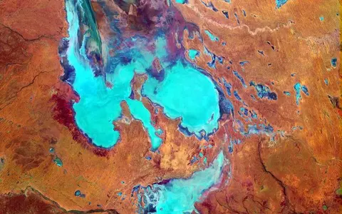
Lake Eyre North is the much larger, roughly north–south pan; Lake Eyre South lies beyond Goyder Channel to the south. The Warburton River and Warburton Groove enter the north, Cooper Creek approaches from the east, and the Macumba and Neales rivers reach the western side. The Tirari Desert lies to the east, Munga-Thirri–Simpson Desert farther northeast, and the northern Flinders Ranges and Marree are south of the lake.[2]
Two pans, grooves and uneven shallow floors
Lake Eyre North measures about 144 km north–south and up to 77 km across; those are plan-view dimensions of the basin, not the dimensions of open water on a particular date. Its floor is not a single level sheet. The lowest part lies in Belt Bay in Lake Eyre North, while broad grooves, islands and higher salt flats partition shallow floods. The smaller south lake can exchange water with the north through Goyder Channel when stage and local flow direction permit.[3][5][6]
The 9,500 km² mapped footprint likewise should not be read as normal water area. Digital Earth Australia measures observed wet surface rather than volume and warns that its special mapped outlines for both Lake Eyre North and South may not coincide with either a shoreline or another map's lake boundary. A small vertical change can therefore produce a large horizontal change across this very low-gradient floor.[2][7]
Main terminal pan
The Warburton system enters from the north and the lowest floor lies in Belt Bay.[5]
Goyder Channel
This shallow link separates two named basins; it is not an outlet from the drainage division.
Evaporite over fine sediment
Halite and gypsum occur with clay and silt deposited by successive lake, river and wind phases.[4]
Flood pulses lose water on the journey south
The dominant route is the Diamantina–Warburton system. Diamantina water spreads through Goyder Lagoon before the Warburton River and associated channels carry surviving flow toward Lake Eyre North. Georgina floods may stop in Lake Machattie or, in larger connected events, pass through Eyre Creek and join the Diamantina pathway. Cooper Creek follows a separate eastern route. Macumba, Neales and Arckaringa streams approach from the west, but their catchments are much smaller.[4][8]
Catchment membership does not mean that every named river is a functional tributary to the lake. The Todd, Plenty, Hay and Finke systems disperse into the Simpson Desert under the modern regime; Geoscience Australia's 2024 synthesis notes that even the 1974 flood produced no observed surface-water connection from the Finke through the Macumba to the lake.[4][8]
Floods move slowly through branching channels, waterholes, floodplains and claypans while infiltration and evaporation reduce their volume. The two major 2019 rainfall pulses illustrate that selectivity: they took 55 and 56 days to reach the lake; the first Georgina pulse stopped in Lake Machattie, the second joined the Diamantina, and Cooper Creek reached neither time. Water that does enter Kati Thanda–Lake Eyre has no surface route onward to the ocean.[1][8]
Rainfall is local; the largest supply is remote
The Commonwealth basin overview assigns the lake area about 140 mm of average annual rainfall and potential evaporation of about 2.5 m a year—nearly eighteen times the rainfall total. As a regional check rather than a lake-floor observation, the Bureau of Meteorology's Marree (Farina) station reports mean annual rainfall of 165.2 mm from 146 years with usable rainfall data between 1879 and 2026.[1][9]
The main supply therefore comes from episodic summer rainfall over northern and northeastern parts of the basin, where tropical and monsoonal systems can generate floods hundreds of kilometres away. Once inflow stops, evaporation lowers the shallow water rapidly; dissolved salts concentrate and precipitate as halite and gypsum while wind can rework exposed fine sediment. Local rain can fill southern or marginal pans without implying a basin-wide fill.[1][4]
A shifting depocentre with older shorelines
The playa is the modern surface expression of a longer depositional history, not simply a depression cut by today's rivers. It sits in the Tirari Sub-basin of the broader geological Lake Eyre Basin, where Cenozoic river, lake and wind-blown sediments accumulated above older Eromanga Basin rocks. Geoscience Australia's 2024 synthesis distinguishes this geological basin from the modern surface-water catchment and identifies the youngest sediment packages as thickest north of the present lake.[4]
Williams Point, on the southern margin of Madigan Gulf, exposes alternating lake-floor, fluvial, beach and wind-blown units. A 2022 luminescence chronology dated deeper-water lake sediment to 206 ± 13 thousand years ago and a younger beach deposit to 71 ± 4 thousand years ago; the latter records water about 12 m deep at that locality. These are dated palaeolake deposits, not estimates of the modern lake's age or normal depth.[10]
The same sequence records a high lake near +5 m AHD around 48 ± 2 thousand years ago, followed by exposed-floor conditions and gypsum-rich wind deposition. Old beach ridges and cliffs around the present salt pan therefore mark wetter phases and former shorelines well above the modern terminal floor.[10]
Depth and area need an event and a datum
Kati Thanda–Lake Eyre is extremely shallow relative to its area. South Australia's Level Post Bay record reports a 6.6 m water depth during the 1974–75 flood, measured at or near the deepest part of Lake Eyre North. That is a site-and-event depth; it should not be treated as a fixed maximum everywhere across the two pans.[11]
Likewise, −15 m AHD describes bed elevation, not water depth. AHD is a national vertical reference approximating mean sea level, and technical mapping rounds Lake Eyre North's lowest floor to that elevation. Flooded area, stage, depth and volume answer different questions; without a survey date, boundary method and vertical datum, they should not be combined into a single timeless "size".[3][5][7]
Channel Country to terminal salt pan
The lake is the final low in a connected sequence of upland headwaters, downs, anabranching river corridors, floodouts, dune fields, waterholes and claypans. The surrounding drainage divide separates this inland network from rivers reaching the Gulf of Carpentaria, the Coral Sea and the Murray–Darling system, but the lake itself lies wholly within South Australia.[1]
Return to the lake hub, follow the neighboring dunefield through the Simpson Desert, or compare stage-sensitive closed-basin hydrology with the Great Salt Lake. These are physical-geography connections, not claims that the deserts, drainage division and terminal lake share one boundary.
Sources and measurement notes
- Australian Government Department of Climate Change, Energy, the Environment and Water, “About the Lake Eyre Basin” (updated 2 July 2024; accessed 29 August 2026). Source for the dual name, 1.2 million km² drainage extent, four jurisdictions, internal drainage, flow losses, 140 mm local rainfall and 2.5 m potential annual evaporation.
- National Parks and Wildlife Service South Australia, Kati Thanda-Lake Eyre National Park and Elliot Price Conservation Park Management Plan (2025), pp. 3–6. Source for name context, physical-lake area of 950,000 ha, national-park area of 1,349,126 ha, location, low point and mapped neighboring features.
- South Australian Department for Environment and Water, Lake Eyre Basin Rivers Monitoring Project: Geomorphology of Finke River and Arckaringa Creek (2018; accessed 29 August 2026). Source for basin relief, −15 m AHD lowest-floor mapping in the southern bays of Lake Eyre North and the distinction between the two lake pans.
- Evans, T. J. et al., Geoscience Australia, Cenozoic geology, hydrogeology, and groundwater systems: Kati Thanda–Lake Eyre Basin, Record 2024/05 (2024). Source for geological-versus-hydrological basin scope, Tirari Sub-basin stratigraphy, sedimentation, major inflow systems and the modern limits of western and northwestern drainage.
- International Lake Environment Committee Foundation, “Lake Eyre,” World Lake Database record OCE-04 (accessed 29 August 2026). Used for the representative 28°30′S, 137°20′E coordinate and the placement of the lowest floor in Belt Bay; its stage-dependent 1974 physical-dimension table is not used as a modern normal-lake specification.
- South Australian Department for Environment and Water, “Everything you need to know about Kati Thanda-Lake Eyre” (20 June 2025; accessed 29 August 2026). Used only for the agency's 144 km by 77 km dimensions of Lake Eyre North and identification of Goyder Channel.
- Geoscience Australia, Digital Earth Australia, “DEA Waterbodies (Landsat)”, version 3.0 product documentation (accessed 29 August 2026). Source for wet-surface versus volume definitions, 1987–2020 maximum-observed-wet-area method and the special regional-polygon treatment of Lake Eyre North and South.
- Eyre, B. D. et al., “Significant greenhouse gas emissions from flooded drylands in Kati Thanda Lake Eyre basin in Australia”, Scientific Reports 16 (2026). Source for named inflows and the observed routing and 55–56-day travel of the two 2019 flood pulses; the page does not use the paper's emissions estimates.
- Australian Bureau of Meteorology, “Climate statistics for Australian locations: Marree (Farina), station 017024” (product prepared 20 August 2026; accessed 29 August 2026). Mean annual rainfall is 165.2 mm from 146 years of available rainfall data spanning 1879–2026; this is a regional station, not a lake-floor gauge.
- Cohen, T. J. et al., “Late Quaternary climate change in Australia's arid interior: evidence from Kati Thanda–Lake Eyre”, Quaternary Science Reviews 292 (2022), 107635. Source for the Williams Point sediment sequence, luminescence ages, palaeowater depth and +5 m AHD late-Quaternary lake stage.
- South Australian Department for Environment and Water, “Public Access Routes and sites of interest: Lake Eyre–Level Post Bay” (accessed 29 August 2026). Source for the site-specific 6.6 m water depth recorded during the 1974–75 flood.