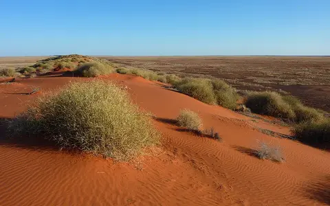

A physical desert, not a park or bioregion
Geoscience Australia's national desert table uses the short label Simpson; this page uses the established full name Simpson Desert. “Arunta Desert” occurs as a historical name in the geomorphological literature, but is not used here as a modern mapped extent.[1][3]
Munga-Thirri, meaning Big Sandhill Country, is the Wangkangurru Yarluyandi name used in the co-name of South Australia's 3.6-million-hectare Munga-Thirri–Simpson Desert National Park; Queensland has a separate Munga-Thirri National Park. These protected areas occupy parts of the wider desert and are not alternate boundaries for the whole physical feature.[10]
The three area figures on this page must remain separate. Geoscience Australia assigns the named desert 176,500 km² in the NT, Queensland and SA. Current IBRA7 records assign 12,962,073 ha (129,620.73 km²) to the Simpson Desert subregion, code SSD02, and 27,984,283 ha (279,842.83 km²) to the full Simpson–Strzelecki Dunefields region, which also includes Andado, Dieri, Warriner and Strzelecki Desert subregions and reaches NSW.[1][2]
A desert is an area rather than a point. None of those official tables identifies a surveyed centre, so this record does not invent a single latitude–longitude coordinate. Coordinates given below locate the Birdsville Airport climate station only; they do not define the desert's centre or boundary.
Interior lowlands between ranges and terminal basins
The Simpson occupies the eastern Interior Lowlands, east and southeast of the central Australian ranges. Its margins are transitions rather than surveyed walls: dune country approaches the Finke, Hale and Hay river floodouts toward the west and northwest, Channel Country drainage toward the east, and the Warburton River, Kallakoopah Creek and Kati Thanda–Lake Eyre lowlands toward the south. The Tirari Desert continues south of the Warburton corridor, while stony and gypsum plains interrupt the dunefield near the NT–SA border.[4][5][10]
A Northern Territory assessment of the western Great Artesian Basin catchments gives a useful local relief transect, not a whole-desert elevation range. It places flat-topped Jurassic–Cretaceous outcrops on the western and northern margin at up to about 400 m Australian Height Datum (AHD), with regional ground level falling southeast to about 50 m AHD. Within that low gradient, a 20- or 30-m dune is a significant obstacle to shallow overland flow.[5]
Parallel ridges over varied interdune floors
A linear or longitudinal dune is an elongated sand ridge aligned broadly with the net sand-moving wind regime. Across the Simpson, most crests trend northwest to north-northwest. A published synthesis gives a typical height range of 10–40 m, lengths from about 1 km to several hundred kilometres and spacing of roughly 100 m to 1.5 km. The ranges summarize earlier field studies rather than a uniform grid survey, and height, spacing, colour and swale material change across the desert.[3]
Interdune corridors are not simply bare sand. Depending on position, they include sandy swales, clay-rich flood flats, saline playas, gravel lag and dry channels. A continental review describes northern Simpson dunes more narrowly as 10–35 m high and about 500 m apart, with patchy hummock grass on crests and spinifex on flanks. That local northern description should not be generalized into a desert-wide average.[4]
NW to NNW alignment
Repeated linear ridges give the dunefield its strong directional grain, but junctions and local orientation changes occur.
Swales, pans and floodouts
Low corridors store fine sediment and salts and provide routes for brief runoff or ponding.
Vegetated, not fixed
Much of the dune body is stable while exposed crests and flanks undergo episodic centimetre-scale reworking.
River-delivered sand reorganized by wind
The desert is not a single heap of sand blown intact from a distant source. Mineral, grain-size and isotope evidence distinguishes at least two regional sand groups. Southeastern Simpson sand is associated with deflation—wind removal—of flood flats and salt-lake systems; northern and western sand is more closely tied to weathered underlying sediment. Much of the material was first carried into the interior by ancient rivers and was then redistributed locally into dunes by wind.[3]
Drill-core cosmogenic-isotope dating near Finke indicates that dune-field formation at that western Simpson site began about 1 million years ago. Luminescence ages record later episodes of dune building and soil formation. The figure dates one studied sector and a buried depositional history; it is evidence for an old, repeatedly reworked dunefield, not the age of every visible crest.[3][4]
The surface sand and younger alluvium conceal a deeper basin stack. Across much of the region, Jurassic and Cretaceous strata of the Eromanga Basin contain aquifers of the Great Artesian Basin groundwater system and overlie older basins and basement provinces. Northern Territory mapping and assessment place Eromanga rocks above Pedirka and Simpson basin sequences in parts of the region and beside Amadeus, Warburton and Georgina basin rocks; none of those geological names or areas is a synonym for the surface desert.[5][6]
Floodouts within an endorheic basin
The Simpson lies within the Lake Eyre Basin, an endorheic system: drainage terminates inland rather than reaching the sea. Basin streams flow only briefly after rain, spread through braided channels, floodplains, claypans and wetlands, and lose much of their water to infiltration and evaporation before it can reach Kati Thanda–Lake Eyre.[8]
Hydrology differs across the margins. The Georgina–Eyre Creek, Diamantina and Cooper systems carry fine sediment through the eastern Channel Country toward the Lake Eyre lowlands. By contrast, the Todd, Plenty, Hay and Finke rivers entering from the northwest carry sandier loads and, under the modern flow regime, generally diminish into the Simpson rather than reaching the terminal lake. Their floodouts are therefore sediment sources and temporary wetlands, not permanent tributaries crossing the desert from source to mouth.[4]
Within the dunes, storm runoff follows interdune lows, ponds in claypans and playas, or disappears into sand. Large floods can cut or reuse channels across dune corridors, while evaporation leaves clay and salt on low floors. Great Artesian Basin groundwater beneath the region is a separate, much older subsurface system; artesian springs around basin margins should not be described as outflows of the desert's ephemeral surface drainage.[5][8]
Hot aridity with event-driven rainfall
The Bureau of Meteorology's 1991–2020 rainfall maps place central Australian dryness beneath the subtropical high-pressure belt and far from dependable moisture sources. Rain may arrive in summer thunderstorms, tropical incursions or northwest cloudbands, but it falls on few days and varies strongly between years and across the desert.[9]
The 2008 rangelands assessment reported a spatially averaged median of 125 mm for the then 272,920-km² Simpson–Strzelecki Dunefields bioregion over 1890–2005, using rainfall years from 1 April to 31 March. The report warns that regional averaging conceals spatial variation. Current IBRA7 mapping gives the wider region a different 279,842.83-km² area, so the old rainfall statistic is retained with its original geography and period rather than relabelled as a current named-desert normal.[2][7]
Birdsville Airport provides an eastern-margin station example. At 25.90°S, 139.35°E and 47 m elevation, the Bureau's all-years table reports mean annual rainfall of 161.2 mm from 25 available years between 2000 and 2026, an annual mean daily maximum of 31.7°C, and a January mean maximum of 40.8°C from 26 available years. These values describe that station and its available-data periods—not the desert core, a fixed 30-year normal or desert-wide extremes.[9]
Old ridges with mobile surfaces
Vegetation and surface crusts stabilize much of each ridge, but stability is not immobility. An eight-year study of one Simpson dune recorded several centimetres of annual sand movement on average, with greater changes on the crest and upper flanks; individual stakes alternately showed burial and deflation. The study demonstrates local surface reworking and does not supply a migration rate for the entire dunefield.[3]
Water works more episodically than wind. A rare storm can scour a channel, erode a dune toe, spread new alluvium across a floodout and fill a playa; a subsequent dry interval can expose fine sediment to deflation and concentrate salts. The visible landscape therefore combines million-year dune inheritance, shorter glacial-cycle building phases and event-scale reshaping.[3][4]
Follow the basin and dune margins
Continue south through the Strzelecki Desert to compare a related but separately named dunefield, or follow the terminal drainage to Kati Thanda–Lake Eyre. Return to the Desert Hub for category-wide navigation.
These links preserve the central distinction of this record: the Simpson Desert is a physical dune desert within a larger drainage basin, not the whole Lake Eyre watershed, the entire Simpson–Strzelecki bioregion, or any one protected area.
Sources and measurement notes
- Geoscience Australia, “Areas of Australian and territory deserts” (Deserts database, 1994; revised 2022; accessed 29 August 2026). Source for the “Simpson” table label, NT–Queensland–SA scope and 176,500-km² named-desert area. The page publishes no desert polygon, centre coordinate, perimeter or area method.
- Australian Government Department of Climate Change, Energy, the Environment and Water, “Interim Biogeographic Regionalisation for Australia (IBRA7) Codes” (updated 9 May 2025), and IBRA7 subregions and codes (accessed 29 August 2026). The current tables give 27,984,283 ha for the Simpson–Strzelecki Dunefields region and 12,962,073 ha for its Simpson Desert subregion SSD02. This page converts hectares to square kilometres at 100 ha per km².
- Craddock, R. A. et al., “Temporal observations of a linear sand dune in the Simpson Desert, central Australia: Testing models for dune formation on planetary surfaces”, Journal of Geophysical Research: Planets 120 (2015), doi:10.1002/2015JE004892. Used for orientation, literature-synthesized dune dimensions, historical name, sand groups and provenance, chronology, and the explicitly single-dune 2006–2014 monitoring results.
- Pepper, M. and Keogh, J. S., “Life in the ‘dead heart’ of Australia: The geohistory of the Australian deserts and its impact on genetic diversity of arid zone lizards”, Journal of Biogeography 48 (2021), pp. 716–746, doi:10.1111/jbi.14063. Physical-geography synthesis used for Interior Lowlands setting, northern Simpson dune dimensions, long-term episodic dune formation, eastern and northwestern drainage contrasts, and sediment delivery.
- Northern Territory Department of Land Resource Management, Technical Report: Great Artesian Basin Resource Assessment (2012). Used for the Western Catchments Division's approximately 400-to-50-m AHD regional relief gradient, linear dunes, Hay, Plenty and Finke drainage, playa occurrence and Great Artesian Basin context. The elevation figures are not presented as whole-desert extrema.
- Northern Territory Geological Survey, Munson, T. J., “Chapter 41: Eromanga Basin,” in Ahmad, M. and Munson, T. J. (compilers), Geology and mineral resources of the Northern Territory, Special Publication 5 (2013; geology current to May 2012). Used for the mapped Eromanga cover, Jurassic–Cretaceous units and relationship to older basins beneath the NT part of the desert.
- Australian Government, Rangelands 2008—Taking the Pulse: Simpson–Strzelecki Dunefields bioregion (2008). Source for the older 272,920-km² bioregion scope and spatially averaged 125-mm median rainfall for 1890–2005 using an April–March rainfall year. Its superseded area is not substituted for the current IBRA7 figure.
- Australian Government Department of Climate Change, Energy, the Environment and Water, “About the Lake Eyre Basin” (accessed 29 August 2026). Used for endorheic drainage, short-lived streamflow, southward dispersal through channels and floodplains, infiltration and evaporation losses, and the distinction between surface water and Great Artesian Basin springs.
- Australian Bureau of Meteorology, “Average annual, seasonal and monthly rainfall maps” (1991–2020 climatology), and “Climate statistics for Australian locations: Birdsville Airport, station 038026” (all available data; accessed 29 August 2026). Used for central Australian rainfall controls and for the station's coordinates, AHD-unqualified site elevation, available-year counts, rainfall and mean-maximum-temperature values.
- Government of South Australia, Department for Environment and Water, Munga-Thirri–Simpson Desert National Park Management Plan 2022 (2022). Used for the meaning and protected-area use of Munga-Thirri, the 3.6-million-hectare SA park scope, adjoining Queensland park, and the mapped southern watercourses and park boundaries. Unsupported global superlatives in the plan are not repeated here.