
A region, a crest, and several different boundaries
The name Karakoram is used at more than one scale. The 1936–37 Karakoram Conference, whose recommendations were accepted by the Royal Geographical Society and approved by the Surveyor-General of India, bounded the full mountain region by the Shyok, Indus, and Gilgit rivers on the south; the Ishkoman–Karumbar corridor on the west; a line through Chilinji, Khunjerab, the Shaksgam valley, and Rimo on the north; and the upper Shyok on the east. That definition explicitly excludes the Aghil Mountains, the Ladakh Range between the Shyok and Indus, and mountains east of the upper Shyok. (Karakoram Conference report)
Within that region, the Great Karakoram means the main crest zone. From west to east the conference divided it into the Batura, Hispar, Panmah, Baltoro, Siachen, Rimo, and Saser muztaghs; muztagh means an ice mountain or ice-mountain group. A satellite study that digitized the classic physical boundary obtained approximately 44,500 km² and an elevation span from about 1,250 m to 8,611 m. The low value is a valley-floor elevation inside the mapped perimeter, not the “base” of K2. Modern glacier studies may use revised GIS boundaries, so their areas should not be divided by 44,500 km² without first reconciling the footprints. (Bhambri and others, 2017)
Massifs separated by glacier troughs
K2 reaches 8,611 m above sea level; NASA also identifies three other summits above 8,000 m within 20 km of it. That summit elevation is not a measure of local relief. Relief is the vertical difference between a summit and a specified nearby valley or surface, and no single value represents a region whose mapped elevations span more than 7 km. (NASA Earth Observatory)
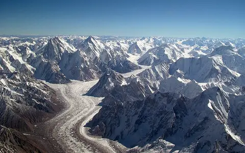
The main crest is not one unbroken ridge. Glacier source basins and transverse troughs separate the Batura, Hispar, Panmah, Baltoro, Siachen, Rimo, and Saser groups, while the Rakaposhi, Haramosh, Masherbrum, and Saltoro ranges form important lesser alignments. In the central Karakoram, steep headwalls deliver snow by avalanche and rock debris by falls and slides. Glaciers then carry that material into medial moraines and broad debris-covered tongues, linking high rock walls to lower valley floors. (Karakoram Conference report; Bhambri and others, 2017)
Older subduction rocks inside a younger collision belt
The Karakoram is built chiefly from crust that belonged to the southern Asian margin, north of the sutures where oceanic crust and the Kohistan–Ladakh arc were consumed or accreted. It is therefore related to the India–Asia collision but is not simply the northwest end of the same rock belts that make up the Himalayas. After collision of India, the Kohistan arc, and Asia at about 50 million years ago, crustal shortening and thickening uplifted Asian-plate crust in the Karakoram and produced regional high-grade metamorphism and granitic intrusions. (Searle and Hacker, 2018)
The rocks do not share one formation age. In the eastern Karakoram, zircon dating records Karakoram Batholith magmatism at about 110–100 million years ago, when Tethyan oceanic lithosphere was subducting beneath Asia. In the central Baltoro and Hunza regions, later collision thickened, deformed, metamorphosed, and partially melted the crust; dating summarized by Searle and colleagues places high-grade metamorphism over at least about 50–13 million years ago, while intrusion of the Baltoro granite batholith spanned 26.4–13 million years ago. A batholith is a large body of magma crystallized underground and later exposed by uplift and erosion. These dated events describe particular rock units, not the age of every summit. (Pundir and others, 2020; Searle and others, 2010)
Asian-plate margin
Karakoram rocks preserve pre-collision subduction as well as later India–Asia collision effects.
Metamorphic and granitic
Burial heated and altered older rocks; partial melting produced large granite bodies.
Ice and mass movement
Glacial incision, frost breakdown, rockfall, and landsliding continue to reshape the relief.
A dated ice area with a stated mapping error
A homogeneous inventory published in 2023 mapped 10,498 glaciers with a combined plan-view area of 22,510.73 ± 828.39 km² for the 2020s. The authors composited 30-m Landsat imagery, used band ratios followed by manual correction, and assigned a ±3.68% outline uncertainty. Seasonal snow, deep shadow, rock outcrops, and debris-covered ice are major sources of mapping uncertainty, so the result is an inventory estimate, not a surveyed ice volume. (Xie and others, 2023)
In that same inventory, 26 glaciers exceeded 100 km² and together occupied 7,430.64 ± 273.45 km². The four largest mapped units were Siachen (1,118.09 ± 41.14 km²), Baltoro (849.44 ± 31.26 km²), Biafo (579.25 ± 21.32 km²), and Hispar (542.07 ± 19.95 km²). These are areas under that inventory's glacier-unit rules; they should not be substituted for route lengths, drainage-basin areas, or older published outlines.
Near-stable total area masks opposing regional trends
Using consistent inventories for the 1990s through 2020s, Xie and colleagues found a small, statistically insignificant total area increase of 23.45 ± 28.85 km², or 0.10 ± 0.13%. The regional pattern was not uniform: eastern Karakoram glacier area declined 3.27 ± 0.24%, while central and western sectors increased 0.65 ± 0.10% and 1.26 ± 0.11%, respectively. Total area first increased toward the 2010s and then decreased. “Karakoram anomaly” is therefore shorthand for an unusual regional pattern over a defined observation period, not evidence that every glacier is growing or immune to warming. (Xie and others, 2023)
Area, length, and mass are different measurements. A glacier tongue can advance because a surge rapidly transfers ice from an upper reservoir to a lower receiving zone without adding ice to the glacier as a whole. A 2017 satellite and historical inventory identified 210 surge-type, surge-like, or surge-modified cases within the Karakoram; active phases ranged from months to more than 15 years. A later central-Karakoram study found typical repeat intervals of 40–60 years but a much wider observed range. The timing and mechanism are glacier-specific, so an advancing terminus alone is not a climate indicator. (Bhambri and others, 2017; Paul and others, 2022)
Winter westerlies, a variable monsoon, and steep gradients
The Karakoram lies between the winter-westerly circulation of Central Asia and the South Asian summer monsoon. Climate-model analysis identifies non-monsoonal winter precipitation as the dominant contribution to the range-scale seasonal cycle, unlike the summer-accumulation regime of much of the central and eastern Himalayas. Monsoon moisture still reaches the southeast and can enter farther west during particular circulation patterns; neither “monsoon-free” nor uniformly dry describes the whole range. (Kapnick and others, 2014)
Elevation, aspect, wind redistribution, and avalanche feeding create sharper local contrasts than low-valley stations can resolve. For the Baltoro sector, a 2024 study synthesized mean annual precipitation near 1,600 mm at about 5,300–5,500 m, while also warning that its 10-km regional climate grid is too coarse for the terrain. That figure describes high accumulation areas near Godwin Austen and Baltoro South, not a Karakoram-wide average. On Baltoro Glacier, mapped supraglacial lakes commonly filled from mid-April to mid-June and drained from mid-June to mid-September during the study years, illustrating how warm-season meltwater reorganizes water stored on the ice. (Wendleder and others, 2024)
A divide between the upper Indus and Tarim basins
The main crest partitions glacier and snowmelt between two large inland-facing and ocean-reaching systems. South and west of the divide, the Gilgit–Hunza, Shigar, and Shyok sub-basins route water into the upper Indus and ultimately the Arabian Sea. North of the crest, Shaksgam and other headwaters enter the Yarkand system and the closed Tarim Basin. The 2023 glacier inventory accordingly divides the range among Wakhan, Gilgit–Hunza, Shigar, Shyok, and sub-Tarim drainage units rather than treating “Karakoram runoff” as one flow. (Xie and others, 2023)
Snowfall is temporarily stored in seasonal snow and glacier accumulation zones; melt, rain, and water released from or beneath glaciers then move through steep tributaries. Rockfall and moraines supply large sediment loads, while glacier surges can narrow or block a valley and impound water. These processes vary by catchment and season, so the glacier-area inventory cannot by itself be converted into a discharge estimate.
Distinct from its neighboring ranges and protected areas
The Karakoram approaches the Pamirs and Hindu Kush in the west and the Tibetan highlands and Kunlun to the northeast. To the south, the Indus and Shyok valleys help separate it from the Himalayas and Ladakh Range. These are physiographic relationships: the landform crosses modern administrative frontiers, while its scientific boundary follows rivers, passes, and crest lines rather than a political border.
Central Karakoram National Park is a protected area in Gilgit-Baltistan, Pakistan. UNESCO's tentative-list description reports 10,557.73 km², but an integrity paragraph on the same page reports 10,333.3 km²; without a current legal boundary dataset, neither should be presented as more precise than the other. The record places the Baltoro, Biafo, Hispar, and Chogo Lungma glacier systems within that central sector, but the park is not synonymous with the full range. UNESCO also uses the variant spelling Karakorum; this atlas retains Karakoram, the spelling used by the RGS–Survey of India nomenclature and most cited scientific inventories. (UNESCO World Heritage Centre)
Data sources and publications
- Karakoram Conference. Karakoram Conference Report, recommendations accepted by the Council of the Royal Geographical Society and approved by the Surveyor-General of India, published in Himalayan Journal 10 (1938). Full-region limits, Great Karakoram crest, muztagh divisions, and exclusions.
- Bhambri, R., Hewitt, K., Kawishwar, P., and Pratap, B. “Surge-type and surge-modified glaciers in the Karakoram.” Scientific Reports 7, 15391 (2017). Digitized classic range boundary, mapped area and elevation span, avalanche and debris processes, and surge inventory.
- NASA Earth Observatory. Karakoram Range, Pakistan, 23 February 2000, accessed 30 August 2026. K2 elevation and nearby 8,000-m summit context.
- Searle, M. P., and Hacker, B. R. “Structural and metamorphic evolution of the Karakoram and Pamir following India–Kohistan–Asia collision.” Geological Society, London, Special Publications 483 (2018), 555–582. Plate setting, collision timing, crustal thickening, metamorphism, and granitic melting.
- Pundir, S., Adlakha, V., Kumar, S., and Singhal, S. “Closure of India–Asia collision margin along the Shyok Suture Zone in the eastern Karakoram.” Geological Magazine 157 (2020), 1451–1472. Eastern Karakoram Batholith ages and subduction setting.
- Searle, M. P., Parrish, R. R., Thow, A. V., Noble, S. R., Phillips, R. J., and Waters, D. J. “Anatomy, age and evolution of a collisional mountain belt.” Journal of the Geological Society 167 (2010), 183–202. Baltoro and Hunza metamorphism and batholith chronology.
- Xie, F., Liu, S., Wu, K., Zhu, Y., Gao, Y., Qi, M., Duan, S., Tahir, A. A., Wang, X., and Saifullah, M. “Interdecadal glacier inventories in the Karakoram since the 1990s.” Earth System Science Data 15 (2023), 847–867. Revised study boundary, Landsat method, 2020s glacier count and area, uncertainty, named large-glacier areas, drainage divisions, and 1990s–2020s change.
- Paul, F., Strozzi, T., Schellenberger, T., and Kääb, A. “Three different glacier surges at a spot: what satellites observe and what not.” The Cryosphere 16 (2022), 2505–2526. Surge definition, recurrence range, mass redistribution, and central-Karakoram climate limits.
- Kapnick, S. B., Delworth, T. L., Ashfaq, M., Malyshev, S., and Milly, P. C. D. “Snowfall less sensitive to warming in Karakoram than in Himalayas due to a unique seasonal cycle.” Nature Geoscience 7 (2014), 834–840. Range-scale winter-precipitation control and modeled snowfall sensitivity.
- Wendleder, A., Mayer, C., Lambrecht, A., Floricioiu, D., and Braun, M. H. “Velocity variations and hydrological drainage at Baltoro Glacier, Pakistan.” The Cryosphere 18 (2024), 1085–1106. Baltoro dimensions, climate controls, high-elevation precipitation context, model limitations, debris, melt, and supraglacial-lake seasonality.
- UNESCO World Heritage Centre. Central Karakorum National Park, Tentative List submission dated 12 April 2016, accessed 30 August 2026. Central-sector glaciers, tectonic and landslide context, distinction from the full range, and the page's unresolved 10,557.73/10,333.3 km² area discrepancy.