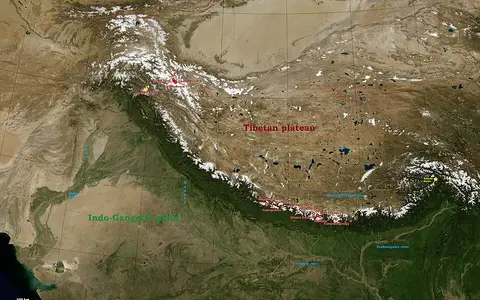

The range is narrower than the wider Asian highlands
Himalayas is the Permanent Committee on Geographical Names’ recommended English group name; its listed local forms include Himālaya in Nepal and India, Ximalaya in China, and Himaliya in Pakistan. PCGN assigns the group the locator 28°00′ N, 84°00′ E. Because the feature is an arc thousands of kilometres long, that point is useful for indexing but cannot represent an exact centre, outline, or map boundary. (PCGN India Toponymic Factfile, updated May 2026)
This page covers the Himalayan fold-and-thrust belt from the western Hazara syntaxis to the eastern Namche Barwa syntaxis. A syntaxis is a tight bend where the structures of a mountain belt converge. A peer-reviewed structural definition gives this arc a length of about 2,400 km, bounded in the north by the Indus–Yarlung suture and in the south by the Main Frontal Thrust and related buried faults beneath the northern foreland basin. The natural edges are gradational, so the figure is a defined structural arc-length rather than a measured summit route, and no single defensible range area is presented here. (DeCelles and others, 2002)
The neighboring Karakoram and Hindu Kush are distinct ranges, while the Tibetan Plateau is the elevated region north of the Himalayan belt. “Hindu Kush Himalaya” and “High Mountain Asia” are broader research regions whose glacier, population, or water statistics must not be relabelled as measurements of the Himalayas alone.
Parallel belts rise from foothills to the high crest
From south to north, much of the range can be read as four longitudinal rock belts. The Sub-Himalaya, including the Siwalik foothills, contains deformed sediment eroded from the rising range. The Lesser Himalaya exposes older low- to medium-grade rocks. The Greater Himalayan sequence contains high-grade metamorphic rocks and granitic intrusions and supports much of the highest relief. Farther north, the Tethyan Himalaya is built mainly from sedimentary rocks deposited along the former northern Indian margin. The Main Boundary Thrust, Main Central Thrust, and South Tibetan Detachment separate major parts of this stack. (Blum and others, 2018)
These geologic sequences do not map perfectly onto the everyday labels Outer, Lesser, and Greater Himalaya: thrust sheets and isolated structural remnants cross the physiographic boundaries. Nor is the range one crest. Branching ridges enclose longitudinal valleys, while the Sutlej, Kali Gandaki, Arun, and other rivers cut transverse gorges through major topographic steps. In studied plateau-fed channels, the transition into the Himalayan realm commonly includes a marked steepening at roughly 3,000–4,000 m channel elevation; that interval describes river profiles, not the elevation of a range boundary. (Robl and others, 2008)
Mount Everest—Sagarmatha in Nepal and Qomolangma in China—stands on the Nepal–China boundary in the Mahalangur Himal. Nepal and China jointly announced 8,848.86 m in December 2020. The value is the height of the snow-covered summit referred to the International Height Reference System; gravity observations, levelling, terrain data, and satellite positioning were combined to establish the reference surface and summit height. It should not be rounded into a different survey value or interpreted as base-to-summit relief. (Sagarmatha National Park Office; International Association of Geodesy, 2021; Government of China measurement explanation)
Continental collision built a faulted rock wedge
Before collision, marine basins of the Neo-Tethys separated India from Eurasia. As India moved north, oceanic crust was consumed and the continental margins met during the early Cenozoic. The exact time of first contact remains debated; early-to-middle Eocene sediments in the Himalayan foreland record erosion from an already developing fold-and-thrust belt. Continuing convergence shortened the northern Indian margin, metamorphosed deeply buried rocks, generated granitic melts, and drove large sheets of rock southward along thrust faults. (DeCelles and others, 2002)
At depth, the Main Himalayan Thrust is the basal plate-boundary fault on which Indian crust underthrusts the mountain wedge. Its geometry links the deep collision to uplift and deformation nearer the surface. Parts of the fault remain locked between earthquakes, storing elastic strain that can be released during major ruptures; therefore “young fold mountains” is an incomplete classification. Folding, thrusting, metamorphism, crustal thickening, erosion, and the earthquake cycle are all active parts of the system. (Dal Zilio and others, 2021)
Main Himalayan Thrust
The Indian plate descends beneath the range along a shallow, north-dipping fault system.
Siwalik fold belt
Foreland-basin sediment has been folded and thrust above the plains at the active southern margin.
Denudation
Rivers, landslides, glaciers, and weathering remove mass while tectonic shortening rebuilds relief.
Monsoon rain, winter westerlies, and a Tibetan rain shadow
Summer monsoon air rises against the southern relief, cools, and loses moisture. A synthesis of TRMM satellite observations and more than 1,700 rain gauges found that the strongest east-to-west rainfall gradient is in the low foreland below 500 m, while the mountainous belt from 500 to 5,000 m had a much weaker along-range gradient. In the same 1998–2007 analysis, summer monsoon rain supplied more than 80% of annual rainfall in the central Himalaya and adjoining plateau, but only about half at the western and eastern syntaxes. Those percentages are study-period regional estimates, not values for every slope or year. (Bookhagen and Burbank, 2010)
Cross-range contrasts are sharper. The same satellite-era work places heavy rainfall bands where relief first rises above the foreland and, in some sectors, where the Greater Himalaya rises farther north. A related review reports roughly 1–3 m of wet-season rain over the foreland compared with less than 0.5 m on the Tibetan Plateau in the rain shadow. Western disturbances carried in the westerlies add important winter snow, especially in the west; elevation, slope aspect, valley orientation, and local relief then redistribute snowfall and rainfall at much finer scales. (Burbank and others, 2012)
Measured ice loss varies across a monsoon-to-westerlies transition
Himalayan glaciers occupy high cirques and valleys, but their nourishment differs along the arc. Central and eastern glaciers receive much of their accumulation during the summer monsoon; winter and spring snowfall from western disturbances becomes more important westward. Thick surface debris can suppress melt where it insulates ice, while exposed ice cliffs, ponds, and lake-terminating fronts can concentrate melt. These contrasts are why ice statistics for the Karakoram or all of High Mountain Asia cannot be substituted for a Himalaya-only result. (Nie and others, 2021)
A satellite study reconstructed surface-height change for 650 of the larger glaciers along a 2,000 km Himalayan transect. Mean loss increased from 0.22 ± 0.13 m water equivalent per year in 1975–2000 to 0.43 ± 0.14 m water equivalent per year in 2000–2016. “Metres water equivalent” expresses the lost mass as an equivalent depth of water averaged across the sampled glacier area; it is not a retreat distance, a current glacier area, or a forecast. The intervals also should not be extended to the present as though the measured rate were constant. (Maurer and others, 2019)
A 2026 synthesis of field measurements provides a different, smaller sample: 302 annual balances from 38 Himalayan glaciers over 1974–2023. It calculated an area-and-duration-weighted mean loss of 0.62 ± 0.33 m water equivalent per year, while warning that many series are short, concentrated on relatively small glaciers, and can be biased where accumulation areas were not fully measured. That value should not be averaged with the 650-glacier geodetic result because the sampling and methods differ. (Azam, 2026)
The mountains divide catchments, but major rivers cross the belts
Himalayan runoff reaches three principal systems. Western rivers enter the Indus; the Ganges headwaters and tributaries drain the central and southern flanks; and eastern tributaries join the Brahmaputra. The upper Yarlung Tsangpo lies north of the Indus–Yarlung suture on the Asian plate before bending around the eastern syntaxis and crossing the mountain system. It is therefore inaccurate to say that every part of the Indus or Brahmaputra begins within the Himalayas proper. (Blum and others, 2018)
The crest is not a simple continental divide. The Sutlej, Kali Gandaki, Arun, and other plateau-linked rivers descend through deep transverse gorges, while shorter tributaries rise on the southern slopes and flow into the Ganges foreland. Whether individual cross-range courses survived uplift as antecedent rivers or were assembled partly by headward erosion and river capture remains debated; numerical models show that capture is a plausible mechanism for several plateau-fed systems. (Robl and others, 2008)
Rain, snowmelt, and glacier melt have different weights by basin and season. The 1998–2007 hydrological model estimated snowmelt at up to 50% of annual discharge in far-western Indus-area catchments, about 25% in the far eastern Tsangpo catchments, and less than 20% elsewhere in its 27-basin sample. Monsoon floods and steep channel gradients mobilize landslide and river sediment, which is stored temporarily in valleys and the foreland before continuing toward the Indus plain or the Ganges–Brahmaputra delta and Bengal Fan. (Bookhagen and Burbank, 2010; Blum and others, 2018)
Data sources and publications
- Permanent Committee on Geographical Names. India Toponymic Factfile, updated May 2026, pp. 11–12 (accessed 30 August 2026). Recommended English name, local forms, feature type, locator coordinate, and mapping cautions.
- DeCelles, P. G., Robinson, D. M., and Zandt, G. “Implications of shortening in the Himalayan fold-thrust belt for uplift of the Tibetan Plateau,” Tectonics 21(6) (2002). Defined 2,400 km arc, syntaxial limits, structural boundaries, rock sequences, and uncertainty in collision timing.
- Sagarmatha National Park Office. Establishment (accessed 30 August 2026). Official Nepali use of Sagarmatha and the Everest setting on the Nepal–China boundary.
- International Association of Geodesy. New Height of Mount Everest, 28 January 2021; Government of China, Measuring a mountain: new Mount Qomolangma height explained in 100 seconds, 10 December 2020. Joint 8,848.86 m snow-surface value, International Height Reference System, geoid, and measurement inputs.
- Blum, M., Rogers, K., Gleason, J., Najman, Y., Cruz, J., and Fox, L. “Allogenic and Autogenic Signals in the Stratigraphic Record of the Deep-Sea Bengal Fan,” Scientific Reports 8, 7973 (2018). Himalayan rock belts, major faults, Ganges and Brahmaputra source areas, erosion, sediment routing, and Bengal Fan connection.
- Dal Zilio, L., Hetényi, G., Hubbard, J., and Bollinger, L. “Building the Himalaya from tectonic to earthquake scales,” Nature Reviews Earth & Environment 2 (2021), 251–268. Main Himalayan Thrust, ongoing shortening and thickening, denudation, segmentation, and the earthquake cycle.
- Bookhagen, B., and Burbank, D. W. “Toward a complete Himalayan hydrological budget: Spatiotemporal distribution of snowmelt and rainfall and their impact on river discharge,” Journal of Geophysical Research: Earth Surface 115, F03019 (2010). Ten years of 1998–2007 TRMM observations, calibration with 1,741 gauges, 27 catchments, monsoon fractions, snowmelt estimates, and drainage.
- Burbank, D. W., Bookhagen, B., Gabet, E. J., and Putkonen, J. “Modern climate and erosion in the Himalaya,” Comptes Rendus Geoscience 344 (2012), 610–626. Orographic rainfall bands, Tibetan rain shadow, seasonal circulation, runoff, and erosion contrasts.
- Maurer, J. M., Schaefer, J. M., Rupper, S., and Corley, A. “Acceleration of ice loss across the Himalayas over the past 40 years,” Science Advances 5(6), eaav7266 (2019). Satellite-derived glacier-height change, sampled transect, dated mass-loss rates, water-equivalent units, and uncertainties.
- Azam, M. F. “Fifty years of Himalayan glacier mass-balance monitoring: Recommendations in honour of IYGP 2025,” Journal of Glaciology (published online 24 March 2026). Field records through 2023, sample coverage, weighting, uncertainty, and possible observation bias.
- Robl, J., Stüwe, K., Hergarten, S., and Evans, L. “Channel profiles around Himalayan river anticlines: Constraints on their formation from digital elevation model analysis,” Tectonics 27, TC3010 (2008). Cross-range channel steepening, incision, headward erosion, and the capture alternative to simple antecedent-drainage explanations.
- Nie, Y., Pritchard, H. D., Liu, Q., and others. “Glacial change and hydrological implications in the Himalaya and Karakoram,” Nature Reviews Earth & Environment 2 (2021), 91–106. Himalaya–Karakoram differences, heterogeneous glacier retreat, changing ice storage, runoff, and glacial-lake processes.