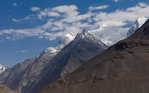
.jpg)
Name, scope, and range limits
The accepted English conventional name is Hindu Kush; the BGN/PCGN romanization of the Afghan-script name هندو کش is Hindū Kush. Joined forms such as “Hindukush” occur in scientific titles, but this record uses the two-word conventional name.[1] The feature is a set of main ridges, side ranges, massifs, and deeply incised valleys rather than one continuous crest.
This page follows the 1990 orographic scheme summarized by geographer Erwin Grötzbach: Darra-ye Shekari and Shibar Pass at the western end; the Khawak and Dorah passes as internal divisions; and Baroghil Pass plus the Yarkhun–Mastuj–Chitral valleys at the eastern transition to the Hindu Raj and Karakoram. The Kokcha valley separates the range from northern Badakhshan mountains, and the Panj valley separates it from the Pamir.[2] This narrow physical definition is principally in Afghanistan and Pakistan. Gazetteers may assign the international feature to Afghanistan, Pakistan, and Tajikistan, illustrating that mapped scope is not uniform.[1]
Under that 1990 boundary scheme, the range and bordering valleys cover about 55,000 km², including about 10,000 km² in Pakistan.[2] That is a published regional estimate, not an area recalculated from a modern range polygon, so it should not be combined with broader “Hindu Kush Himalaya” statistics.
Relief rises sharply toward Chitral
The western Hindu Kush, from Darra-ye Shekari and Shibar Pass to Khawak Pass, reaches about 5,126 m in the cited four-part scheme. The central sector between Khawak and Dorah rises to about 6,843 m. East of Dorah, several summits exceed 7,000 m before the range ends at Baroghil Pass.[2] Tirich Mir stands south of the main border crest on a side ridge projecting into Chitral, Pakistan; it is therefore the range high point without being a border summit.
Published elevations for Tirich Mir differ slightly. An August 1965 panorama survey used a theodolite, a 1:126,720 map base, curvature and standard-refraction corrections, and returned 7,708 m; its author stated a general uncertainty of about ±25 m. The same paper recorded 7,706 m as the accepted value at that time, and the later orographic synthesis also uses 7,706 m. Pakistan’s 2023 provincial census report prints 7,690 m but supplies no survey method or vertical datum. All three values fit within the 1965 study’s stated uncertainty, so this record reports about 7,700 m rather than implying one-metre accuracy.[8][2][10]
A joint USGS–Geological Survey of Pakistan study of 3,626 km² on the southern flank near Chitral reported local relief above 8,000 ft (about 2,440 m) across most of its map area and commonly reaching 14,000 ft (about 4,270 m). Those values describe the surveyed Chitral–Partsan area, not an average for the full range.[3] Rivers, glaciers, rockfall, and debris flows exploit faults and weaker rock belts, cutting narrow valleys between resistant ridges.
Dorah to Baroghil
Seven-thousand-metre summits and the most concentrated high-alpine relief occupy the Afghanistan–Pakistan sector.
Shibar to Khawak
Lower crests spread into Afghanistan’s central highlands, where the boundary with Koh-i-Baba is a transition rather than a surveyed line.
An assembled crust, still deforming
“Fold mountain” is too simple a label for the Hindu Kush. Regional syntheses describe abundant schist, gneiss, and marble, intruded by granitic and dioritic bodies of different ages.[2] In the mapped Chitral–Partsan sector, Devonian-to-Cretaceous sedimentary successions were metamorphosed, intruded by granite and granodiorite, and displaced by thrust faults. This mixture records older ocean closure and terrane assembly as well as later India–Asia collision. [3]
Active deformation is distributed through thrust and strike-slip fault systems rather than confined to a single range-front fault. Seismic tomography published in 2021 images a north-dipping Indian lithospheric slab beneath the Afghan Hindu Kush that becomes thinner and steeper eastward. The authors interpret it as ongoing slab break-off. Intermediate-depth earthquakes occur at roughly 60–300 km, far below ordinary crustal faulting; the proposed slab process is a model supported by tomography and seismicity, not a feature visible at the surface.[4]
More than one orogeny
Metamorphic belts and intrusions preserve events older than the modern relief.
Fault-partitioned deformation
Thrusting, strike-slip motion, and distributed strain accommodate continuing convergence.
Deep seismic zone
The 60–300 km earthquake band is distinct from shallow landslide-producing crustal earthquakes.
A divide among oceanic and closed basins
The main ridge does not divide only the Amu Darya and Indus systems. In the northeast, the Kokcha and Kunduz rivers carry snowmelt north to the Amu Darya. Some shorter north-flowing rivers disappear on the Turkistan plain before reaching it. East and south of the crest, the Chitral River becomes the Kunar in Afghanistan, joins the Kabul near Jalalabad, and reaches the Indus in Pakistan. The Panj is chiefly the northern boundary between Hindu Kush and Pamir terrain, not simply a river sourced inside the range.[2][5]
Farther west, the drainage divides become more intricate. The Kabul rises about 100 km west of Kabul city and flows east to the Indus; nearby headwaters of the Helmand flow southwest to the Sistan depression. The Hari Rod and Murghab drain western highlands toward Iran and Turkmenistan and end in inland oases or desert rather than reaching an ocean.[5] Flow timing also differs: spring snowmelt is prominent in Kabul, Kokcha, and Kunduz tributaries, while glacier melt helps sustain eastern high-mountain streams later in the dry season.[2][5]
Amu Darya and inland plains
Kokcha and Kunduz reach the Amu Darya; several smaller streams lose flow before the main river.
Kunar–Kabul–Indus
Chitral/Kunar runoff crosses Pakistan and Afghanistan before returning to Pakistan and the Indus.
Helmand, Hari Rod, Murghab
These rivers terminate in Sistan or in arid interior basins west and north of Afghanistan.
Westerlies meet a weak monsoon margin
Winter and spring westerly circulation supplies much of the high-elevation precipitation in the Hindu Kush–Karakoram sector. The southeastern slopes in Nuristan and southern Chitral lie on the fringe of the summer monsoon, whereas northern and northwestern slopes receive less precipitation and inner valleys lie in rain shadow.[2][6] Elevation, slope aspect, and valley orientation can therefore matter as much as straight-line distance: adjacent windward and sheltered valleys may have markedly different snow cover and vegetation.
Glaciers are concentrated above roughly 5,000–5,500 m in the central and eastern Hindu Kush and on shaded high slopes; seasonal snow extends much lower and over a wider area.[2] A 2016 Landsat-based inventory mapped 3,408 glaciers at least 0.01 km² across the broader Afghanistan Hindu Kush Himalaya study area. It estimated 2,841 ± 51 km² of total glacier surface, including 619 ± 40 km² of debris-covered ice.[7]
Measurement boundary: the 2016 glacier inventory covers Afghanistan’s wider Hindu Kush Himalaya, not the narrow range boundary used on this page. Its glacier count and area are evidence for regional ice cover and mapping uncertainty; they are not presented as a Hindu Kush-only total. The study also found that differing debris-detection methods can create apparent inventory differences too large to interpret as one year of real glacier change.[7]
Climate measurements carry similar limits. Rain gauges are sparse and concentrated on valley floors, below the zones of maximum snowfall, while satellites have difficulty identifying solid precipitation over steep terrain. Published regional climate work therefore supports the broad westerly-to-monsoon transition more securely than a single range-wide precipitation total. [6]
Connected, but geographically distinct
At Baroghil and the upper Chitral valleys, Hindu Kush relief passes toward the Hindu Raj and Karakoram; beyond the Panj valley, the Pamir rises to the north. The Himalayas lie farther southeast beyond the Karakoram and adjacent ranges. These are connected products of Asian plate convergence, but each has its own mapped limits, drainage pattern, and geological history.[2]
“Hindu Kush Himalaya” is a regional assessment term spanning several mountain systems and major river basins across eight countries; figures published for that region must not be relabeled as measurements of the Hindu Kush range. Likewise, Koh-i-Baba may be described as a western continuation in broad accounts, but the boundary scheme used here ends the western Hindu Kush near Shibar Pass and Darra-ye Shekari.[9]
References and data notes
- UK Permanent Committee on Geographical Names, Afghanistan Toponymic Factfile, March 2023, pp. 1–7; name, feature type, countries, and 35°00′N, 71°00′E reference location. Coordinate treatment checked against the US BGN/NGA Geographic Names Server, which specifies WGS 84 and describes feature coordinates as approximate finding aids. Accessed 30 August 2026.
- Erwin F. Grötzbach, “Hindu Kush,” Encyclopaedia Iranica, vol. XII, fasc. 3, pp. 312–315, published 2003, updated 22 March 2012; orographic limits, four-part division, elevations, rock types, climate, glaciers, drainage, and the approximately 55,000 km² boundary estimate. Accessed 30 August 2026.
- James A. Calkins, S. Jamiluddin, K. Bhuyan, and A. Hussain, Geology and Mineral Resources of the Chitral-Partsan Area, Hindu Kush Range, Northern Pakistan, US Geological Survey Open-File Report 80-837, prepared with the Geological Survey of Pakistan, 1980, doi:10.3133/ofr80837; mapped-area relief, lithology, intrusions, and fault structure. The catalog abstract incorrectly equates 14,000 ft with 3,048 m; this page uses the accurate conversion, about 4,267 m, rounded to 4,270 m. Accessed 30 August 2026.
- Sofia-Katerina Kufner et al., “The Hindu Kush slab break-off as revealed by deep structure and crustal deformation”, Nature Communications 12, 1685 (2021); seismic tomography, deformation, slab interpretation, and 60–300 km intermediate-depth seismicity.
- FAO AQUASTAT, Irrigation in Central Asia in Figures: AQUASTAT Survey—2012, Water Reports 39, Afghanistan country profile, pp. 87–104; river-basin boundaries, source regions, flow directions, and seasonal snowmelt. Accessed 30 August 2026.
- E. Palazzi, J. von Hardenberg, and A. Provenzale, “Precipitation in the Hindu-Kush Karakoram Himalaya: Observations and future scenarios”, Journal of Geophysical Research: Atmospheres 118 (2013), 85–100; westerly and monsoon controls, regionalization, and observation limits.
- Jamal A. N. Shokory and Stuart N. Lane, “Patterns and drivers of glacier debris-cover development in the Afghanistan Hindu Kush Himalaya”, Journal of Glaciology 69(277), 2023, pp. 1260–1274; 2016 Landsat inventory, ≥0.01 km² threshold, mapped area, uncertainty, and method comparison.
- Gerhard Gruber, “A Panorama of the Hindu Kush”, Alpine Journal 72 (1967), pp. 1–14; 1965 theodolite-assisted panorama method, stated ±25 m general error, and Tirich Mir values of 7,706 and 7,708 m. Accessed 30 August 2026.
- International Centre for Integrated Mountain Development, Water, Ice, Society, and Ecosystems in the Hindu Kush Himalaya: An Outlook, 2023, doi:10.53055/ICIMOD.1028, ISBN 978-92-9115-758-7; scope and usage of the multi-range Hindu Kush Himalaya assessment region. Accessed 30 August 2026.
- Pakistan Bureau of Statistics, Population & Housing Census 2023: Provincial Census Report, Khyber Pakhtunkhwa, geographical description, p. 30; Tirich Mir identification and published 7,690 m elevation. The report does not identify a measurement method or vertical datum. Accessed 30 August 2026.