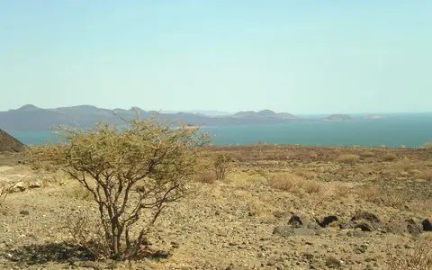

One lake across a moving international shore
Lake Turkana is the accepted modern name; Kenya's 2025 statutory fisheries plan notes the former name Lake Rudolf. The same plan uses 3°34′59″N, 36°07′00″E as a lake reference. A World Lake Database record places the feature within 2°23′–4°35′N and 35°50′–36°44′E, a more useful indication of its elongated geographic spread than any single point.[1][3]
Most open water is in Kenya, between Turkana County on the west and Marsabit County on the east. At the north, the dynamic Omo delta spans Kenya and Ethiopia, so the international boundary crosses a changing complex of channels, wetlands, sediment bars, and shallow water rather than a fixed physical edge. This record covers that lake-and-delta margin, not the whole Omo basin or either county.[4]
Omo delta north, volcanic barrier south
The Omo enters from the Ethiopian Highlands at the lake's northern end. Along the eastern side are Koobi Fora and Allia Bay, with the Huri Hills and Mount Kulal volcanic terrain farther east. Ferguson's Gulf and the Turkwel and Kerio deltas interrupt the western shore. At the south, the Barrier volcanic complex separates the Turkana lake basin from the lower Suguta trough.[2][5][6]
North, Central, and South islands form an axial chain within the lake. They are volcanic centers, not erosional remnants of one ridge: each sits near the center of a linked graben or half-graben segment. Around them, lava shores and rocky headlands contrast with the shallow, sediment-built Omo delta and with spits, beaches, and embayments on lower-gradient margins.[6][8]
Area and depth belong to a dated lake level
The principal 1972–75 bathymetric survey used the lake surface on 10 September 1972 as its zero contour and estimated that surface at 365.4 m above mean sea level. A later geodetic survey tied the same zero to 365.4 m in the Earth Gravitational Model 2008. At that stage the lake was measured as 257 km long, 13–44 km wide, about 7,560 km² in area, 31 m deep on average, and 114 m at its deepest point. Its estimated volume was 237–238 km³.[2][10]
The 1985–88 limnological record describes a lake about 5 m lower and reports 6,750 km², 203.6 km³, 30.2 m mean depth, and 109 m maximum depth. Those figures do not contradict the 1972 survey: the later shoreline and depth zero were lower. The lake's shallow northern and marginal shelves lose much more area than its steep-sided southern basin for the same vertical fall, so an undated area or depth is incomplete.[2][3]
7,560 km²
Survey shoreline later tied to 365.4 m EGM2008; about 257 km long and up to 44 km wide.
6,750 km²
Lower-stage limnological record with a 360.4 m surface reference.
Stage controls extent
Neither mapped area should be presented as a timeless modern shoreline.
Linked half-grabens in an active rift
Seismic and gravity studies show that the lake overlies a chain of north-trending half-grabens—tilted crustal blocks dropped mainly along one major normal fault—with border faults alternating from one side of the rift to the other. The geological basins deepen northward and contain as much as about 4 km of sediment. That is thickness of basin fill beneath the lake, not water depth; the deepest present water, about 110–114 m at the 1972 survey stage, is in the southern section.[4][5]
Rifting created accommodation space while rivers supplied sand, silt, and clay and volcanoes supplied lava and ash. Faulting and subsidence have focused within the modern lake-basin segments since the mid-Pliocene, and Quaternary magmatism built the three axial island centers. South Island remains part of a zone of focused faulting and magmatic intrusion, evidence that basin formation is an ongoing tectonic process rather than a single ancient event.[5][6]
Highland inflow balanced by lake-surface evaporation
The approximately 130,860-km² drainage basin is much larger than the lake. The perennial Omo drains the Ethiopian Highlands and is historically estimated to deliver about 90% of total input, although direct discharge measurement near the delta is difficult. The Turkwel and Kerio approach from the west: their upper reaches are perennial, but their lower courses across semi-arid plains are episodic. Short littoral channels add brief local floods after storms.[3][4][7]
No river leaves the modern lake, and chemical-balance work finds no major groundwater leakage; recent isotope research therefore treats evaporation as the water loss. Salts delivered by rivers and weathering remain behind as water evaporates. A 1983 mass-balance study measured pH 9.2 and total dissolved solids of about 2,500 mg/L, a dated chemical snapshot that supports “alkaline and moderately saline” rather than a comparison with seawater.[4][9]
Scant local rain, remote runoff, and the Turkana Jet
Rainfall is scant and spatially variable. A 2024 study summarizes Turkana Basin precipitation as less than 200 mm/year in its abstract but gives 200–300 mm/year for the broader basin in its introduction; the World Lake Database's single-station 1975 series for Lodwar totals 178 mm. Because these describe different scopes and periods, roughly 200 mm/year is more defensible than one precise timeless mean. Rain falls mainly in the boreal-spring “long rains” and autumn “short rains,” while mean annual air temperature is around 30°C.[3][4]
The Turkana low-level jet carries Indian Ocean air northwest through the low-elevation channel toward South Sudan. It produces strong southeasterly winds; when strongest in boreal summer, it suppresses local rain, while the two rainy seasons occur during weaker transition periods. Wind drives waves, currents, and vertical mixing. The World Lake Database calls Turkana monomictic—mixing through the full depth once in a typical year—and records temporary stratification in early 1987 and 1988; a 1983 study describes the northern basin as polymictic, or mixing repeatedly. The safest description is frequent wind mixing with seasonal stratification, not one unqualified whole-lake class.[3][4][9]
Vertical shifts redraw shallow margins
Satellite altimetry and water-balance modeling for 1998–2009 found seasonal lake-level swings of about 1–2 m and a total range of roughly 4 m across the study period. A later satellite series recorded a rise of approximately 2 m between early 2020 and mid-2021, equivalent through the published level–volume curve to about 20 km³; the 2024 study explicitly says the reason was not yet well understood. These dated examples show variability, not a single long-term direction.[4][7]
Falling water exposes the low northern floor, lets the Omo cut farther into its delta, and shifts the river mouth south; rising water floods those same distributaries and shore flats. The 1970s bathymetric model places the drying threshold of shallow Ferguson's Gulf near 362.3 m on the EGM2008-linked surface reference, but delta growth and local sedimentation mean this should be read as a modeled historical threshold, not an immutable surveyed contour.[2][10]
River material reworked by rift winds
The Omo is both the main water source and the main sediment source. A 2023 Delft3D modeling study, checked against satellite imagery and measured deposition rates, found that wind waves resuspend much of the fine material first deposited near the river mouth. In the model, adding waves moved deposition from mainly within 10 km of the mouth in water shallower than 10 m to areas as far as about 30 km away and deeper than 30 m.[8]
Lake Turkana therefore links humid Ethiopian headwaters to an arid Kenyan rift sink: runoff moves south, sediment builds and repeatedly remakes the northern delta, and evaporation closes the water pathway. Compare this terminal system with the open drainage of Lake Victoria and with the much deeper fault basins of Lake Tanganyika and Lake Malawi.
Sources and measurement notes
- Republic of Kenya, The Lake Turkana Fisheries Management Plan, 2025, Legal Notice 49 of 2025 (28 February 2025; accessed 29 August 2026). Source for the accepted and former names, general map reference, transboundary basin scope, principal inflows, and the plan's 130,860-km² basin figure.
- Avery, S. T., Lake Turkana & the Lower Omo: Hydrological Impacts of Major Dam & Irrigation Developments, Volume I, University of Oxford African Studies Centre (October 2012), especially pp. 143–161. Source for the 1972–75 bathymetry and dated dimensions, 1988 datum difference, level–area–volume relationship, named shore features, Omo-delta response, Ferguson's Gulf threshold, and highland-to-lowland rainfall contrast.
- International Lake Environment Committee Foundation, World Lake Database: Lake Turkana (record based principally on the 1985–88 Lake Turkana Limnological Study; accessed 29 August 2026). Source for coordinate limits, 360.4 m reference elevation, 6,750-km² area, 203.6-km³ volume, 30.2 m mean and 109 m maximum depths, mixing classification, and climatic context.
- Saslaw, L. R. et al., “An Isotope Mass Balance Analysis of Evaporative Loss From Lake Turkana, Kenya Using δ18O and δD of Natural Waters”, Water Resources Research 60 (2024). Source for lake and delta location, terminal hydrology, historical Omo share, 2016–21 sampling, modern climate summary, Turkana Jet control, southern-basin depth, and the approximately 2 m rise observed in 2020–21.
- Emishaw, L. et al., “Development of Late Jurassic–Early Paleogene and Neogene–Quaternary Rifts Within the Turkana Depression, East Africa From Satellite Gravity Data”, Tectonics 38 (2019). Source for the north-trending half-graben chain, alternating border faults, sediment-fill depth, crustal structure, and the distinction between the Lake Turkana rift basin and adjacent rift zones.
- Rooney, T. O. et al., “Transition to magma-driven rifting in the South Turkana Basin, Kenya: Part 2”, Journal of the Geological Society 180 (published online 2022). Source for the axial volcanic centers, linked graben segments, Quaternary island volcanism, and active fault–magma localization at South Island.
- Velpuri, N. M. et al., “A multi-source satellite data approach for modelling Lake Turkana water level: calibration and validation using satellite altimetry data”, Hydrology and Earth System Sciences 16, 1–18 (2012). Source for the satellite-driven water-balance method, tributary behavior, closed drainage, and the 1998–2009 seasonal and total lake-level ranges.
- Zăinescu, F. et al., “The role of wind-wave related processes in redistributing river-derived terrigenous sediments in Lake Turkana: A modelling study”, Journal of Great Lakes Research 49, 368–386 (2023). Source for lake-sector morphology and the modeled effects of wind waves, currents, resuspension, and river input on sediment dispersal.
- Yuretich, R. F. and Cerling, T. E., “Hydrogeochemistry of Lake Turkana, Kenya: Mass balance and mineral reactions in an alkaline lake”, Geochimica et Cosmochimica Acta 47, 1099–1109 (1983). Source for the dated pH and total-dissolved-solids measurements, major-ion chemistry, Omo inflow share, and geochemical mass balance.
- Avery, S. T. and Tebbs, E. J., “Lake Turkana, major Omo River developments, associated hydrological cycle change and consequent lake physical and ecological change”, Journal of Great Lakes Research 44, 1164–1182 (2018). Source for the EGM2008 geodetic tie of the 1972 zero contour, bathymetric sectors, Ferguson's Gulf threshold, evaporation methods, tributary behavior, and modern water-balance interpretation.