.jpg)
One lake with more than one defensible area
“Lake Chad” is the English conventional name; the UK Permanent Committee on Geographical Names lists French Lac Tchad, Arabic Buḥayrat Tshād, and the variants Tsad and Tschad. Its 13°20′N, 14°00′E coordinate is a map reference for a lake whose physical center and margins move.[1] The conventional feature is shared by four countries, but a political lake sector is not proof that open water reaches that sector in every season or year.
Open water is only part of the lake. Satellite classifications can also map shallow water hidden by reeds and other aquatic vegetation. For the 2022 high stage, researchers measured 5,370 km² of open water but 18,800 km² of total inundation after vegetated water was included; the 2012–2022 mean annual maxima were about 4,310 km² and 17,500 km² under those two definitions.[2] An area without a date and surface-class definition is therefore incomplete.
A southern depression inside a much larger closed drainage system
The lake lies in the Central Sahel, immediately south of the Sahara. Chad occupies its eastern side; Cameroon's Far North reaches the south; Nigeria lies to the southwest and west; and Niger lies to the northwest. The present lake sits in the southern sub-basin. The much larger northern Chad Basin extends toward the Tibesti and Ennedi highlands but is now mainly desert and does not form part of the modern lake.[4]
The full topographic drainage basin is about 2.5 million km², yet most of it is hydrologically inactive under present climate. The active Chari–Logone catchment covers about 610,000 km² south of the lake. The rivers meet at N'Djamena and the combined Chari continues roughly 110 km northwest to the southern pool.[2] This river-to-lake corridor, rather than the far northern desert basin, supplies the recurring flood pulse.
A modern remnant on a long-lived sedimentary floor
The Chad Basin is an intracratonic sag basin: a broad depression within the African continental interior rather than a steep rift trough or volcanic crater. Neogene and Quaternary lake, river, and wind-blown deposits reach an estimated maximum thickness of about 500 m across its central part. Drilling near Bol records fine mud, diatom-rich lake sediment, and dune sand, evidence that lakes and deserts have repeatedly occupied the basin for millions of years.[4][5]
Modern Lake Chad should not be assigned the age of either the geological basin or one ancient highstand. During the wetter middle Holocene, Lake Mega-Chad spread across more than 350,000 km²; geomorphic and sediment evidence places its highest sustained levels roughly 8,500–6,300 calibrated years before 1950. Its shore stood near 320–325 m and extended far into the now-dry northern basin. As that humid phase ended, the lake contracted into lower southern ground.[4]
Two pools, a sand threshold, and drowned dunes
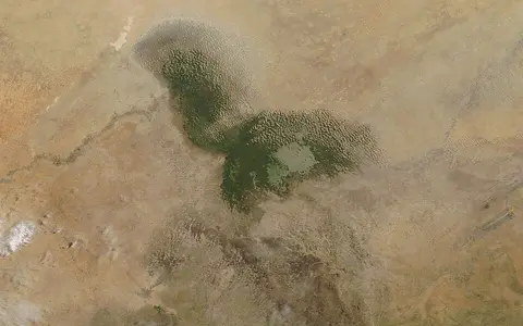
The Chari enters the southern pool, the most persistent open-water part of the modern lake. To its north, the Great Barrier is an east–west belt of sand and vegetation that acts as a sill: the southern pool must rise high enough for water to cross into the lower northern pool. A 2024 synthesis gives representative elevations of 278.2 m for the southern pool, 279.3 m for the barrier, and 275.3 m for the northern pool. Its main text does not identify a vertical datum, so those values are most useful for their relative geometry, not as surveyed shoreline heights.[2]
East of the pools, the archipelago is a partly inundated dune field. Ridges form long islands while water occupies the swales between them; connection changes as lake stage rises and falls. Across all three sectors, a depth of less than 3 m and a very gentle floor allow a small vertical change to move the wetland edge over thousands of square kilometres.[3][4]
Persistent pool
Direct Chari inflow maintains the main body of open water and raises it toward the Great Barrier.
Intermittent pool
Flooding depends on spill across the barrier plus smaller Komadugu Yobe input from the west.
Dune archipelago
Sand ridges, channels, and vegetated shallows produce a broad edge rather than one clean shoreline.
Southern river water balanced by evaporation and seepage
The Chari and Logone drain humid and seasonally wet country in southern Chad, the Central African Republic, and Cameroon before joining at N'Djamena. A 2024 synthesis assigns the system up to 82% of Lake Chad's supply; a 2020 satellite-hydrology study reports more than 90%. Because the studies do not state the same accounting period and balance definition, “dominant inflow” is more dependable than one timeless percentage.[2][3] The Komadugu Yobe contributes from the west, while rain falls directly on the lake.
Present-day Lake Chad has no normal river outlet to the sea. Annual evaporation is estimated at more than 2,000 mm, and water also seeps into the surrounding Quaternary phreatic aquifer. Exchange with that shallow aquifer helps remove and redistribute dissolved material, one reason the lake remains fresh despite intense evaporation.[3] At exceptional stages above about 285 m, water can enter the normally dry Bahr el Ghazal spillway toward the northern basin; that rare overflow is not a normal ocean outlet.[4]
Monsoon rain arrives at the lake after a river delay
Rainfall decreases sharply from the Sudanian headwaters northward to the semi-arid lake. Across the active southern basin, the wet season generally runs from May to October, with most rain in July and August. Runoff then travels through the Chari–Logone network, so lake stage lags rainfall and upstream river peaks. In 2022 the lake began rising in mid-August and reached its maximum on 16 December, about a month after the Chari peak at N'Djamena.[2]
That 2022 maximum reached 281.36 m in the published multi-satellite altimetry series; the paper does not name the vertical datum in its main methods. The same event produced the 5,370 km² open-water and 18,800 km² total-inundation estimates above.[2] Wind, evaporation, vegetation, the barrier threshold, and year-to-year river discharge then control how long water remains in the northern pool and among the archipelago channels.
The 1970s–1980s collapse is not the whole modern record
Lake Chad did contract dramatically after the wet 1950s–1960s as severe Sahel drought reduced river inflow and split the lake into its modern pools. The familiar claim that it “lost 90%” describes a particular high-to-low historical comparison and is often repeated without stating whether vegetation-covered water was included. It should not be used as a fixed present-day area.[3]
MODIS observations for 2001–2018 found the southern pool broadly stable while open water in the northern pool decreased slightly and sometimes disappeared in the dry season. Updated observations through 2022 recorded a large high-water year rather than a one-way decline.[2][3] The defensible atlas description is therefore a shallow, climatically responsive lake with strong seasonal and multi-decadal variability—not a lake with one permanent modern outline.
Sources and measurement notes
- United Kingdom Permanent Committee on Geographical Names, Chad: Toponymic Factfile, p. 8 (July 2021; accessed 29 August 2026). Source for the recommended and conventional English name, French and Arabic forms, variants, four-country attribution, feature type, and 13°20′N, 14°00′E map reference. The factfile does not describe that point as a centroid.
- Sylvestre, F. et al., “Strengthening of the hydrological cycle in the Lake Chad Basin under current climate change”, Scientific Reports 14, 24639 (2024). Source for basin and active-catchment areas, river geography, seasonal climate, pool/barrier geometry, depth, evaporation, the 2001–2022 MODIS method, the December 2022 lake level, and open-water versus vegetation-inclusive extent. The article's main text does not specify the vertical datum for its published elevations.
- Pham-Duc, B. et al., “The Lake Chad hydrology under current climate change”, Scientific Reports 10, 5498 (2020). Source for the 2001–2018 pool trends, the distinction between open water and inundated vegetation, Great Barrier and archipelago descriptions, shallow-aquifer exchange, freshwater regulation, and the caution against treating the drought-era contraction as continuing disappearance.
- Schuster, M. et al., “Chad Basin: Paleoenvironments of the Sahara since the Late Miocene”, Comptes Rendus Geoscience 341, 603–611 (2009). Source for intracratonic-basin geology, sediment thickness, northern and southern sub-basins, flat-floor sensitivity, Bahr el Ghazal overflow, and the extent, elevation, and dated highstand interval of Holocene Lake Mega-Chad.
- Sylvestre, F. et al., “The Lake CHAd Deep DRILLing project (CHADRILL)—targeting ~10 million years of environmental and climate change in Africa”, Scientific Drilling 24, 71–78 (2018). Source for the long-term sedimentary setting, approximately 3 m measured depth in 2012, monsoon control, and the Bol borehole sequence of lacustrine mud, diatom-rich deposits, and dune sand.