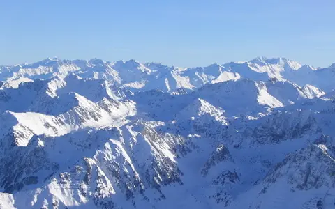

The physical chain, not every Pyrenean region
Pyrenees is the accepted English name; regional forms include Pyrénées in French, Pirineos in Spanish, and Pirineus in Catalan. This page covers the geographical mountain chain from the Atlantic end to Cap de Creus, including the Axial Zone and the flanking North and South Pyrenean belts. It does not treat the wider Pyrenean–Cantabrian geological continuation, the entire Ebro or Garonne watershed, or the much larger administrative territory of the Working Community of the Pyrenees as though each had the same boundary. (Working Community of the Pyrenees; Dielforder and others, 2019)
A recent transboundary hydrological study used an approximately 400 km length and a maximum central width near 150 km. These are rounded dimensions tied to that study area. Western limits vary among geographical and geological definitions because Pyrenean structures continue into the Basque–Cantabrian belt and beneath the Bay of Biscay; a single centre coordinate would therefore imply a precision the range does not possess. (Beguería and others, 2026)
A high central spine between two forelands
The highest relief is concentrated in central massifs including Vignemale, Monte Perdido, Posets, and Maladeta. Aneto stands in the Maladeta massif in Huesca, Spain. The Spanish National Geographic Institute's geodetic record gives the pillar-head position as 42°37′51.81877″ N, 0°39′23.93298″ E in ETRS89 and its mean-sea-level height as 3,404.039 m; the atlas rounds that measured height to 3,404 m. The record describes the mark at the highest rocky part of the peak, so it should not be confused with a coordinate or mean elevation for the whole range. (IGN geodetic record, Aneto 2022)
Relief falls toward the humid western hills and toward the eastern Albères above the Mediterranean, but the chain is not one continuous crest. Transverse valleys, limestone plateaus, subsidiary ridges, and interior depressions interrupt it. To the north, the mountain front meets the Aquitaine foreland; to the south, folded foothill ranges and the South Pyrenean foreland descend toward the Ebro Basin. The geological fronts and the topographic edges merge gradually into these forelands rather than ending at cadastral lines. (Geological Survey of Spain, MAGNA sheet 210 memoir)
Rift inversion followed by continental collision
Before the mountains rose, extension thinned the crust between Iberia and Europe, especially during the Early Cretaceous. Convergence then inverted those rift basins: faults that had accommodated extension were reactivated under compression. Deformation began by about 84 million years ago in the Late Cretaceous; continental collision and underthrusting became dominant after the Paleocene, and convergence continued into the early Miocene. “Fold mountains” is therefore incomplete shorthand—the belt records rifting, inversion, thrusting, crustal stacking, metamorphism, uplift, and erosion. (Dielforder and others, 2019)
In cross-section the range is a double-vergent orogenic wedge: rock packages were driven outward on thrust faults toward both forelands. Paleozoic granite, gneiss, schist, and other basement rocks crop out in the Axial Zone. Mesozoic and Cenozoic sedimentary rocks form much of the North and South Pyrenean belts, while the North Pyrenean Fault follows an inherited internal boundary. South-directed structures extend farther across the Iberian side than the narrower north-directed belt does toward Aquitaine. (IGME–BRGM, Geological Map of the Pyrenees, 1:400,000)
Axial Zone
Older continental basement is exposed in the structurally uplifted interior of much of the chain.
Fold-and-thrust belts
Sedimentary cover was shortened and carried outward over the Aquitaine and Ebro forelands.
North Pyrenean Fault
An inherited internal fault zone records the former Iberia–Europe plate boundary.
Valley ice and soluble rock left different signatures
Pleistocene glaciers occupied the major high valleys, leaving moraine ridges, polished bedrock, overdeepened valley floors, and cirques—amphitheatre-shaped hollows eroded around glacier heads. Their chronology is not reducible to one range-wide maximum. A review of moraine, lake-sediment, and cosmogenic-nuclide evidence placed the last cycle's maximum ice extent in Marine Isotope Stage 4, before the global Last Glacial Maximum, followed by a substantial but geographically uneven readvance during the global maximum. Main trunk glaciers then retreated into upper valleys before the Late-glacial interval. The exact western extent and correlations among valleys remain less certain than the general sequence. (Delmas, 2015)
Carbonate belts respond differently. In karst, slightly acidic water enlarges fractures in soluble limestone, routing part of the drainage through dolines, shafts, caves, and springs. The Larra system in the western South Pyrenean belt is a mapped example with dense limestone pavement, sinkholes, and vertical shafts. In the central Mont Perdu limestone massif, deeply cut canyons on the southern side contrast with large cirque walls on the northern side. These are specific carbonate sectors, not evidence that the entire range is limestone. (IGME Geological Site Inventory: Larra karst; UNESCO: Pyrénées–Mont Perdu)
Small glaciers measured on dated imagery
A 2024 study remapped the remaining ice using aerial orthophotos and drone orthomosaics at 0.20–0.25 m resolution. It measured 143.2 ± 1.8 ha (1.432 ± 0.018 km²) of glacierized area in 15 glaciers in 2023; eight of the 23 ice bodies classified as glaciers in 2020 had become ice patches under the study's movement, crevasse, fragmentation, and 2 ha size criteria. The authors also revised the 2011 area to 302.4 ha after snow-free imagery improved earlier outlines. On that revised baseline, mapped glacier area fell 52.6% from 2011 to 2023. These values are method-defined inventory snapshots, not a current ice-area estimate, and should not be combined with unrevised outlines. (Izagirre and others, 2024)
Aneto Glacier illustrates why area and thickness must be dated separately. A 2022 survey mapped 48.1 ha (0.481 km²) of ice and estimated a mean autumn thickness of 11.9 m from ground-penetrating radar, lidar, historical photographs, and drone photogrammetry. Between 1981 and 2022 its mapped area decreased by 64.7%. Those measurements describe Aneto Glacier, not the summit elevation and not the combined ice of the range. (Vidaller and others, 2023)
A divide crossed by rivers and borders
Western catchments such as the Bidasoa, Oria, and Urumea reach the Bay of Biscay directly. Farther east, Pyrenean headwaters enter the Adour and Garonne systems and ultimately the Atlantic. South-flowing headwaters feed the Aragón, Gállego, Cinca–Ésera, and Segre systems of the Ebro, which reaches the Mediterranean; eastern coastal rivers include the Aude, Agly, Têt, Tech, Muga, Ter, and Llobregat. This is a two-sea drainage pattern with several major receiving basins, not a simple split into north-flowing and south-flowing water. (Beguería and others, 2026; Pyrenean Climate Change Observatory, 2018)
Nor does the political boundary consistently follow the hydrological divide. Spain's Val d'Aran contains the upper Garona, which continues into France as the Garonne. Conversely, the upper Segre and tributary headwaters occur in France, while most Andorran drainage leaves through the Gran Valira toward the Segre and Ebro; a smaller eastern Andorran sector drains toward the Ariège and Garonne. Official basin documents therefore treat several of these headwaters as transboundary systems. (Ebro River Basin Authority, transboundary assessment for the 2022–2027 plan; Government of Andorra water-basin description)
Seasonal snow is the important short-term store. A two-model reconstruction for the 1981–2010 baseline found that snowmelt sustained spring and early-summer flow in high central and western catchments. Modern glaciers, by contrast, are too small to supply a comparable range-wide water reserve. The timing and magnitude of runoff vary with elevation, snowline, catchment exposure, rainfall, and year, so a discharge figure from one river cannot stand for the whole chain. (Beguería and others, 2026)
Ocean source, elevation, and exposure
Atlantic air supplies frequent moisture to the west and to exposed northern and western slopes; Mediterranean circulation matters more toward the eastern end. Forced ascent over the relief cools moist air and promotes rain or snow, while descending lee-side air warms and dries. Elevation lowers temperature, and slope aspect changes solar exposure and snow persistence. These controls create north–south and west–east gradients as well as dry interior valleys; “Atlantic west, Mediterranean east” is a useful first orientation but not a complete climate map.
For a concrete baseline, the 2026 transboundary water-balance study combined French and Spanish SAFRAN analyses on a 2.5 × 2.5 km grid for 1981–2010. Its modeled annual precipitation exceeded 2,000 mm in Atlantic headwaters and fell below 1,000 mm in southern and eastern foothills. These are spatially modeled period averages, not station normals or timeless thresholds. Météo-France's separate 1991–2020 station normal of 1,962 mm at Iraty Orgambide (1,427 m) provides an observed western example, but should not be generalized to other elevations or sectors. (Beguería and others, 2026; Météo-France, 1991–2020 precipitation normals)
From mountain mass to adjacent basins
Rivers carry water and eroded sediment away from the range into the Aquitaine and Ebro forelands and into smaller coastal plains at both ends. Glacially overdeepened basins hold sediment and groundwater beneath some valley floors; carbonate aquifers route water through fissures and springs; steep non-karst catchments respond more directly through surface channels. The physical chain therefore connects high massifs to distant lowlands without making the surrounding drainage basins part of the mountain range itself.
Westward, Pyrenean structures continue into the Cantabrian Mountains, although that wider geological belt is outside this page's geographical scope. Use the mountain hub to compare the Pyrenees with other collisional ranges, including the Alps, without assuming that their glacier histories, basin geometry, or natural boundaries are directly equivalent.
Data sources and publications
- Beguería, S., and others. “Water balance components of the Pyrenees: A 30-year modelling study in a transboundary context,” Journal of Hydrology: Regional Studies 64, 103195 (2026). Approximate study-area extent; catchments; 1981–2010 meteorological grid, precipitation gradients, and snowmelt timing; model uncertainty.
- Instituto Geográfico Nacional, Spain. Reseña Vértice Geodésico 18058: Aneto 2022, record dated 15 August 2026. ETRS89 coordinates, GNSS method, monument information, and 3,404.039 m mean-sea-level height at the pillar head.
- Instituto Geológico y Minero de España and Bureau de Recherches Géologiques et Minières. Geological Map of the Pyrenees, 1:400,000 (2009), with geological cross-section and companion Quaternary map. Structural zones, rock distribution, foreland setting, and glacial imprint.
- Dielforder, A., Frasca, G., Brune, S., and Ford, M. “Formation of the Iberian-European Convergent Plate Boundary Fault and Its Effect on Intraplate Deformation in Central Europe,” Geochemistry, Geophysics, Geosystems 20 (2019), 2395–2417. Rift inversion, collision timing, double vergence, Axial Zone, and wider geological continuations.
- Delmas, M. “The last maximum ice extent and subsequent deglaciation of the Pyrenees: an overview of recent research,” Cuadernos de Investigación Geográfica 41 (2015), 359–387. Moraine evidence, dating methods, maximum-extent interpretation, readvance, and deglaciation uncertainty.
- Izagirre, E., Revuelto, J., Vidaller, I., and others. “Pyrenean glaciers are disappearing fast: state of the glaciers after the extreme mass losses in 2022 and 2023,” Regional Environmental Change 24, 172 (2024). Revised 2011 and 2020 outlines, 2023 glacier count and area with uncertainty, classification criteria, and reasons earlier inventories differ.
- Vidaller, I., and others. “The Aneto glacier's (Central Pyrenees) evolution from 1981 to 2022,” The Cryosphere 17 (2023), 3177–3192. Dated glacier area, lidar and photogrammetric change, ground-penetrating-radar thickness, and stated uncertainty.
- UNESCO World Heritage Centre. Pyrénées–Mont Perdu (accessed 30 August 2026). Transboundary limestone massif, south-side canyons, north-side cirques, and local maritime–Mediterranean contrast.
- Instituto Geológico y Minero de España. Spanish Inventory of Geological Sites: PS010, Larra Karst System (accessed 30 August 2026). Geological unit, elevation range, limestone pavements, dolines, shafts, caves, and hydrogeological significance.
- Confederación Hidrográfica del Ebro. Transboundary Effects Assessment for the Ebro River Basin Management Plan, third cycle 2022–2027. Garona headwaters in Spain and Ebro tributary headwaters in France and Andorra.
- Pyrenean Climate Change Observatory. Climate Change in the Pyrenees: Impacts, Vulnerabilities and Adaptation (2018), section 2.6. Headwater basins, snow as seasonal storage, and limits of catchment-scale generalization.
- Météo-France. Où pleut-il le plus en France hexagonale ?, updated 24 May 2024. Observed 1991–2020 annual precipitation normal and station elevation for Iraty Orgambide.