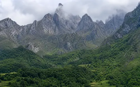
One mountain system, several possible edges
Cantabrian Mountains is the accepted English name and Cordillera Cantábrica the Spanish name. This page covers the physical mountain system from the Galician transition through the Asturian massif and Picos de Europa to the Basque-Cantabrian transition toward the Pyrenees. The Picos de Europa are one high limestone group within that system. The geological Cantabrian Zone is a Paleozoic structural domain, not a synonym for the entire modern range, and the range is much wider than the autonomous community of Cantabria.
No single surveyed polygon fixes the natural boundary where adjoining uplands merge. A geological overview describes a chain of more than 400 km from Galicia to the Pyrenees; a whole-range glacial review uses 460 km and a study envelope of roughly 42–43°N, 7–2°W, from Queixa–Invernadoiro to the Basque Mountains. These are different research scopes, not contradictory tape measurements, so the stat card retains the more conservative rounded length. (Alonso, Pulgar and Pedreira, 2007; Rodríguez-Rodríguez and others, 2015)
Spain's 2005 national geographical tables list Torre Cerredo at 2,648 m. The IGN's separate Torrecerredo geodetic-station sheet places the marker at 43°11′51.935″N, 4°51′10.323″W in ETRS89 and gives 2,649.227 m above mean sea level at the base of its pillar. One value is a published named-summit elevation and the other describes a specific benchmark point; they are therefore reported separately rather than averaged. (IGN geographical tables, 2nd ed.; IGN station 5601)
Coast, mountain front, and two foreland basins
The exposed land range runs roughly parallel to the Cantabrian coast. Geological structures continue beneath the continental shelf and slope of the Bay of Biscay, but this page stops at the terrestrial mountain system. On the south, the Duero and Ebro foreland basins lie in front of the Alpine mountain front; their sediment fills locally exceed 3,500 m, recording erosion from the rising range. (Alonso, Pulgar and Pedreira, 2007)
The central Picos de Europa stand only about 20 km from the sea, a local value that should not be applied to the entire chain. Coast-facing rivers therefore descend toward a nearby base level and have cut gorges and short transverse valleys. Geological mapping attributes continued southward migration of the drainage divide to headward erosion on this northern flank. South-flowing headwaters instead enter the elevated Duero foreland or, farther east, the Ebro system. (Serrano and others, 2013; Alonso, Pulgar and Pedreira, 2007)
Variscan inheritance reworked by Alpine collision
Much of the western and central basement was folded and thrust during the late Paleozoic Variscan orogeny. Later extension opened Mesozoic basins along northern Iberia. During Cenozoic convergence between Iberia and Europe, broadly north-south compression inverted some of those faults and reactivated older structures. A thrust is a low-angle fault that carries one rock mass over another; thrusting and associated folding produced much of the present relief. The main uplift of the range is placed between the middle Eocene and Miocene rather than in the Paleozoic. (Pulgar and others, 1999; Alonso, Pulgar and Pedreira, 2007)
The structure changes along strike. In the central Asturian massif, a broad block of Paleozoic basement was lifted above the Duero Basin on a crustal-scale thrust rooted in the middle crust. In the eastern Basque-Cantabrian sector, folds developed in thicker Mesozoic sedimentary cover above thrust ramps. Carbonate units form resistant high blocks and karst, while shale, sandstone, quartzite, and other siliciclastic rocks produce different ridge and valley patterns. The range is therefore neither one rock type nor one continuous fold.
Variscan basement
Paleozoic folds and thrusts supplied structures later tilted or reactivated.
Alpine uplift
Cenozoic convergence raised the basement and folded younger cover.
Duero and Ebro basins
Sediment eroded from the range accumulated beside its southern tectonic front.
Surface relief and hidden drainage
The Picos de Europa are a distinctive central subrange, not a model for every Cantabrian massif. There, a structurally repeated Carboniferous limestone succession more than 2 km thick supports cliffs, towers, dolines, shafts, caves, and enclosed basins. A 2019 hydrogeological study found that direct infiltration through exposed karst is the main recharge process and that low-permeability siliciclastic layers steer much of the regional groundwater north toward springs. Surface streams can therefore disappear underground, and a mapped surface catchment may not describe the full groundwater route. (Meléndez, Ballesteros and Jiménez-Sánchez, 2019)
Pleistocene ice also reshaped the range, leaving cirques, troughs, moraines, rock glaciers, and lake or peat-filled hollows. A 2015 synthesis reconstructed about 3,150 km² of ice at the range's maximum stage and placed that stage at a minimum age of roughly 36–45 ka, followed by a second advance at about 19–23 ka. Those are reconstructed areas and age ranges, not modern measurements. Deglaciation accelerated after about 18 ka; four small glaciers returned in the Picos de Europa during the Little Ice Age and disappeared by the end of the nineteenth century. No active glaciers remain, although seasonal snow and frost continue to modify the highest ground. (Rodríguez-Rodríguez and others, 2015; Serrano and others, 2015)
Three outward routes from the range
North of the main divide, the Eo, Navia, Esva, Nalón, Sella, Deva, Nansa, Saja, Pas, Miera, Asón, Nervión, and other mainly short basins drain directly to the Cantabrian Sea. Their individual catchments are separate systems rather than tributaries of one “Cantabrian River.” The official basin authority's list also shows that the eastern transition continues through the Oria, Urumea, and Bidasoa basins. (Confederación Hidrográfica del Cantábrico)
On the southern side, rivers including the Esla, Carrión, and Pisuerga carry headwater runoff into the Duero, which crosses the interior and Portugal to the Atlantic. Farther east, the Ebro descends southeast from the Cantabrian Mountains to the Mediterranean. The crest is therefore both an Atlantic–Mediterranean divide and, within the Atlantic drainage, a divide between direct Cantabrian catchments and the long Duero route. (Confederación Hidrográfica del Duero; Confederación Hidrográfica del Ebro)
Karst complicates that surface pattern locally. In the Picos de Europa, the Sella, Deva, and Cares cut the principal valleys, while tracer studies and spring locations indicate predominantly northward regional groundwater flow with local deviations controlled by bedding, thrusts, and low-permeability barriers. A topographic divide is therefore dependable for surface flow but not automatically for every underground conduit. (Meléndez, Ballesteros and Jiménez-Sánchez, 2019)
Atlantic ascent, elevation, and interior shelter
Moist Atlantic air commonly rises over the seaward slopes, cooling and producing orographic rain or snow. The crest and interior-facing valleys are more sheltered, but the contrast varies with elevation, exposure, and position along the range. A whole-range synthesis reported modeled mean annual precipitation bands of roughly 1,000–1,100 mm at the coast, 1,600–2,000 mm near the northern mountain edge, and 600–700 mm on the southern side. These are regional bands from the cited climate surfaces, not a single range average or a current station normal. (Rodríguez-Rodríguez and others, 2015)
The official Iberian Climate Atlas provides an independent mapped baseline from station observations for the 1971–2000 climate-normal period. Its dated normal should not be presented as present-day weather or as proof that every northern slope is wetter than every southern valley. Within the Picos de Europa alone, a 2019 study reported annual precipitation of 1,000–1,800 mm but only 670–700 mm in some eastern valleys. Winter snow stores water temporarily at high elevation, while rapid thaws and karst infiltration make the timing and route of runoff strongly local. (AEMET and Instituto de Meteorologia, Iberian Climate Atlas; Meléndez, Ballesteros and Jiménez-Sánchez, 2019)
A transition, not a hard-ended ridge
Westward, Cantabrian relief merges with the uplands of Galicia and León; eastward, the Basque-Cantabrian mountains connect structurally and topographically toward the Pyrenees. Published endpoints vary because those transitions are gradual. The range is nevertheless distinct from the Duero and Ebro sedimentary basins at its southern front and from the offshore continuation of the North Iberian structures beneath the Bay of Biscay.
Use the mountain hub to compare this coastal range with other tectonic and glaciated systems, and the Pyrenees record for the higher range to the east. The connection is geological and geographic; it does not make the Cantabrian Mountains merely a western administrative sector of the Pyrenees.
Data sources and publications
- Alonso, J. L., Pulgar, J. A., and Pedreira, D. “El relieve de la Cordillera Cantábrica / The Relief of the Cantabrian Mountains”, Enseñanza de las Ciencias de la Tierra 15.2 (2007), 151–163. Geographic scope, foreland basins, collision, crustal structure, and erosion.
- Instituto Geográfico Nacional. Tablas de datos geográficos, 2nd ed. (2005), mountain table. Conventional 2,648 m Torre Cerredo elevation.
- Instituto Geográfico Nacional. Reseña Vértice Geodésico 5601: Torrecerredo, coordinate calculation dated 1 November 2009; location map dated 1 August 2026. ETRS89 coordinates and 2,649.227 m mean-sea-level elevation at the pillar base.
- Pulgar, J. A., Alonso, J. L., Espina, R. G., and Marín, J. A. “La deformación alpina en el basamento varisco de la Zona Cantábrica”, Trabajos de Geología 21 (1999), 283–295. Reactivation of Variscan folds, thrusts, and Mesozoic extensional faults.
- Rodríguez-Rodríguez, L., Jiménez-Sánchez, M., Domínguez-Cuesta, M. J., and Aranburu, A. “Research history on glacial geomorphology and geochronology of the Cantabrian Mountains, north Iberia”, Quaternary International 364 (2015), 6–21. 460 km study scope, coordinate envelope, reconstructed maximum ice area and ages, and regional precipitation bands.
- Serrano, E., González-Trueba, J. J., Pellitero, R., González-García, M., and Gómez-Lende, M. “Quaternary glacial evolution in the Central Cantabrian Mountains (Northern Spain)”, Geomorphology 196 (2013), 65–82. Central massifs, Picos de Europa setting, summit elevation, and glacial chronology.
- Serrano, E., Gómez-Lende, M., Pellitero, R., and González Trueba, J. J. “Deglaciation in the Cantabrian Mountains: pattern and evolution”, Cuadernos de Investigación Geográfica 41.2 (2015), 389–408. Deglaciation sequence and disappearance of Little Ice Age glaciers.
- Meléndez, M., Ballesteros, D., and Jiménez-Sánchez, M. “Hydrogeology of the Picos de Europa National Park (northern Spain)”, Boletín Geológico y Minero 130.4 (2019), 593–614. Limestone thickness, karst recharge, groundwater direction, river network, and local precipitation.
- Agencia Estatal de Meteorología and Instituto de Meteorologia. Iberian Climate Atlas (2011; accessed 30 August 2026). Station-based temperature and precipitation maps for the 1971–2000 normal period.
- Spanish basin authorities: Confederación Hidrográfica del Cantábrico, basin scope and principal catchments; Confederación Hidrográfica del Duero, physical basin setting; and Confederación Hidrográfica del Ebro, basin course (accessed 30 August 2026).