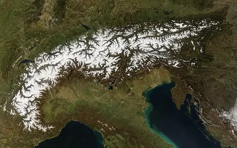

A physical arc, not one surveyed polygon
Alps is the accepted English name; European Alps distinguishes the range from similarly named mountains elsewhere. The corresponding regional names include Alpes in French, Alpi in Italian, Alpen in German, and Alpe in Slovene. This page covers the connected European mountain system, including its western, central, eastern, and southern sectors. It does not use “Alpine” as a synonym for every high-elevation habitat or for the much wider Alpine–Himalayan orogenic belt.
The arc crosses or touches Monaco, France, Italy, Switzerland, Liechtenstein, Germany, Austria, and Slovenia. A natural mountain front merges locally into foothills, so the range has no single authoritative centroid or cadastral edge. The Alpine Convention's policy perimeter provides a consistent comparison area of 190,717 km², about 1,200 km long and at most 300 km wide, but that administrative perimeter should not be presented as the exact area of exposed mountain relief. (Permanent Secretariat of the Alpine Convention)
From the Mediterranean bend to the eastern foothills
At the southwestern end, the Maritime and Ligurian Alps rise behind the Mediterranean coast. The arc turns north through the Cottian and Graian Alps, then bends east around the high massifs of Mont Blanc and the Pennine and Bernese Alps. Farther east it broadens through the Swiss, Italian, German, Austrian, and Slovenian Alps before descending toward the Vienna and Pannonian basins. The North Alpine Foreland, including the Molasse Basin, lies outside the mountain front; the Po Basin borders the inner side of the arc to the south. (Schlunegger and Kissling, 2015)
The Alps are not a single crest. Crystalline massifs, limestone ranges, parallel ridges, high plateaus, deep longitudinal valleys, and cross-range gorges produce several competing divides. Mont Blanc rises between the Chamonix and Aosta valleys in the western Alps. A Franco-Italian scientific mission reported a maximum snow-and-ice surface elevation of 4,807.3 m in 2025 using drones, remote sensing, and ground-penetrating radar; the Haute-Savoie survey had measured 4,805.59 m in 2023. These results describe different dated configurations of a wind-shaped summit cap and should not be averaged or mistaken for a fixed bedrock elevation. (Autonomous Region of Aosta Valley, 2025 mission; Ordre des géomètres-experts, 2023 measurement; Vincent and others, 2007)
Ocean closure, collision, and crustal stacking
The Alps record the closing of the Alpine Tethys, a set of former ocean basins between Europe and the Adriatic microplate. Oceanic crust and continental-margin rocks began to descend by subduction during the Cretaceous. From the Eocene onward, continued convergence brought continental crust into the collision zone. Compression folded rocks and drove large slices called nappes—thrust sheets transported far from where their rocks formed—over one another. This is why “fold mountain” is only a partial classification: subduction, thrusting, metamorphism, faulting, and uplift all contributed to the range. (Handy and others, 2010)
The resulting belt contains European basement and sedimentary cover, metamorphosed remnants of the former ocean and its margins, and Adriatic-derived units. Granite and gneiss form high external massifs such as Mont Blanc and the Aar massif; limestone and dolomite dominate broad sectors of the Northern and Southern Limestone Alps. The Periadriatic fault system separates much of the main Alpine stack from the south-verging Southern Alps. Erosion carried detritus north into the Molasse foreland and south into the Po system while the crustal load flexed the adjoining basins. (Schlunegger and Kissling, 2015)
Alpine Tethys
Fragments of oceanic crust and continental margins survive inside the collisional stack.
Nappes and massifs
Thrust sheets surround and overlie uplifted blocks of older continental basement.
Molasse and Po basins
Flexural basins beside the range received large volumes of sediment eroded from Alpine relief.
Repeated ice flow enlarged an older river network
Quaternary glaciers repeatedly joined into trunk streams that flowed along major valleys and spread onto the forelands. Abrasion, quarrying, and pressurized meltwater widened valleys, steepened headwalls, and cut closed bedrock depressions below the former down-valley gradient. An overdeepening is one of these basins, excavated below its outlet threshold. After the ice withdrew, some overdeepenings filled with sediment and others held lakes in Alpine valleys and the adjoining foreland. (Magrani and others, 2020)
Cirques at valley heads, arêtes between them, hanging tributary valleys, moraines, and broad trough floors are therefore parts of one connected glacial system rather than a checklist of isolated forms. Rivers and slope failures have continued to rework these valleys since deglaciation, moving rockfall, debris-flow, and river sediment toward fans, floodplains, and lakes at lower elevations.
A dated inventory, not a timeless glacier area
A pan-Alpine inventory made from mainly 2015–2016 Sentinel‑2 imagery mapped 4,395 glaciers larger than 0.01 km² with a combined area of 1,806 ± 60 km². For 2,873 glacier polygons comparable between inventories, area fell from 2,060 km² in 2003 to 1,783 km² in 2015–2016, a 13.2% decrease. The broader inventory comparison gives a rounded 14% decline. These values describe mapped surface area on specified imagery dates; they are neither current area nor ice volume. (Paul and others, 2020)
Ice is concentrated in the high western and central massifs and in selected high groups farther east. Location and aspect matter: the same inventory found lower median glacier elevations along moist northern margins and major passes, while glaciers in precipitation-shielded inner valleys occurred much higher. Retreat exposes unstable sediment and changes the seasonal storage of water, but the rate and hydrological effect vary by catchment, glacier size, snow year, and survey interval.
Headwaters divided among four seas
North-flowing headwaters enter the Rhine and ultimately the North Sea. The Rhône turns west and south to the Mediterranean. On the inner side of the arc, the Po, Adige, and other rivers cross the northern Italian plain to the Adriatic. In the east, the Inn, Drava, and Sava join the Danube, which reaches the Black Sea. Local divides do not always follow the highest continuous crest because longitudinal valleys, low passes, and headward erosion interrupt a simple north–south pattern. (Alpine Convention, 2009 water report)
Seasonal snow stores winter precipitation and releases much of it during spring and early summer; glacier melt can support flow later in warm seasons, especially in highly glacierized headwaters. Lakes at and beyond the mountain fronts—such as Lake Geneva, Lake Constance, Lake Como, and Lake Garda—interrupt river corridors and store water and sediment. They are connected receiving basins, not parts of one continuous Alpine lake chain.
Orographic barriers, inner-valley shelter, and föhn
The arc intercepts moist air from both Atlantic–westerly and Mediterranean–southerly circulation. Forced ascent over windward slopes cools the air and increases rain or snow; descending air on the lee side becomes warmer and drier. A föhn is this cross-barrier downslope wind. Outer slopes and high ridges are generally wetter, while deeply enclosed valleys such as the upper Rhône and Engadine can lie in precipitation shadows. (MeteoSwiss climate overview)
The pattern changes along the 1,200 km arc and through the year. A pan-Alpine daily-precipitation dataset built from more than 8,500 gauges shows why a value from one station cannot represent the whole range. Elevation lowers air temperature, slope aspect changes solar receipt and snow persistence, and valley orientation channels local winds. Climate zones are therefore controlled by position within the arc as well as height above sea level. (MeteoSwiss Alpine Precipitation Grid Dataset)
Mountain fronts linked by water and sediment
The northern mountain front grades into the French, Swiss, German, and Austrian forelands; the southern front overlooks the Po Basin and smaller Adriatic-draining lowlands. Eastward, Alpine relief approaches the Pannonian Basin and meets the neighboring Dinaric Alps; southwestward, the Ligurian end approaches the Apennines. These are tectonic and topographic transitions, not extensions of a single named range.
Rivers export eroded Alpine rock into alluvial fans, foreland basins, floodplains, and deltas. Glacially deepened valleys and structurally controlled corridors cut across or run along the arc, so the same relief that divides catchments also concentrates drainage and cross-range passage. Use the mountain hub to compare the Alps with other collisional and glaciated ranges without treating “alpine” as a universal template.
Data sources and publications
- Permanent Secretariat of the Alpine Convention. The Alps: Eight Countries, One Territory (accessed 30 August 2026). Eight-country scope and the Convention perimeter's area, length, and maximum width.
- Autonomous Region of Aosta Valley. Nuove misurazioni della vetta che si sta abbassando, 20 December 2025. Franco-Italian mission's 4,807.3 m maximum surface elevation and drone, remote-sensing, and ground-penetrating-radar methods.
- Ordre des géomètres-experts. Rapport d'activité et de développement durable 2023, p. 7. Earlier 4,805.59 m Mont Blanc summit measurement announced 5 October 2023.
- Vincent, C., Le Meur, E., Six, D., Funk, M., Hoelzle, M., and Preunkert, S. “Very high-elevation Mont Blanc glaciated areas not affected by the 20th century climate change,” Journal of Geophysical Research: Atmospheres 112, D09120 (2007). Snow-and-ice cover at the Mont Blanc summit and the distinction between the surface cap and underlying mountain.
- Handy, M. R., Schmid, S. M., Bousquet, R., Kissling, E., and Bernoulli, D. “Reconciling plate-tectonic reconstructions of Alpine Tethys with the geological–geophysical record of spreading and subduction in the Alps,” Earth-Science Reviews 102 (2010), 121–158. Alpine Tethys, subduction, microplates, and collision sequence.
- Schlunegger, F., and Kissling, E. “Slab rollback orogeny in the Alps and evolution of the Swiss Molasse basin,” Nature Communications 6, 8605 (2015). Crustal stacking, Alpine–Adriatic collision, erosion, and the northern foreland basin.
- Magrani, F., Valla, P. G., Gribenski, N., and Serra, E. “Glacial overdeepenings in the Swiss Alps and foreland: Spatial distribution and morphometrics,” Quaternary Science Reviews 243, 106483 (2020). Glacial troughs, buried and lake-filled overdeepenings, and their variable geometry.
- Paul, F., Rastner, P., Azzoni, R. S., Diolaiuti, G., Fugazza, D., Le Bris, R., Nemec, J., Rabatel, A., Ramusovic, M., Schwaizer, G., and Smiraglia, C. “Glacier shrinkage in the Alps continues unabated as revealed by a new glacier inventory from Sentinel-2,” Earth System Science Data 12 (2020), 1805–1821. 2015–2016 glacier count, area, uncertainty, elevation pattern, and comparison with 2003.
- Permanent Secretariat of the Alpine Convention. Water and Water Management Issues: Report on the State of the Alps, 2nd report (2009). Rhine, Rhône, Po, Adige, and Danube drainage; sea-basin connections; seasonal role of Alpine runoff.
- Federal Office of Meteorology and Climatology MeteoSwiss. The Climate of Switzerland and Alpine Precipitation (accessed 30 August 2026). Orographic barrier, inner-Alpine dryness, north–south contrasts, and the pan-Alpine precipitation dataset.