
The mountain arc, not every “Carpathian” region
Carpathian Mountains is the accepted English name used here; Carpathians is the common short form. This record covers the physical mountain arc and its Western, Eastern, and Southern sectors. It does not treat the larger Carpathian ecoregion, the administratively declared Carpathian Convention area, the Pannonian or “Carpathian” Basin, or the Carpathian Foreland as interchangeable with mountain relief.
The distinction changes the numbers. A UNEP–EURAC delimitation study described an approximately 1,450 km arc, 50–150 km wide, from Bratislava to the Iron Gate, and assigned 210,000 km² to the Carpathian ecoregion—not to a surveyed bedrock or topographic polygon.[1] A peer-reviewed biogeographic review, using a broader mountain concept, gives 1,300–1,500 km in length and 100–350 km in width and includes small Czech, Austrian, and Hungarian fringes while noting that the Serbian end is not included in every scheme.[2] The figures are retained as different boundary frameworks rather than averaged.
No source used here defines a surveyed centre coordinate for this curved, multi-country feature, so the page does not manufacture one. The named Bratislava and Iron Gate endpoints orient the arc; they are not coordinates of exact geological limits.
Three sectors around two interior basins
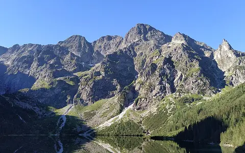
The Western Carpathians rise east of the Vienna Basin and include the Beskids, Tatras, and lower parallel ranges of Czechia, Slovakia, and Poland. Gerlachovský štít stands in Slovakia's High Tatras. A 2019 presentation by the Geodesy, Cartography and Cadastre Authority of the Slovak Republic reported 2,654.787 m by GNSS, 2,654.75 m from a point cloud, and 2,654.784 m from 1964 spatial triangulation.[4] The agreement supports the atlas value of 2,654.8 m, but the summit slide does not state the vertical datum beside those results.
Eastward, the Eastern Carpathians run through southeastern Poland and western Ukraine before bending south through Romania. The Southern Carpathians then trend west between the Transylvanian Basin and the lower Danube lowlands toward the Iron Gate. Relief is discontinuous: high compact massifs alternate with long flysch ridges, limestone uplands, fault-bounded basins, and cross-range valleys. The Olt gorge through the Southern Carpathians is one example of a river corridor that interrupts a simple crest-line barrier.
The Apuseni Mountains lie inside the arc, west of the Transylvanian Basin. Some physical-geography classifications call them the Western Romanian Carpathians, but regional tectonic syntheses map the Apuseni as a distinct intra-Carpathian block rather than as part of the Western–Eastern–Southern main arc.[3] This page therefore treats them as a connected interior mountain group, not silently as a fourth sector of the arc.
Ocean closure, thrusting, basin opening, and volcanism
The Carpathians are the eastern part of the Alpine–Carpathian–Dinaridic orogenic system. Their present structure developed as fragments of continental crust—including the ALCAPA and Tisza–Dacia domains—moved relative to the European foreland while intervening oceanic and sedimentary basins closed. Cretaceous to Neogene convergence shortened the margins and stacked nappes: large sheets of rock displaced along low-angle thrust faults. Miocene retreat of the subducting slab was coupled to extension and subsidence inside the arc, helping open the Pannonian back-arc basin while thrusting continued along the outer Carpathian front.[3]
The outer arc is dominated by flysch, repeated beds of sandstone, mudstone, and related deep-water sediment deposited before deformation and later folded and thrust toward the foreland. These rocks commonly form elongated ridges and densely cut valleys rather than the sharpest summits. Inside the arc, older crystalline basement and Mesozoic sedimentary nappes build higher, more resistant massifs in the Tatras and Southern Carpathians; limestone and dolomite units support cliffs, gorges, and karst terrain.[3]
Volcanic rocks are concentrated mainly on the inner side, not spread uniformly across the range. A radiometric synthesis places Neogene–Quaternary magmatism in the Carpathian–Pannonian region between about 21 million and 30,000 years ago, with activity generally becoming younger eastward. The Vihorlat–Gutâi alignment and the Călimani–Gurghiu–Harghita chain record this inner-arc volcanism; the youngest dated part is the Ciomadul dome complex at the southeastern end.[5]
Folded flysch nappes
Deformed sandstone–mudstone sequences form long ridges along much of the northern and eastern mountain front.
Basement and carbonate rocks
Crystalline cores and limestone or dolomite nappes support rugged high relief, gorges, and karst.
Time-transgressive volcanism
Miocene to Late Pleistocene volcanic centres become broadly younger toward the southeast.
Patchy high-mountain ice, not an ice-covered arc
Pleistocene glaciers occupied the highest massifs, especially the Tatras and parts of the Rodna, Făgăraș, Parâng, and Retezat mountains. They excavated cirques, widened selected valleys into troughs, and left moraines and lake basins. Glaciation was discontinuous because most of the arc is too low to have supported connected ice fields; extensive forested and flysch sectors remained beyond the high-mountain glacier systems.[2][6]
The Retezat Mountains provide a dated Southern Carpathian example rather than a range-wide proxy. Cosmogenic 10Be measurements place their maximum ice extent at about 20.6+0.8−1.3 thousand years ago, followed by retreat phases ending near 14.4 ± 0.5 thousand years ago. The same study estimated only 1.1–1.8 m of cirque-floor erosion during the last glacial cycle, implying that repeated earlier glaciations helped create the inherited cirques seen today.[6] These local values should not be applied to the Tatras or the whole Carpathian arc.
Water routed inward and outward from the arc
Most inner slopes drain toward the Danube. The Tisza collects water from the Ukrainian, Slovak, Hungarian, and Romanian sides through the Bodrog, Slaná/Sajó, Someș/Szamos, Criș/Körös, and Mureș/Maros systems. The International Commission for the Protection of the Danube River defines the full Tisza basin as 157,186 km², the Danube's largest sub-basin; that measurement includes the Great Hungarian Plain and other lowlands, not just mountain catchments.[7] The Váh and Hron drain Western Carpathian sectors directly toward the Danube, while the Olt and Jiu cross the Southern Carpathians toward the lower river.
The northern divide sends the Poprad and Dunajec, and farther east the San, toward the Vistula and Baltic Sea.[8] In Ukraine, the Dniester rises on the outer side and flows independently to the Black Sea; the transboundary Dniester Commission identifies a 296 km Upper Carpathian reach before the river enters its middle Podolian section.[9] On the southeastern outer slopes, the Siret and Prut instead reach the Black Sea through the Danube.
Rain, seasonal snow storage, thaw, and steep tributary gradients produce mixed runoff regimes. Floods are not confined to a single melt season: the UNECE assessment of the Tisza basin records severe floods generated by rainstorms, snow, or rain–snow combinations at any time of year.[10] Flysch catchments can also deliver abundant fine sediment and slope debris, while lakes and reservoirs in the receiving lowlands interrupt some downstream transfer.
Elevation, exposure, and shelter vary around the bend
The 1,450 km arc crosses strong west–east and vertical climate gradients, so no single station or annual rainfall value represents it. The CARPATCLIM project assembled quality-controlled, homogenized daily observations for the larger Carpathian region and interpolated them to a 0.1° grid for 1961–2010. Its mapped temperature and precipitation fields are a historical climatology, not a current 30-year normal and not measurements limited to the mountain polygon.[11][12]
Elevation lowers temperature and lengthens snow persistence in the Tatras and the highest Romanian massifs. Windward slopes receive enhanced precipitation when moist air is forced upward; descending air and enclosure shelter some intra-arc valleys and the Transylvanian and Pannonian basin margins. Aspect changes solar receipt and snowmelt timing, while the increasing continental influence toward the east strengthens seasonal temperature contrasts. These controls explain why high alpine terrain, wet forested ridges, and comparatively dry interior basins occur within the same named range.
Between the Alps, forelands, and Dinarides
At the northwest end, the Vienna Basin separates exposed Carpathian relief from the Alps even though both belong to the wider Alpine orogenic system. Outside the northern and eastern arc, a foredeep filled with sediment lies between the thrust front and the European platform. Inside, the Pannonian Basin occupies the back-arc domain and the Transylvanian Basin lies between the Eastern and Southern Carpathians and the Apuseni block.[3]
Near the Iron Gate, Carpathian structures approach the Balkan and Dinaridic systems, but those neighboring belts have distinct tectonic units and should not be treated as one continuous named range. Use the mountain hub to compare their relief, or follow the arc's inward drainage through the Danube River record.
Sources and measurement notes
- UNEP and European Academy of Bolzano (EURAC Research), Implementing an International Mountain Convention: An Approach for the Delimitation of the Carpathian Convention Area (2006), pp. 15–16. Source for the Bratislava–Iron Gate frame, approximate 1,450 km length, 50–150 km width, 210,000 km² ecoregion, seven-country convention context, and the warning that the proposed Convention perimeter is a constructed regional boundary rather than a surveyed mountain edge.
- Mráz, P., and Ronikier, M., “Biogeography of the Carpathians: evolutionary and spatial facets of biodiversity,” Biological Journal of the Linnean Society 119(3), 528–559 (2016). Source for the broader 1,300–1,500 km by 100–350 km mountain concept, marginal-country and Serbian-scope differences, physical isolation and heterogeneity, and the limited, discontinuous effect of Quaternary glaciation.
- Schmid, S. M. et al., “The Alpine–Carpathian–Dinaridic orogenic system: correlation and evolution of tectonic units,” Swiss Journal of Geosciences 101, 139–183 (2008). Regional tectonic map and synthesis used for the arc's relation to the European foreland, Pannonian and Transylvanian basins, ALCAPA and Tisza–Dacia units, nappes, flysch belts, crystalline–Mesozoic units, and the distinct intra-Carpathian position of the Apuseni Mountains.
- Tatra National Park Administration, Basic information (accessed 30 August 2026), identifying Gerlachovský štít as the highest summit of the Carpathian arc; and Leitmannová, K. et al., Geodesy, Cartography and Cadastre Authority of the Slovak Republic, Stav projektu leteckého laserového skenovania SR (2017–2023), presentation to the 27th Slovak Geodetic Days (7–8 November 2019), slide 22. Source for the 2,654.787 m GNSS, 2,654.75 m point-cloud, and 2,654.784 m 1964 triangulation results. The slide does not label the summit value's vertical datum; the page therefore rounds the GNSS result to 2,654.8 m and does not imply centimetre accuracy.
- Pécskay, Z. et al., “Geochronology of Neogene magmatism in the Carpathian arc and intra-Carpathian area,” Geologica Carpathica 57(6), 511–530 (2006). Source for volcanic-belt locations, the 21 Ma to approximately 0.03 Ma dated range, west-to-east migration, and the separate intra-Carpathian Apuseni volcanic field.
- Ruszkiczay-Rüdiger, Z. et al., “Limited glacial erosion during the last glaciation in mid-latitude cirques (Retezat Mts, Southern Carpathians, Romania),” Geomorphology 384, 107719 (2021). Source for patchy Southern Carpathian glaciation, the Retezat maximum and retreat chronology, cirque and trough context, and the 1.1–1.8 m last-cycle erosion estimate.
- International Commission for the Protection of the Danube River, Tisza Basin (accessed 30 August 2026). Source for the 157,186 km² basin area, Danube sub-basin ranking, three-part Tisza division, and named Carpathian-fed tributaries. The basin area includes mountains and lowlands.
- United Nations Economic Commission for Europe, Second Assessment of Transboundary Rivers, Lakes and Groundwaters, Chapter 8: Drainage Basin of the Baltic Sea (2011), Vistula River Basin section. Source for the Vistula's Baltic outlet and the Poprad, Dunajec, and San transboundary tributary connections.
- Commission on Sustainable Use and Protection of the Dniester River Basin, Dniester River Basin: Region (accessed 30 August 2026). Source for adjoining Prut, Tisza, and San/Vistula divides and the definition and 296 km length of the Upper Carpathian Dniester reach.
- United Nations Economic Commission for Europe, Our Waters: Joining Hands Across Borders—First Assessment of Transboundary Rivers, Lakes and Groundwaters, Part 2 (2007), Tisza River section. Source for the Carpathian ridge's relationship to the Tisza basin and the rainstorm, snow, and rain-generated flood regime.
- Spinoni, J. et al., “Climate of the Carpathian Region in the period 1961–2010: climatologies and trends of 10 variables,” International Journal of Climatology 35(7), 1322–1341 (2015). Source for the quality-controlled, homogenized, harmonized observations, 0.1° gridding, 1961–2010 period, and the regional variability of temperature and precipitation.
- CARPATCLIM Consortium and European Commission Joint Research Centre, CARPATCLIM data access, version 1.0 (2013 release; accessed 30 August 2026). Direct dataset record for daily mean, minimum, and maximum temperature and precipitation on the 0.1° larger-Carpathian grid for 1961–2010; the dataset covers about 500,000 km² and is not a mountain-boundary dataset or a current climatological normal.