
A conventional geographic system
Atlas Mountains is the approved conventional English name; Atlas system, Atlas belt, and Atlas chain are common geological collective terms. The Arabic form recorded by the United Kingdom's Permanent Committee on Geographical Names is جبال الأطلس (Jibāl al Aţlas). Its 2025 factfile classifies the feature as a mountain range spanning Morocco, Algeria, and Tunisia and supplies 32°00′N, 2°00′W as a finding coordinate. That rounded WGS84 point helps locate the system; it is not a surveyed centroid or boundary.[1]
This page uses the broad physical-geography convention: the Moroccan High, Middle, and Anti-Atlas; the eastward Algerian Atlas ranges and High Plateaux; and the related Tunisian ranges. It does not include the Rif of northern Morocco. The Tell Atlas is included as part of the conventional geographic family, but tectonic studies distinguish the coastal Tell–Rif or Maghrebides—formed along the former Maghrebian Tethys—from the intracontinental Atlas developed farther south in older rift basins. The Anti-Atlas is also not merely a southern copy of the High Atlas: it is an older foreland uplift built around Proterozoic and Paleozoic rocks.[3][5]
From Atlantic Morocco to Tunisia
The system has no single surveyed outer edge. A geological definition places it between the Tell–Rif front in the north and the South Atlas Front beside the Saharan platform, running for more than 2,000 km from Morocco to Tunisia. Broader map conventions add the Tell ranges and Anti-Atlas, so a longer figure based on those outlines would describe a different object. No dependable natural-area or maximum-width figure is used here because range fronts merge into plateaux, basins, and foothills rather than enclosing a stable polygon.[2]
In Morocco, the High Atlas runs west-southwest to east-northeast for about 650 km; the Middle Atlas branches northeastward, while the Anti-Atlas extends roughly 400 km south of the Souss and Ouarzazate basins. These rounded component lengths come from a 2023 geological synthesis and must not be added to obtain the length of the whole system. Eastward, the Algerian Atlas includes the Saharan Atlas and Aurès fold-and-thrust belts; broad High Plateaux lie between them and the Tell. Relief becomes lower and more discontinuous through Tunisia toward the Mediterranean and Saharan lowlands.[3][4]
Highest and most branched
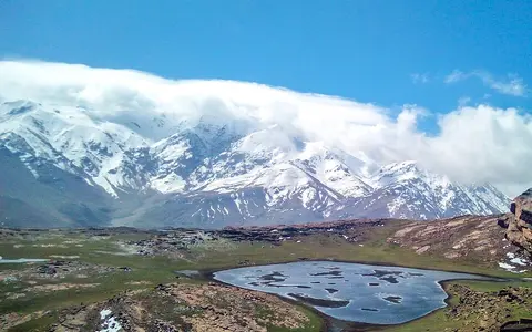
High and Middle Atlas ridges meet elevated basins and the older Anti-Atlas foreland.
Parallel belts and plateaux
The Tell, High Plateaux, Saharan Atlas, and Aurès form a broad north–south sequence.
Lower eastern continuation
Folded ridges descend toward steppe, saline depressions, and the Mediterranean margin.
Rift inversion plus deep support
During Late Triassic and Jurassic extension, faults opened continental basins across the region as the central Atlantic and Tethyan domains developed. Thick marine and continental sediments accumulated in those basins. Later Africa–Eurasia convergence reversed many normal faults: compression folded the sedimentary fill, drove thrusts toward the basin margins, and raised the High, Middle, Saharan, and Tunisian Atlas. Geologists call that process tectonic inversion—an old extensional basin is shortened and uplifted instead of a new fault system starting from scratch.[3]
Shortening alone does not account for all of the western elevation. Seismic, gravity, heat-flow, and topographic modelling identifies unusually thin, warm lithosphere beneath a northeast-trending zone crossing the Anti-Atlas, High Atlas, and Middle Atlas. Recent work interprets mantle upwelling, related volcanism, and inherited crustal faults as working together with compression. The balance varies along the belt: crustal shortening is more important in some High Atlas sectors, whereas buoyant hot mantle contributes substantially to the broad Moroccan uplift.[2][4]
The Anti-Atlas preserves a much longer record. Its inliers expose Paleoproterozoic and Neoproterozoic basement, including remnants of Pan-African oceanic and volcanic-arc rocks, beneath Paleozoic cover folded again during later orogenies. Cenozoic Atlas compression gently arched the whole domain, and modelling attributes about 1,000 m of additional crest elevation to the underlying hot-mantle anomaly. That estimate describes a long-wavelength uplift component, not the height of an individual ridge.[5]
Structural grain directs valleys
Rock type and fold geometry produce the Atlas's alternating ridges and basins. Resistant limestone and other carbonate beds commonly hold narrow crests and gorge walls; weaker marl and shale are eroded into broader valleys. In the central and eastern High Atlas, many long river reaches occupy synclines—downfolds in the layered rock—and run parallel to the mountain belt before turning through fold ends or faults. Granite and volcanic rocks form sharper massifs in the western High Atlas, including the Toubkal area, while the Anti-Atlas exposes broad domes and inliers of older basement through its younger cover.[5][7]
Relief therefore changes along strike as well as across it. Toubkal reaches 4,167 m above sea level in Morocco's Marrakech High Atlas, but the figure is best treated as a published map elevation: the reviewed sources agree on 4,167 m yet do not report the original survey method, epoch, or vertical datum. The surrounding range includes steep cirques and deeply incised valleys, whereas wide parts of the Middle Atlas, Algerian High Plateaux, and Anti-Atlas are elevated surfaces broken by scarps, folds, and river canyons rather than continuous alpine crests.[6][8]
Strong gradients, not one Atlas climate
Atlantic and Mediterranean winter weather reaches the northern and western slopes first. Forced ascent over the mountains cools moist air and increases rain or snowfall; descending air, distance from the sea, and Saharan influence make many interior and southern sectors much drier. Elevation lowers temperature, while slope aspect changes solar exposure and snow persistence. The result ranges from Mediterranean seasonal climates on exposed slopes to cold semi-arid plateaux and arid desert margins. A single precipitation value cannot represent this system.[6][8]
A 2022 review of the Moroccan Atlas—not Algeria or Tunisia—reports mean annual precipitation of about 150–250 mm on adjoining plains and more than 800 mm in the highest sectors. It cites site studies in which 20–80% of precipitation at high elevation fell as snow; that broad interval reflects location and elevation, not a range-wide mean. The same review used MODIS satellite products to show that the maximum snow-covered area over the Moroccan Atlas varied from 13,433 km² in 2013–2014 to 42,000 km² in 2004–2005. Those are seasonal image-derived maxima for specific years, not permanent snow extents.[6]
Three destinations for mountain water
On the High Atlas's northern flank, the Tensift and Oum Er-Rbia systems carry water west to the Atlantic, while the Moulouya drains northeast to the Mediterranean. South of the crest, the Souss and Draa trend toward the Atlantic and the Ziz ends in the Sahara. The Draa is not continuously through-flowing to the ocean: water can evaporate or infiltrate before reaching its lower course. These routes show why “Atlas watershed” is misleading—the mountains divide several independent catchments rather than forming one basin.[7]
Some channels first follow weak rocks along folds for tens of kilometres, then turn across the structural grain through gorges. Melt from seasonal snow can delay part of the winter water input into spring, recharge aquifers, and augment river flow, but its contribution varies sharply among years and catchments. Farther east, runoff also enters enclosed high-plateau and Saharan depressions. In Tunisia, for example, Chott El Jerid is a 586,187 ha Ramsar-listed saline depression between the Cherb range and the desert; that designated wetland area is not an area measurement for the Atlas itself.[6][9]
Former glaciers, modern snowpatches
There are no modern glaciers in the High Atlas. Cirques, moraines, and glacially modified valleys nevertheless record colder Pleistocene conditions. A review of dated landforms in the Marrakech High Atlas gives a mean age of 12.3 ± 0.9 thousand years for Younger Dryas cirque moraines and a reconstructed mean equilibrium-line altitude of 3,213 m. An equilibrium line is the altitude on a glacier where annual accumulation and loss balance; it is a modelled palaeoclimate indicator, not a former continuous snowline across the whole Atlas.[8]
Modern snow is seasonal and exceptionally variable. The same field and satellite review found at least four high, shaded sites where snow sometimes survives summer, all in north- or northeast-facing hollows above 3,100 m. It distinguishes true glacier moraines from pronival ramparts, ridges of debris built downslope of persistent snowpatches. That distinction matters: late-lying snow and probable high-elevation permafrost do not constitute living glaciers.[8]
Mountain fronts linked to plains and desert
North and west of the Moroccan ranges, the Saïs, Tadla, Haouz, and Souss lowlands receive mountain water and sediment. The Ouarzazate basin separates much of the High Atlas from the Anti-Atlas. In Algeria, the High Plateaux lie between coastal Tell relief and the Saharan Atlas; south-facing piedmonts descend to the Sahara. These are physical transitions that cross national and provincial borders, not boundaries created by them.[2][3][5]
Follow the Sahara record for the adjoining arid region, Ouzoud Falls for a High Atlas tributary and limestone escarpment, or the mountain hub to compare this composite system with other ranges.
Data sources and publications
- Permanent Committee on Geographical Names. Tunisia: Toponymic Factfile, edition 2 (September 2025), pp. 10–11; and National Geospatial-Intelligence Agency, Geographic Names Server (accessed 30 August 2026). Approved English and Arabic names, three-country scope, feature type, rounded finding coordinate, WGS84 basis, and approximate-coordinate qualification.
- Missenard, Y., and others. “Crustal versus asthenospheric origin of relief of the Atlas Mountains of Morocco,” Journal of Geophysical Research: Solid Earth 111 (2006). More-than-2,000 km geological extent, Atlas-system boundaries, inverted Moroccan rifts, Anti-Atlas setting, and lithospheric support for relief.
- Bracène, R., and Frizon de Lamotte, D. “Post-Cretaceous kinematics of the Atlas and Tell systems in central Algeria: Early foreland folding and subduction-related deformation,” Comptes Rendus Geoscience 338 (2006), 115–125. Geological distinction between Tell–Rif and Atlas systems, Mesozoic rifting, Cenozoic inversion, Algerian High Plateaux, Saharan Atlas, and Aurès.
- Lanari, R., and others. “The Atlas of Morocco: A Plume-Assisted Orogeny,” Geochemistry, Geophysics, Geosystems 24 (2023), e2022GC010843. High Atlas and Anti-Atlas component lengths, structural variation, shortening, uplift, mantle anomaly, and volcanism.
- Michard, A., and others. “The Anti-Atlas Pan-African Belt (Morocco): Overview and pending questions,” Comptes Rendus Geoscience 350 (2018), 279–288. Anti-Atlas hierarchy, Proterozoic and Paleozoic structure, adjoining basins, Cenozoic folding, and estimated mantle-supported uplift.
- Hanich, L., and others. “Snow hydrology in the Moroccan Atlas Mountains,” Journal of Hydrology: Regional Studies 42 (2022), 101101. Regional precipitation contrast, high-elevation snow fraction, measurement network, seven Moroccan catchments, and MODIS snow-cover variability for 2000–2016.
- Babault, J., van den Driessche, J., and Teixell, A. “Longitudinal to transverse drainage network evolution in the High Atlas (Morocco): The role of tectonics,” Tectonics 31 (2012), TC4020. Named High Atlas drainage routes and relationships among rivers, folds, faults, and erodible rock units.
- Hughes, P. D., and others. “Late Pleistocene glaciers to present-day snowpatches: a review and research recommendations for the Marrakech High Atlas,” Mediterranean Geoscience Reviews 2 (2020), 163–184. Absence of modern glaciers, dated Younger Dryas moraines, reconstructed equilibrium-line altitude, present snowpatches, and periglacial interpretation.
- Ramsar Sites Information Service. Chott El Jerid, site 1699 (designation information dated 7 November 2007; accessed 30 August 2026). Designated area, coordinates, saline-depression setting, and relationship to the Cherb range and northern Sahara.