
One region with graded edges
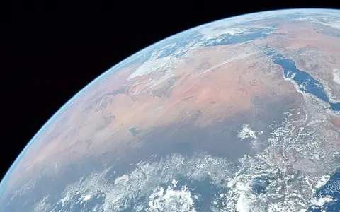
“Sahara Desert,” usually shortened to “the Sahara,” names the transcontinental arid region rather than an administrative unit. From west to east it crosses Western Sahara and parts of Morocco, Mauritania, Mali, Algeria, Niger, Tunisia, Libya, Chad, Sudan, and Egypt. Political borders partition the region but do not define its physical limits. The Atlantic is the western margin and the Red Sea the eastern one; the Atlas Mountains and Mediterranean drylands frame much of the north, while the semi-arid Sahel forms a broad southern transition.[2]
The Libyan Desert, Nubian Desert, and Ténéré are named subregions with their own physical scope; none is an alternative name for the whole Sahara. Nor is the Sahel simply the desert's southern half: it is a rainfall and vegetation transition whose position varies by season and from year to year.
Area figures therefore depend on the rule used to draw a line. NASA's broad overview gives about 9.2 million km².[1] Nigam and Thomas instead mapped grid cells receiving less than 100 mm of mean annual precipitation and obtained a 1920–2016 climatological extent of 7.518 million km²; raising the threshold to 150 mm enlarges the polygon. Their analysis also found seasonal and multidecadal movement of the edges.[3] These are different measurement frames, not rival measurements of a fixed object.
Rock country interrupted by sand and mountains
Ergs are extensive sand seas, but a peer-reviewed Saharan overview estimates that they occupy about 20% of the region.[2] Much of the remaining ground is exposed rock, sediment, or desert pavement. A reg or serir is a stony or gravel surface from which finer material has been removed; a hamada is a hard, rocky plateau. Alluvial fans spread from uplands, while playas and sebkhas occupy closed lows where episodic water and evaporation leave silt, clay, or salts. The terms describe surface form, not separate climatic zones.
The low plains and plateaus are broken by the Ahaggar and Aïr uplands in the central-western Sahara, the sandstone plateaus of Tassili n'Ajjer and Ennedi, and the volcanic Tibesti in the central-east. UNESCO describes Tassili n'Ajjer as a 72,000 km² plateau containing Precambrian crystalline rocks and sedimentary sandstone successions sculpted by water and wind.[6] At the southeast end of Tibesti, Emi Koussi is an intraplate pyroclastic shield volcano built over Cretaceous and Palaeozoic sandstone. The Smithsonian Global Volcanism Program gives its summit as 3,415 m at 19.8°N, 18.53°E and maps nested summit calderas about 12 by 15 km across.[4]
At the other relief extreme, the internally drained Qattara Depression cuts into Tertiary sedimentary rocks in Egypt's Western Desert. Geological field work measured its floor as much as 134 m below sea level and interpreted the basin as a former stream valley modified by karst dissolution, wind deflation, mass movement, and intermittent flowing water.[5] Emi Koussi and Qattara show why a single “flat sand desert” description fails.
Ergs and sand sheets
Wind sorts and transports sand into dune fields; their crests and margins can migrate without moving the climatic desert boundary.
Regs and serirs
Wind removes finer particles and leaves gravel or stones as desert pavement.
Hamadas and massifs
Rock plateaus, faulted uplands, eroded sandstone, and volcanic centres create major local elevation and runoff contrasts.
No single event formed the Sahara
The Sahara is a climate-defined region laid across several geological provinces. Precambrian shield and mobile-belt rocks crop out in southern and central massifs, but Palaeozoic through Cenozoic sedimentary rocks cover much of the wider region.[2] Later uplift, faulting, intraplate volcanism, river incision, groundwater dissolution, lake deposition, and wind erosion acted on that varied foundation. “Formation of the Sahara” therefore cannot be assigned to one rock unit or one date.
Present surfaces also inherit repeated humid–arid cycles. Radar beneath the very dry Selima Sand Sheet in the eastern Sahara revealed sand- and alluvium-filled valleys, some nearly as wide as the Nile Valley. The USGS investigators attributed the large buried valleys to vanished river systems and smaller incised wadis to intermittent runoff during Quaternary wet intervals.[7] Wind now reworks sediment that rivers and lakes produced or rearranged under wetter climates.
Through-flow, internal lows, and ancient recharge
Most Saharan channels are wadis that flow only after rain, and many catchments are endorheic: water moves toward an internal low rather than the sea. Other extremely dry sectors are arreic, meaning that no integrated surface-drainage network functions today. The Nile River is the major through-flow across the eastern Sahara; its connected trunk contrasts with short-lived local runoff, closed salt basins, and the buried palaeovalleys around it.
Groundwater is not one Sahara-wide underground lake. It occupies separate porous or fractured rock systems. The Nubian Sandstone Aquifer System beneath Chad, Egypt, Libya, and Sudan covers about 2 million km². An IAEA–UNESCO–UNDP project brief describes its water as ancient and effectively non-renewable at the management timescale and uses “fossil” in that specific hydrogeological sense.[8] The area is the aquifer-system footprint, not the area of the Sahara.
The Lakes of Ounianga in northeastern Chad show how groundwater can maintain surface water even within a hyperarid basin. UNESCO records less than 2 mm of rain a year there, yet groundwater sustains 18 fresh to hypersaline lakes in two groups 40 km apart. Lake Yoan is 27 m deep and 358 ha in area; Lake Teli is larger in surface area at 436 ha but less than 10 m deep.[9] Those measurements belong to individual lakes, not to the wider Ennedi region.
Why rain is scarce—and why its season changes
Subtropical aridity is reinforced by sinking air and stable layers that suppress the deep ascent needed for widespread rain. The mechanism is more seasonal than a simple permanent high-pressure label suggests. In summer, compensating descent associated with the Asian monsoon and circulation around the African easterly jet help inhibit rainfall over the Sahara; cold Canary Current upwelling and marine stratus add surface cooling and stability along the Atlantic margin.[10]
Storm sources differ across the desert. The northern Sahara receives most of its limited precipitation in the cooler season from Mediterranean cyclones, fronts, and upper-level troughs. The southern margin receives most rain in summer, when the tropical rain belt moves north and African easterly waves, cloud clusters, or squall lines reach the desert edge. Transition-season interactions occasionally carry moisture far into the interior.[10] Mountain slopes can enhance local rain and runoff, so “less than 100 mm/year” is useful as a mapping threshold but not a value that applies to every summit, coast, or margin.
The Green Sahara was a climate phase, not another place
During the early Holocene African Humid Period—about 11,000 to 5,000 years before present—greater rainfall supported grasslands, permanent lakes, and extensive drainage across areas that are desert today. Marine leaf-wax isotope records indicate that wet conditions in the western Sahara reached about 31°N and that vegetation and reduced-dust feedbacks helped amplify the rainfall response.[11]
Changes in Earth's orbital precession altered Northern Hemisphere summer sunlight and strengthened the northward reach of monsoonal rain; land-cover and dust feedbacks magnified the response. The timing and rainfall total were not uniform everywhere, and northern winter-rain influence also matters in some reconstructions. The evidence supports repeated rearrangement of lakes, rivers, vegetation, and sediment—not the idea that all modern dunes appeared suddenly when one uniform “Green Sahara” ended.
Deflation links old lake beds to distant regions
Wind moves sand mainly by near-surface hopping and creep, but finer silt and clay can remain suspended and travel far beyond the desert. Depressions with loose sediment are especially effective dust sources. In the Bodélé Depression of Chad, field and satellite work located the core source near 17°N, 18°E on exposed diatomite—silica-rich sediment made from microscopic algae—deposited beneath former Lake Mega-Chad. Northeasterly flow accelerates between the Tibesti and Ennedi massifs, helping lift the material.[12]
CALIPSO lidar observations for 2007–2013 estimated that 182 teragrams of dust per year crossed 15°W from North Africa toward the Atlantic, with a stated overall known uncertainty of ±45–70%; 132 teragrams per year remained at 35°W.[13] A teragram equals one million metric tonnes. These are a seven-year mean, a latitude-integrated transport estimate, and a measurement of airborne dust—not a timeless erosion rate for the Sahara.
Read the Sahara by connected systems
The Atlas Mountains record explains a major northwestern relief and climate boundary, while the Nile River record follows the integrated river crossing the eastern desert. The Libyan Desert, Nubian Desert, and Ténéré pages narrow the scale to specific Saharan subregions. Return to the Desert Hub for category-wide navigation.
Sources and measurement notes
- NASA Goddard Space Flight Center, Global Modeling and Assimilation Office, “GMAO – African Dust” (released 16 November 2024; updated 3 January 2025). Source for the broad 9.2-million-km² arid-land estimate; it does not define a formal boundary polygon.
- Aboulahris, M. et al., “Characteristics of the Sahara as a meteorite recovery surface”, Meteoritics & Planetary Science 54, 2908–2928 (2019). Source for the approximate 16–32°N, 17°W–38°E frame, continental geological overview, regional margins, and the estimate that ergs cover about 20% of the Sahara.
- Nigam, S. & Thomas, N. P., “The Sahara Desert Hydroclimate and Expanse: Natural Variability and Climate Change”, in Encyclopedia of the World's Biomes (Elsevier, 2019). The cited 7.518-million-km² climatology uses a 100 mm/year threshold over 1920–2016; the chapter separately tests 150 mm/year and seasonal definitions.
- Smithsonian Institution, Global Volcanism Program, “Emi Koussi” volcano profile (accessed 29 August 2026). Database source for 19.8°N, 18.53°E, 3,415 m elevation, shield-volcano classification, rock types, and mapped caldera dimensions; no vertical datum is stated on the profile.
- Albritton, C. C. Jr., Brooks, J. E., Issawi, B. & Swedan, A., “Origin of the Qattara Depression, Egypt”, Geological Society of America Bulletin 102, 952–960 (1990). Source for the measured depth to 134 m below sea level and the depression's sedimentary, karstic, fluvial, and aeolian development.
- UNESCO World Heritage Centre, “Tassili n'Ajjer” (accessed 29 August 2026). Source for the 72,000 km² plateau description, Precambrian and sandstone geology, and water-and-wind erosion context; that area describes the listed property, not the Sahara.
- McCauley, J. F. et al., “Subsurface valleys and geoarchaeology of the eastern Sahara revealed by shuttle radar”, Science 218, 1004–1020 (1982), catalogued by the U.S. Geological Survey. Source for buried valleys beneath the Selima Sand Sheet and their interpretation.
- International Atomic Energy Agency, UNESCO, UNDP and Global Environment Facility, “The Nubian Sandstone Aquifer System Project: Mapping the World's Largest Known Fossil Aquifer” (project brief, 2013). Source for the four-country extent, approximately 2 million km² footprint, and ancient, non-renewable groundwater description.
- UNESCO World Heritage Centre, “Lakes of Ounianga” (accessed 29 August 2026). Source for rainfall, groundwater supply, lake-group spacing, and the reported lake areas and depths.
- Rieder, J. C., Aemisegger, F., Dente, E. & Armon, M., “Meteorological ingredients of heavy precipitation and subsequent lake-filling episodes in the northwestern Sahara”, Hydrology and Earth System Sciences 29, 1395–1427 (2025). Source for seasonal storm tracks and the atmospheric and oceanic controls that suppress or deliver Saharan rain.
- Tierney, J. E., Pausata, F. S. R. & deMenocal, P. B., “Rainfall regimes of the Green Sahara”, Science Advances 3, e1601503 (2017). Source for the approximately 11,000–5,000-year-before-present interval, western Saharan leaf-wax reconstruction, 31°N reach, and vegetation–dust feedback interpretation.
- Washington, R. et al., “Dust and the low-level circulation over the Bodélé Depression, Chad: Observations from BoDEx 2005”, Journal of Geophysical Research: Atmospheres 111, D03201 (2006). Source for the diatomite dust source near 17°N, 18°E and the topographically accelerated low-level flow.
- Yu, H. et al., “Quantification of trans-Atlantic dust transport from seven-year (2007–2013) record of CALIPSO lidar measurements”, Remote Sensing of Environment 159, 232–249 (2015). Source for the 182 and 132 Tg/year flux estimates, study period, integration frame, and ±45–70% known uncertainty.