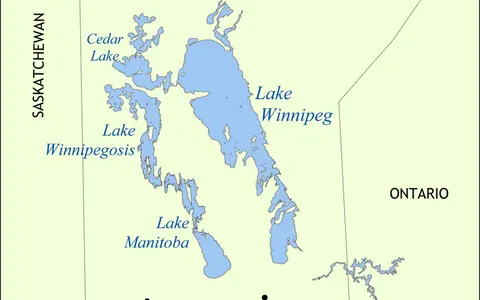

The lake, not its watershed
This record covers the standing water body from the low southern shore and south basin, through the islanded Narrows, to the north basin and the outlet at Warren Landing. It does not treat the nearly 1,000,000 km² drainage basin, former glacial Lake Agassiz, Playgreen Lake, or the Nelson River as parts of Lake Winnipeg itself. The catchment extends far beyond Manitoba into Alberta, Saskatchewan, northwestern Ontario, Montana, North Dakota, South Dakota, and Minnesota; the lake lies entirely within Manitoba.[1][8]
The Canadian Geographical Names Database represents the feature as a polygon and supplies a map-reference point at 52°07′55″ N, 97°15′40″ W (52.131944, −97.261111), relevant at 1:5,000,000 scale. That point is useful for locating the lake; it is not identified as a surveyed centroid, deepest point, shoreline boundary marker, or water-level gauge. The database also warns that polygon boundaries can differ from the base map because of source scale and datum.[1]
Broad basins joined by constrictions
Government sources report an approximate surface area of 23,750 km², a north–south length of 436 km, a maximum breadth of about 111 km, and an estimated volume of 284 km³. The area, breadth, and 1,750 km shoreline length are generalized morphometric figures: shoreline length depends on mapping scale, and area changes slightly with water level. They should not be read as cadastral boundaries or current observations.[2][3]
A larger north basin and a smaller, warmer south basin are connected by the Narrows around Long Point, Black Island, and neighboring islands. Mean depth is about 13.3 m in the north basin and 9 m in the south, compared with about 12 m for the lake as a whole. The broad basins are mostly much shallower than the narrow passages, where currents cross irregular bedrock and sediment relief. [2][4][8]
Smaller · mean depth ≈9 m
The Red and Winnipeg rivers enter this low, wind-mixed part of the lake.
Islands and deep passages
Constrictions focus throughflow and contain the lake's deepest reported soundings.
Larger · mean depth 13.3 m
Greater depth and higher latitude keep it cooler than the south basin in summer.
The maximum depth is not a settled number
Manitoba's current lake profile gives a maximum depth of about 36 m northeast of Black Island. The federal–provincial 2011 assessment instead describes nearly 60 m north of Black Island, and the 1994 and 1996 offshore geological surveys report passages in the Narrows and east of Black Island exceeding 60 m. Those surveys also distinguish the basin floors—no more than about 13 m in the south and 19 m in the north—from exceptional constricted channels.[2][4][8]
The cited summaries do not provide a shared vertical datum, sounding grid, or feature boundary that explains the 36 m versus roughly 60 m difference. This page therefore retains both published results, identifies what and where they describe, and does not promote either value as an exact universal maximum. Mean depths are more suitable for describing the scale of the two main basins.
A buried boundary beneath the lake
Lake Winnipeg crosses the boundary between low-relief Paleozoic carbonate rocks of the Interior Plains and higher-relief Precambrian crystalline rocks of the Canadian Shield. Seismic profiles collected in 1994 and 1996 showed that this boundary is not a simple copy of the modern shoreline: in the south, much of the Paleozoic sequence ends at a buried escarpment near the middle of the lake, while a Paleozoic outlier occurs near the eastern shore.[4][5]
Fine-grained sediment deposited in glacial Lake Agassiz drapes much of that older surface and locally exceeds 50 m thickness in the south basin and 100 m in the north. Major buried ridges include the George Island and Pearson Reef moraines—accumulations left at former ice margins. Sediment deposited by modern Lake Winnipeg is generally much thinner, rarely exceeding about 10 m in the offshore survey, and strong currents have eroded or rearranged sediment in the Narrows.[4][5]
Lake Agassiz receded; the modern lake kept changing
The modern water body occupies a low part of the much larger Lake Agassiz basin, but it is not simply an unchanged remnant shoreline. Geological cores indicate that much of today's south basin was dry land about 4,000 radiocarbon years ago. Later wetter climate, changes in the routes of the Saskatchewan and Assiniboine rivers, and progressive joining of smaller sub-basins helped produce the present connected lake.[4]
The land is still responding to removal of the former ice sheet. Postglacial rebound is faster toward the north, tilting the basin and producing a long-term southward transgression—movement of water over formerly dry land. Manitoba Geological Survey mapping identifies the drowned Netley Marsh shore as a clear modern expression: the lake's northward outlet remains higher relative to its southern margin, while waves continue to rework the low sediment shore.[4][6]
Four major tributaries, one northward system
The Red River enters the south end after flowing north across the former Lake Agassiz plain; its Assiniboine tributary extends drainage west across the prairies. The Winnipeg River enters the southeast from Shield lake country, the Saskatchewan River reaches the northwestern shore after passing through Cedar Lake and Grand Rapids, and the Dauphin River brings water east from Lake Manitoba and Lake St. Martin. Smaller eastern tributaries include the Berens, Bloodvein, Pigeon, and Poplar rivers. [2][8]
In the 2008–2016 state-of-the-lake reporting period, the Winnipeg River alone supplied 43% of gauged inflow. Whole-lake hydraulic residence time—a volume-and-flow estimate, not the travel time of every water parcel—averaged 3.1 years in that period. The same assessment found values from 2.5 to almost eight years across the preceding half-century, demonstrating that a timeless “three-to-five-year” label hides substantial wet–dry variability.[3]
Water moves generally north through the Narrows. At Warren Landing the natural outlet connects Lake Winnipeg to Playgreen Lake; the upper Nelson system then crosses a chain of lakes and divided channels before continuing northeast to Hudson Bay. The excavated Two-Mile Channel is a second Lake Winnipeg outlet rather than a second independent river.[7]
Managed outflow, variable water surface
Lake Winnipeg Regulation entered operation in 1976. The Two-Mile, Eight-Mile, Ominawin Bypass, and Kisipachewuk channel works increased outlet capacity by about 50%; the Jenpeg control structure, roughly 80 km downstream of the lake, regulates the west-channel route. The natural outlet to Playgreen Lake and the east channel of the Nelson remain distinct parts of the system. Regulation shifts outflow timing for downstream power generation and can reduce extreme shoreline levels, but it does not hold the lake at a fixed elevation.[7]
For 2008–2016, the reported mean wind-eliminated lake level was 217.77 m above sea level. “Wind-eliminated” means an average derived from several gauges to remove short-lived tilting of the water surface; it is not a surveyed basin elevation or a current reading. During the earlier 1999–2007 period, strong wind setup was estimated to raise water locally by 0.6–1.2 m, especially in fall and early winter, illustrating why one shoreline gauge cannot represent the whole lake at a moment in time. [3][8]
Usually mixed, but not uniformly so
Lake Winnipeg is commonly described as cold and polymictic: during the open-water season, wind mixes the water column repeatedly instead of allowing one stable summer layering event. That definition fits the shallow south basin especially well. The deeper north basin can develop temporary thermal stratification—a warmer layer over colder deep water—and the 2020 assessment reported more such observations during its preceding decade, while cautioning that the cause had not been established. [3][8]
The lake freezes over in winter, then receives a concentrated pulse of snowmelt through its tributaries in spring. Higher latitude and greater water volume keep the north basin about 2–3°C cooler than the south basin in midsummer in the 1999–2007 assessment; breakup there occurred about two weeks later on average, although the two basins often froze within days of one another. During open water, wind mixing resuspends fine bottom sediment, particularly in shallow reaches, while evaporation and direct precipitation contribute to the water balance.[8]
The centre of a Hudson Bay drainage network
Lake Winnipeg links drainage from the Rocky Mountain headwaters of the Saskatchewan system, the prairie Red–Assiniboine basin, the Winnipeg River's Shield lakes, and the connected Manitoba–Dauphin route. The combined water leaves through the upper Nelson system for Hudson Bay. This continental reach belongs to the watershed; the physical lake remains the Manitoba water body bounded at its tributary mouths and northern outlets.
Compare other standing-water basins through the lakes hub, follow the connected drainage in the river systems hub, or use the terrain index for the wider Interior Plains, Canadian Shield, and glacial lowland setting.
Sources and measurement notes
- Geographical Names Board of Canada, Lac Winnipeg / Lake Winnipeg / Weenipagamiksaguygun combined polygon, with the Lake Winnipeg record, Canadian Geographical Names Database key GBEIS (decision date 30 November 2016; records modified 16 February 2021; accessed 29 August 2026). Sources for official forms, feature type, Manitoba location, map-reference coordinate, stated scale, and boundary caveat.
- Manitoba Environment and Climate Change, Lake Winnipeg, “About the Lake” and “Physical Characteristics” (accessed 29 August 2026). Source for approximate area, width, shoreline length, volume, lakewide and basin mean depths, the published 36 m maximum, basin form, watershed extent, tributaries, outflow, and complete winter ice cover.
- Environment and Climate Change Canada and Manitoba Agriculture and Resource Development, State of Lake Winnipeg, 2nd Edition—Highlights (2020), pp. 2–4 (PDF pp. 4–6; accessed 29 August 2026). Source for 23,750 km² area, 436 km length, north–south climate contrast, recent north-basin stratification observations, nearly 1,000,000 km² watershed, 2008–2016 Winnipeg River inflow share, residence-time series, mean wind-eliminated level, and changing inflow and outflow. The report's time-bounded values replace timeless generalizations.
- Thorleifson, H. et al., Status of the Lake Winnipeg Project (NTS 62I, 62P, 63A, 63B, 63G and 63H), Manitoba Energy and Mines, Geological Services, Report of Activities 1998, pp. 196–209 (accessed 29 August 2026). Joint federal–provincial offshore survey source for seismic and coring methods, buried bedrock boundary, Lake Agassiz and modern-lake sediment thickness, moraines, current erosion, constricted depths over 60 m, and postglacial basin evolution.
- Todd, B. J., Lewis, C. F. M., Nielsen, E., Thorleifson, L. H., Bezys, R. K., and Weber, W., Lake Winnipeg: Geological Setting and Sediment Seismostratigraphy, Journal of Paleolimnology 19 (1998), pp. 215–243, doi:10.1023/A:1007997024412 (accessed 29 August 2026). Peer-reviewed source for the Interior Plains–Shield boundary, Paleozoic and Precambrian lake-floor relief, buried escarpment, glacial and postglacial sequences, and current-built sand waves.
- Manitoba Geological Survey, Overview of Manitoba Geology and Shoreline Sand and Gravel (accessed 29 August 2026). Sources for Lake Agassiz clay, continuing isostatic rebound, southward expansion of north-draining lakes, and the drowned and retreating south shore at Netley Marsh.
- Manitoba Environment and Climate Change, Lake Winnipeg Regulation, and Manitoba Hydro, Lake Winnipeg Regulation (accessed 29 August 2026). Sources for the Warren Landing–Playgreen natural outlet, Two-Mile second outlet, channel network, Jenpeg control, west- and east-channel distinction, 1976 operation date, and approximately 50% increase in outflow capacity.
- Environment Canada and Manitoba Water Stewardship, State of Lake Winnipeg: 1999 to 2007 (June 2011), especially pp. 7, 27–29 and 36 (PDF pp. 17, 37–40 and 46–47; accessed 29 August 2026). Source for basin mean depths, nearly 60 m constricted depth, watershed jurisdictions, wind setup, cold-polymictic classification, north–south temperature and breakup differences, mixing observations, and the distinction between broad basin floors and deep passages.