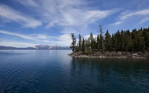

The lake, not the wider Tahoe region
“Lake Tahoe” is the current English name used in federal records; Lake Bigler is a former name found in the USGS geographic record. The Washoe name is commonly rendered Da ow a ga, meaning “edge of the lake.” This page covers the physical water body and its immediate basin setting—not the communities collectively called “Tahoe,” the surrounding Lake Tahoe Basin as an administrative region, or the much larger Truckee River watershed downstream.[1]
The lake's published dimensions are approximate. UC Davis reports about 191 mi² (495 km²) of surface, 22 mi (35 km) maximum length, 12 mi (19 km) maximum width, and roughly 75 mi (120 km) of shoreline, the last of which varies with water level. A peer-reviewed temperature study uses the same 495 km² area and a 501 m maximum depth; the mean depth is about 305 m (1,000 ft). Older USGS basin tables round the surface to 192 mi², a one-square-mile difference that should not be read as measured shoreline change.[3][4][5]
Between the Sierra crest and Carson Range
The elongated lake lies east of the main Sierra Nevada crest and west of the Carson Range. The state line crosses the water, placing most of the western shore in California and the eastern shore in Nevada, but it does not divide the hydrologic system. The drainage divide separates Tahoe runoff from west-flowing Sierra rivers on one side and from the Carson River basin on the southeast; only the northwest gap at Tahoe City carries surface water out.[5][9]
The surrounding land catchment is unusually small beside the lake. A USGS basin delineation gives 314 mi² (813 km²) of tributary land and 506 mi² (1,311 km²) for lake plus land. A current UC Davis overview rounds the land watershed to about 312 mi² (800 km²). The 2 mi² difference is consistent with different map delineations and rounding, not evidence of a changing drainage divide. Relief rises from the 6,223 ft natural rim to about 10,890 ft (3,319 m) on the basin divide—roughly 4,670 ft (1,420 m) of vertical range.[2][3][5]
A down-dropped block with a changing outlet
Lake Tahoe occupies a north-trending graben—a crustal block lowered between normal faults as the crust extended. The West Tahoe–Dollar Point fault zone follows the steep western side near the deepest water, while additional mapped faults cross or border the northern and eastern basin. Granitic rocks dominate much of the southern and western basin; younger volcanic rocks are concentrated in the north, and stream, lake, glacial, and landslide deposits mantle low ground.[7][9]
The basin did not form in one event with one precise “age.” Faulting established the depression over several million years, then erosion and eruptions repeatedly changed its outlet. Dated basaltic and trachyandesitic lava episodes dammed the Truckee River canyon about 2.3, 2.1, and 0.94 million years ago, raising Proto‑Tahoe to shorelines as much as nearly 200 m above the present level. Those lava dams later eroded, but by slowing canyon incision they helped preserve the soft-sediment outlet sill and the lake's great depth. The present outlet route has operated for at least 2.3 million years.[8]
Graben basin
Normal fault displacement created most of the accommodation space that now holds the lake.
Temporary lava dams
Eruptions raised ancient shorelines and slowed erosion of the northwest outlet canyon.
Shore and valley work
Ice cut western tributary troughs and deposited moraines; it did not excavate the main basin.
Fault scarps, a debris avalanche, and glacial bays
Multibeam mapping shows steep submerged margins on the north, east, and west and a gentler southern margin. Two broad plateaus in the northwest extend several kilometres offshore to about 40 m depth, while ridges on the west and north trace probable faults. This geometry makes “a simple deep bowl” an incomplete description of Tahoe.[6]
McKinney Bay on the west shore records a major slope failure about 300,000 years ago. Its debris avalanche crossed the basin and left blocks more than 1,000 m long and 80 m high on the floor; later, smaller slides and sediment flows continued to rework the margins. On the southwest shore, Emerald Bay occupies a glacier-cut Eagle Creek trough. Lateral moraines flank the bay and terminal deposits partly constrict its mouth. The approximately 160,000-year-old Tahoe glaciation reached the lake margin, and the less extensive Tioga glaciation, about 20,000 years ago, reworked western valleys and deposits.[6][10]
Snow-fed streams and one outward route
Sixty-three tributary streams enter Tahoe. The largest catchment belongs to the Upper Truckee River, which drains 56.5 mi² (146 km²)—about 18% of the mapped tributary land—and runs 21.4 mi (34.4 km) before entering the broad south-shore lowland. Trout Creek reaches the same lowland, while Ward and Blackwood creeks descend from the wetter western divide. Snowmelt usually supplies the principal spring and early-summer runoff pulse; rain-on-snow storms can instead produce short, erosive winter floods.[3][5][11]
The Truckee River leaves the northwest shore at Tahoe City, turns north and northeast through the Sierra, crosses Reno, and ends at Pyramid Lake in Nevada. Tahoe is therefore an open lake at the local scale but part of the endorheic, or internally drained, Truckee–Pyramid system at the regional scale: its water has no surface route to the ocean.[3]
Tahoe City Dam controls discharge only within the upper 6.1 ft (1.86 m) between the natural rim at 6,223.0 ft and the 6,229.1 ft legal maximum, both on the U.S. Bureau of Reclamation datum. The BOR zero differs from NGVD29 and NAVD88, so those numbers should retain their datum. During drought the lake may fall below the natural rim and surface outflow to the Truckee ceases; precipitation, tributary and groundwater inflow, evaporation, regulated release, and storage change then determine lake level.[2][5]
A snowy rain shadow above a deep heat store
Pacific frontal storms and the Sierra crest produce a strong west-to-east precipitation gradient. A basin technical assessment gives mean precipitation over the lake of about 35 in/yr (890 mm/yr) near the west shore and 20 in/yr (510 mm/yr) near the east shore; high western terrain reaches about 59 in/yr (1,500 mm/yr). The 1991–2020 NOAA normal at Tahoe City—a single northwest-shore station at 6,230 ft, not a basin mean—is 33.28 in (845 mm) of annual precipitation and 179.0 in (455 cm) of snowfall. Only 0.89 in (23 mm) of its precipitation falls in July through September, quantifying the dry-summer pattern.[11][12]
Tahoe is classed as a subalpine monomictic lake: it develops density layers as surface water warms, usually stratifies from late May to late December, and has one cold-season mixing period. It does not normally freeze. Winter cooling and wind mix the upper water to depths of hundreds of metres, but the entire 501 m column need not overturn each year; “monomictic” describes the annual circulation season, not guaranteed annual bottom renewal.[4]
Because mixing depends mainly on heat exchange at the lake surface, changes in air temperature alter the duration of stratification. Analysis of Tahoe temperature profiles since 1970 found stratification beginning 2.1 days earlier and ending 4.4 days later per decade over the observational period used in a 2021 study. Those are study-period trends, not fixed calendar dates for every year.[4]
From the Sierra Nevada to an interior terminal basin
Water falling immediately west of Tahoe's divide can cross California's Central Valley and reach the Pacific. Water falling inside the divide may be stored in the lake for centuries before following the Truckee to Pyramid Lake, where it ultimately leaves by evaporation. Tahoe therefore links snowy Sierra headwaters to an arid Great Basin terminal lake without itself being terminal.[3]
Compare its tectonic basin and seasonal circulation through the lake hub, follow its only outlet through the river hub, or place its fault scarps, moraines, deltas, and landslide deposits in the terrain index.
Sources and measurement notes
- U.S. Geological Survey, “Geologic Gazetteer of the Lake Tahoe Region”, Open-File Report 2002-370 (2002), for the former name Lake Bigler and the distinction between point-name records and mapped feature geometry; and U.S. Environmental Protection Agency, “About Lake Tahoe” (updated 16 June 2026; accessed 29 August 2026), for the Washoe name Da ow a ga.
- U.S. Geological Survey, monitoring location 10337000, Lake Tahoe at Tahoe City and monitoring location 390618120021101, Lake Tahoe Sample Point—Mid Lake (accessed 29 August 2026). Sources for the WGS84 reference point, 506 mi² drainage area, natural rim, legal maximum, and BOR–NGVD29–NAVD88 datum relationships.
- University of California, Davis, Tahoe Environmental Research Center, “Tahoe Facts and Trivia” (accessed 29 August 2026). Source for approximate area, length, width, shoreline, maximum and mean depth, land-watershed area, tributary count, outlet route, surface elevation, and basin high point.
- Woolway, R. I. et al., “Phenological shifts in lake stratification under climate change”, Nature Communications 12, 2318 (2021). Tahoe methods specify a 495 km², 501 m-deep subalpine monomictic lake and temperature-profile monitoring since 1970; the paper reports observed changes in stratification timing. Roberts, D. C. et al., “Snowmelt timing as a determinant of lake inflow mixing”, Water Resources Research 54 (2018), supports the mean depth, seasonal mixing pattern, lack of ice cover, and surface-heat control.
- U.S. Geological Survey, “Environmental Setting” and table 3, Streamflow and Water-Quality Data for Selected Watersheds in the Lake Tahoe Basin … through September 1998, Water-Resources Investigations Report 02-4030 (2002). Source for the 192 + 314 = 506 mi² basin accounting, 138 mi drainage perimeter, Upper Truckee dimensions, elevation range, dam control, and historic level variability.
- Gardner, J. V., Mayer, L. A. & Hughes Clarke, J. E., “Morphology and processes in Lake Tahoe (California–Nevada)”, Geological Society of America Bulletin 112 (2000), 736–746. Multibeam source for submerged slope geometry, northwestern plateaus, fault ridges, the approximately 300 ka McKinney Bay failure, debris dimensions, and Tahoe-glaciation deposits.
- U.S. Geological Survey, Quaternary Fault and Fold Database record 216, “West Tahoe–Dollar Point fault zone” (reviewed 6 December 2016; accessed 29 August 2026). Source for the normal-fault sense, graben interpretation, west-basin escarpment, and mapped relation to adjacent Tahoe faults.
- Kortemeier, W. T., Calvert, A. T., Moore, J. G. & Schweickert, R. A., “Pleistocene volcanism and shifting shorelines at Lake Tahoe, California”, Geosphere 14 (2018), 1185–1206, doi:10.1130/GES01551.1. Source for dated lava episodes, Proto‑Tahoe shoreline elevations, outlet-canyon history, and preservation of the lake sill.
- California Geological Survey, Geologic Map of the Lake Tahoe Basin, California and Nevada, Regional Geologic Map 4, version 1.0, scale 1:100,000 (2005), compiled with USGS and Nevada Bureau of Mines and Geology. Source for mapped faults, granitic and volcanic units, moraine crests, and unconsolidated deposits.
- California State Parks, “Emerald Bay State Park,” Geological Gems of California State Parks, GeoGem Note 34 (2015), pp. 76–77. Source for Eagle Creek glacier flow, lateral and terminal moraines, and approximate Tahoe- and Tioga-stage glacial chronology.
- California Regional Water Quality Control Board, Lahontan Region, and Nevada Division of Environmental Protection, Lake Tahoe Total Maximum Daily Load Technical Report (2010), sections 3.2–3.3. Source for runoff seasonality, rain-on-snow processes, and measured west-to-east and elevation-related precipitation contrasts.
- NOAA National Centers for Environmental Information, 1991–2020 Summary of Monthly Normals, Tahoe City, California, station USC00048758 (generated and accessed 29 August 2026). Point-station source for annual and monthly precipitation and snowfall; station elevation is 6,230 ft.