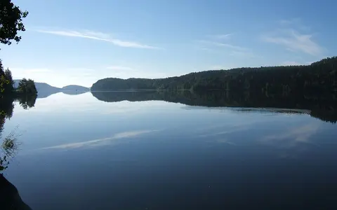

The lake, not the entire watershed
The accepted English name on this page is Lake Ladoga. The Russian local form is Ladozhskoye Ozero; Laatokka is an established Finnish name. Those names identify the same standing-water body. This record does not use “Ladoga” to mean the much larger transboundary drainage system, the Ladoga–Pasha structural depression, an administrative district, or the Ladoga Skerries protected area.[1]
Ladoga extends roughly NNW–SSE for a mapped maximum length of 219 km and maximum width of 125 km. Its shoreline lies in the Republic of Karelia to the north and northeast and in Leningrad Oblast to the south and west; the administrative boundary does not divide the physical basin. The Karelian Isthmus stands between Ladoga and the Gulf of Finland, while the Valaam Archipelago occupies the transition between the irregular northern deeps and the more open central lake.[3][4]
A reported surface elevation of 5.1 m above sea level is used as an approximate lake level, not a surveyed point elevation: the bathymetric study does not specify its vertical datum, and the older World Lake Database profile gives 4.8 m. Average annual water-level fluctuation is about 0.7 m, so dimensions tied to a shoreline necessarily vary with level and mapping method.[2][3]
Water area, islands, and older totals
The latest published digital bathymetric model used 8,962 bathymetric and shoreline points from official nautical charts, interpolated depths by kriging to a 0.5 km grid, and integrated volume over the resulting bottom surface. It gives 17,765.4 km² for water, 847.8 km³ for volume, and 230 m for maximum depth. The same table lists 456.6 km² of islands and a 48.3 m mean depth.[3]
The frequently quoted 18,135 km² is a conventional total including islands, not the modelled open-water contour. The source table does not reconcile that total arithmetically with its separately listed water and island areas, so this page does not add those entries together. It also reports a 48.3 m mean depth, while division of its 847.8 km³ volume by 17,765.4 km² gives 47.7 m; a 2024 synthesis gives 48.7 m. “About 48 m” is therefore more defensible than false decimal precision.[3][4]
The World Lake Database retains an older 908 km³ volume and 51 m mean depth. The 2020 model explains that planimetric calculations from broad depth bands overstate volume and reports that denser sampling and direct integration revised an earlier digital estimate from 837 to 848 km³. This page uses the latest modelled water area and volume together and keeps the older values only as a documented edition difference.[2][3]
17,765.4 km²
Mapped lake surface after islands are excluded.
456.6 km²
Land enclosed within the total lake footprint.
18,135 km²
The conventional total including islands; the source does not reconcile it with the two entries at left.
Crystalline deeps and a low southern shelf
The lake crosses a major geological junction. Crystalline rocks of the Fennoscandian Shield underlie much of northern Ladoga, while the Russian Plate lies to the south and east. An older, fault-influenced Ladoga–Pasha depression supplied the broad structural low; repeated Quaternary ice sheets then eroded, streamlined, and filled that inherited relief. Calling Ladoga simply “a glacial lake” is therefore incomplete: glaciation remodelled a basin whose large-scale position and asymmetry were already controlled by bedrock structure.[4]
Northern Ladoga has a dissected bottom, deep enclosed hollows, bedrock islands, narrow straits, and a skerry coast. North of Valaam, the 2024 geological synthesis identifies 16 depressions deeper than 140 m, commonly aligned with mapped or inferred faults and separated in places by sills only 40–50 m deep. By contrast, much of southern Ladoga is only 5–20 m deep and slopes northward from low shores and the Svir and Volkhov river-mouth bays and southwestern outlet margin.[3][4]
That relief governs modern sediment routing. Coarser sand, gravel, cobbles, and boulders dominate many shallow and exposed zones; fine clayey silts accumulate in deeper central and northern water. Broad southern shallows are more readily resuspended during storms, whereas steep northern slopes and basin floors trap material in separated depressions. About 90.5% of the lake area overlies bottom below sea level—a cryptodepression—because the 230 m basin is far deeper than the roughly 5 m surface elevation.[3][4]
Ice retreat, changing thresholds, and the Neva outlet
Deglaciation of the Ladoga basin occurred approximately 14,200–13,300 calibrated years before present. During retreat of the Scandinavian Ice Sheet, the basin formed a northeastern arm of the Baltic Ice Lake and received glacial meltwater and varved clay. Later Baltic water-level changes and uneven glacial-isostatic uplift—the slow rebound of crust after loss of the ice load—repeatedly altered the lake's shoreline, outlet threshold, and connection across the Karelian Isthmus.[4]
The best-supported recent reconstruction places the Ladoga transgression—a late-Holocene lake-level rise—between about 5,700 and 3,300 calibrated years before present. Differential uplift restricted the older northern outlet while the newly connected Vuoksa and wetter conditions added water. Around 3,300 calibrated years before present, erosion across the Mga–Tosna divide established the modern Neva outlet and lake level fell toward its present position.[4]
The timing is not exact. The 2024 review records older estimates spread across more than a millennium and an alternative view in which a weak Neva channel existed before the final breakthrough. This page therefore treats about 3,300 calibrated years before present as a supported reconstruction for the establishment of the modern outlet, not a precisely dated first appearance of any channel.[4]
Three lake-fed inflows and one Baltic outlet
The Svir enters eastern Ladoga from Lake Onega, the Vuoksa reaches the northwestern shore from the Saimaa system in Finland, and the Volkhov flows north from Lake Ilmen into the shallow south. A modern hydrological synthesis reports these systems as about 34%, 27%, and 23% of inflow respectively. Rivers and streams supply roughly 85% of the water budget and direct precipitation about 10%; those are long-term budget shares, not proportions expected in every season or year.[5]
Basin-area figures differ because authors draw the accounting boundary differently. The 2020 bathymetric paper lists 258,600 km² as the drainage area; the 2024 geological synthesis defines a 282,700 km² whole catchment including its water bodies. The latter divides the connected system among the Ladoga (17.1%), Onega–Svir (29.1%), Ilmen–Volkhov (29.1%), and Saimaa–Vuoksa (24.7%) sectors. The whole basin crosses Russia and Finland and is much larger than the lake mapped on this page.[3][4]
The Neva is the single surface outlet. It leaves Ladoga's southwestern corner near Shlisselburg and flows west through Saint Petersburg to the Neva Bay of the Gulf of Finland. Published long-term mean outflow is about 2,500 m³/s; this is a climatic average, not a current discharge reading. With a modelled volume of 847.8 km³, the corresponding whole-lake residence-time estimate is approximately 11 years, although individual water pathways are shorter or longer.[2][3]
Depth makes one lake warm and freeze unevenly
Ladoga lies between moderately continental and maritime climatic influences: Atlantic cyclones and Arctic air alternately control weather over the basin. It is dimictic, meaning that surface cooling and warming carry the water column through freshwater's maximum-density temperature near 4°C and allow major vertical mixing in spring and autumn. Shallow southern water responds sooner than the deep northern basins, so stratification develops at different times across the lake.[4][7]
During spring warming, a moving thermal bar forms where nearshore water that has warmed above 4°C meets colder offshore water. It begins around the shallow margins and advances toward the lake centre; the 2007 thermal analysis places completion of stratification from mid-May in some regions to early July in the deepest regions. The front temporarily limits exchange between rapidly warming coastal water and the colder interior.[7]
Ice is annual but complete freeze-over is not. In the 1913–2015 ice series, mean first-freezing and final-breakup dates were 26 November and 15 May, and the whole lake froze completely in about 83% of winters. These are multi-decadal averages derived from station records, ice charts, aircraft surveys, and satellite observations. The same study found the period from 1990 onward milder than preceding decades; it should not be represented by a fixed “February–May” calendar. Shallow coastal water and the southern offshore zone freeze before the heat-rich deep northwest, while wind can reopen or shift ice during winter.[6]
From shield relief to Baltic drainage
Lake Ladoga belongs in the lake hub as a freshwater basin whose form reflects both inherited structure and glacial reshaping. Its Svir, Vuoksa, Volkhov, and Neva connections place it in the river systems hub; its skerries, submerged fault-guided hollows, shallow shelves, and postglacial shorelines connect it to the terrain index. Those links provide regional context without expanding this record's scope beyond the lake and its immediate physical basin.
Sources and measurement notes
- Library of Congress, Library of Congress Subject Headings: L, 34th ed. (2012), entry “Ladoga Lake (Russia),” p. L-17. Source for the established English heading and the Russian-transliterated and Finnish variant names. The catalog heading is a name authority, not a source for physical measurements.
- International Lake Environment Committee, Lake Ladoga, World Lake Database record EUR-37 (accessed 29 August 2026). Source for geographic bounds, the single Neva outlet, water-level variability, and the legacy 18,135 km², 908 km³, and 51 m figures. The profile says its place names are not updated and traces most physical dimensions to a 1966 hydrological volume; the page therefore does not use those older volume and mean-depth values as current model outputs.
- Naumenko, M. A., “Lake Ladoga Digital Bathymetric Models: Development Approaches and Insight for Limnological Investigations”, Limnological Review 20(2), 65–80 (2020). Principal source for model method, 0.5 km grid, 17,765.4 km² water area, separately listed island and conventional-total areas, 847.8 km³ volume, reported mean and 230 m maximum depth, length, width, 5.1 m elevation, annual level range, outlet discharge, residence time, depth zones, and cryptodepression. The table's area entries do not add consistently and its reported mean depth does not exactly equal volume divided by water area; both issues are retained and explained rather than silently harmonized. The vertical datum is not identified, so the elevation is labelled approximate.
- Subetto, D. A. et al., “The Geology, Geomorphology, and History of Lake Ladoga: A Review”, Doklady Earth Sciences 519(S1), S91–S109 (2024). Source for geological provinces and inherited structure, northern depressions and sills, sediment distribution, deglaciation chronology, Baltic Ice Lake phase, glacial-isostatic tilting, whole-catchment definition and subdivision, late-Holocene transgression, and the approximately 3,300 cal yr BP Neva reconstruction. The review explicitly documents alternative outlet chronologies, which remain qualified in the text.
- Kostrova, S. S. et al., “Holocene hydrological variability of Lake Ladoga, northwest Russia, as inferred from diatom oxygen isotopes”, Boreas 48(2), 361–376 (2019). Source for the modern Svir, Vuoksa, and Volkhov inflow shares, river-and-stream and precipitation contributions to the water budget, catchment context, and long residence-time framing. Percentages are literature-based long-term shares rather than a single-year gauge balance.
- Karetnikov, S., Leppäranta, M., and Montonen, A., “A time series of over 100 years of ice seasons on Lake Ladoga”, Journal of Great Lakes Research 43(6), 979–988 (2017). Source for the 1913–2015 ice dataset, mean first-freezing and final-breakup dates, 0.83 complete-freeze frequency, spatial freeze sequence, weather controls, and the post-1990 milder period. Dates describe the whole observed ice season, not continuous full-lake cover.
- Naumenko, M. A., Karetnikov, S. G., and Guzivaty, V. V., “Thermal regime of Lake Ladoga as a typical dimictic lake”, Limnological Review 7(2), 63–70 (2007). Source for the definition and timing of twice-yearly mixing, spatially staggered stratification, and spring thermal-bar movement. Its older morphometric figures are superseded here by the 2020 digital bathymetric model.