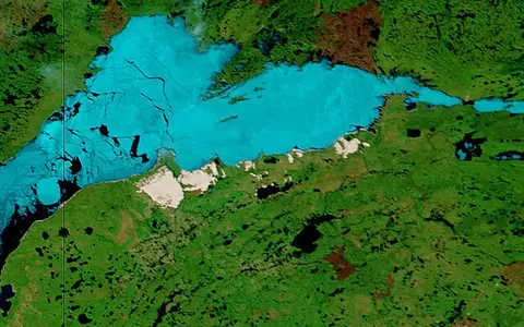

The lake, not the wider Athabasca Basin
The Geographical Names Board of Canada lists Lake Athabasca as the official English name in both provinces and Lac Athabasca as the official French form. Lake Athabaska is formerly official in Alberta. The database identifies the name's language of origin as nēhiyawēwin (Plains Cree). Its coordinate is a representative point attached to a polygon at 1:5,000,000 relevance, so it should not be read as a surveyed centroid.[1]
This page covers the connected lake surface and the physical processes immediately shaping it. The Athabasca River basin is one tributary catchment; the Athabasca sedimentary basin is a much larger geological region; and the Peace–Athabasca Delta includes channels, wetlands, Lake Claire, and Mamawi Lake beyond the open lake. None has the same boundary or area as Lake Athabasca. A federal study estimated that about 30% of the lake lies in Alberta, with the remainder in Saskatchewan.[4]
Delta shallows to eastern deep water
The Athabasca River reaches the southwest end through multiple distributaries beside Fort Chipewyan. The lake then extends eastward across the provincial boundary to Fond-du-Lac and the mouth of the Fond du Lac River. The outlet is also at the western end, so the largest inflow and the principal outflow are geographically close even though much of the lake stretches far to the east.[3][4]
The underwater shape is known unevenly. Canadian Hydrographic Service chart 6310 has spot soundings rather than a dense lake-wide bathymetric survey. A 2025 study summarizes the chart as less than 10 m deep in the western section, typically more than 50 m in the eastern basin, and 124 m at the deepest charted point. Its 2023 field transect found water less than 3 m deep within 20 km of the Athabasca Delta. These observations support a steep west–east contrast but not a precise whole-lake mean depth or volume.[3]
Why familiar figures do not all agree
Published surface areas depend on the shoreline representation and whether islands are included. A 2025 field study uses 7,850 km², while Environment and Climate Change Canada's legacy world-lake table gives a range of 7,935–8,080 km². Without a common dated shoreline and method, selecting one value to the nearest square kilometre would imply more certainty than the sources provide. This page therefore uses about 7,900 km² and does not combine the estimates.[2][3]
Lake level is variable rather than a permanent 213 m elevation. A 2005 reconstruction of the William River delta used a mean lake surface near 209 m and a fluctuation of approximately ±1.5 m over 1810–2000. Water Survey of Canada station 07MD001 at Fort Chipewyan has recorded lake level intermittently since 1930 and nearly continuously since the late 1960s. Values from a particular date still require the station datum and quality flag, so 209 m is retained only as historical orientation.[8][9]
Ice-modified relief across a rock boundary
The lake should not be reduced to a simple “Shield basin.” Low, poorly drained terrain, deltaic sediment, glacial till, and former lake deposits dominate the western margin. Precambrian Canadian Shield rock is exposed principally north of the lake, while quartz-rich Athabasca Group sandstone borders much of the southern Saskatchewan shore. That combination helps explain the change from low delta wetlands to rockier headlands, islands, sandy bays, and dunes.[4][7]
Laurentide ice reworked older relief and depressed the crust. During deglaciation, the Athabasca, Great Slave, and Great Bear basins formed parts of glacial Lake McConnell. The reconstructed lake existed from about 11.8 to 8.3 thousand years before present; as the land rebounded after loss of the ice load, drainage divides re-emerged and separated Lake Athabasca from Great Slave Lake. Those dates describe the changing proglacial-lake system, not the age of today's shoreline or a single episode of basin excavation.[6]
Alluvial lowland
River sediment, glacial deposits, wetlands, and shallow water form a low-gradient transition from delta to lake.
Exposed Shield terrain
Crystalline bedrock and thin cover contribute irregular bays, points, islands, and deeper adjacent water.
Sandstone and mobile sand
Athabasca sandstone, beaches, river deltas, waves, and wind supply and rework the dune fields.
Mountain runoff, Shield inflow, and a reversible outlet
The Athabasca River is the main surface-water source. It begins in the Rocky Mountains, drains a 159,000 km² subbasin, and brings water and sediment across Alberta to the southwest lake. Its mean flow for 2000–2023 was lowest in December–February at 165 ± 45 m³/s and highest in June–August at 1,141 ± 454 m³/s; these are seasonal means for the river, not total lake inflow. A historic water budget cited by the Northern River Basins Study attributed an estimated 52% of lake inflow to the Athabasca River and 21% to the Fond du Lac River, with the rest from other tributaries and local sources.[3][4]
The Fond du Lac River enters at the eastern end after draining lake-rich Shield terrain. The William and MacFarlane rivers enter the south shore, and many smaller streams drain the remaining local catchment. The 159,000 km² Athabasca River figure must therefore not be labeled as the total Lake Athabasca watershed.[3][7]
Water normally leaves toward the north-flowing Peace and Slave rivers through the Rivière des Rochers, Revillon Coupé, and Chenal des Quatre Fourches. The outlet network is controlled by relative water level, not by a permanent one-way gradient. When the Peace River rises above Lake Athabasca during a spring ice jam or summer flood, one or more connecting channels can slow, stop, or reverse toward the delta and lake. Downstream stage can therefore raise the lake even without a matching increase from its eastern tributaries.[5]
A river plume and a wave-fed dune coast
Coarse Athabasca River material settles rapidly near the delta; finer silt is resuspended and carried farther by currents and waves. Along a nearly 60 km transect sampled in July 2023, radiocarbon and sediment chemistry traced Athabasca River influence at least 50 km into the lake. Satellite imagery suggested that the affected area could exceed 1,500 km², but the study labels that area provisional pending more field and image analysis. This is a measured transport zone, not a permanent boundary between western and eastern water.[3]
On the south shore, the Saskatchewan dune complex extends between Ennuyeuse Creek and the MacFarlane River. Sand derived from Athabasca sandstone is delivered to beaches, moved upslope by waves and spring ice push, then transported inland by wind. Parabolic dunes are widespread, while oblique ridge dunes in active fields can stand as much as 35 m above their bases. Fire and shifting vegetation expose or stabilize local sand supplies, so migration is spatially uneven rather than a uniform advance of the entire dune coast.[7]
The William River demonstrates how lake energy reshapes a tributary mouth. A 2005 radar and geomorphic study mapped its south-shore delta as a 9 by 8 km, 15–22 m thick sand body, with beach ridges, offshore bars, and a submerged foreset slope. Long open-water fetch, strong winds, waves, and river sediment together make it a wave-dominated lake delta rather than a simple protruding river fan.[8]
Cold-season cover and open-water wind
Northern latitude and a continental interior setting produce long cold winters, short summers, seasonal lake ice, and a large annual temperature range. There is no long-term meteorological station on the south shore. The 2018 federal assessment therefore used Uranium City Airport, about 50 km north of the dunes, as a proxy: its cited monthly means were −23.3°C in January and 16.6°C in July, with 371 mm annual precipitation. The report warns that the exposed south shore can differ substantially, so these values are regional context rather than lake-wide normals.[7]
Winter ice suppresses direct wave action but stores snow and river ice for spring breakup. In the open-water season, wind acts across tens of kilometres of fetch, building waves, moving fine sediment, and temporarily tilting the water surface—known as wind setup. Runoff season is equally important: the Athabasca River's measured summer mean flow during 2000–2023 was about seven times its winter mean, while high downstream stage can obstruct the lake's outlet. The annual level cycle is therefore a combined response to inflow, outlet conditions, wind, precipitation, evaporation, and ice rather than temperature alone.[3][5][8]
Headwaters of the Mackenzie system
Lake Athabasca connects two distant source regions: the Athabasca River brings mountain and plains runoff from the southwest, while the Fond du Lac River brings Shield runoff from the east. Their water leaves through the western delta channels, joins the Slave River, crosses Great Slave Lake, and continues through the Mackenzie River to the Beaufort Sea. Lake Athabasca is thus an upstream storage basin in the Mackenzie network, not the source or main stem of the Mackenzie.
Use the lake hub to compare through-flow basins, the river systems hub to follow connected drainage, and the terrain index for the glacial, deltaic, sandstone, and Shield landforms that meet around the lake.
Sources and measurement notes
- Geographical Names Board of Canada, Lac Athabasca / Lake Athabasca combined feature record, and Lake Athabasca, Canadian Geographical Names Database key HAUGA (records modified 16 February 2021; accessed 29 August 2026). Sources for official English and French forms, former Lake Athabaska, nēhiyawēwin origin, feature type, and the 59.3669823° N, 108.0009763° W map reference. The coordinate belongs to a polygon with 1:5,000,000 relevance and is not presented as a surveyed centroid.
- Environment and Climate Change Canada, Water sources: lakes (page dated 10 September 2017; accessed 29 August 2026). Source for the legacy 7,935–8,080 km² area range and 60–124 m maximum-depth range. The page says its world-lake table was adapted from Peter H. Gleick's 1993 Water in Crisis; this article therefore uses the range to document published disagreement, not as a current shoreline survey.
- Chételat, J., Hebert, C., McClelland, C. and Greenwood, S., “Radiocarbon evidence of river transport and food web uptake of old carbon in Lake Athabasca, Canada,” Scientific Reports 15, article 31455 (26 August 2025; accessed 29 August 2026). Source for the 7,850 km² working area, 159,000 km² Athabasca River subbasin, 2000–2023 seasonal river discharge, chart 6310 bathymetric limitations and spot depths, 2023 western-lake depth observations, and measured sediment influence at least 50 km from the delta. The >1,500 km² influence zone is explicitly retained as a satellite-based estimate requiring more study.
- Bourbonniere, R. A., Telford, S. L. and Kemper, J. B., Depositional History of Sediments in Lake Athabasca: Geochronology, Bulk Parameters, Contaminants and Biogeochemical Markers, Northern River Basins Study Project Report 72 (January 1996; accessed 29 August 2026), especially section 2.1. Source for the approximate Alberta share, historic 52% Athabasca and 21% Fond du Lac inflow estimates, shallow western depositional setting, sparse older bathymetry, poorly drained lowland deposits, and the Canadian Shield outcrop pattern. The inflow percentages are historical estimates reproduced from a 1981 study, not a present-day annual water budget.
- Parks Canada, Hydrology—Wood Buffalo National Park (modified 2 February 2023; accessed 29 August 2026). Source for the Rivière des Rochers, Revillon Coupé, and Chenal des Quatre Fourches connections and for flow reversal when Peace River stage exceeds Lake Athabasca during spring ice-jam or summer flood events.
- Smith, D. G., “Glacial Lake McConnell: Paleogeography, age, duration, and associated river deltas, Mackenzie River basin, western Canada,” Quaternary Science Reviews 13(9–10), 829–843 (1994; accessed 29 August 2026). Source for the 11.8–8.3 thousand-year-before-present proglacial-lake interval, ice-load downwarping, and separation of the Great Slave and Athabasca basins by isostatic rebound. Those dates are not assigned to the modern shoreline.
- Committee on the Status of Endangered Wildlife in Canada, COSEWIC Assessment and Status Report on the Athabasca Endemics (2018; accessed 29 August 2026), pp. 75–77. Source for Athabasca sandstone as a sand source, the Ennuyeuse Creek–MacFarlane River limits, beach and ice-push supply, wind transport, dune forms and 35 m ridge height, fire effects, and Uranium City climate context. The report explicitly cautions that the off-site station may not represent the exposed south shore.
- Smith, D. G., Jol, H. M., Smith, N. D., Kostaschuk, R. A. and Pearce, C. M., “The Wave-Dominated William River Delta, Lake Athabasca, Canada: Its Morphology, Radar Stratigraphy, and History,” in River Deltas—Concepts, Models, and Examples, SEPM Special Publication 83, 295–318 (2005; accessed 29 August 2026). Source for the approximately 209 m mean lake surface and ±1.5 m 1810–2000 fluctuation used by the study, 9 × 8 km delta dimensions, 15–22 m thickness, and wave, wind, current, and fetch controls.
- Water Survey of Canada, Daily Water Level Data Availability for Lake Athabasca at Fort Chipewyan (07MD001) (accessed 29 August 2026). Source for the station identifier and record coverage beginning in 1930. The availability table distinguishes complete, partial, and missing months; no single current or historical reading is inferred from it.