
The lake, not the whole rift or watershed
The accepted English name is Lake Baikal; the International Lake Environment Committee record uses the Russian transliteration Ozero Baykal. This page covers the standing-water body and its immediate submerged structural basin. It does not use “Baikal” as shorthand for the entire Baikal Rift Zone, the transboundary drainage basin, or the much larger World Heritage property around the lake.[1][3][8]
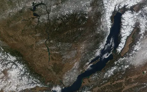
The lake curves southwest to northeast along the edge of the Siberian Platform. The administrative boundary between Irkutsk Oblast and the Republic of Buryatia crosses the water, but it does not divide the physical basin. In the 2006 bathymetric model, the deepest longitudinal route—the thalweg—runs 672 km from Kultuk in the southwest to Nizhneangarsk in the north. That is a bottom-following centerline measurement, not a straight end-to-end distance. The same study gives a maximum cross-lake width of about 73 km and a minimum of about 29 km.[2]
The northwestern underwater margin is generally steeper than the eastern margin. Olkhon Island stands beside the Central Basin, the Svyatoy Nos Peninsula projects from the eastern shore, and the broad Selenga Delta interrupts the otherwise narrow mountain-framed shoreline on the southeast side. These visible features continue underwater as fault slopes, ridges, shallow banks, canyons, and delta-built ramps.[2]
Three deep basins and two separating highs
The South, Central, and North basins are distinct depressions connected above submerged sills. The Selenga Ridge separates the South and Central basins; farther northeast, Academician Ridge separates the Central and North basins. This segmented form matters because the sills restrict exchange between the deepest water masses even though the lake surface is continuous.[3][6]
1,461 m maximum
A deep southwestern depression with very steep northern and northwestern submerged slopes.
1,642 m maximum
The deepest basin; its floor descends far below sea level east of Olkhon Island.
904 m maximum
Shallower than the other two main basins but still exceptionally deep for an inland lake.
The accepted 1,642 m maximum is a sounded water depth at 53°14′59″ N, 108°05′11″ E. With the mapped lake surface 455.5 m above the Kronstadt gauge datum, that point lies about 1,186.5 m below the datum. The 1,637 m figure still found in older sources came from a different submersible sounding; the later digital bathymetric compilation integrated 1,312,788 depth-position points and retained 1,642 m as the maximum. The values therefore record different surveys, not seasonal depth change.[2]
Extension, subsidence, and thick sediment
Baikal occupies three grabens—elongated crustal blocks lowered along normal faults as the crust stretches. Their asymmetrical form resembles half-grabens, with major fault systems controlling the steep northwestern sides. Seismic studies indicate roughly 4.4 to 10–12 km of sediment beneath the three lake depressions, so the visible water depth is only the upper part of a much deeper structural and sedimentary basin.[3]
The familiar statement that Baikal is “25 million years old” is a useful broad label, not a precisely dated creation event for the modern shoreline. A synthesis of seismic and core evidence places the start of sedimentation in and around the South and Central basins and Academician Ridge at about 27–30 million years ago. The North Basin began developing much later, around 10–7 million years ago, while accelerated rifting and changing sediment environments continued afterward. Basin formation, establishment of deep connected water, and the modern lake outline therefore occurred in stages.[4][8]
The rift remains tectonically active. Fault displacement creates steep relief and earthquake shaking; rivers and slope failures then transfer sediment into deep water. Near the Selenga mouth, delta deposition builds a broad shallow platform, while narrow canyons carry sediment downslope elsewhere. Tectonics creates accommodation space, and erosion progressively fills part of it.[2][3]
A Mongolian–Siberian catchment and one outlet
Baikal's drainage extends far beyond the Russian shoreline into northern Mongolia. A 2024 hydrological study gives about 540,000 km² for the land catchment and 31,500 km² for the lake surface. Adding the two explains the approximately 570,000 km² whole-basin figure used in some summaries: the figures describe different boundaries rather than rival estimates of one area.[2][5]
More than 300 rivers and streams enter the lake. The Selenga reaches the southeast shore after draining a large part of northern Mongolia and southern Buryatia; the Upper Angara enters the north end; and the Barguzin reaches the eastern shore. Together these three supply about two-thirds of surface inflow, with the Selenga the largest contributor. The Angara leaves near the southwestern end and carries Baikal water into the Yenisei drainage toward the Arctic Ocean.[4][5]
Tributary flow is strongly seasonal. In the 1898–2020 series analysed for the Selenga, Upper Angara, and Barguzin, 74.6% of their combined annual discharge occurred in the May–October warm season. Snowmelt and warm-season rain therefore deliver most river water and sediment, while the lake's immense storage smooths those pulses before water exits through the Angara.[5]
Baikal's level is no longer wholly natural. Backwater from the Irkutsk Hydroelectric Power Plant, 60 km down the Angara, reached the lake in 1958 and raised its average level by about 0.8 m; outlet regulation now modifies seasonal and multi-year fluctuations. Hydrological records may use the local Pacific Height System, which is about 0.5 m higher than the Baltic system in this region. A lake level is therefore incomplete without its date and vertical datum.[5]
Continental cold expressed differently across the lake
The surrounding basin has a strongly continental climate, but Baikal's length, depth, and mountain margins produce important local differences. Ice formation commonly begins in late December and the lake is usually covered by mid-January. Open water tends to reappear first in the south in early May, while remnants can persist in northern reaches until late June. Wind, currents, cloud, snowfall, river inflow, and water depth all modify that sequence, so no single freeze or breakup date represents the entire lake.[1][7]
The long Listvyanka station record, begun in 1869, shows later ice formation and reduced duration over the long term, but NASA's review cautions that one southern station cannot stand for every basin. Satellite observations have found differing timing in central and northern Baikal. The useful geographic conclusion is not that ice follows a fixed calendar, but that its duration and breakup pattern respond to regional air temperature and to local lake and weather processes.[7]
Seasonal surface layers, persistent deep stratification
Baikal's great depth changes the physics of mixing. Below roughly 250 m, the water column is weakly but persistently stratified because pressure lowers the temperature at which freshwater is densest. Surface cooling alone therefore cannot overturn the entire 1,642 m column in the same way it can mix a shallow lake.[6]
Deep water is nevertheless renewed. Cold surface water can be driven down steep coastal slopes; increasing pressure alters its density and can trigger thermobaric instability, meaning instability caused by the combined effects of temperature and pressure. These plunging intrusions replace and mix deep water below the reach of ordinary seasonal overturn. Basin depth, fault-made slopes, winter cooling, and wind are thus connected parts of one physical system rather than separate facts.[6]
From rift relief to Arctic drainage
Lake Baikal belongs in the lake hub as a freshwater body whose depth and volume are inseparable from active continental rifting. Its tributaries and Angara outlet connect it to the river systems hub; its fault scarps, submerged ridges, delta platform, canyons, and mountain margins connect it to the terrain index. The page's physical scope ends at the lake basin, while those links place it within the wider watershed and relief systems.
Sources and measurement notes
- International Lake Environment Committee, Ozero Baykal (Lake Baikal), World Lake Database (accessed 29 August 2026). Source for the recorded Russian transliteration, geographic bounds, single Angara outlet, approximate tributary count, and broad continental-climate and freeze-period context. The profile explicitly warns that its administrative place names have not been updated; this page uses the current names Irkutsk Oblast and Republic of Buryatia.
- Sherstyankin, P. P. et al., “Computer-Based Bathymetric Map of Lake Baikal”, Doklady Earth Sciences 408(4), 564–569 (2006). Source for the 1,312,788-point bathymetric model; 31,722 km² surface area; 23,615.4 km³ volume; 744.4 m mean and 1,642 m maximum depths; maximum-depth coordinates; three basin depths; 455.5 m Kronstadt-gauge reference level; 672 km thalweg length; and approximately 29–73 km cross-lake width. Surface area and volume are modelled at the stated reference level, and thalweg length is not a straight-line dimension.
- Nielsen, C. and Thybo, H., “No Moho uplift below the Baikal Rift Zone: Evidence from a seismic refraction profile across southern Lake Baikal”, Journal of Geophysical Research: Solid Earth 114 (2009). Source for the lake's position within the active rift, three grabens, Selenga and Academician ridges, controlling basement faults, approximate 660 km by 40–80 km tectonic extent, and 4.4 to 10–12 km sediment fill. The extent is a regional tectonic description; the page uses the bathymetric thalweg for its explicitly defined length measurement.
- Petit, C. and Déverchère, J., “Structure and evolution of the Baikal rift: A synthesis”, Geochemistry, Geophysics, Geosystems 7 (2006). Source for the rift's topographic setting, principal tributaries and Angara outlet, staged basin evolution, sedimentation beginning around 27–30 million years ago in the South and Central basins, and later development of the North Basin. These ages describe phases of basin and sedimentary history, not one exact birthday for the modern lake.
- Sinyukovich, V. N. et al., “The Variation in the Water Level of Lake Baikal and Its Relationship with the Inflow and Outflow”, Water 16, 560 (2024). Source for the 540,000 km² land-catchment figure, rounded lake area and volume, transboundary catchment, principal tributaries, warm- and cold-season runoff distribution, Angara outflow, Irkutsk HPP backwater and regulation, and the difference between Pacific and Baltic height systems. Its basin area excludes the approximately 31,500 km² lake surface.
- Piccolroaz, S. and Toffolon, M., “Deep water renewal in Lake Baikal: A model for long-term analyses”, Journal of Geophysical Research: Oceans 118, 6717–6733 (2013). Source for Baikal's freshwater-volume comparison, the three sub-basins and exchange-limiting sills, seasonal stratification, the approximately 250 m limit of ordinary convective mixing, and cold-water downwelling caused by thermobaric instability. The renewal model is for the South Basin and is not presented as a whole-lake event census.
- NASA Earth Observatory, “Ice Melting on Lake Baikal” (Aqua MODIS image acquired 4 May 2012; article published 10 May 2012; page updated 31 January 2026; accessed 29 August 2026). Source for the usual spatial sequence of freeze and breakup, the Listvyanka record, satellite-observed differences among lake sectors, and the weather and lake processes that alter ice duration.
- UNESCO World Heritage Centre, “Lake Baikal”, World Heritage List dossier 754 (inscribed 1996; accessed 29 August 2026). Source for the lake's internationally recognized depth, volume, antiquity, and the 8.8-million-hectare World Heritage property. The property includes extensive surrounding land and must not be confused with the 31,722 km² lake surface.