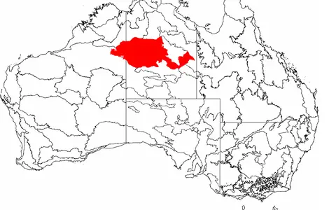

The physical desert, not every Tanami region
The recorded feature name in the Northern Territory Place Names Register is Tanami Desert. Geoscience Australia's national desert table shortens the entry to Tanami; this page treats that as a table label, not a different feature. The national table assigns the named desert 184,500 km² and places it in both Western Australia and the Northern Territory.[1][2]
Its margins are zones of transition rather than surveyed walls. Sand cover, exposed rock, drainage and rainfall seasonality grade westward toward the Great Sandy Desert and into range, basin and plateau country to the north, east and south. The published national area page does not provide a downloadable desert polygon, so this record does not invent exact corner coordinates or dimensions.
The gazetteer point at 19.25°S, 130.75°E (GDA94) identifies the registered Northern Territory feature. It is not a centroid and cannot define the interstate desert's extent. A desert is an area; a single place-name coordinate is only a locator.[2]
Named desert, bioregion and subregion
IBRA—the Interim Biogeographic Regionalisation for Australia—classifies recurring combinations of landform, geology, climate and ecosystems. IBRA 7 lists a Tanami region (code TAN) of 25,997,277 ha, or 259,972.77 km². That region comprises three subregions: Tanami Desert (TAN01), Wycliffe (TAN02) and Sandover (TAN03). Their published areas are 20,769,151 ha, 1,600,893 ha and 3,627,233 ha respectively.[3]
The similarly named TAN01 subregion converts to 207,691.51 km²—also larger than Geoscience Australia's 184,500-km² physical desert. A 2008 rangelands profile rounded the whole bioregion to 259,970 km² and estimated 88% in the Northern Territory and 12% in Western Australia.[4] Those percentages describe that edition of the bioregion, not the state split of the named desert. The small difference between 259,970 and 259,972.77 km² is retained as rounding and product precision, not averaged away.
Level sandplain with subtle landform structure
The surface is not a continuous high dune sea. Government descriptions emphasize red Quaternary sandplains, with smaller alluvial plains, low ridges and stony rises; older Permian and Proterozoic rocks appear locally as hills and ranges. Alluvial and lacustrine calcareous deposits—sediment or soil enriched in calcium carbonate—occur through the wider Tanami region.[4][5]
A 2024 peer-reviewed regolith-landform study found that most of its mapped Tanami study area has slopes below 1%, so useful relief differences may be only a few metres across broad distances. It distinguishes aeolian sandplain and dunes from pediments, alluvial fans, plains and palaeovalleys. Mapped fans are mostly 5–10 km long and wide, although some reach 20 km in each dimension; these are study-area observations, not desert-wide minima or maxima.[6]
Regolith is the loose or weathered material above coherent bedrock. Across the Tanami it includes windblown sand, sheet-flow deposits, gravelly lag, laterite, calcrete and valley fill. Wind redistributes exposed sand, while short-lived runoff carries sediment away from rocky rises and across pediments into very shallow plains and depressions. Long weathering and repeated burial have therefore subdued relief without making the surface uniform.[6]
Quaternary red sand
Sand sheets and low dunes mantle much of the older rock framework rather than forming one uninterrupted sand sea.
Mostly below 1% slope
Small gradients organize sheet flow, fans and relict valleys even where the country appears nearly level.
Rock, laterite and pans
Hills, ridges, stony rises, claypans and saline depressions break the sandplain surface.
The Tanami geological region is not the desert boundary
The exposed hills reveal only parts of an older and more complicated geological framework. Geoscience Australia's 2007 synthesis places the widespread Killi Killi Formation of the Tanami Group at about 1,840 million years old and records Tanami-region granite emplacement at about 1,820–1,795 million years ago. These are Palaeoproterozoic ages determined from isotopic dating, not an age for the modern desert surface.[7]
Younger Proterozoic successions also occur: the Pargee Group is overlain by the basal Birrindudu Group of the Victoria–Birrindudu Basin, whose opening phase probably began after about 1,700 million years ago. The desert landform cuts across this geological complexity. “Tanami Region” in geological publications refers to a crustal and stratigraphic province, while “Tanami Desert” here refers to the surface dryland; their outlines should not be assumed to coincide.[7]
Much later weathering, erosion, wind action and water movement produced the visible regolith. Rock outcrops and duricrust shed debris onto pediments; sand masks many contacts; and fine alluvial or lake sediment fills shallow depressions and old valleys. This layered history explains why ancient folded rocks, later weathering crusts and young surface sediment can appear within one low-relief view.[6][7]
Floodouts and palaeovalleys, not one river basin
The Tanami does not have one permanent through-flowing river network. Modern water movement is commonly sheet flow or brief channel flow after heavy rain. It spreads across alluvial flats and floodouts, infiltrates sandy ground, or ends in claypans, freshwater swamps and saline depressions. A floodout is where a channel loses definition and water disperses across a plain; a palaeovalley is a valley made by an older drainage system and later partly buried by sediment.[5][6]
The Lander and Hanson rivers provide eastern and southern orientation. Northern Territory wetland mapping records both as flowing north from Burt Plain country into or toward the Tanami; the Lander terminates in the Lake Surprise floodplain. In the north, Sturt Creek is associated with broad alluvial and lacustrine deposits. These systems are episodic and spatially separate, so they do not form tributaries of a single “Tanami River.”[5]
Relict drainage is more extensive than the active channel network. The 2024 landform study maps large alluvial plains as mostly relict, with little present erosion or aggradation, and identifies places where inferred palaeodrainage changes direction or ends in closed depressions.[6] Heavy rain can reactivate parts of these lows, connect pans temporarily and move fine sediment, but a buried former route does not imply continuous modern flow or an outlet to the sea.
Summer-dominant rain with different local and regional measures
The 2008 rangelands assessment classifies the Tanami bioregion as semiarid with monsoonal influence. Its spatially averaged median rainfall was 298 mm for 1890–2005, using rainfall years from 1 April to 31 March. The report warns that a single average conceals substantial spatial variability across the large region.[4]
Rabbit Flat supplies a local comparison from within the central Tanami, not a replacement regional value. Bureau of Meteorology station 015666 is at 20.18°S, 130.01°E and 340 m elevation. Its all-years table, updated through 5 February 2026, reports mean annual rainfall of 487.8 mm from 29 available years (1996–2026). The December–March monthly means total 365.5 mm—about 75% of the annual mean. The station's annual mean daily maximum is 34.0°C, with December and January means of 39.1°C and 38.8°C.[8]
The higher Rabbit Flat mean and lower historical bioregional median are not contradictory: one is a point mean with a shorter observation period, the other a spatial median over a larger boundary and earlier period. Summer thunderstorms, tropical lows and occasional inland penetration of active monsoon moisture supply much of the rain. Bureau guidance defines the Australian monsoon by a seasonal wind reversal and notes that active phases may occur between November and April; year-to-year timing and reach vary.[9] That variability produces long dry intervals interrupted by runoff events capable of filling floodouts and pans.
Wind works broadly; water works in pulses
Wind sorts and shifts exposed sand across sheets and dune crests, while vegetation and crusted surfaces limit movement over much of the ground. Rain acts less often but more abruptly: sheet flow leaves rocky rises, follows minute gradients, spreads through fans and floodouts, and deposits finer sediment in flats, valleys and pans. Evaporation then concentrates salts in closed depressions.
These processes operate on inherited terrain. A modern flood may reuse only part of a palaeovalley, while sand can obscure an old channel without removing its regional low. The result is a desert where current drainage, buried drainage and surface sediment pathways overlap but are not identical.[5][6]
Compare boundary, relief and drainage
Westward, the Great Sandy Desert provides a neighboring longitudinal-dune comparison. Its named desert and identically named IBRA region also have different extents, but its western Canning Basin framework and stronger dune grain differ from the Tanami's mixed sandplain, low rocky relief and internal floodouts.
The Simpson Desert contrasts a much more regular longitudinal-dune landscape tied to the Lake Eyre Basin. Return to the Desert Hub for category-wide navigation. These links compare physical drylands, not political areas or interchangeable bioregional polygons.
Sources and measurement notes
- Geoscience Australia, “Areas of Australian and territory deserts” (Deserts database, 1994; revised 2022; page updated 25 November 2022; accessed 29 August 2026). Source for the “Tanami” table label, WA–NT scope, 184,500-km² named-desert area and 2.4% mainland comparison. The page publishes no desert polygon, map scale or area-calculation method.
- Northern Territory Government, Place Names Register, “Tanami Desert” feature extract, place ID 18795 (extract dated 27 August 2026; accessed 29 August 2026). Source for the recorded feature name, feature type and 19.25°S, 130.75°E coordinate on GDA94. The point is retained as a place-name locator, not interpreted as a centre or perimeter.
- Australian Government Department of Climate Change, Energy, the Environment and Water, “Interim Biogeographic Regionalisation for Australia (IBRA7) Codes”, IBRA7 subregions and codes, and IBRA 7.1 region-layer metadata (accessed 29 August 2026). Source for the separate 25,997,277-ha Tanami region and the TAN01–TAN03 areas. Conversions use 100 ha per km². IBRA 7.1 is a land-surface classification, not the named-desert boundary.
- Australian Government, Rangelands 2008—Taking the Pulse: Tanami bioregion (2008). Source for the rounded 259,970-km² area, 88% NT/12% WA split, dominant sandplain and minor landforms, semiarid monsoonal classification, summer rainfall bias and spatially averaged 298-mm median for 1890–2005 using April–March rainfall years. Every value describes that bioregion and edition.
- Duguid, A., Barnetson, J., Clifford, B., Pavey, C., Albrecht, D., Risler, J. and McNellie, M., Northern Territory Government, Wetlands in the Arid Northern Territory, Volume 1, Technical Report 06/2005 (2005). Used for Tanami surface materials and wetland types, Sturt Creek deposits, the northward Lander and Hanson systems, and the Lander–Lake Surprise terminal floodplain. These drainage statements describe mapped systems, not a single desert-wide basin.
- Langford, R. L., “Geochemical Pathways Defined by Predictive Regolith-Landform Models Using TanDEM-X Data in the Tanami Region, Australia”, Earth Science, Systems and Society, volume 4 (2024), article 10111. Used for study-area slope, fan dimensions, regolith-landform distinctions, relict alluvial plains and revised palaeodrainage interpretation. The local dimensions are not promoted to desert-wide extrema.
- Neumann, N. L. and Fraser, G. L. (eds.), Geoscience Australia, Geochronological Synthesis and Time-Space Plots for Proterozoic Australia, Record 2007/06 (2007), pp. 92–93. Source for the Tanami geological region's age constraints, Tanami Group and granite chronology, and younger Pargee and Victoria–Birrindudu basin relationships. These ages describe rocks and geological events, not desert formation.
- Australian Bureau of Meteorology, “Climate statistics for Australian locations: Rabbit Flat, station 015666” (all available data; latest available data 5 February 2026; accessed 29 August 2026). Source for station coordinates, 340-m elevation, available-year counts, monthly and annual mean rainfall, and mean maximum temperatures. The 365.5-mm December–March total and 75% share are calculated from the published monthly means.
- Australian Bureau of Meteorology, “The Australian Monsoon” (accessed 29 August 2026). Used for the seasonal wind reversal, active-phase timing and northern Australian wet-season mechanism; it does not define a fixed monsoon boundary through the Tanami.