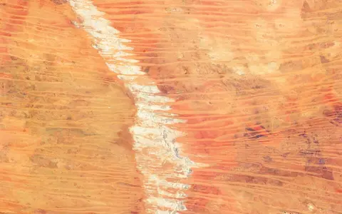

A physical desert and a larger bioregion
Geoscience Australia's area table shortens the feature name to Great Sandy. This page retains the full name Great Sandy Desert; the shortened table label is not treated as a separate feature or alias. The record places the named desert in Western Australia and gives 267,250 km².[1] The page concerns that physical desert. Where data are available only for the Great Sandy Desert IBRA bioregion, the wider scope is stated explicitly.
IBRA—the Interim Biogeographic Regionalisation for Australia—classifies recurring combinations of landform, geology, climate and ecosystems for national planning. Its Great Sandy Desert region (code GSD) comprises McLarty, Mackay, Ehrenberg, Amedeus, Lake Bennett and Lake Lewis subregions. The published areas sum to 39,486,135 ha, or 394,861.35 km².[2] A 2008 rangelands profile used an earlier 395,250-km² boundary and estimated 75% in Western Australia and 25% in the Northern Territory.[3] The 389-km² difference is retained as an edition difference, not averaged away.
A desert is an area, not a point. Neither area source identifies a surveyed centre, so this page does not manufacture a single latitude–longitude coordinate. Coordinates below locate specific measured stations or wetlands only; they must not be read as the desert's centre or limits.
From Kimberley and Pilbara margins toward the interior
The named desert occupies northern inland Western Australia. Kimberley plateau and range country lies to the north, Pilbara uplands and the Little Sandy Desert approach from the west and southwest, and the Gibson Desert lies southward. Toward the east the sand country grades into Tanami and central Australian ranges and basins. These are transition zones: dune density, exposed rock, drainage form and rainfall seasonality change across them rather than at a wall-like edge.[3][4]
The larger IBRA polygon reaches much farther east than the 267,250-km² named feature. An older Mackay subregion profile, for example, includes Northern Territory country south of the Tanami Desert and west of the MacDonnell Ranges, underlain by the Arunta Inlier and Amadeus and Ngalia basins.[4] Those eastern outliers explain why a statement true for the bioregion—such as its presence in the Northern Territory—must not automatically be assigned to the Western Australian named desert.
Sand sheets, longitudinal dunes and rocky interruptions
Quaternary red sand sheets and longitudinal dunes dominate the western desert. A longitudinal or seif dune is an elongated ridge whose crest lies broadly parallel to the net sand-moving wind regime; the term describes form, not a single modern wind direction. Interdune swales expose sandplain, clay-rich flats, salt surfaces or gravelly lag, while lateritised uplands such as Anketell Ridge, sandstone mesas, buttes and ranges break the otherwise subdued relief.[4][5]
Measurements should remain tied to their map sheets. In the western Paterson region, a Geoscience Australia synthesis reports dunes up to about 30 m high, spaced 300 m to 3 km apart, and, on the Yarrie sheet, more than 70 km long. Their dominant trend there is northwest, but orientation varies around Australia's continental dune whorl.[5] These observations replace a blanket east–southeast orientation and are not claimed as minima, maxima or a uniform alignment for the entire desert.
The same synthesis describes the ridges as partly active today and interprets stronger activity around the last glacial maximum, about 17,500–16,000 years ago. It also notes a more complex history through Pleistocene and Holocene climatic cycles.[5] In practice, vegetation stabilizes much of each ridge, while exposed crests and disturbed patches can still be reworked. The dune field is therefore inherited and intermittently modified, not a uniformly migrating sand sea.
Red sandplain
Broad sheets of quartz-rich sand form the low-gradient surface between repeated dune ridges.
Long ridges, variable spacing
Paterson measurements show why local dimensions are more useful than an unsupported desert-wide average.
Laterite and bedrock
Anketell Ridge, mesas, buttes and ranges expose the older framework beneath the sand mantle.
The Canning Basin is not the whole desert
The Canning Basin underlies much of the western Great Sandy Desert, but its area must not be used as the desert's area. Geoscience Australia maps the geological basin across about 506,000 km², including 430,000 km² onshore, with more than 15 km of sediment in its deepest northwest-trending depocentres. Deposition began with Early Ordovician extension and subsidence and continued through repeated marine, evaporitic, aeolian, river and delta environments into the Early Cretaceous.[6]
At the surface, Western Australian subregion descriptions place Quaternary dunes over Jurassic and Cretaceous sandstone, with laterite, calcrete and evaporite along older uplands and blocked drainage lines.[4] Laterite is an iron-rich weathering crust; calcrete is soil or sediment cemented by calcium carbonate; evaporites are salts left as water evaporates. These younger materials and weathering products create the visible landforms even though the basin fill beneath them is far older and much thicker.
The eastern IBRA extensions are geologically different. The Mackay profile identifies sedimentary and metamorphic rocks of the Arunta Inlier and Amadeus and Ngalia basins and gives a broad 350–800 m elevation range for its Northern Territory component.[4] That range is neither a named-desert elevation span nor evidence for the highest and lowest points of the Western Australian desert.
Modern flood pulses over relict river systems
The desert has no single permanent through-flowing river network. Most rain infiltrates sand, spreads as sheet flow, moves briefly through channels or ponds in claypans and saline basins. Along the southern and eastern margins of the wider Canning–Great Sandy study region, the Rudall River reaches Lake Dora, Savory Creek drains toward Kumpupintil Lake, and Sturt Creek terminates at the Lake Gregory system.[7] Older sources call Kumpupintil Lake “Lake Disappointment”; Landgate formally approved the restored name in 2020.[8]
Palaeovalleys are ancient drainage corridors that no longer operate as integrated rivers. Geoscience Australia's 2009 review traces the Canning (or Percival) palaeovalley westward from the Stansmore Range through the Percival Lakes, Lake Auld, Lake Blanche and Lake Dora. It also describes the Mandora palaeovalley between the Lake Gregory–Sturt Creek country and the west coast, but records competing reconstructions of several divides and connections.[7] A mapped palaeovalley therefore indicates former drainage and buried sediment, not continuous modern flow.
Lake Gregory shows how episodic inflow can create a major desert-edge wetland. A management study locates the lake complex at 20°12′S, 127°26′E, at the northern edge of the Great Sandy and Tanami deserts. Sturt Creek drains about 65,000 km² into interconnected shallow basins whose frequent-shoreline area was estimated at 38,700 ha. Mulan Lake commonly reached maximum depths of 3–4 m, reached at least 7.8 m in the largest recorded flood, and dried completely in 1979–80 and 1990.[9] Those values describe that wetland and observation history, not the desert's general lake depth.
Groundwater in the palaeovalley fill remains less well measured. The 2009 national review found few hydrogeological investigations for the Canning–Great Sandy region and warned that fresher supplies, continuity and yield had mainly been assessed around particular communities, bores and deeper rock aquifers.[7] The page therefore does not generalize a recharge rate, water-table depth or groundwater quality across the desert.
Summer-biased rain with strong spatial and year-to-year variability
The older Great Sandy Desert bioregion assessment describes an arid tropical climate in the north, grading toward temperate–subtropical aridity in the south. Its spatially averaged median rainfall was 223 mm for 1890–2005, measured by rainfall years running from 1 April to 31 March; the report explicitly warns that regional averaging conceals variation across this very large area.[3]
A local station illustrates both heat and the summer rainfall bias without standing in for the whole desert. Telfer Aero (21.71°S, 122.23°E; station elevation 292 m) reports an all-years mean annual rainfall of 367.2 mm from 52 available years between 1974 and 2026. December–March monthly means sum to 282.0 mm, about 77% of that annual mean. Its mean daily maximum is 34.2°C across 51 available years, rising to 40.3°C in January and 40.5°C in December.[10] These are station statistics with changing periods of available data, not a desert-wide climate normal or record.
The Bureau of Meteorology's 1991–2020 gridded rainfall maps place central Australian dryness under the subtropical high-pressure belt and far from dependable moisture sources. In northern Australia, most rain is associated with active monsoon phases during the October–April wet season; northwest cloudbands can also carry moisture across the interior.[11] Storm totals can produce rapid runoff and lake filling, but long dry intervals and high evaporative demand prevent a permanent integrated surface-water system.
Wind reworking and water pulses operate at different scales
Wind sorts loose sand and reshapes exposed dune crests, while vegetation and surface crusts hold much of the dune body in place. Rare heavy rain works more abruptly: it scours short channels, spreads sediment across floodouts, reconnects parts of lake chains and leaves fine clay or evaporite salts after water infiltrates or evaporates. These short events modify a landscape whose basin structure, weathering surfaces and palaeovalleys developed over far longer intervals.[5][7]
The interaction is visible where dunes cross older drainage. Sand can mask a palaeovalley without erasing the low, while floods may reuse only part of an ancient route. This is why aligned salt lakes and buried channels can coexist with modern internal drainage—and why a dry valley shown on a geological map should not be described as a present tributary.
Compare boundary, basin and dune form
Use the Gibson Desert to compare a neighboring western dryland whose physical core is lateritic plateau rather than extensive sandplain. The Simpson Desert provides a second longitudinal-dune comparison within the Lake Eyre Basin farther east.
Return to the Desert Hub for category-wide navigation. Each record distinguishes named landforms from bioregions, geological basins, drainage systems and administrative areas even when their labels overlap.
Sources and measurement notes
- Geoscience Australia, “Areas of Australian and territory deserts” (Deserts database, 1994; revised 2022; page updated 25 November 2022; accessed 29 August 2026). Source for the “Great Sandy” table label, its Western Australian scope and the 267,250-km² named-desert figure. The page publishes no polygon, scale or area method.
- Australian Government Department of Climate Change, Energy, the Environment and Water, IBRA7 subregions and codes and IBRA 7.1 Regions feature-layer metadata (accessed 29 August 2026). The published GSD01–GSD06 areas sum to 39,486,135 ha; the 394,861.35-km² figure is this page's conversion at 100 ha per km². IBRA 7.1 is the current minor update aligned for CAPAD 2024, but this page does not claim that a planning polygon is the named-desert perimeter.
- Australian Government, Rangelands 2008—Taking the Pulse: Great Sandy Desert bioregion (2008). Source for the then-current 395,250-km² bioregion area, 75% WA/25% NT split, climate transition and spatially averaged 223-mm median rainfall for 1890–2005 using an April–March rainfall year. Its area is retained as an older-edition comparison.
- Western Australian Department of Conservation and Land Management, Graham, G., Great Sandy Desert 1 (GSD1—McLarty subregion) (September 2001), and Kendrick, P., Great Sandy Desert 2 (GSD2—Mackay subregion) (November 2001), in A Biodiversity Audit of Western Australia's 53 Biogeographical Subregions in 2002. Used for mapped surface materials, Anketell Ridge, palaeodrainage names, geological contrasts and the explicitly Northern Territory 350–800-m elevation range. Superseded subregion areas in these profiles are not used.
- Roach, I. C. (ed.), Geoscience Australia, Geological and energy implications of the Paterson Province airborne electromagnetic (AEM) survey, Western Australia, Record 2010/12 (2010), regolith-landform review in section 3.3.2. Used for local Paterson/Yarrie dune height, spacing, length, northwest trend, partial modern activity and age interpretation. The measurements are map-sheet observations, not desert-wide ranges.
- Geoscience Australia, “Canning Basin: Basin details and geological overview” (updated 27 June 2014; accessed 29 August 2026). Used for the separate 506,000-km² geological-basin area, 430,000-km² onshore component, maximum sediment thickness and tectono-sedimentary history.
- Magee, J. W., Geoscience Australia, Palaeovalley Groundwater Resources in Arid and Semi-Arid Australia: A Literature Review, Record 2009/03 (2009), pp. 92–96. Used for Canning Basin–Great Sandy drainage directions, named modern terminal systems, Canning/Percival and Mandora palaeovalleys, competing reconstructions and groundwater-evidence limits.
- Government of Western Australia, “Lake Disappointment formally renamed Kumpupintil Lake” (11 November 2020; accessed 29 August 2026). Used only for the official restored name and former-name note.
- Western Australian Department of Environment and Conservation, Management Planning for Ramsar Sites in the Kimberley Region of Western Australia (2008), Lake Gregory chapter. Used for the wetland coordinate, component basins, 65,000-km² Sturt Creek catchment, 38,700-ha frequent-shoreline area, observed depths and recorded dry years. These measurements are local and historical.
- Australian Bureau of Meteorology, “Climate statistics for Australian locations: Telfer Aero, station 013030” (all available data; statistics updated through 2026; accessed 29 August 2026). Used for station coordinates, elevation, available-year counts, monthly and annual mean rainfall, and mean maximum temperatures. The 77% summer share is calculated from the published December–March means and rounded to a whole percent.
- Australian Bureau of Meteorology, “Average annual, seasonal and monthly rainfall maps” (1991–2020 gridded climatology; accessed 29 August 2026). Used for subtropical high-pressure, distance-from-moisture, northwest-cloudband and northern wet-season controls; no map-cell value is inferred for the whole desert.