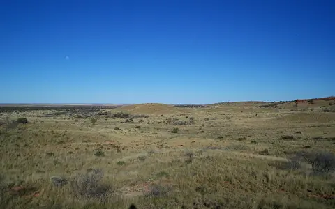

One landform, one bioregion, two localities
The Composite Gazetteer of Australia records GIBSON DESERT as a Western Australian desert landform (record WA_100132964). Its reference point is 24.11417°S, 125.85411°E in GDA94. That point locates the label; it is not a surveyed centre, boundary or elevation site. The same gazetteer separately records Gibson Desert North and Gibson Desert South as administrative localities. This page concerns the physical desert, not either locality.[1]
Two area measurements must remain separate. Geoscience Australia's named-desert list reports 156,000 km², while the current IBRA 7.1 region code GID stores 15,628,918 hectares, or about 156,289 km².[2][3] IBRA boundaries group recurring geology, landform, climate and ecosystems for national planning; they are not a legal boundary or proof of the older desert-database perimeter. No attempt is made here to average the two figures.
Between dune deserts and the Central Ranges
The IBRA 7.1 GID polygon lies wholly in Western Australia. A GDA94 envelope query places it between 21.9993° and 27.3351°S and 123.9087° and 128.7078°E; these are bounding coordinates, not length and width measurements.[3] The Great Sandy Desert lies to the north, the Little Sandy Desert to the northwest, and the Great Victoria Desert to the south. The Central Ranges—including the Rawlinson–Petermann range country—form the higher eastern transition, while Gascoyne and Murchison terrain lies westward.
The IBRA boundary is irregular because it follows mapped landscape patterns rather than latitude, longitude or an administrative line. Lateritic plains grade into neighboring sandplain, dune and range country, so a road crossing may show no abrupt edge. Kumpupintil Lake, once used loosely as a Gibson Desert example, is outside the GID polygon: its approved gazetteer point at 23.51833°S, 122.81250°E is west of the bioregion's western envelope and the national wetland directory assigns its system to the Little Sandy Desert and Gascoyne.[1][10]
Lateritic plain first, dune field second
IBRA 7.1 divides the bioregion into only two subregions. Lateritic Plain (GID01) covers 12,714,805 hectares, about 127,148 km²; Dune Field (GID02) covers 2,914,114 hectares, about 29,141 km².[4] The official areas quantify planning polygons, but their names also capture the strongest physical contrast: most of the region is gravelly upland, while dune terrain is substantial but secondary.
The state subregional audit describes GID01 as gently undulating gravelly sandplain and lateritized upland with few sandstone mesas. Laterite here means an iron-rich weathering crust, or duricrust; pisolitic gravel consists of small rounded iron-rich nodules often called “buckshot.” Erosion of the crust's margins makes breakaways—low scarps below the plateau surface—and leaves mesas, buttes and isolated sandstone ridges. The audit describes GID02 as red dune fields over older sedimentary strata, with patches of lateritized upland.[5]
A map-based geomorphic study characterized the main plateau surface at roughly 400–550 m above sea level and interpreted its laterite as the remnant of a duricrusted soil profile. It proposed that wind deflation removed loose sand from parts of the upland and redeposited it in valleys as linear ridges.[6] That is a regional reconstruction, not evidence that every dune formed at the same time or from one source.
Lateritic Plain
Gently undulating gravelly sandplain, weathering crust, breakaways and sparse sandstone mesas dominate GID01.
Dune Field
Red dune fields and sandplain define GID02, interrupted by lateritized uplands and older rock.
Plateau and remnants
A broad 400–550 m surface is dissected at its margins and locally broken by ranges, buttes and mesas.
Basin names require care
It is too simple to describe the whole desert as “Canning Basin rocks.” The 2001–02 state audit used Canning (Gunbarrel) Basin for the flat-lying Jurassic and Cretaceous sandstone beneath part of the lateritic plain, while assigning Permian Gunbarrel Basin strata beneath the dune field.[5] Beard's regional synthesis instead used “Gunbarrel Basin over Neoproterozoic Officer Basin” for much of the Gibson–Great Victoria interior and placed the Canning–Officer separation near the buried Warri Ridge.[6]
These labels refer to geological packages and interpretations at different depths and dates, not competing names for the desert. The safe physical reading is that flat-lying sedimentary rocks from several intervals underlie a much younger weathering mantle, alluvium and windblown sand. Deep basin structure supplies the rock framework; prolonged chemical weathering, stripping of softer material, wind redistribution and intermittent runoff created the landforms visible at the surface.
Short-lived flow on top of ancient valleys
No permanent river network crosses the Gibson Desert bioregion. State assessments record ephemeral creek lines and seasonal or intermittent freshwater and floodplain lakes, while the broader North Western Plateau water assessment describes all rivers in its Gibson–Great Sandy study region as ephemeral.[5][9] After heavy rain, water moves briefly through shallow channels, spreads as sheet flow or floodouts, infiltrates sandy and alluvial sediment, or ponds in claypans and lake basins. Evaporation and infiltration commonly end the event before channels connect into a sustained river.
The alignments of salt lakes and alluvial flats preserve paleodrainage: ancient river valleys that no longer function as integrated surface systems. Topographic and geological mapping reconstructs former courses through the Gibson and Great Victoria deserts, including the Throssell and Disappointment paleoriver systems, but modern lake levels, divides and sediment fill interrupt those old routes.[6] A paleoriver line is therefore evidence of former drainage direction, not a tributary carrying water today.
Buried valley sediment can still matter hydrologically. Geoscience Australia notes that paleovalley fill often stores more groundwater than adjacent weathered or fractured basement, although water quality, continuity and yield must be established locally.[7] The state audit identifies seasonal features such as Lake Gruszka and the Lake Breaden system within the lateritic subregion; they should not be generalized into permanent desert-wide water bodies.[5]
Low regional rainfall, high event variability
The rangelands assessment calculated a spatially averaged median of 163 mm across the Gibson Desert bioregion for 1890–2005, using rainfall years from 1 April to 31 March. It explicitly warns that the regional average conceals local variation.[8] This figure differs in both statistic and period from a station mean or the Bureau of Meteorology's current 1991–2020 gridded climate averages, so it is retained as a labelled historical measurement rather than presented as timeless “annual rainfall.”
Continental position and the subtropical high-pressure belt keep the interior dry for much of the year. The Bureau explains that central Australian rainfall is sparse and highly variable because the region lies far from dependable moisture sources; northwest cloudbands can carry moisture across the interior, while decayed tropical systems may deliver heavy rain far inland.[11] The North Western Plateau assessment describes erratic monsoonal influence as strongest toward the north.[9] Southern and western margins can also receive rain from cool-season systems, but no single seasonal mechanism supplies the whole mapped region reliably.
Rain pulses, sediment movement and surface change
Most geomorphic work occurs in pulses. Intense rain can erode breakaway faces, scour shallow channels, move gravel and fine sediment, and spread alluvium across low-gradient plains. Water then retreats into isolated pools, infiltrates or evaporates. On exposed dry surfaces, wind removes and sorts finer particles and reworks dune crests, while vegetation and surface crusts stabilize much of the sand between disturbance events.
These modern processes modify an inherited landscape rather than building it from scratch. The plateau weathering profile and paleovalleys developed over much longer intervals; today's floods reuse parts of old lows without restoring their former through-flow. That separation between ancient framework and episodic modern activity explains why the desert can contain conspicuous channels, lake chains and dunes despite lacking a permanent integrated river system.[6][7]
Compare surface, boundary and drainage
Use the Great Sandy Desert to compare a northern dryland with much more extensive sandplain and longitudinal-dune terrain. To the south, the Great Victoria Desert continues the old continental surfaces, dunes and paleodrainage toward the southern interior.
Return to the Desert Hub for category-wide navigation. The linked pages describe natural regions; their named-desert, bioregional, drainage and administrative boundaries should not be assumed to coincide.
Sources and measurement notes
- Geoscience Australia, Composite Gazetteer of Australia, feature layer (accessed 29 August 2026). Queries used the approved Western Australian records WA_100132964 (GIBSON DESERT), WA_100190542 (GIBSON DESERT NORTH), WA_100190553 (GIBSON DESERT SOUTH) and WA_100010102 (KUMPUPINTIL LAKE). The point coordinates are GDA94 locations supplied for place-name mapping and are not polygon centroids or navigation coordinates.
- Geoscience Australia, “Areas of Australian and territory deserts” (Deserts database, 1994; revised 2022; page updated 25 November 2022; accessed 29 August 2026). Source for the 156,000-km² named-desert figure. The page supplies no polygon, scale or area method.
- Australian Government Department of Climate Change, Energy, the Environment and Water, IBRA 7.1 Regions feature layer, code GID, and “Australia's bioregion framework” (version 7.1 aligned for CAPAD 2024; accessed 29 August 2026). The layer stores 15,628,918.477 ha; an envelope query transformed to GDA94 returned 21.99927–27.33507°S and 123.90871–128.70778°E. Envelope limits are not desert length or width.
- Australian Government Department of Climate Change, Energy, the Environment and Water, IBRA 7.1 Subregions feature layer (accessed 29 August 2026). GID01 Lateritic Plain stores 12,714,804.851 ha and GID02 Dune Field 2,914,113.626 ha; percentages on this page are calculated against their 15,628,918.477-ha sum and rounded to whole numbers. A GDA94 envelope query places GID02 in the northeastern part of the bioregion.
- Western Australian Department of Biodiversity, Conservation and Attractions, Regional Profile Gibson Desert GD (dataset issued 2025 from field and staff interpretations compiled July 2001–January 2002), especially the Gibson Desert 1: Lateritic Plain and Gibson Desert 2: Dune Field profiles. Used for subregion-specific terrain, shallow rock terminology, ephemeral drainage and named seasonal features. Their superseded subregion areas and unperiodized 200-mm rainfall estimates are not used.
- Beard, J. S., “Palaeogeography and drainage evolution in the Gibson and Great Victoria Deserts, Western Australia”, Journal of the Royal Society of Western Australia 85, 17–29 (2002). Used for the 400–550-m generalized plateau, relief and deflation interpretation, basin-naming caveat, and reconstruction of paleodrainage from 1:250,000 topographic and geological maps. The article supplies no vertical datum for its elevations.
- Geoscience Australia, “Palaeovalleys” (updated 27 June 2014; accessed 29 August 2026). Used for the definition of inactive, sediment-filled ancient valleys and the qualified groundwater-storage comparison with adjacent basement aquifers.
- Australian Government, Rangelands 2008—Taking the Pulse: Gibson Desert bioregion (2008). Source for the 156,290-km² then-current bioregion summary and the spatially averaged 163-mm median rainfall for 1890–2005, measured by April–March rainfall year. Current area comes from IBRA 7.1 instead.
- Bureau of Meteorology, Australian Water Resources Assessment 2012, North Western Plateau region chapter (2013). This broader water-assessment region includes major parts of the Great Sandy and Gibson deserts; its statements about ephemeral rivers and erratic monsoonal influence are not treated as measurements of the GID polygon alone.
- Australian Government, A Directory of Important Wetlands in Australia, third edition, Western Australia listing (2001; accessed 29 August 2026), Lake Disappointment (Savory Creek) System entry WA052. The directory assigns that system to the Little Sandy Desert and Gascoyne bioregions; the lake's official name is now Kumpupintil Lake.
- Australian Bureau of Meteorology, “Average annual, seasonal and monthly rainfall maps” (1991–2020 gridded climatology; accessed 29 August 2026) and “Tropical cyclones” (accessed 29 August 2026). Used for the subtropical-ridge, distance-from-moisture, northwest-cloudband and inland decaying-tropical-system controls; no map-cell value is inferred for the whole desert.