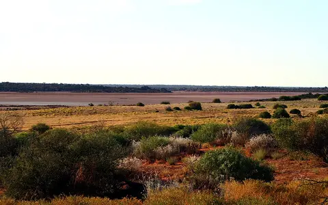

One desert, two commonly quoted boundaries
This page concerns the physical Great Victoria Desert. Geoscience Australia's area table shortens the name to Great Victoria and assigns the feature 348,750 km² across Western Australia and South Australia.[1] The shortened table label is not treated here as a separate feature or an alternative boundary.
The identically named IBRA region is a biogeographic classification based on recurring combinations of climate, geology, landform, vegetation and species. Its six published subregions are Shield, Central, Maralinga, Kintore, Tallaringa and Yellabinna. Their listed areas sum to 42,246,563 ha, equivalent to 422,465.63 km² at 100 ha per km².[2] A 2008 rangelands profile used an earlier 418,750-km² IBRA boundary and placed 52% of it in Western Australia.[3] The 3,715.63-km² difference is an edition difference; the figures are not averaged.
A desert is an area rather than a survey point. None of these national sources publishes a single coordinate as the physical desert's centre, so this page does not invent one. The coordinate given later belongs only to the Maralinga weather station.
Between the goldfields, Musgrave country and the Nullarbor
The desert crosses the Western Australia–South Australia border in the southern interior. In Western Australia its western edge meets the East Murchison and Eastern Goldfields country; the Gibson Desert and Musgrave Ranges lie northward, and the Nullarbor Plain borders it to the south. East of the state line, the Maralinga, Kintore, Tallaringa and Yellabinna IBRA subregions carry the same regional name across western South Australia.[2][4]
These are physical transitions, not a wall-like perimeter. Dune fields extend toward adjoining sand country, while the Nullarbor's limestone surface, northern ranges and western cratonic rocks interrupt or redirect the sandy mantle. The Murray–Darling Basin is not an immediate margin of this desert and is therefore omitted from the boundary description.[2]
Repeated ridges over a subdued plateau
Sandplains and mostly east–west longitudinal dunes dominate the mapped Shield and Central subregions. A longitudinal dune is an elongated ridge aligned broadly with the net sand-moving wind regime. Ring and irregular network dunes also occur, especially over palaeodrainage depressions, so the desert is not one uniform field of parallel ridges.[4]
Measurements compiled for those two western subregions give a mean dune height of about 10 m, a typical range of 2–15 m, lengths of 1.5–5 km and widths of 100–200 m; interdune corridors are reported as 250–800 m wide. The same assessment places much of those sandplains at about 350–500 m Australian Height Datum (AHD), locally dropping to 300 m or less.[4] These are regional design values, not the highest, lowest, longest or widest features across the whole Great Victoria Desert.
Interdune surfaces expose red sandy earth, gravel pavement, clay-rich lows, calcrete and salt pans. Resistant laterite and silcrete form flat-topped mesas, buttes and breakaways in the west; sandstone or quartzite outcrops add further local relief.[4]
Quaternary aeolian cover
Wind-deposited quartz sand blankets older rock and sediment without erasing the underlying valleys.
Low, elongated ridges
Western measurements show kilometre-scale dune length but metre-scale height.
Duricrust and bedrock
Laterite, silcrete, sandstone and quartzite create harder islands within the sandplain.
Several geological provinces beneath the sand
The visible dune cover is young compared with its foundation. In the west it crosses granite and greenstone of the Yilgarn Craton and metamorphic rocks of the Albany–Fraser Province. Farther east, Quaternary sand covers sedimentary rocks of the Gunbarrel and Officer basins; younger Eucla Basin deposits approach the southern margin.[4][6]
The Officer Basin must not be used as a proxy for desert size. Geoscience Australia describes it as a separate 410,000-km² intracratonic basin spanning Western Australia and South Australia, with as much as 10 km of Neoproterozoic-to-Late-Devonian sediment. Its fill records river, shallow-marine, carbonate, evaporite and glacial environments, later affected by the Petermann Ranges, Delamerian and Alice Springs orogenies.[5]
The modern surface developed through a much later sequence: deep weathering and duricrust formation, early Cenozoic river incision and sedimentation, then increasing aridity, salt weathering and aeolian burial. In its South Australian discussion, Geoscience Australia reports dunes up to about 7 m high and optically stimulated luminescence ages of about 200,000 years from two sites.[6] The dated sites show that some dune bodies are old, but they do not date the entire dunefield or conflict with the broader 2–15-m western height range.
Salt-lake chains preserve older river routes
The Shield and Central assessment records no permanent creek, lake or river. Heavy rain can produce substantial flow, but generally only every few years, for short periods and in limited channel reaches. Water spreads across flats, infiltrates sand and fractured rock, or terminates in internally drained playas where evaporation concentrates salt.[4]
Palaeovalleys are buried or partly buried valleys left by river systems that no longer operate as integrated surface drainage. Geoscience Australia's synthesis traces an early Cenozoic network from the eastern Yilgarn, Musgrave Province and Gawler Craton toward the Eucla Basin. Named remnants include the Throssell, Baker, Kadgo and Waigen palaeovalleys in Western Australia; Serpentine Lakes across the state border; and the Noorina, Lindsay, Merramangye and Tallaringa systems in South Australia. Dunes obscure much of this network, and later crustal movement diverted or severed some routes.[6]
Modern playa chains reuse only parts of those lows. The western regional inventory includes Serpentine, Wanna, Waigen, Kodga, Baker, Throssell–Yeo, Rason and Minigwal lake systems; Plumridge and several other lakes lie on or just outside the mapped bioregion edge.[4] At Yeo Lake, two short southern inflows—about 20 km and 15 km—feed an episodic pan that once belonged to the southeast-flowing Throssell Palaeoriver. Its inundated depth was estimated at no more than 0.1 m, but the report explicitly says water-regime data are lacking.[4]
Aridity at a summer–winter rainfall transition
The Bureau of Meteorology's modified Köppen products classify Australian desert climates from gridded rainfall and temperature data. Its 1991–2020 rainfall maps explain the dry interior through persistent subtropical high pressure and distance from dependable moisture sources. Northwest cloudbands can carry moisture across the continent; southern frontal systems contribute more during April–November toward the desert's southern side.[8]
The historical rangelands assessment gives a spatially averaged median of 162 mm for the older Great Victoria Desert bioregion over 1890–2005, using rainfall years from 1 April to 31 March. It warns that averaging conceals substantial spatial variation.[3] That median should not be presented as a station mean, a current 30-year normal or the rainfall at every point.
Maralinga illustrates the distinction. The Bureau station is at 30.16°S, 131.58°E and 290 m elevation. Across 56 available years between 1955 and 2022, its all-years mean annual rainfall is 223.6 mm. The published monthly means sum to 118.5 mm for October–March and 105.5 mm for April–September, showing that both warm-season systems and cooler-season fronts matter at this eastern site.[7] These station figures do not redefine the desert-wide median.
Rare runoff acts quickly; landscape change is slow
Short rain events and long geological intervals operate together. A storm can fill a claypan, move sand and silt through a short channel, or connect adjacent lake floors. Evaporation then removes the surface water and leaves fine sediment, gypsum or salt. Over longer spans, repeated wind deposition mantles the valleys while groundwater continues to move toward playa discharge zones or deeper into the Eucla Basin.[4][6]
This layered history explains why a salt-lake chain may mark a former through-flowing river even though its modern basin is internally drained. It also sets the evidence limit: mapped palaeovalleys do not prove present surface flow, and local dune ages, heights or groundwater depths should not be generalized across 348,750 km².
Compare plateau and dune-field deserts
Use the neighboring Gibson Desert to compare a dryland with a stronger lateritic-plateau identity. The Simpson Desert offers another Australian longitudinal-dune system, but within the Lake Eyre drainage setting farther east.
Return to the Desert Hub for category-wide navigation. Each record keeps physical deserts separate from bioregions, sedimentary basins and drainage systems that share or overlap their names.
Sources and measurement notes
- Geoscience Australia, “Areas of Australian and territory deserts” (Deserts database, 1994; revised 2022; page updated 25 November 2022; accessed 29 August 2026). Source for the “Great Victoria” table label, Western Australia–South Australia scope, 348,750-km² area and ranking within the agency's mainland-desert list. The summary publishes no polygon, map scale or area method.
- Australian Government Department of Climate Change, Energy, the Environment and Water, IBRA7 subregions and codes and IBRA 7.1 Regions feature-layer metadata (accessed 29 August 2026). The department's published IBRA7 table gives GVD01–GVD06 areas totalling 42,246,563 ha; 422,465.63 km² is this page's conversion at 100 ha per km². The metadata identifies IBRA 7.1 as the current minor update aligned with CAPAD 2024; this page does not infer a revised area from that metadata or treat the IBRA polygon as the named-desert perimeter.
- Australian Government, Rangelands 2008—Taking the Pulse: Great Victoria Desert bioregion (2008). Source for the then-current 418,750-km² bioregion area, 52% Western Australian share and spatially averaged 162-mm median rainfall for 1890–2005 using an April–March rainfall year. Its area is retained as an older-edition comparison.
- Great Victoria Desert Biodiversity Trust, A biodiversity conservation plan for Shield and Central subregions of the Great Victoria Desert: Review of literature and research records (undated compilation containing records through 2016; accessed via the Western Australian Department of Biodiversity, Conservation and Attractions library, 29 August 2026), especially pp. 7–19. Used for regional position, dune geometry and AHD elevations, surface materials, geological contrasts, lack of permanent surface water, named lake chains and the Yeo Lake example. Its measurements are limited to the Shield and Central subregions unless the report states otherwise.
- Geoscience Australia, “Officer Basin: Basin details and geological overview” (page updated 27 June 2014; accessed 29 August 2026). Used for the separate 410,000-km² basin area, maximum 10-km sediment thickness, age span and tectono-sedimentary history.
- Magee, J. W., Geoscience Australia, Palaeovalley Groundwater Resources in Arid and Semi-Arid Australia: A Literature Review, Record 2009/03 (2009), pp. 161–165. Used for the former Eucla Basin drainage network, named cross-border palaeovalleys, later diversion and burial, two-site dune height and optically stimulated luminescence age, and modern groundwater direction. Conflicting palaeodrainage reconstructions noted by the report are not collapsed into a single certain route.
- Australian Bureau of Meteorology, “Climate statistics for Australian locations: Maralinga, station 018114” (all available data; statistics prepared 20 August 2026; accessed 29 August 2026). Used for station coordinates, elevation and monthly and annual mean rainfall. The two six-month totals are sums of the published rounded monthly means; available-year counts vary by element.
- Australian Bureau of Meteorology, “Average annual, seasonal and monthly rainfall maps” (1991–2020 gridded climatology) and “Climate classification maps” (modified Köppen and seasonal-rainfall products; accessed 29 August 2026). Used for the classification method, subtropical high-pressure and moisture-distance controls, northwest cloudbands and southern frontal rainfall. No single map-cell value is assigned to the whole desert.