
One desert, several different “Sechuras”
This record uses Sechura Desert for the physical coastal dryland; Desierto de Sechura is its Spanish name. It does not use the name as shorthand for Sechura Province, the town of Sechura, Sechura Bay, or the Sechura sedimentary basin. Those features overlap spatially but have different boundaries. The geological basin, for example, extends offshore and has been measured to a 1,000-m submarine contour, so its published 30,000 km² area cannot be assigned to the land desert.[8]
The sources used here do not converge on one desert polygon. A recent coastal field study describes the Sechura between 6° and 7°S, from the Pacific to the Andes, while a continent-scale sediment study uses “Sechura desert” for 4.5–7°S.[1][4] The wider window reaches north of the central landform region and serves a different research purpose. This page therefore reports those frames as study extents and gives no unsupported centre coordinate, length, width or total area.
Plain, rocky massif and rising eastern margin
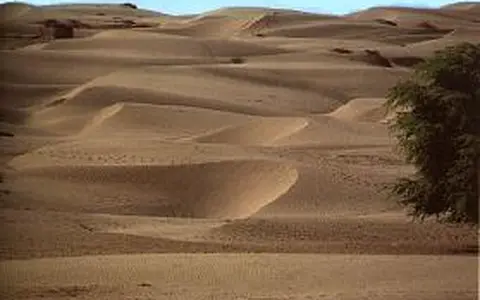
The dominant landform is a wide, low-gradient coastal plain. Regional Piura mapping places the western plain below about 400 m above sea level and generally below 5° of slope; loose to semi-consolidated alluvial, fluvial and aeolian sand and gravel cover much of it.[3] “Aeolian” means moved or reworked by wind. The desert is therefore not a single dune sea: river-built flats, sand sheets and dunes, saline lows, beach ridges and exposed older sediment all occur across the same plain.
At the coast, Sechura Bay opens north of the Illescas peninsula and massif. Illescas is the principal rocky interruption in the plain, with short dry gullies, steep coastal slopes and small embayments such as Nunura Bay. A 1993 NASA oblique photograph recorded peninsula relief of about 480 m and southwest-to-northeast wind streaks across the surrounding desert.[1][12] Eastward, vegetation and channel integration increase as the land rises toward the western Andes; that transition is gradual rather than a wall-like desert edge.
Pacific margin
Sechura Bay, beach ridges, bay-margin flats and former shorelines connect the desert to coastal sediment transport.
Sedimentary lowland
Sand, alluvium and poorly drained depressions form the broad floor crossed by the lower Piura system.
Illescas and Andes
The rocky Illescas Massif interrupts the coast; the opposite margin rises into Andean piedmont and headwater terrain.
A desert surface above a marine sedimentary basin
The underlying Sechura Basin is one of the sedimentary basins of the Peruvian continental margin. A stratigraphic study treated its onshore portion at 5–7°S as a shelf basin within the Andean forearc—the zone between the ocean trench and the volcanic arc—and found discontinuous marine deposition since the middle to late Eocene. At least four Cenozoic marine transgressions, when the sea advanced across the basin, deposited sequences that include sandstone, siltstone, mudstone, diatom-rich sediment and phosphate-bearing beds.[8][9]
That long basin history explains why a modern desert contains extensive marine sediment and economically important evaporitic and biogenic layers, but it should not be confused with formation of the present dryland. The modern surface is much younger and is assembled from uplifted marine platforms, river and flood deposits, windblown sand, salt crusts and shoreline barriers. The metamorphic Illescas Massif exposes the older structural frame at the basin's western side.[1][8]
Terraces and a closed palaeolagoon
A marine terrace is a former wave-cut or wave-built shoreline platform now standing above the sea. In the World Atlas of Last Interglacial Shorelines database, shoreline angles assigned to Marine Isotope Stage 5e—about 125,000 years ago—are 18 ± 3 m above sea level at Illescas and Bayóvar; mapped terrace elevations across the Illescas Peninsula decrease southward from roughly 30 to 17 m.[11] These are elevations of dated shoreline markers, not a minimum-to-maximum elevation claim for the whole desert.
Farther south on the Las Salinas Noroeste plain, sedimentary facies reconstruct a lagoon with restricted marine connection between the third and eighth centuries CE. Fine marine sediment alternated with coarser continental input, and evaporation left salt crusts. Researchers attribute the system to a shore bar that had been building since at least the middle Holocene; after freshwater input diminished and longshore drift closed the remaining inlet, the lagoon dried.[10] The record shows that the desert's saline flats are products of changing shorelines, barriers, runoff and evaporation—not simply hollows between dunes.
The Piura ends in a mutable lowland system
The Piura River is an Andean-to-coastal drainage, not a stream generated only by rain falling on the desert. Peru's National Water Authority (ANA) defines the river at the union of the Bigote and Canchaque–Huarmaca rivers. Its approved 2015 assessment delineates a 10,872.1 km² watershed and a 243 km main channel; the Bajo Piura unit accounts for 4,721.5 km² and has a reported mean elevation of 92 m.[5] Every one of those figures describes the watershed or river, not the Sechura Desert.
The lower course has shifted across very gentle terrain. A regional water-management report describes the former outlet near the San Pedro estuary and a later route in which surplus water passes through the Ramón, Ñapique and Las Salinas depressions before reaching the Virrilá estuary.[6] That older report used a 12,216 km² basin and a 280 km river to Virrilá, whereas the approved 2015 assessment used nine sub-basins and the smaller figures above. Because the delineations and channel endpoints are not identical, their totals are presented separately rather than averaged.
Additional drainage is intermittent. The Cascajal crosses west from the Andean side but can lose its visible channel in permeable desert sediment under dry conditions; short quebradas descend from Illescas.[1][12] During large rainfall events these disconnected pathways can become a temporary network, spreading water and sediment across playas and enclosed lows.
What the 2017 lagoon measurement means
Laguna La Niña is an episodic flood-water body, not a permanent lake and not a synonym for the Sechura Desert. During the 2017 Coastal El Niño it began forming in late January as flows increased in the Piura, Cascajal and Motupe systems. IMARPE mapped it daily with 500-m MODIS-Aqua imagery, calculated water area using a satellite index and estimated volume against the ASTER global elevation model.[7]
The mapped area peaked at 2,172 km² on 5 April 2017, with an approximate volume of 5.18 × 10⁹ m³. By 4 November the water area had contracted by 34.1%. The same study reports a larger estimated maximum of 2,326 km² for 1997–98.[7] These values are event-specific remote-sensing estimates: spatial resolution, water classification and the elevation model affect them, and they should not be quoted as fixed lake dimensions.
The geomorphic effect outlasts the water. Floods erode channels and fan surfaces, carry Andean sediment into the lowlands, deposit mud in shallow basins and then expose it to drying, salt concentration and wind deflation. Across western Peru, monitored catchments carried 3–60 times their normal annual suspended-sediment yield during the extreme 1982–83 and 1997–98 El Niño events, with the largest response in northern catchments; that regional result explains the strength of the process but is not a measured sediment rate for the desert floor itself.[4]
Why normal years are dry
Sechura lies where the cold, northward Peru–Humboldt Current and coastal upwelling meet the influence of warmer equatorial water. Cool sea-surface conditions support stable lower air and a coastal low-level jet; the Southeast Pacific High, divergent winds over the coastal plain and the Andes' barrier effect further suppress deep convection. A coast-to-Andes station study also found an extended sea-breeze circulation and strong local topographic controls.[1][2]
The resulting rainfall gradient is steep. The 2020 national classification reproduced in recent Piura flood research assigns about 20–50 mm of annual precipitation to the Sechura Desert, rising to 700–900 mm in interior and highland parts of Piura.[3] A separate observational study gives about 15 mm per year at coastal Paita and about 700 mm at Morropón, 148 km inland; these are place-specific reference values, not endpoints of a uniform desert transect.[2]
During eastern-Pacific or Coastal El Niño conditions, abnormally warm nearby water and changed winds weaken the normally stable coastal regime. Moist convection can then develop over the plain, most often in the austral late-summer rainy season, and runoff rises sharply. Local coastal warming and rain do not always track the basin-wide ENSO index exactly, so “El Niño” should not be treated as one fixed rainfall amount or recurrence interval.[1][2]
The northern end of Peru's coastal dry belt
Sechura belongs to the broader Pacific-margin dryland between ocean and Andes, but its northern latitude gives it stronger exposure to eastern-equatorial Pacific variability than the hyperarid core farther south. The Atacama Desert offers the closest along-coast comparison; the Namib Desert shows a separate cold-current desert system on the Atlantic margin.
What distinguishes Sechura in the Desert Hub is not an unsupported size record. It is the close coupling of a broad, low coastal plain, a sediment-filled forearc basin, inherited marine shorelines, an Andean river and event-scale flood lakes.
Sources and measurement notes
- Villa, V. et al., “Settlement dynamics, subsistence economies and climate change during the late Holocene at Nunura Bay (Sechura Desert, Peru): A multiproxy approach”, PLOS ONE 18, e0281545 (2023). Used for the 6–7°S research frame, Piura–Lambayeque and Pacific–Andes setting, BWh classification, ocean-current transition, Illescas–Nunura geography, quebradas and El Niño landscape response; the article's climate-data.org monthly values are not used here.
- Rollenbeck, R., Bayer, F., Münchow, J., Richter, M., Rodriguez, R. & Atarama, N., “Climatic Cycles and Gradients of the El Niño Core Region in North Peru”, Advances in Meteorology 2015, 750181 (2015). Observational basis for the coastal jet, sea breeze, pressure and topographic controls, seasonal rainfall mechanism, Paita–Morropón rainfall contrast and warning that local warm-water rain can depart from basin-wide ENSO.
- Badillo-Rivera, E. et al., “Flood susceptibility mapping in El Niño Phenomenom integrating multitemporal radar analysis, GIS and machine learning techniques, Piura river basin, Peru”, Frontiers in Environmental Science 13, 1672107 (2025). Used for the mapped Piura coastal-plain relief, broad surface-material classes and the 20–50 mm/yr Sechura range reproduced from SENAMHI's 2020 climate classification; the range is regional, not a station normal.
- Morera, S. B., Condom, T., Crave, A., Steer, P. & Guyot, J. L., “The impact of extreme El Niño events on modern sediment transport along the western Peruvian Andes (1968–2012)”, Scientific Reports 7, 11947 (2017). Used for the wider 4.5–7°S Sechura usage and the event-based, regionally measured suspended-sediment response; its catchment factors are not presented as a Sechura-specific sediment rate.
- Autoridad Nacional del Agua, Evaluación de los recursos hídricos superficiales en la cuenca del río Piura, approved by Resolución Directoral No. 005-2015-ANA-DCPRH (2015), vol. I. Source for the nine-sub-basin delineation, 10,872.1 km² watershed, 243 km channel, Bigote–Canchaque-Huarmaca origin and Bajo Piura measurements.
- Autoridad Autónoma de la Cuenca Hidrográfica Chira–Piura, Plan Regional de Reforestación y Conservación de Suelos en las Cuencas Hidrográficas de la Región Piura (2007). Used for the lower Piura's historical outlet relationship and its older 12,216 km²/280 km measurement convention; these totals are retained only to explain why they differ from the approved 2015 assessment.
- Escudero Herrera, L. & Xu, H., “Formación y evolución de la Laguna La Niña 2017, utilizando imágenes satelitales Modis-Aqua”, Boletín Instituto del Mar del Perú 34(1), 105–114 (2019). The 2017 area was derived daily at 500-m resolution with MODIS-Aqua and NDVI; volume used ASTER GDEM. Dates, contraction and the separately estimated 1997–98 maximum are reported as event measurements.
- Kingston, J., Undiscovered Petroleum of Southern South America, U.S. Geological Survey Open-File Report 94-559 (1994), “Sechura Basin” section. Used to distinguish the 30,000 km² geological-basin area—measured partly offshore to the 1,000-m isobath—from the land desert, and for the broad sedimentary and structural framework.
- Dunbar, R. B., Marty, R. C. & Baker, P. A., “Cenozoic marine sedimentation in the Sechura and Pisco basins, Peru”, Palaeogeography, Palaeoclimatology, Palaeoecology 77, 235–261 (1990). Source for the 5–7°S onshore shelf-basin scope, Cenozoic marine transgressions, depositional gaps and sediment types.
- Christol, A. et al., “The Las Salinas palaeo-lagoon in the Sechura Desert (Peru): Evolution during the last two millennia”, The Holocene 27(1) (2017; first published online 10 May 2016). Source for the third- to eighth-century lagoon facies, salt-crust phases, middle-Holocene shore-bar development, restricted marine connection and final closure.
- Freisleben, R., Jara-Muñoz, J., Melnick, D., Martínez, J. M. & Strecker, M. R., “Marine terraces of the last interglacial period along the Pacific coast of South America (1°N–40°S)”, Earth System Science Data 13, 2487–2513 (2021). Source for the MIS 5e shoreline-angle elevations at Illescas/Bayóvar and their southward pattern; values describe former shoreline markers above sea level.
- NASA Johnson Space Center Earth Science and Remote Sensing Unit, “Sechura Desert, Peru”, Earth from Space image STS056-075-015, acquired 10 April 1993. Used for the photo-specific 480-m peninsula relief, southwest-to-northeast wind streaks and visible Cascajal channel loss; the image centre at 5.5°S, 80.5°W is not treated as the desert's coordinate.