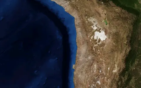

A desert region, not one basin
“Atacama” does not describe a surveyed polygon with one official area. Researchers select different north–south limits according to climate, landforms, geology, or biological communities. A rainfall study, for example, used 18–26°S, while Chilean coastal-relief mapping treated 18.5–28°S as Atacama terrain.[1][2] Giving either window as the desert's exact boundary would confuse a study area with a physical edge.
This record concentrates on the Chilean forearc: the strip from the Pacific coast across the Coastal Cordillera and Central Depression to the Precordillera, or lower western approach to the Andes. The adjacent Altiplano is higher and generally wetter; it supplies water and sediment to some desert basins but is not interchangeable with the hyperarid core. Broader literature continues the Atacama north into southern Peru, while its southern transition toward the Copiapó sector becomes progressively less hyperarid.[2][3]
Coastal wall, interior depression, Andean rise
At the western edge, a high coastal escarpment rises abruptly above the Pacific. Inland lies the Coastal Cordillera, a long structural ridge rather than a low sand plain. Regional Chilean mapping gives much of the range a width of 20–40 km and mean elevations near 1,500–2,000 m; Sierra Vicuña Mackenna, near 24.5°S, reaches about 3,100 m in that mapping.[2]
East of the coastal range, the ground descends or opens into the Central Depression. Broad pampas, gravel surfaces, alluvial fans, shallow closed depressions, and saline crusts occupy this interior corridor. Farther east, the Precordillera and Western Cordillera rise toward the Andes. The sequence creates sharp gradients over a short west–east distance: marine fog reaches selected coastal slopes, the enclosed interior is extremely dry, and precipitation rises rapidly with elevation toward the Andean crest.
Pacific and coastal escarpment
Cold coastal water, low cloud, marine terraces, and a steep mountain front define the ocean margin.
Pampas and closed lows
Long-lived surfaces, fans, dry channels, salt crusts, and salars occupy the forearc interior.
Precordillera and Andes
Rising terrain intercepts more moisture and sends episodic runoff and groundwater toward lower basins.
An uplifted forearc with sediment-filled lows
The desert occupies the forearc of the Central Andes, the part of the continental margin between the Peru–Chile Trench and the Andean volcanic arc. Subduction has built and deformed this margin over a long interval, but the surface is not one rock unit. Along the coast north of about 25°S, Jurassic andesitic rocks record an older magmatic arc; farther south, granodiorite, gabbro, and related intrusive rocks become prominent. North–south faults of the Atacama Fault System cut the Coastal Cordillera.[2]
Between the rocky belts, tectonic subsidence and uneven uplift created accommodation space for continental sediment. Streams and debris flows issuing from higher ground spread gravel, sand, and mud into the Central Depression and the basins farther east. Volcanic ash and ignimbrite arrived from Andean eruptions. Where drainage ended internally, repeated evaporation retained chloride, sulfate, nitrate, and other soluble salts instead of exporting them to the sea.[2][4]
Extreme aridity slows soil production, chemical weathering, and ordinary river erosion. It therefore preserves abandoned channels, old fan surfaces, fault scarps, and salt-rich soils for unusually long periods. The result is not a landscape without change, but one in which long intervals of near-stasis are punctuated by tectonic displacement, wind transport, and rare episodes of runoff.[6][7]
Closed catchments, groundwater, and the Río Loa
The Atacama Desert is divided among many catchments. In an endorheic basin, water drains toward an internal low rather than the ocean; in the driest arreic terrain, channels are too discontinuous to form an integrated outlet at all. Runoff from the Andes and Precordillera commonly spreads through quebradas and alluvial fans, infiltrates coarse sediment, or terminates in a salar, playa, wetland, or shallow aquifer.[4]
The Pampa del Tamarugal and the basins of the Antofagasta interior contain prominent saline terminal surfaces. The Río Loa is the major regional exception: its connected drainage crosses the desert between the northern and southern groups of interior basins and reaches the Pacific. That contrast is why the Atacama should not be described as a single closed basin.[4]
Salar de Atacama is a specific pre-Andean salt basin southeast of the driest coastal core, not an alternative name for the desert. SERNAGEOMIN places its saline system at about 2,300 m, between the Cordillera de Domeyko and the Andes, and reports approximately 3,000 km² for the saline surface within an 18,100 km² catchment. Those are compiled system and basin areas, respectively—not Atacama Desert area. The source sheet gives horizontal coordinates in the PSAD56 datum but does not identify a vertical datum for the stated elevation.[5]
Why the interior receives so little rain
Several controls reinforce one another. The desert lies beneath the descending branch of the subtropical circulation, where sinking air inhibits deep cloud growth. Offshore, the northward Peru–Chile, or Humboldt, Current and coastal upwelling keep sea-surface temperatures low. Cool air near the ocean is capped by warmer air above, producing a temperature inversion and a persistent deck of low stratocumulus rather than frequent rain-bearing convection.[3][6]
The Andes add an eastern barrier. Moisture arriving from the tropical interior of South America produces much more precipitation at high elevations, but little survives the crossing into the lower forearc. A synthesis for the hyperarid core reports mean annual precipitation rising from less than 20 mm near 2,300 m to more than 300 mm near 5,000 m. The core below roughly 2,300 m receives less than 2 mm in the same regional treatment.[7] These are elevation-dependent regional values, not a single rainfall normal for every place called Atacama.
Fog and rain must also be separated. When the marine low-cloud deck meets the Coastal Cordillera it becomes advective fog. Coastal ridges and low passes determine where that moisture reaches land. The fog belt can therefore be damp while the interior beyond the range receives almost no measurable rain.[3]
Rare rainfall does disproportionate geomorphic work
Hyperarid does not mean rain never falls. Rainfall mechanisms vary with latitude and season. Summer moisture is more influential toward the northern and eastern margin, where air can approach from east of the Altiplano. Farther south, winter frontal systems and cut-off lows can carry Pacific moisture northward. A 1982–2017 model-and-observation study found this strong regional and seasonal heterogeneity rather than one Atacama rainfall regime.[1]
When an uncommon storm crosses a surface with sparse vegetation and abundant loose sediment, short-lived streams can cut channels, activate alluvial fans, transport debris, and pond in closed lows. Sediment cores from a Coastal Cordillera basin show that even the 19–22°S core experienced wetter and drier phases during the past 215,000 years. Those layers record local runoff; they should not be treated as proof that high-Andean lakes, coastal fog, and the desert interior varied in the same way at the same time.[6]
No single agreed “birth date”
Different evidence dates different aspects of aridity. Desert-like sediment can show that a dry depositional setting existed, while a dated soil mineral, abandoned surface, or exposure age tests a different process and geographic area. Uplift of the Andes and development of the modern Pacific circulation intensified the rain-shadow and temperature-inversion controls, but neither supplies a universally accepted start date for the whole desert.
A 2026 study measured cosmogenic neon-21 in 135 locally derived quartz clasts from low-relief surfaces in the northern Coastal Cordillera. Thirty-two clasts yielded model exposure durations of Oligocene age or older, and several results were consistent with surface residence since the middle Eocene. The authors interpret the preservation as evidence that extreme landscape stability began earlier than major Miocene Andean uplift and the modern Humboldt Current.[7]
This result materially revises the chronology of the sampled hyperarid core, but it does not demonstrate an unchanged, continuously hyperarid climate across every Atacama subregion since the Eocene. The sampled surfaces, model assumptions, and geographic reach matter. “One of the oldest deserts” is therefore a useful shorthand only when followed by the evidence and its limits, not an exact record claim.
Coast, desert, and Andes in one transect
The Atacama belongs in the Desert Hub as a narrow continental-margin desert whose internal geography cannot be explained by latitude alone. Ocean temperature, atmospheric subsidence, coastal relief, Andean elevation, tectonic basins, and drainage isolation combine across the same transect.
The Andes record provides the larger mountain setting. For another cold-current coastal desert, the Namib Desert is a useful comparison; for the transition north along the Pacific margin, see the Sechura Desert. These are process comparisons, not claims that their boundaries or climate regimes are identical.
Sources and measurement notes
- Reyers, M., Böhm, C., Knarr, L., Shao, Y. & Crewell, S., “Synoptic-to-Regional-Scale Analysis of Rainfall in the Atacama Desert (18°–26°S) Using a Long-Term Simulation with WRF”, Monthly Weather Review 149, 91–112 (2021). The 10-km model was evaluated against observations for 1982–2017; its coordinate window is used here as a research frame, not a desert boundary.
- Riquelme, R. et al., “Tectonic and climatic effects in the morphologic configuration of the coastal relief of northern Chile”, Andean Geology 37(1), 78–109 (2010). Source for the 18.5–28°S mapping extent, Coastal Cordillera dimensions and elevations, mapped rock units, faults, and coastal geomorphology.
- del Río, C. et al., “Spatial distribution and interannual variability of coastal fog and low clouds cover in the hyperarid Atacama Desert”, Plant Systematics and Evolution 307, 58 (2021). Source for broader southern Peru–northern Chile usage and for the ocean–inversion–topography controls on coastal fog.
- Stoertz, G. E. & Ericksen, G. E., Geology of Salars in Northern Chile, U.S. Geological Survey Professional Paper 811 (1974). Regional reconnaissance source for Central Depression sediment, interior drainage, salars, and the Río Loa division; older place descriptions are used only for stable physical relationships.
- Servicio Nacional de Geología y Minería (SERNAGEOMIN), “Salar de Atacama: ficha técnica compilada” (technical sheet accessed 29 August 2026). The sheet reports a 3,000 km² saline system, an 18,100 km² catchment, approximately 2,300 m elevation, and PSAD56 horizontal coordinates; its geology incorporates the 1:100,000 map by Becerra, Henríquez & Arriagada (2014).
- Ritter, B. et al., “Climatic fluctuations in the hyperarid core of the Atacama Desert during the past 215 ka”, Scientific Reports 9, 5270 (2019). Source for the 19–22°S core, precipitation and elevation gradient, closed-basin record, and wetter–drier phases; figures describe measured and reconstructed quantities separately.
- Ritter-Prinz, B. et al., “Evidence for Eocene aridification of the Atacama Desert's hyperarid core”, Nature Communications 17, 4520 (2026). Version of record published 20 May 2026; source for the 19–23°S core, below-2,300-m precipitation context, cosmogenic-neon sample count, model exposure durations, and revised chronology.