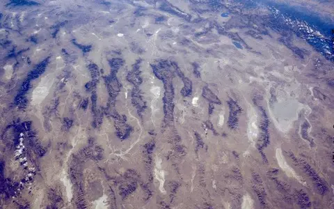

Desert, drainage region, and geologic province
“Great Basin Desert” is the accepted common name for the cold-desert region. It is not simply an alias for the Great Basin. The National Park Service separates three useful definitions: the desert is biological, the Great Basin is most commonly hydrographic, and Basin and Range describes the faulted topographic and geologic province.[1] This page treats the desert as the ecological feature and uses the other two regions only to explain its setting.
No agency source used here supplies one surveyed desert polygon, official centroid, or agreed area. A point coordinate would falsely imply that an extensive ecological transition has a single location. The approximately 200,000 sq mi (518,000 km²) figure often associated with the name belongs to the hydrographic Great Basin, whose surface water drains internally; it must not be reported as the area of the Great Basin Desert.[1]
EPA mapping offers a repeatable ecological frame rather than a synonym. In Nevada, the cold-desert terrain falls mainly within the Central Basin and Range and Northern Basin and Range Level III ecoregions; the Mojave Basin and Range is mapped separately to the south. BLM notes that the cold-to-warm desert transition is expressed by a shift from sagebrush communities toward creosote bush and Joshua tree, so it is a vegetation and climate transition rather than an administrative line.[2][3]
Between the Sierra Nevada and Wasatch front
The core extends across much of northern and central Nevada into western Utah. The Sierra Nevada forms the dominant western moisture barrier; the Wasatch Range marks the eastern side of the commonly used hydrographic frame, and the Snake River Plain lies along its northern side. Ecological Great Basin communities continue through parts of southeastern Oregon, southern Idaho, and eastern California, while the southern margin grades into the warmer Mojave Desert.[1][2]
These limits do not follow state borders. Nor does every highland inside the regional outline remain desert: climate and vegetation change sharply with elevation. Basin floors support salt-desert shrub, sagebrush, bare playa, and wetland patches; higher slopes can carry pinyon-juniper woodland, montane forest, and alpine communities. The desert is therefore a three-dimensional mosaic, not a flat expanse between mountain edges.[1][3]
Extension built the basin-and-range pattern
Crustal extension—pulling apart of the upper crust—broke and tilted blocks along normal faults. Relative uplift exposes bedrock in long ranges while adjacent blocks subsided and accumulated sediment. A USGS structural synthesis found that many Great Basin valleys can be interpreted as grabens, or down-dropped blocks, separated by horsts or tilted mountain blocks; the generally north-trending grabens were commonly spaced 15–20 mi (24–32 km) apart, though local patterns are more complex.[4]
Modern USGS province mapping places the principal phase of distributed Basin and Range extension within roughly the past 17 million years and recognizes 200 or more surface hydrographic areas across the broader U.S. Basin and Range study region.[5] Those counts and dates describe the province-scale framework, not a census or “age” of the Great Basin Desert itself. Climate aridity, faulting, drainage rearrangement, and sedimentation developed on different timescales.
Streams leaving steep canyon mouths lose gradient and spread gravel and sand into triangular alluvial fans. Neighboring fans may merge into a bajada, a continuous apron along a range front. Finer silt and clay travel farther toward the valley low, where temporary ponding and evaporation make playas and salt flats. EPA mapping distinguishes these surfaces: Nevada salt-desert units include nearly level playas and mud flats around 4,250–6,000 ft (1,295–1,830 m), while adjacent basin and slope units climb above them.[3]
Fault scarp and fan head
Bedrock relief supplies coarse debris; short, steep channels deliver it from canyons to the valley margin.
Fans and bajadas
Gravel and sand spread downslope, with younger channels repeatedly shifting across fan surfaces.
Playa and terminal wetland
Fine sediment, dissolved salts, and episodic water gather at the lowest available surface outlet.
Closed at the surface, connected below ground
Endorheic means that surface drainage ends inland. Runoff may stop in a dry sink, briefly flood a playa, feed a marsh, or enter a permanent terminal lake. Named terminal points include the Great Salt Lake, Pyramid Lake, and Humboldt Sink.[1] On the western margin, the Truckee River runs about 120 mi (193 km) from Lake Tahoe through Reno to Pyramid Lake; most of its flow comes from Sierra Nevada snowpack, while the Nevada part of its basin lies in the Sierra rain shadow.[6]
Closed surface drainage does not mean impermeable basin walls. Water infiltrates mountain blocks, alluvial fans, and basin fill. In eastern Nevada and western Utah, fractured and solution-enlarged limestone and dolomite can carry groundwater beneath topographic divides; the USGS cautions that the location and magnitude of some interbasin flow remain poorly known.[7] Springs can therefore mark a groundwater connection that is invisible in a surface-drainage map.
Terminal lakes respond strongly to the balance between inflow and evaporation. Great Salt Lake, for example, has no ocean outlet and its post-Bonneville history is a sequence of fluctuations rather than a stable shoreline. A USGS synthesis places most of its post-Bonneville elevation history between about 1,271 and 1,285 m, while emphasizing that short-lived excursions and the jagged historical record make any single “normal” level misleading.[8] Playa flooding is likewise seasonal and episodic; when dry, fine exposed sediment may be reworked by wind.[3]
Rain shadow plus elevation
Pacific air loses substantial moisture as it crosses the Sierra Nevada and, farther north, the Cascade system. Descending air warms and dries on the leeward side. Distance from the Pacific and the shelter of successive ranges reinforce that first rain shadow, but elevation redistributes the remaining moisture: high ranges receive more precipitation and retain winter snow, while enclosed lowlands are drier.[1][3]
“Cold desert” refers to the region's freezing winters and frequent cold-season snow, not to cool conditions throughout the year. Summers on basin floors are hot and dry. EPA's Nevada map reports 5–10 in/yr (127–254 mm/yr) for shadscale-dominated saline basins and 8–12 in/yr (203–305 mm/yr) for mapped sagebrush basins and slopes; higher mountain units reach much wetter classes.[3] These unit ranges are more informative than one desert-wide rainfall average because relief changes climate over short horizontal distances.
Seasonal water movement follows the same elevation contrast. Snowmelt sustains some range streams and recharges fans and bedrock, whereas many basin-floor channels flow only after storms or melt events. Intense runoff can carry high sediment loads, cut new fan channels, and pond on closed lows; long dry intervals then expose the deposited mud and salts.[3]
Shorelines above modern desert floors
During wetter Pleistocene intervals, effective moisture was sufficient for large pluvial lakes—lakes enlarged by a cooler and/or wetter climate—to occupy many western and eastern basins. Lake Lahontan linked several western Nevada subbasins; Lake Bonneville spread across the eastern Great Basin. Their beach ridges, terraces, fine lake sediment, and carbonate deposits now stand above or beyond modern lakes and playas.[3]
Pyramid Lake preserves a direct part of the Lahontan record: USGS dates major tufa growth there to roughly 26,000–13,000 years ago, when Pyramid Lake was incorporated within pluvial Lake Lahontan.[9] In the east, USGS places the end of Lake Bonneville and beginning of the Great Salt Lake system at about 13,000 years before present.[8] These dates concern particular lake histories; they do not date the origin of the desert as a whole.
As lake surfaces contracted, their exposed beds supplied the flat lacustrine sediment, salts, and shoreline forms now embedded in the desert landscape. Modern terminal lakes and intermittent playas are therefore not isolated curiosities: they are smaller, variable expressions of the same enclosed topography under the present water balance.
A region linked by relief and internal drainage
The Great Basin Desert belongs in the Desert Hub as a cold, high-relief dryland rather than a dune-defined sand desert. Compare its winter cold and sagebrush lowlands with the warmer Mojave Desert to the south. The Sierra Nevada page explains the western rain-shadow barrier, while the Great Salt Lake record follows one major terminal system within the wider hydrographic setting.
Sources and measurement notes
- U.S. National Park Service, “The Great Basin”, Great Basin National Park (updated 22 April 2021). Source for the ecological, hydrographic, and geologic distinction; the approximately 200,000 sq mi hydrographic area; internal drainage; named margins and terminal points; and the rain-shadow and elevation setting.
- U.S. Bureau of Land Management, “BLM Nevada Native Plants Program” (accessed 29 August 2026). Source for agency usage of Northern and Central Basin and Range as the cold-desert Great Basin, its multi-state extent, and the sagebrush-to-Mojave vegetation transition.
- Bryce, S. A. et al., Ecoregions of Nevada: summary tables, U.S. Environmental Protection Agency and U.S. Geological Survey, map scale 1:1,350,000 (2003; accessed 29 August 2026). Source for Level III/IV ecological units and the stated elevation, mean-annual precipitation, drainage, surface-material, vegetation, and pluvial-lake ranges. Values describe named Nevada map units, not the whole desert.
- Stewart, J. H., “Basin and range structure: A system of horsts and grabens produced by deep-seated extension”, Geological Society of America Bulletin 82, 1019–1044 (1971), doi:10.1130/0016-7606(1971)82[1019:BARSAS]2.0.CO;2. Source for the fault-block interpretation and typical 15–20 mi graben spacing; the paper also records alternative structural interpretations and local complexity.
- Solano, F., Mars, J. C. & Hubbard, B. E., Spectral Characteristics and Mapping of Lithium-Rich Playas in the Basin and Range Province, Western United States, U.S. Geological Survey Scientific Investigations Map 3554 (2026). Province-scale source for the late-Cenozoic extensional framework, 200-plus surface hydrographic areas, closed valleys, and playa setting; these province figures are not presented as a desert boundary.
- U.S. Geological Survey Nevada Water Science Center, “Science in the Truckee River Basin” (published 4 November 2024; accessed 29 August 2026). Source for the Truckee River's 120 mi course from Lake Tahoe to Pyramid Lake, Sierra Nevada snowmelt contribution, and Nevada rain-shadow context.
- U.S. Geological Survey Water Resources Mission Area, “Karst Aquifers: Basin and Range and Bear River Range Carbonate Aquifers” (20 July 2021). Source for mountain-front recharge, fractured carbonate aquifers, groundwater movement across basin divides, and uncertainty in the location and magnitude of interbasin flow.
- Oviatt, C. G., Atwood, G. & Thompson, R. S., “History of Great Salt Lake, Utah, USA: Since the termination of Lake Bonneville” (2021), doi:10.1007/978-3-030-66576-0_8. Source for the approximately 13,000-year transition from Lake Bonneville, the variable post-Bonneville record, and the qualified 1,271–1,285 m elevation envelope.
- Benson, L. V., The Tufas of Pyramid Lake, Nevada, U.S. Geological Survey Circular 1267 (2004), doi:10.3133/cir1267. Source for Pyramid Lake's inclusion in pluvial Lake Lahontan and the approximately 26,000–13,000-year interval of major tufa formation.