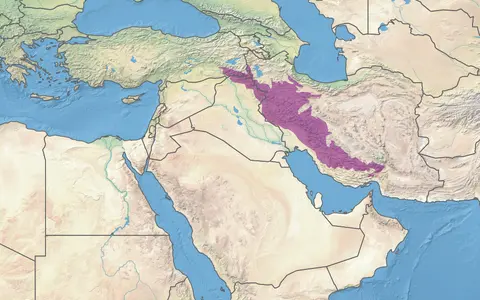

A range, a fold belt, and a wider orogen
Zagros Mountains is the conventional English name. A 2025 UK Permanent Committee on Geographical Names factfile gives Persian Kūhhā-ye Zāgros, Kurdish Çiyakan-î Zagros, and Arabic Silsilat Zāghrūs for the transboundary feature. Its listed point, 34°00′50″ N, 48°24′08″ E, is a gazetteer location for finding the range; it is not a centroid, summit, endpoint, or surveyed boundary. (PCGN, 2025)
This record covers the physical mountain range and the closely overlapping Zagros Fold and Thrust Belt, the frontal deformed part of the Arabia–Eurasia collision zone. The wider geological Zagros orogen may also include the Sanandaj–Sirjan Zone and the Urumieh–Dokhtar Magmatic Arc farther northeast. Those units help explain the collision, but they are not silently added to every range width, area, or elevation stated here. Likewise, the Mesopotamian foredeep is the low basin in front of the belt, not part of the mountains themselves. (Sembroni and others, 2024)
Different endpoints produce different lengths
A 2019 seismotectonic study traces the mountains for about 1,600 km from the Turkish border southeast to the Gulf of Oman. A 2024 review uses about 2,000 km for the broader southwest-verging orogen from eastern Türkiye to the Makran area. These are rounded along-strike extents under different geological scopes, not rival tape measurements of one crest. The page therefore does not average them or assign a whole-range area from an unreferenced polygon. (Karasözen and others, 2019; Sembroni and others, 2024)
Northwest of Iran, Zagros structures continue through Iraqi Kurdistan toward the Bitlis collision zone and the Taurus Mountains; naming and tectonic divisions overlap in this transition. Southeastward, the belt curves through Fars toward the Strait of Hormuz and merges into the Makran transition rather than ending at a single cape. Across strike, the high Iranian Plateau lies east and northeast, while the Mesopotamian Basin, Khuzestan lowland, Persian Gulf, and Gulf of Oman occupy the foreland side to the west and southwest.
Width also depends on which structural strip is measured. In the 2024 synthesis, the discontinuous High Zagros is a narrow belt about 80 km wide with average elevation of roughly 1.5–2 km. The lower Simply Folded Belt extends about 100–200 km southwest from the High Zagros Fault; the arcuate Fars domain locally reaches about 280 km across. None of those values is a uniform width for the entire named range. (Sembroni and others, 2024)
High thrust country behind long folded ridges
The northeastern side contains older, more deformed rocks and steep reverse faults in the High Zagros. Regional studies place maximum High Zagros elevations at approximately 4,000 m, but this is a generalized topographic value rather than a surveyed range high point. No precise highest-summit figure is given here because the reviewed authoritative sources do not expose a primary summit survey, method, or vertical datum. (Karasözen and others, 2019)
Southwest of the High Zagros Fault, the Simply Folded Belt is dominated by elongated anticlines—rock layers arched upward—and synclines, layers folded downward. In the 2019 synthesis, some fold arrays extend for as much as about 200 km, with typical half-wavelengths near 10 km. A separate range-wide review derives approximately 20–25 km between successive folds from balanced cross-sections. The two figures describe related but different geometries and are not interchangeable. (Karasözen and others, 2019; Sembroni and others, 2024)
Along strike, broad outward bulges and inward embayments break up the repeating ridge pattern. The principal domains include the Kirkuk embayment and Lorestan arc in the northwest, the Izeh zone and Dezful embayment in the central belt, and the Fars arc in the southeast. These are tectonic and physiographic subdivisions, not provinces or drainage basins, although their structure strongly influences both relief and river courses.
A thick marine cover with several weak layers
Before collision, the northeastern Arabian margin accumulated a thick succession of shallow- and deeper-marine sediment. Carbonate rocks—limestone and dolomite—form many resistant ridges, including units such as the Asmari and Ilam–Sarvak formations. Marl, shale, sandstone, conglomerate, and evaporites weather or deform differently, producing alternating ridges, valleys, and lowlands rather than uniform limestone terrain.
Compression does not simply crumple the whole stack as one block. Weak salt, gypsum, and shale horizons act as detachments: layers along which stronger beds can slide and fold independently of deeper rocks. In the Fars domain, the 2024 review describes a 10–12 km Phanerozoic sedimentary pile above roughly 2 km of salt-bearing Hormuz evaporites. Those thicknesses apply to that structural domain, not the entire Zagros. Salt can also rise through overlying rock as a diapir, locally disturbing fold geometry and reaching the surface. (Sembroni and others, 2024)
Carbonate ridges
Limestone and dolomite commonly hold up steep fold limbs, escarpments, and gorge walls.
Salt, gypsum, shale, and marl
Ductile or erodible units let adjacent beds detach, fold at different scales, or weather into valleys.
Fans and conglomerates
Erosion transfers debris from rising folds into piedmont fans and the subsiding foredeep.
Neotethys closure followed by continuing collision
Northward subduction consumed the Neotethys Ocean between Arabia and Eurasia; oceanic rocks were emplaced onto the Arabian margin before continental collision. The exact start of collision remains debated because different evidence records different stages. The 2024 review notes published ages from the Late Cretaceous to Pliocene, while several recent studies place initial collision in the Late Oligocene and the onset of widespread outer-belt folding in the Early to Middle Miocene. Reporting one exact “birth date” for the whole range would conceal that uncertainty. (Sembroni and others, 2024)
Collision is ongoing. GPS-based syntheses estimate active Zagros shortening at roughly 3–6 mm/year in the western belt and 6–10 mm/year in the east. A calibrated catalogue study relocated about 2,500 earthquakes from roughly 70 years of instrumental records and found most events on reverse faults within or beneath the folded sedimentary cover; its well-constrained focal depths span about 4–25 km. These measurements describe deformation rates and earthquake sources, not a uniform uplift rate for every ridge. (Karasözen and others, 2019; Sembroni and others, 2024)
Shortening varies along strike and between basement and cover. In southeastern sectors, weak Hormuz salt helps decouple folding above from faulting below; in the northwest, oblique convergence also drives right-lateral motion along the Main Recent Fault. This is why a simple label such as “two plates pushed up limestone” is incomplete: inherited basin geometry, rock strength, salt distribution, basement faults, erosion, and river incision all affect the modern relief.
Structural valleys, water gaps, and three outlet directions
The drainage network commonly has a trellis pattern: main channels follow long synclinal valleys, while short tributaries descend fold flanks and meet them at sharp angles. Where a river maintains incision across a rising anticline it forms a narrow water gap; where fold growth outpaces incision, the channel may be diverted around a fold nose and leave a dry former gap. Wetter northwestern catchments more often cut anticlines, whereas drier Fars rivers are more readily deflected. (Sembroni and others, 2024)
On the northwestern and western side, the Greater Zab, Lesser Zab, and Diyala connect Zagros headwaters to the Tigris–Euphrates River System and Mesopotamia. In central and southwestern Iran, the Karkheh, Dez, Karun, Marun, and Zohreh transfer runoff toward Khuzestan and the northern Persian Gulf. Farther southeast, rivers including the Mand and Kul cross Fars toward the Gulf, while other streams end in closed Iranian Plateau basins.
That last distinction matters: the topographic divide does not simply follow the highest crest. The 2024 synthesis separates Central Plateau internal drainage from the Persian Gulf–Oman Sea watershed and identifies about 10,000 km² of internally drained terrain in the Niriz, Shiraz, and smaller Fars basins. The figure measures those mapped closed basins, not the entire Zagros interior. (Sembroni and others, 2024)
Folded limestone stores water below the divides
Fractures and dissolution enlarge flow paths through limestone and dolomite, creating karst aquifers. Water infiltrates high ridges, moves through joints and cavities, and returns at springs along fold limbs or where permeable carbonate meets less permeable rock. Consequently, a groundwater catchment can cross the surface divide drawn from contours, and spring flow may integrate rain and snowmelt from several connected structures.
A 2023 isotope and hydrochemistry study in the Izeh zone provides a local, measured example. Samples from the Mongasht, Shavish–Tanosh, and Kamarderaz anticlines and the Naal-e-Asbi syncline indicated recharge from high-altitude rain and snowmelt in the Mongasht structure and hydraulic connections among neighboring karst aquifers. This result describes the Izeh study area; it does not prove that every Zagros anticline shares one connected aquifer. (Kalantari and others, 2023)
The same structural alternation that organizes surface relief therefore also compartmentalizes groundwater. Ilam–Sarvak and Asmari limestone–dolomite units can transmit water, while marls, shales, and evaporites can restrict or redirect it. Springs sustain some river flow beyond the rainy season, but storage and discharge vary with fracture connectivity, antecedent wetness, snow accumulation, and the position of each fold.
Winter storms, orographic lift, and a dry summer
Most precipitation arrives in the cool season as Mediterranean-origin cyclones and westerly or southwesterly airflows cross the region. Air forced upward over the northwest–southeast barrier cools and produces orographic precipitation. Elevation turns part of that moisture into snow; high ground above about 2,000 m carries seasonal snowpack that delays runoff into spring. Western and high slopes are generally wetter than sheltered eastern basins, while much of the southeastern folded belt is arid or semi-arid. (Bozkurt and others, 2021; Encyclopaedia Iranica, 2004)
Mountain-wide rainfall averages would hide this gradient. A regional synthesis reports that exposed highlands can exceed 1,000 mm/year, but values decline sharply toward leeward basins and southern lowlands; station period, elevation, and exposure are essential to any local comparison. Summer is broadly dry, so runoff shifts from rain and snowmelt peaks toward groundwater-supported flow in some carbonate catchments and intermittent flow in drier channels.
Not every major event follows the seasonal average. A 1979–2017 reanalysis study found that narrow corridors of tropical and subtropical moisture—atmospheric rivers—can cross North Africa and intensify precipitation against the Zagros. Warm air during such events may combine rain with rapid snowmelt, increasing discharge and flood risk. This process helps explain episodic high flows without treating the whole range as uniformly wet. (Bozkurt and others, 2021)
Fold growth competes with rivers and slopes
Rivers strip softer marl and shale from fold flanks, cut resistant carbonate where stream power is sufficient, and carry the debris toward piedmonts and foreland basins. Short, intense storms can mobilize large sediment pulses in otherwise dry channels. Where confinement relaxes at the mountain front, gravel and finer material spread into alluvial fans; repeated fan building shifts channels and grades the transition from ridge front to plain.
The drainage network is geologically young. The 2024 review links its development to the last few million years, when the deforming belt emerged from marine conditions and the active front migrated southwestward. Rivers inherited or established across early low-relief surfaces have since been diverted, entrenched, or abandoned as folds lengthened. The present pattern is therefore a moving balance among uplift, fold propagation, bedrock resistance, water supply, and sediment load rather than a fixed set of valleys. (Sembroni and others, 2024)
For atlas context, compare the neighboring Taurus Mountains without merging the two named systems, follow Zagros-fed tributaries into the Tigris–Euphrates River System, or return to the Mountain Hub. The Dasht-e Kavir lies farther inside Iran and is a distinct set of closed salt basins, not the eastern drainage basin of the entire Zagros.
Data sources and publications
- Permanent Committee on Geographical Names. Iraq: Toponymic Factfile, updated November 2025, pp. 13–14. Conventional English name, Persian, Kurdish, and Arabic forms, feature classification, and representative coordinates. The coordinates are a reference point, not a boundary or summit.
- Karasözen, E., Nissen, E., Bergman, E. A., and Ghods, A. “Seismotectonics of the Zagros (Iran) From Orogen-Wide, Calibrated Earthquake Relocations,” Journal of Geophysical Research: Solid Earth 124 (2019), 9109–9129. About 1,600 km study extent, High Zagros relief, fold geometry, sediment thickness, deformation rates, and calibrated earthquake depths.
- Sembroni, A., Reitano, R., Faccenna, C., and Callieri, P. “The geologic configuration of the Zagros Fold and Thrust Belt: an overview,” Mediterranean Geoscience Reviews 6 (2024), 61–86. Broad-orogen extent, tectonic domains and widths, stratigraphy, collision-age uncertainty, salt detachment, topography, drainage, river–fold interaction, and sediment transfer.
- Bozkurt, D., Sen, O. L., Ezber, Y., Guan, B., Viale, M., and Caglar, F. “Influence of African Atmospheric Rivers on Precipitation and Snowmelt in the Near East's Highlands,” Journal of Geophysical Research: Atmospheres 126 (2021), e2020JD033646. 1979–2017 reanalysis context for Zagros orographic precipitation, high-elevation snowpack, and rain-on-snow events.
- Kalantari, N., Sajadi, Z., Charchi, A., and Mousavi, S. S. “Assessment of the hydrogeochemical and isotopic characterization and hydraulic behavior of the Izeh complex karstic area, Khuzestan province, southwest Iran,” Acta Carsologica 52(1) (2023). Local evidence for high-altitude rain and snowmelt recharge and hydraulic connections among folded carbonate aquifers.
- Ehlers, E. “Hydrology ii. Southwestern Persia,” Encyclopaedia Iranica, published 2004, updated 2013. Regional orientation for the Persian Gulf drainage, winter precipitation gradient, snowmelt, transverse rivers, and carbonate springs; historical discharge values on that page are not used as present-day measurements here.