
Desert, watershed, and playa are different extents
Dasht-e Kavir is the conventional map name for the wider desert region; English sources also use Great Salt Desert and the Persian form Kavir-e Namak. Great Kavir or Kavir-e Bozorg more specifically denotes the largest northern barren basin and playa complex. This record uses Dasht-e Kavir for the regional desert and Great Kavir for that measurable core rather than treating the names as interchangeable polygons.[2]
The words also describe different landforms. A dasht is an open plain or gently sloping gravel piedmont, whereas a kavir is a fine-grained, saline playa surface of clay, silt, and salts. The compound place-name does not mean that the entire region is one salt pan: fans, rock outcrops, dunes, wet mud, and crusted playa occupy separate belts.[3]
There is no authoritative surveyed polygon for the whole desert in the checked sources, so this record does not assign it a total area. The USGS value of 200,747 km² measures the surrounding watershed, while the 350-by-150-km description applies to the completely barren Great Kavir core. Neither should be relabeled as a precise total desert area.[1][2]
From the Alborz divide to the closed basin floor
The Great Kavir watershed occupies the northeastern quadrant of Iran. Its northwestern drainage divide rises in the Alborz Mountains, and the desert core lies roughly 300 km east-southeast of Tehran. Runoff descends from higher ground across coalescing alluvial fans toward interior sumps—the lowest parts of closed basins—rather than crossing the Alborz to the Caspian drainage or flowing to the ocean.[1][6]
Across a north-to-south transect, mountain valleys and fan heads give way to gentler piedmonts, fan deltas, wet zones, and salt-crust basins. Exposed ridges and salt domes interrupt the nearly level interior; dune fields concentrate mainly along the southern and southeastern border of the mapped Great Kavir. Farther southeast, Iran's arid interior continues toward Dasht-e Lut, but the Lut is a separate basin and desert record, not the downstream end of the Kavir watershed.[1][2]
A mapped mosaic, not a uniform salt sheet
A USGS field and Landsat-1 interpretation, published in 1977 and generalized at 1:2,500,000, divided the Great Kavir surface into six classes: salt crust 41%, exposed Miocene saliferous rocks 35%, dune fields 13%, fan deltas 5%, wet zones 4%, and clay flats 2%. These values sum to the mapped core, not the 200,747 km² watershed, and they should be read as a reconnaissance classification rather than a current high-resolution land-cover inventory.[1]
The crusted areas occupy several distinct downwarps rather than one level floor. The USGS estimated the larger middle salt-crust basin at about 850 m altitude and reported that adjacent salt surfaces can stand at different levels and may be hydrologically independent. No vertical datum was named, so 850 m is retained as a source estimate, not a survey-grade elevation for the desert as a whole.[1]
Salt crust and wet mud
Fine sediment, shallow brine, and repeated crystallization produce smooth plates, buckled polygons, damp zones, and rough salt ridges.
Fans and fan deltas
Channels spread gravel, sand, and silt onto fans; where fan toes are inundated, sediment is deposited around delta-like margins.
Dune fields
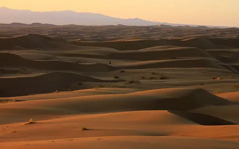
Wind reworks available sand chiefly along the south and southeast, so dunes form one sector of the system rather than its dominant cover.
Brief inflow, groundwater rise, and evaporative loss
Streams entering the interior are intermittent, and there is no outlet to the sea. Rain and upland runoff can cross the fans, spread over fan toes, or reach the playa, but much water infiltrates or evaporates before forming a persistent channel. In the USGS basin model, shallow groundwater in permeable fan sediment is unconfined; toward the centre, clay layers can confine deeper water. Groundwater approaching the playa margin helps create a wet zone where the fan aquifer meets the low surface.[1]
Capillary rise then draws saline groundwater toward the ground surface. Evaporation removes water but leaves halite and other dissolved minerals behind. Winter rain can dissolve part of an older crust; later drying precipitates it again. The result is a moving boundary among shallow brine, soft saline mud, clay flat, and hard salt rather than a permanently dry pavement.[1][2]
Salt-crust texture records the water regime beneath it. Where dark, water-saturated mud lies under thick white crust, heating and pressure can force mud through polygon cracks; rapid evaporation builds dark salt dikes and jumbled plates. The 1977 survey measured local relief of roughly 30–50 cm among resulting salt ridges and pinnacles. This centimetre-scale roughness describes selected crust fields, not regional topographic relief.[1]
Miocene evaporites, diapirs, and a younger playa surface
The salt exposed around the Great Kavir has a deeper history than the modern crust. Geological work interprets the Great Kavir as an intracontinental rift basin filled by several kilometres of Eocene-to-Recent marine and continental sediment. Thick middle Miocene evaporites accumulated in fault-bounded sub-basins during restricted marine inflow, evaporation, and later continental deposition.[4]
Salt is less dense and mechanically weaker than most overlying sedimentary rock, so buried evaporite moved upward as diapirs—salt bodies that pierce or deform their cover. Field observations and remote mapping documented more than 50 diapirs in the northern Great Kavir; twelve coalesced near the surface into an exposed salt canopy. Folding, faulting, uplift, and erosion have since revealed their internal structures.[5]
Those Miocene salt bodies must not be confused with every white playa surface. Modern crust also forms when present-day drainage dissolves salts from basin rocks and sediment, carries ions toward the sump, and loses water by evaporation. The landscape therefore combines inherited evaporite geology with an active surface hydrology.[1][4]
Cool-season precipitation in a persistent water deficit
A regional synthesis places typical annual precipitation in the central Iranian desert basins below 100 mm, much of it in the cooler months and with large year-to-year gaps. The source also cautions that older desert records are inadequate, so this is a regional climatic range rather than a modern station normal for a single point in Dasht-e Kavir.[2]
The Alborz intercepts moisture on its northern slopes and sharply limits its movement south into the basin; the Zagros similarly weakens moisture-bearing westerlies farther west. Clear dry conditions and strong summer evaporation maintain a water deficit in the interior through all seasons. Rain is rare, but not geomorphically trivial: short floods recharge fans, move sediment, inundate low crusts, and initiate the next dissolution–crystallization cycle.[1]
Iran's salt-basin desert
Dasht-e Kavir belongs in the Desert Hub as a mountain-fed, internally drained salt-desert system. Its most informative spatial sequence runs from the Alborz divide across piedmont fans and wet fan toes to the multi-level salt basins, then toward southern dune fields.
The Dasht-e Lut offers the closest regional comparison. Both occupy Iran's arid interior and lack ocean drainage, but salt crust and diapiric evaporites organize the Great Kavir record, whereas yardang corridors, stony surfaces, and a large eastern sand sea are defining Lut features.
Sources and measurement notes
- Krinsley, D. B., “Use of ERTS-1 (Landsat-1) Images for Engineering Geologic Applications in North-Central Iran”, in Proceedings of the First Annual William T. Pecora Memorial Symposium, U.S. Geological Survey Professional Paper 1015, pp. 113–121 (1977). Source for the 200,747 km² watershed, rain-shadow and groundwater model, mapped surface classes and percentages, map scale, estimated 850 m central-basin altitude, dune position, and salt-crust processes.
- Spooner, B., “Desert”, Encyclopaedia Iranica, vol. VII, fasc. 3, pp. 321–331 (published 1994; updated 2013). Scholarly regional synthesis used for names, Great Kavir core dimensions, playa terminology, typical central-desert precipitation, and the distinction between the Kavir and Lut regions.
- Ehlers, E., “Dašt”, Encyclopaedia Iranica, vol. VII, fasc. 1, pp. 94–95 (published 1994; updated 2013). Source for the geomorphic distinction between gravelly dasht piedmonts and fine-grained saline kavir playas.
- Rahimpour-Bonab, H., Shariatinia, Z., and Siemann, M. G., “Role of Rifting in Evaporite Deposition in the Great Kavir Basin, Central Iran”, Geological Society, London, Special Publications 285, 69–85 (2007). Peer-reviewed source for the rift-basin setting, Eocene-to-Recent basin fill, middle Miocene evaporites, restricted marine and hydrothermal brine inputs, and depositional interpretation.
- Jackson, M. P. A. et al., Salt Diapirs of the Great Kavir, Central Iran, Geological Society of America Memoir 177 (1990). Field and remote-sensing synthesis used for the diapir count, structural setting, salt-canopy interpretation, and distinction between ancient evaporite structures and the playa surface.
- U.S. Geological Survey Earth Resources Observation and Science Center, “Dasht-e Kevir”, Landsat 7 Earth as Art record (accessed 29 August 2026), and NASA Earth Observatory, “Iran's Great Salt Desert” (Landsat 5 image acquired 15 October 2011). Sources for the representative image coordinate and geographic orientation east-southeast of Tehran; the coordinate is not treated as a desert centroid.