
Desert, basin, and protected core
“Lut Desert” is UNESCO's accepted English name; “Dasht-e Lut” and “Dasht-i Lut” are common transliterations of the same geographic feature.[1][3] This record covers the wider physical desert and its connected basin landforms. It does not use the UNESCO boundary as a substitute for a natural perimeter.
The distinction matters because the World Heritage property is a defined conservation area. Its 22,780.15 km² core crosses three provinces and has a 10–30 km-wide buffer reported by IUCN.[2] Scientific papers, meanwhile, divide the physiographic Lut into northern, central, and southern units and often study only one landform tract. No single total area is quoted here because those administrative, conservation, and geomorphic scopes are not interchangeable.
A low basin within a larger tectonic block
The Lut is an enclosed depression on the southeastern Iranian Plateau. Mountain terrain around it creates a rain shadow and sends sediment and intermittent runoff toward the interior rather than the sea.[1] North–south differences are substantial: northern Lut includes Cenozoic volcanic and sedimentary rocks and broad flats; central Lut holds the best-developed yardangs, gravel plains, playas, and Rig-e Yalan; southern Lut is characterized by playas and dissected ravines.[3] The Jazmurian playa-basin lies farther south and is a neighboring basin, not another name for the Lut.[4]
The surface desert also must not be confused with the larger Lut tectonic block. Geological summaries place that crustal block within the Central Iranian microcontinent and describe it between the Doruneh fault system to the north, Nehbandan to the east, Nayband to the west, and the South Jazmurian fault to the south.[3] Those structures frame regional bedrock history; the visible desert is the lower, sediment-receiving landscape within that broader framework.
Kaluts, hard plains, and Rig-e Yalan
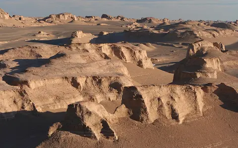
Western central Lut is corrugated by kaluts, the local name for elongated yardang ridges. A 2019 synthesis describes ridges of clay, silt, and sand with carbonate and evaporite material, separated by northwest–southeast wind corridors across a tract about 140 km long and 80 km wide.[3] Deflation removes loose fine particles; saltating sand abrades exposed faces; and occasional runoff, gullying, and mass movement widen corridors and trim ridge flanks.[2]
Published yardang heights are not directly consistent. The 2019 synthesis reports ridges commonly around 10 m and locally 50 m; a 2023 paleohydrological study reports relief up to 70 m over approximately 6,870 km²; UNESCO's property inventory gives some kaluts as high as 155 m and traceable for more than 40 km.[1][3][4] The sources do not document one shared height method, ridge sample, or local datum, so the larger value is retained as an inventory report rather than treated as a settled maximum.
East of the kaluts lies Rig-e Yalan, an erg, or connected sand sea. The 2019 study gives an approximate footprint of 50 × 100 km and reports sand rises up to 475 m; UNESCO independently reports dunes reaching 475 m within the protected property, but neither source specifies a vertical datum or survey method for that maximum.[1][3] Linear, compound crescentic, star, and funnel-shaped dunes occur alongside sand sheets. Between the erosional and depositional tracts are gravel plains, playas, and hamada—rocky desert surfaces from which much finer sediment has been removed.
Kalut yardangs
Older fine-grained basin deposits survive as streamlined ridges between wind-scoured corridors.
Playas and hamada
Salt-affected lows, gravel sheets, pediments, and hard rock surfaces separate the principal ridge and dune fields.
Rig-e Yalan
An active sand sea stores sediment in several dune forms rather than one uniform field of crescent dunes.
Lake sediment reworked by water and wind
The kaluts are erosional remnants of sediment laid down when a much larger lake occupied central Lut. A national-scale paleohydrological reconstruction calculated a former lake area of 16,226 km² and found a comparable outline in earlier work.[4] This is a modeled paleolake footprint, not a modern desert area. The sediment includes fine lake and basin material with evaporites and carbonates, which helps explain why both wind corridors and salt landforms occur in the same terrain.[3]
The sequence is clearer than its calendar age. Lake mud accumulated in the depression; falling base level exposed it; wind and episodic runoff dissected the surface into ridges and corridors; and mobile sand was transferred into downwind sheets and dunes. Published interpretations place the former lake in the Pliocene or Early Pleistocene, but the 2023 review says the yardangs' geochronology remains undetermined.[4] Later wetter phases left smaller saline playas among the ridges rather than restoring one basin-wide lake.
Runoff ends in a saline interior
The Lut is endorheic: surface water flows toward internal lows and is lost mainly through infiltration and evaporation, with no outlet to the ocean. The principal northern inflow is the Rud-e Shur. IUCN describes it as perennial but already highly saline where it enters the protected core; its channel is lined with salt crystals and it terminates toward the central depression. From the south, the Fahraj catchment supplies intermittent flow.[2]
Most other channels respond briefly to rain or snowmelt in the surrounding uplands. Flows spread across alluvial fans, cut gullies in fine sediment, and wash sand toward the basin floor. As water evaporates, dissolved minerals remain as efflorescent crystals, polygonal playa crusts, gypsum forms, and salt-coated channels.[1] The 117 m salt plain reported by IUCN is therefore both a topographic low and a sediment-and-solute sink, not a permanent lake.[2]
Rain shadow, seasonal pressure gradient, extreme surfaces
UNESCO classifies the setting as an arid continental subtropical region whose mountain enclosure intensifies the rain shadow.[1] A peer-reviewed field synthesis reports annual precipitation below 50 mm for the Lut region and a de Martonne aridity index below 1 for central Lut, compared with 2–4 on the margins. It also assigns central Lut to the “Tropical Hyperdesertic” class in the Global Bioclimatic Classification System.[3] These are regional and classification values, not a modern weather-station normal for every point in the basin.
In spring and summer, a north–south pressure gradient produces strong north-northwesterly to south-southeasterly winds, especially from June through October.[1][2] The regional direction explains the alignment of the kalut corridors, but local dune motion is more complicated. A study of 391 barchans measured migration from 1.1 to 15.35 m per year, averaging 5.17 m per year; movement was northwest-to-southeast in the western sample and southwest-to-northeast in the eastern sample.[6] Those rates apply to the sampled barchans, not all Lut dunes.
Heat records also require a measurement label. Aqua MODIS Collection 6, sampled on a 1 km grid, returned a maximum land-surface temperature of 80.83 °C in the Lut in 2018; the authors attribute the increase over the earlier 70.7 °C figure largely to the improved retrieval and finer product resolution.[5] This is radiometric skin temperature of the ground, not the standard shaded air temperature used in meteorological records. A separate logger placed 20–30 cm above ground at 29°57.5′N, 59°4.3′E and 285 m elevation recorded about 0–61 °C between April 2014 and February 2016, with a 2015 mean of 31.6 °C; its nonstandard height likewise prevents direct comparison with a conventional two-metre weather station.[3]
Iran's contrasting interior deserts
Within the Desert Hub, the Lut is best read as a mountain-enclosed erosion-and-deposition system. To the northwest, Dasht-e Kavir is another Iranian Plateau interior desert, but its geography is more strongly organized around kavirs and connected salt-basin terrain. The comparison does not imply that the two deserts share one drainage basin.
The Taklamakan Desert offers a second process comparison: both occupy sediment-receiving Asian interior basins, yet the Lut's exposed paleolake deposits, kalut tract, saline terminal low, and sharp transition into Rig-e Yalan form a distinct arrangement.
Sources and measurement notes
- UNESCO World Heritage Centre, “Lut Desert”, World Heritage List property 1505 (inscribed 2016; accessed 29 August 2026). Source for the accepted name, reference coordinate, 2,278,015 ha property and 1,794,134 ha buffer, basin setting, landform shares and reported dimensions, wind season, and evaporite forms. Area conversions use 100 ha = 1 km².
- International Union for Conservation of Nature, IUCN Evaluations of Nominations of Natural and Mixed Properties to the World Heritage List, WHC/16/40.COM/INF.8B2, pp. 16–23 (May 2016). Source for the three-province extent of the nominated property, 10–30 km buffer width, 117 m terminal salt-plain elevation, Rud-e Shur and Fahraj drainage, and the role of wind, runoff, and mass movement. The report does not state a vertical datum for 117 m.
- Pourkhorsandi, H. et al., “Meteorites from the Lut Desert (Iran)”, Meteoritics & Planetary Science 54(8), 1737–1763 (2019). Source for regional geology, the northern–central–southern division, 140 × 80 km kalut and approximately 50 × 100 km Rig-e Yalan tracts, reported landform heights, precipitation and aridity classifications, and the 2014–2016 near-ground logger record.
- Shoaee, M. J. et al., “Defining paleoclimatic routes and opportunities for hominin dispersals across Iran”, PLOS ONE 18(3), e0281872 (2023). Source for the modeled 16,226 km² Lut paleolake, approximately 6,870 km² yardang distribution, up-to-70-m ridge relief, lacustrine interpretation, age uncertainty, later saline playas, and the separate Jazmurian basin.
- Azarderakhsh, M., Prakash, S., Zhao, Y. & AghaKouchak, A., “Satellite-Based Analysis of Extreme Land Surface Temperatures and Diurnal Variability Across the Hottest Place on Earth”, IEEE Geoscience and Remote Sensing Letters 17(12), 2025–2029 (2020), doi:10.1109/LGRS.2019.2962055. NASA's publication record identifies Aqua MODIS Collection 6, 1 km resolution, and the 80.83 °C 2018 land-surface value; this is not a conventional air-temperature observation.
- Salehipour Milani, A., Barkhordari, N., Shabani, S. & Mohammadi, A., “Geomorphology and wind regime of barchans in the Lut Desert (Iran)”, Zeitschrift für Geomorphologie 62(4), 265–290 (2021). Source for the 391-dune sample, measured migration range and mean, and differing western and eastern movement directions.