Where this record begins and ends
Yablonovy Range transliterates Russian Yablonovy khrebet more closely; Yablonoi Mountains is an established English form and the name used in this atlas. This record follows the modern regional definition, not older usage that treated “Yablonoi” as part of a much larger east-Siberian mountain chain or as the separate Khentii highlands of Mongolia. (Brockhaus and Efron historical entry; Kulakov and Krivenko, 2009)
Under that definition, the range begins on the left bank of the Khilok near the Ungo confluence. It first runs broadly eastward, then turns northeast on the left side of the Ingoda basin and continues toward the confluence of the Vitim and its right-bank tributary the Karenga. The regional encyclopedia rounds this span to 700 km. Hrvatska enciklopedija instead gives about 650 km. Neither source publishes endpoints as a surveyed polygon, so the figures should not be combined into a false-precision measurement. (Encyclopedia of Transbaikalia; Croatian Encyclopedia)
Three river systems, two oceans
Runoff from the western side enters the Khilok, then the Selenga and Lake Baikal; the Angara carries it onward to the Yenisei and Arctic Ocean. Northern headwaters enter the Karenga–Vitim network and reach the Lena, a separate Arctic-draining system. Southeast-facing streams enter the Ingoda and Chita, then the Shilka and Amur on their route to the Pacific. The range is therefore a basin boundary, not the common source of three trunk rivers. (Great Russian Encyclopedia; Encyclopedia of Transbaikalia)
Near Chita, Mount Pallas is the conventionally mapped junction of the Yenisei, Lena, and Amur catchments. Russian Government Resolution no. 903 (10 September 2012) fixed the summit name, coordinates at 52°07.3′ N, 113°01.7′ E, and absolute height at 1,236 m; it did not state a horizontal or vertical datum. (Russian Geographical Society, 2012, pp. 15 and 177)
The “point” needs a hydrological qualification. A 2024 review from the V. B. Sochava Institute of Geography confirms Mount Pallas as the principal three-basin junction under the ordinary mapped drainage arrangement and notes that the State Water Register assigns Lake Arahley to the Yenisei basin. During rare high-water conditions, however, Arahley can spill toward Lake Ivan in the Lena basin. That temporary lake bifurcation can turn the Lena–Yenisei boundary into a shifting divide area, so Mount Pallas should not be described as a permanently exact place where any three drops must separate. (Kalikhman, 2024, pp. 68–70)
Broad crests, narrow crossings, and river-cut slopes
The Yablonovy is one of the southwest–northeast-trending ranges of central Transbaikalia. Near the Chita headwaters a low link called the Chingikan connection joins it to the roughly parallel Chersky Range. Other connections near the upper Ungo and Lake Arey lead toward the Malkhan Range. The city of Chita lies southeast of the central range rather than inside a single continuous mountain wall. (Kulakov and Krivenko, 2009)
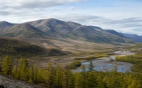
Width changes from just over 20 km north of Chita to more than 80 km in the upper Karenga area. Most crest elevations are reported at 1,200–1,400 m. Slopes are generally less abrupt than in alpine ranges but steepen beside incised rivers and along weakened fault zones; rocky outcrops, kurums (coarse frost-shattered block fields), and remnants of broad erosion surfaces occupy the upper terrain. These figures describe a variable belt, not a uniform ridge profile. (Encyclopedia of Transbaikalia)
The regional source identifies Kontalaksky Golets at 1,706 m as the high point. A separate modern encyclopedia gives a maximum of 1,678 m; neither reference states a vertical datum or measurement method. This page retains the local regional value and labels the disagreement rather than treating one number as a newly surveyed elevation. Golets is a regional term for a bare or sparsely wooded summit above the main forest belt. (Encyclopedia of Transbaikalia; Croatian Encyclopedia)
Old crust, younger intrusions, renewed relief
The rocks exposed in the range are not all the same age, and they are older than much of the present topography. Regional mapping places the Yablonovy in the Khilok–Vitim structural zone. Its framework includes Proterozoic and early Paleozoic gneissic granitoids arranged in elongated domes, with remnants of older metamorphic rocks and later Permian–Triassic volcanic rocks and Triassic alkaline syenites. A synthesis of the wider Baikal–Vitim fold system likewise describes the Malkhan–Yablonovy crustal block as an arch containing early Precambrian blocks, Riphean metamorphic units, Vendian–Cambrian cover, and Paleozoic intrusions. (Encyclopedia of Transbaikalia; Ruzhentsev and others, 2012)
In the southwest, the range's alignment follows the deep Mongol–Okhotsk fault system; the northeastern sector follows the Onon–Turin fault system. The regional interpretation places the beginning of range development in the Middle Jurassic, inferred partly from the lack of older sedimentary fill in neighboring Chita–Ingoda depressions. Later uplift, river incision, erosion, and frost weathering produced the modern mixture of broad summit surfaces, steeper valley flanks, tors, and block fields. “Middle Jurassic” therefore marks a proposed start of relief development, not the age of every rock in the range. (Kulakov and Krivenko, 2009)
Crystalline domes
Gneissic granitoids and older metamorphic remnants form much of the structural framework.
Several magmatic episodes
Paleozoic intrusions and Permian–Triassic volcanic and alkaline rocks record later events.
Fault-guided erosion
Inherited structures help align the range and the valleys that dissect it.
Summer rain, winter low flow, and frost-shaped slopes
The range spans several degrees of latitude and elevation, so one Chita station or one regional average would not represent it. The dependable regional pattern is strongly continental: prolonged anticyclonic winter weather is cold and dry, spring is dry, and precipitation reaches its annual maximum in July–August. Published Transbaikal totals range from about 300 mm a year in intermontane basins to 800 mm on slopes of the much higher Stanovoy uplands; these are regional brackets, not measurements of the Yablonovy Range itself. (Great Russian Encyclopedia)
Rain supplies most river flow across Transbaikalia. A long winter low-flow season follows; smaller channels may freeze to the bed, and sheet-like river ice called naleds forms where water repeatedly freezes in valleys. Summer and autumn rain floods commonly carry more water than spring snowmelt. Widespread permafrost, seasonal freezing, and differences between sun-facing and shaded slopes help loosen rock and feed the kurums, while streams remove the resulting sediment from steeper valley sides. (Great Russian Encyclopedia)
The principal elevation sequence is mountain taiga, open woodland below the bare summits, and golets terrain with stone fields and dwarf scrub. Dark-conifer stands occur on parts of the Yablonovy and neighboring Malkhan ranges, but the belt boundaries vary with latitude, aspect, and local exposure; a single fixed “tree line” for all 650–700 km would be misleading. (Encyclopedia of Transbaikalia; Great Russian Encyclopedia)
Data sources and publications
- Kulakov, V. S., and Krivenko, V. A. “Yablonovy Range.” Encyclopedia of Transbaikalia, electronic edition; based on Small Encyclopedia of Transbaikalia: Natural Heritage, Novosibirsk: Nauka, 2009 (accessed 30 August 2026). Modern regional scope, endpoints, 700 km length, width, crest elevations, 1,706 m high point, structural zones, rock units, relief, and landscape belts.
- Samoilova, G. S., Khoroshev, A. V., Materikova, T. V., and contributors. “Transbaikalia.” Great Russian Encyclopedia, electronic edition (accessed 30 August 2026). Regional physiography, Malkhan–Yablonovy crustal setting, climate, permafrost, runoff seasonality, drainage networks, and elevation belts. Climate figures are used as regional context, not range-wide observations.
- Ruzhentsev, S. V., Minina, O. R., Nekrasov, G. E., Aristov, V. A., Golionko, B. G., Doronina, N. A., and Lykhin, D. A. “The Baikal–Vitim Fold System: Structure and Geodynamic Evolution.” Geotectonics 46(2) (2012), 87–110. Regional tectonic synthesis of the Malkhan–Yablonovy crustal block, Khilok–Vitim zone, basement rocks, cover units, and intrusive history.
- Government of the Russian Federation. Resolution no. 903, 10 September 2012, reproduced in Proceedings of the Transbaikal Branch of the Russian Geographical Society, issue 131 (2012), pp. 15 and 177. Official Mount Pallas name, 52°07.3′ N, 113°01.7′ E coordinates, and 1,236 m absolute height; the resolution supplies no stated datums.
- Kalikhman, T. P. “On the Question of Watershed Points on the Yablonovy Range.” Proceedings of the Transbaikal Branch of the Russian Geographical Society, issue 138 (2024), 68–70. Institute of Geography review of Mount Pallas, the State Water Register assignment of Lake Arahley, episodic spill toward Lake Ivan, and the resulting qualification of a fixed triple-divide point.
- Leksikografski zavod Miroslav Krleža. “Jablonovsko gorje.” Hrvatska enciklopedija, online edition, 2013–2026 (accessed 30 August 2026). Independent 650 km length and 1,678 m maximum-elevation figures, retained to document disagreement among reference works.
- Weinberg, L. “Stanovoy Range (also Yablonovy).” Brockhaus and Efron Encyclopedic Dictionary, historical edition (accessed through the Vologda Regional Universal Scientific Library, 30 August 2026). Used only to document the obsolete broad usage that joined Yablonovy, Stanovoy, and Khentii into one extensive mountain system; its measurements are not used.