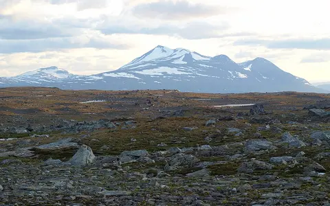

A physical range with gradual ends
Scandinavian Mountains and Scandes name the topographic mountain system. Norwegian Skandene, Swedish Skanderna or Kölen, and Finnish Skandit are language variants, not separate ranges. This record covers the whole physical highland, not the Scandinavian Peninsula, the wider Fennoscandian Shield, the Scandinavian Caledonides as a mapped rock belt, or any national park or administrative region. Jotunheimen, Hardangervidda, Dovrefjell, Sarek, the Kebnekaise massif, and the Lyngen Alps are named parts or terrain units within the wider system. (Store norske leksikon; Finto YSO Places)
SMHI describes the range as about 1,700 km long and up to 300 km wide. A Norwegian geographic reference gives a length of nearly 1,300 km, extending from the southern Norwegian uplands through western Sweden to Finnmark and the mountains around northernmost Finland. Neither description supplies surveyed end lines, and the outer uplands merge gradually with neighboring terrain; the figures should therefore be read as different generalized scopes, not combined into a more precise average. The separate geological Caledonide belt has still broader mapped dimensions. (SMHI range description; Store norske leksikon)
For catalogue orientation, Finto records 65° N, 14° E for the feature. That is a representative label point in central Scandinavia, not a centroid, summit, boundary coordinate, or claim about the range's limits; the catalogue does not state a geodetic datum for the point. An elongated feature is better located by its named regional relationships than by one coordinate.
High southern and northern massifs linked by lower uplands
The highest sector lies in southern Norway. Galdhøpiggen reaches 2,469 m above sea level between Visdalen and Leirdalen in the Jotunheimen massif. The value is a rounded summit elevation, not local relief above either valley. Jotunheimen also contains many of the range's other highest rock summits; plateau country at Hardangervidda lies farther southwest, while Dovrefjell forms a major central-southern upland. (Store norske leksikon: Galdhøpiggen)
North of central Norway, relief rises again through coastal Nordland and Troms and the border mountains of Swedish Lapland. Alpine groups such as Lyngen, Kebnekaise, and Sarek alternate with lower passes and gentler fells. The international border often follows or approaches high ground, but it is an administrative line, not the definition of the range: mountains also lie west of it across Norway and east of it in Sweden, and the outer northeastern terrain reaches Finland.
The cross-range profile is strongly asymmetric. In western Norway, high ground is close to the North Sea and Norwegian Sea, so valleys descend rapidly toward fjords and coastal lowlands. Eastward, the mountains generally step down more gradually across Swedish fells, headwater lakes, forested valleys, and the low-relief Fennoscandian interior. Broad summit surfaces can therefore stand close to deep troughs and fjords, producing large local relief even where the plateau itself is gently rolling. (Store norske leksikon)
Short, deeply cut routes to sea
Fjords, hanging valleys, cirques, and steep rock walls concentrate relief along much of coastal Norway.
Plateaus and separate massifs
Hardangervidda, Jotunheimen, Dovrefjell, Sarek, and Kebnekaise show that the Scandes are a system of distinct uplands.
Longer descent across Sweden
Fell valleys and headwater lakes connect the divide to long rivers crossing the interior toward the Baltic or Kattegat.
Caledonian structures over older continental crust
Much of the range follows the Scandinavian Caledonides, the eroded remains of a Paleozoic collisional mountain belt. The Geological Survey of Sweden places the Caledonian orogeny broadly at 510–400 million years ago. A geophysical synthesis narrows the final Baltica–Laurentia continent collision to about 425–400 million years ago, after closure of the Iapetus Ocean. (SGU; Korja and others, 2008)
Collision shortened the western edge of Baltica and pushed stacked sheets of rock eastward over its Precambrian basement. These transported sheets are called nappes. They include metamorphosed continental-margin sediments, volcanic and oceanic material, and slices of much older basement; resistant gabbro in the Jotun nappe helps support the high Jotunheimen massifs. The geology is consequently not one uniform “ancient rock” unit.
The geological belt and the modern mountain range overlap but are not interchangeable. Korja and colleagues describe exposed Scandinavian Caledonian structures in a belt about 1,800 km long and up to 400 km wide. Those dimensions map a thrust-and-fold belt, whereas SMHI's 1,700 × up-to-300 km figure describes a topographic range. Bedrock age also does not date the present relief: the original Caledonian mountains were deeply eroded long before today's plateaus, valleys, and fjords developed.
Ancient structure, disputed uplift, repeated erosion
Why high topography persists along a passive continental margin is still debated. One family of interpretations invokes episodes of Cenozoic uplift that raised old low-relief surfaces; another emphasizes prolonged exhumation, climate-driven erosion, and isostatic response after rock was removed. A major review explicitly treats the issue as a contest between Neogene uplift models and an isostasy–climate–erosion hypothesis. The range should therefore not be assigned one uplift date or one accepted mechanism. (Nielsen and others, 2009)
What is not disputed is that river incision, frost weathering, slope failure, mountain glaciers, and continental ice sheets acted on the inherited rock structure over long intervals. Rock type and fractures guided erosion, while erosion changed relief and unloaded the crust. The modern landscape is thus younger than the Caledonian deformation even though much of its structural grain comes from Caledonian nappes and older basement.
Fjords and plateaus record unequal ice erosion
Repeated late Pliocene and Quaternary glaciations enlarged existing valleys into U-shaped troughs, excavated rock basins now occupied by lakes, cut cirques into massif margins, and overdeepened western valleys below present sea level. After deglaciation and marine flooding, the deepest coastal troughs became fjords. Ice did not simply plane the whole range to one form: fast, thick outlet ice concentrated erosion in major valleys, while summit surfaces experienced different mixtures of erosion, weathering, and preservation.
A western-Scandinavia sediment-budget study examined the interval from the present to 2.8 million years ago. Its model found that fjord excavation could account for only 35–55% of the sediment deposited off Norway, implying substantial glacial and periglacial erosion away from fjords, including at high elevation. That percentage is a regional source-to-sink model result, not the fraction of every valley cut by ice. (Steer and others, 2012)
This selective erosion explains the range's close juxtaposition of subdued and alpine terrain. Hardangervidda preserves wide, low-relief uplands; Jotunheimen and Sarek contain sharper ridges and cirques; western Norway has deep troughs and fjords; and the Swedish flank contains glacially scoured lake basins along a gentler regional descent. Moraines, till, outwash, and exposed bedrock mark where ice deposited, transported, or removed material during successive glaciations.
A divide with Atlantic, Baltic, and Kattegat routes
Much of the highland divides water flowing west and northwest to the North Sea, Norwegian Sea, and Barents Sea from water flowing east toward the Gulf of Bothnia and the wider Baltic basin. On the Norwegian flank, high relief and a nearby coast produce many short, steep rivers entering fjords. On the Swedish flank, headwaters join longer systems such as Dalälven, Indalsälven, Umeälven, and Luleälven. NVE's national ELVIS river network records flow direction, while its REGINE system defines Norwegian catchments from 1:50,000 mapping; national borders are data boundaries, not natural watershed boundaries. (NVE watercourse data; SMHI river records)
The simple phrase “Atlantic–Baltic divide” needs qualification in the south. The headwaters of the Klarälven–Göta älv system begin around Rogen in the Norway–Sweden border uplands, pass through Norway as the Trysilelva, return to Sweden, and ultimately leave Vänern for Kattegat rather than the Baltic. SMHI gives the complete source-to-sea system a length of 746 km; this is a river-route measurement, not the width of the mountains.
Local divides can be narrow and geomorphically revealing. Lesjaskogsvatnet lies on the watershed between northwestern and eastern Norway and drains both west through the Rauma to Romsdalsfjorden and southeast through Gudbrandsdalslågen. NVE interprets tributary geometry in the Rauma basin as evidence that glacial erosion shifted parts of the divide eastward. The example shows that a drainage divide can migrate over geological time rather than remain fixed to the highest modern crest. (NVE: Rauma basin)
Snow storage sets the inland flow rhythm
Winter precipitation accumulates as snow over high and northern terrain, delaying runoff until thaw. In the Swedish rivers from Dalälven north to Torneälven, SMHI defines the start of spring flood as the first day after winter low flow when discharge rises above the long-term mean. Across 22 unregulated river records, the start has advanced by roughly 5–15 days since the early twentieth century, although year-to-year variation remains large. (SMHI spring-flood indicator)
The seasonal pattern is not uniform across the full 1,700-km range. Maritime western catchments can receive substantial rain in winter and respond rapidly to storms, while colder inland and northern catchments store a larger share of winter precipitation as snow. Glaciers delay a smaller additional component of runoff into summer in glacierized basins. Lakes, wetlands, valley aquifers, and engineered reservoirs further alter the timing between headwater melt and downstream flow.
Westerly moisture, relief, latitude, and elevation
North Atlantic low-pressure systems commonly approach from the west or southwest. Air forced upward over the Norwegian flank cools, condenses, and produces orographic rain and snow; descending air east of the crest warms and dries, creating a pronounced rain shadow. Latitude, elevation, distance from open water, slope aspect, and local valley shelter modify that first-order west–east pattern.
Norway's Meteorological Institute used the 1-km KlimGrid dataset for the 1991–2020 standard normal and estimated annual precipitation ranging from 212 mm at Saltdal, a sheltered Nordland interior valley, to 6,130 mm at Ålfotbreen in the wet western mountains. These are gridded point extremes within Norway, not measured averages for the Scandes or for each flank. On the Swedish side, SMHI estimates locally 1,500–2,000 mm per year near the Norwegian border but cautions that few official stations occupy the highest terrain. (MET Norway Report 1/2024; SMHI: Sweden's climate)
Temperature generally decreases with elevation and northward latitude, but proximity to the ocean moderates winter cold along western and northern coasts. The same elevation can therefore support different snow duration, permafrost conditions, and glacier balance in maritime western and continental eastern settings. Exposed plateaus also experience stronger wind redistribution of snow than sheltered valleys, so one weather station or one “snowline” cannot characterize the entire range.
A national inventory, not a range-wide total
Modern glaciers remain concentrated in western and northern Norway and in high massifs on both sides of the northern border. Jostedalsbreen, Hardangerjøkulen, Folgefonna, Svartisen, and the Jotunheimen glaciers are prominent Norwegian examples; smaller glacier groups occur around Kebnekaise and Sarek in Sweden. These are remnants of present climate conditions, not surviving pieces of the former continental ice sheet.
The latest complete Norwegian inventory mapped 2,328 ± 70 km² of glacier and perennial ice in 2018–2019. It used 10-m Sentinel-2 imagery, a semi-automated band-ratio method, manual editing, and validation against orthophotos and higher-resolution satellite images. The stated uncertainty is about 3% for the national total, with larger relative errors for the smallest ice bodies. The figure covers mainland Norway—not the whole Scandinavian Mountains—and the authors explicitly note that their northern Scandinavian subregion omits Swedish glacier area. (Andreassen and others, 2022)
For glacier units mapped in both inventories, area decreased by 15.3% between the 1999–2006 Landsat inventory and 2018–2019. The study reports a 22% reduction in northern Norway and 10% in southern Norway, but northern baseline images were generally older, so those percentages do not represent identical time spans. Newly detected small ice bodies also make a simple subtraction of national totals method-dependent. Glacier area must therefore retain its image dates, boundary rules, and geographic scope.
From fjord heads to inland river plains
The Scandes connect several physical systems without sharing their boundaries. Their western valleys continue below sea level into fjords and the Norwegian shelf; their eastern rivers cross the Caledonian front onto older shield terrain; their northern uplands merge with Finnmark, Swedish Lapland, and the outer mountains of northern Finland. The range is consequently both a barrier and a source region, but not a single crest coincident everywhere with a national border or one continental divide.
Use the Mountain Hub to compare mountain systems, the Alps for a younger European collisional range with strong glacial relief, or the Ural Mountains for another long, old continental mountain system. The comparison is geomorphic; it does not imply equivalent ages, tectonic settings, or boundary definitions.
Data sources and publications
- Swedish Meteorological and Hydrological Institute (SMHI). Scandinavian Mountains, updated 2 February 2026, accessed 30 August 2026. Topographic range length, maximum width, position, and principal climate controls.
- Askheim, S., and Lundbo, S. Den skandinaviske fjellkjeden. Store norske leksikon, updated 15 May 2026, accessed 30 August 2026. Norwegian and international names, alternate range extent, national scope, relief pattern, and regional units.
- National Library of Finland. Scandinavian Mountains, YSO Places, record edited 25 September 2024, accessed 30 August 2026. Preferred name, Finnish and Swedish variants, countries, and representative catalogue coordinate.
- Mæhlum, L., and Lauritzen, P. R. Galdhøpiggen. Store norske leksikon, updated 26 May 2026, accessed 30 August 2026. Summit elevation, position within Jotunheimen, and rock-summit context.
- Geological Survey of Sweden (SGU). The bedrock of Sweden, reviewed 22 September 2020, accessed 30 August 2026. Caledonian age range and relationship to Precambrian shield rocks.
- Korja, T., Smirnov, M., Pedersen, L. B., and Gharibi, M. Structure of the Central Scandinavian Caledonides and the underlying Precambrian basement, new constraints from magnetotellurics. Geophysical Journal International 175 (2008), 55–69. Caledonide dimensions, Iapetus closure, Baltica–Laurentia collision, and nappe architecture.
- Nielsen, S. B., and others. The evolution of western Scandinavian topography: A review of Neogene uplift versus the ICE (isostasy–climate–erosion) hypothesis. Journal of Geodynamics 47 (2009), 72–95. Competing interpretations of high topography, erosion surfaces, exhumation, and uplift.
- Steer, P., Huismans, R. S., Valla, P. G., Gac, S., and Herman, F. Bimodal Plio–Quaternary glacial erosion of fjords and low-relief surfaces in Scandinavia. Nature Geoscience 5 (2012), 635–639. Study period, fjord-sediment budget, and evidence for erosion beyond major troughs.
- Andreassen, L. M., Nagy, T., Kjøllmoen, B., and Leigh, J. R. An inventory of Norway's glaciers and ice-marginal lakes from 2018–19 Sentinel-2 data. Journal of Glaciology 68 (2022), 1085–1106. Image dates, 10-m method, mapped Norwegian glacier area and uncertainty, comparison rules, and change estimates.
- Lutz, J., Hanssen-Bauer, I., Tveito, O. E., and Dobler, A. Precipitation variability in Norway 1961–2020. Norwegian Meteorological Institute, MET Report 1/2024. KlimGrid normal period, national precipitation range, and west-southwest moisture setting.
- SMHI. Sveriges klimat, accessed 30 August 2026. Swedish 1991–2020 mountain precipitation and station-coverage caveat.
- Norwegian Water Resources and Energy Directorate (NVE). Vassdragsdata, accessed 30 August 2026. ELVIS flow-direction network, REGINE catchment system, source scale, and national data scope.
- SMHI. Sveriges största vattendrag, accessed 30 August 2026. Swedish river lengths, drainage areas, and the transboundary Klarälven–Göta älv route.
- NVE. 103/3 Rauma, accessed 30 August 2026. Lesjaskogsvatnet divide, Rauma outlet, and evidence for eastward divide migration.
- SMHI. Spring flood, updated 14 February 2025, accessed 30 August 2026. Indicator definition, 22-river station set, observed timing change, and limitations.