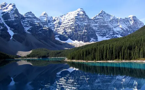

Named range, physiographic system, and cordillera
Rocky Mountains is the accepted English name in the Canadian record; Montagnes Rocheuses is its official French counterpart. That record places the range northwestward from New Mexico to northern British Columbia and gives about 3,000 mi (4,800 km) from New Mexico to the Liard River. Its coordinate, 54°29′59″ N, 122°29′59″ W (WGS 84), is explicitly the approximate centre of the feature in British Columbia. It is not a centroid for the complete transboundary range and does not define its boundary. (BC Geographical Names)
Scope changes explain apparently contradictory dimensions. A 1987 USGS synthesis treated the broader Rocky Mountain region as a belt of more than 100 ranges extending slightly over 5,000 km to the Bering Sea; it also included broad lowlands and northern mountain continuations beyond the Liard. That regional belt is not the same object as the conventionally named Rocky Mountains used here. The North American Cordillera is wider still: it also includes the intermontane plateaus and Pacific mountain system, so the Cascade Range, Coast Mountains, Sierra Nevada, and intervening plateaus are not subranges of the Rockies. (Madole and others, 1987)
From the Liard to New Mexico, with different regional divisions
The named chain begins near the Liard Plateau and Liard River in northern British Columbia, trends southeast along the British Columbia–Alberta mountain belt, crosses the international boundary into Montana, and continues through Idaho and Wyoming to the high ranges of Colorado and north-central New Mexico. The B.C. record measures its provincial part at about 1,200 km (750 mi) from the Montana boundary to the Liard Plateau. South of Canada there is no single uninterrupted crest: the ranges spread around basins and volcanic plateaus in Montana, Idaho, and Wyoming, then regroup into high north–south ranges in Colorado and the Sangre de Cristo Mountains of New Mexico. (BC Geographical Names; NPS Rocky Mountain System Provinces)
The physical margins are asymmetric. The eastern mountain front commonly rises abruptly above the Rocky Mountain Foothills and Great Plains. Westward the boundary is less uniform: the Rocky Mountain Trench separates much of the Canadian Rockies from mountains and plateaus of interior British Columbia, while high basins and plateaus adjoin the U.S. ranges. The USGS regional synthesis reported widths from less than 100 km in the Canadian Rockies to nearly 600 km in the Middle Rockies of Wyoming and northeastern Utah. Those are widths of its defined physiographic region, not a surveyed polygon for the named chain. (Madole and others, 1987)
Parallel sedimentary ranges
Main and Front ranges trend northwest–southeast, with the highest western crest beside the Rocky Mountain Trench.
Ranges around high basins
The Absaroka, Wind River, Bighorn, Teton, and Uinta ranges are separated by broad structural and volcanic lowlands.
High basement-cored uplifts
The Front, Sawatch, Park, Gore, San Juan, and Sangre de Cristo ranges frame elevated parks and rift basins.
Mount Elbert is the high point; one coordinate cannot locate the range
Mount Elbert in Colorado's Sawatch Range is the highest summit in the Rockies. The U.S. Board on Geographic Names lists the official summit at 39.1178687° N, 106.4452569° W; GNIS coordinates use NAD 83. The point locates Mount Elbert, not the centre of the Rocky Mountains. USGS guidance is especially important here because GNIS records coordinates for ranges, ridges, and summits at their highest point rather than at a geometric centre. (U.S. Board on Geographic Names, Review List 453; USGS GNIS guidance)
Published elevations differ because the vertical reference and survey method changed. The GNIS/topographic feature record retains 14,433 ft, the elevation on the 1967 USGS Mount Elbert quadrangle. NOAA's National Geodetic Survey later combined summit GNSS observations with a geoid model and obtained a preliminary 4,400.58 ± 0.064 m (14,437.6 ft) orthometric height on the proposed NAPGD2022 realization. NOAA explicitly marks that value preliminary because the datum has not yet been officially defined. This page therefore rounds the atlas headline to about 4,400 m rather than converting or merging the incompatible figures. (USGS summit elevations; NOAA National Geodetic Survey)
Range-scale relief is as important as summit elevation. The USGS synthesis found summits commonly 1,500–2,100 m above adjacent lowlands, while absolute summit elevations across its region ranged roughly from 1,800 to 4,400 m. Broad parks, trenches, and basins are integral to this relief: they divide the mountain groups, collect sediment, and provide low-gradient reaches between steep headwater valleys. (Madole and others, 1987)
One topographic chain built from different structures
The Rockies are not the product of one rock type or a single uniform uplift. In the Canadian Rockies, Paleozoic and Mesozoic sedimentary rocks that accumulated on the western margin of ancient North America were shortened into folds and stacked along west-dipping thrust faults. These overlapping sheets moved generally eastward, thickening the crust and depressing a foreland basin along the plains. The Main and Front ranges expose resistant limestone, dolomite, quartzite, and sandstone as long, parallel ridges; weaker shale units are preferentially eroded into valleys. (Alberta Geological Survey; Parks Canada, Jasper geology)
In much of the middle and southern U.S. Rockies, the defining Late Cretaceous–early Cenozoic event was the Laramide orogeny—mountain building that raised deep blocks of Precambrian crystalline basement and folded their sedimentary cover far inland from the continental margin. NPS places the main southern Rocky Mountain uplift at approximately 70–40 million years ago and identifies shallow-angle subduction of the Farallon plate as the leading explanation for deformation so far from the plate edge. Anticlinal arches, reverse faults, adjacent subsiding basins, volcanic fields, and later normal faults produced sharply different range forms. (NPS Rocky Mountain System Provinces; NPS, Mountains Old and New)
Later processes modified the Laramide framework. Volcanism built the Absaroka Plateau and San Juan volcanic terrain; faulting raised the Teton front; and extension formed the Rio Grande Rift along the southern end of the system roughly 25–3 million years ago. Rivers then removed rock from the uplifts and deposited gravel, sand, and mud in adjoining basins. “The Rockies formed 70–40 million years ago” is therefore a useful description of a major episode, not the age of every rock, range, or present landform. (NPS)
Glaciers sharpened northern and high-elevation terrain
Repeated Pleistocene glaciations excavated cirques at valley heads, widened river-cut valleys into U-shaped troughs, sharpened arêtes and horns, and left moraines and chains of rock-basin lakes. Glacial effects are strongest in the Canadian and northern U.S. Rockies and in the highest ranges of Wyoming and Colorado; lower or drier sectors retained more fluvial and weathered slopes. Frost cracking, rockfall, debris flows, avalanches, and streams continue to move sediment from cliffs to fans and basin floors. (NPS, Glacier National Park geology)
Modern ice is much smaller than the valley glaciers that created the major troughs, and counts depend on date and minimum area. A USGS inventory inside Glacier National Park found 80 ice bodies larger than 0.1 km² at the mid-19th-century Little Ice Age maximum and 32 above the same threshold in 2005. These are mapped park-boundary counts, not totals for the Rocky Mountains. USGS also maintains outlines for 1966, 1998, 2005, and 2015, illustrating why glacier area must always be attached to an observation year and mapping threshold. (USGS Northern Rocky Mountain Science Center)
A continental divide and a set of outward-flowing headwaters
Long sections of the Continental Divide follow Rocky Mountain crests, but the divide and the named range are not identical. West of the divide, the upper Fraser and tributaries of the Columbia and Colorado systems carry water toward the Pacific or Gulf of California. East and northeast, the Saskatchewan, Athabasca, Peace, Yellowstone, Missouri, Platte, Arkansas, and Rio Grande systems ultimately drain toward the Arctic Ocean, Hudson Bay, or Gulf of Mexico. In Canada, Environment and Climate Change Canada explicitly maps the Pacific watershed boundary along the Rockies; in the United States, the divide threads between separate ranges and across high plateaus and basins. (Environment and Climate Change Canada; BC Geographical Names)
Drainage does not simply run perpendicular to every ridge. The Fraser begins on the western slope and turns through the Rocky Mountain Trench; the Peace River cuts eastward across the northern ranges; the Yellowstone flows from the Absaroka highlands toward the Missouri; and the Colorado and Rio Grande leave high snow-fed headwaters for semiarid plateaus and basins. At Jasper, for example, Parks Canada reports that the Athabasca flows nearly 150 km through the park from the Columbia Glacier and that combined snowmelt and rain produce peak flow beginning in late June, with glacier melt helping sustain July levels. This is a measured regional example, not a timing rule for all Rocky Mountain rivers. (Parks Canada, Jasper geology and drainage)
Latitude, height, exposure, and snow storage
The range crosses more than 20 degrees of latitude, so no single Rocky Mountain climate normal is meaningful. Temperature generally falls with height, while slope aspect changes solar exposure and snow persistence. Pacific moisture is partly depleted crossing the Coast Mountains and interior plateaus before it reaches the Rockies, yet air forced upslope still enhances precipitation on exposed western slopes. Descending air warms and dries toward many eastern foothills and plains; winter Chinook winds can produce rapid local warming and snow loss. A 2025 Journal of Climate study using observations and model experiments found that North American topography strongly enhances winter precipitation along western Rocky Mountain slopes while contributing to drying farther into the continental interior. (Johnson and Delworth, 2025)
Waterton Lakes National Park provides a compact measured transect: Parks Canada reports average annual precipitation of 152 cm at Cameron Lake on the Continental Divide, 107 cm at the townsite, and 76 cm at the park gate farther east. The agency page does not state a normal period or measurement method, so the figures describe its park-scale summary and should not be extrapolated to the whole range. Snow redistributed by wind accumulates in sheltered bowls, then delays runoff into spring and summer; warm rain on a deep melting snowpack can instead amplify floods. (Parks Canada, Waterton climate)
Snowpack is a variable water store, not a fixed characteristic. The U.S. Natural Resources Conservation Service reports snow water equivalent (the depth of liquid water contained in snow) against station-specific 1991–2020 medians and updates the reference period each decade. Consequently, a percentage of “normal” must identify the station, date, and normal period; a current basin percentage cannot stand as a permanent Rocky Mountains statistic. (USDA Natural Resources Conservation Service)
Data sources and publications
- BC Geographical Names Office. Rocky Mountains, official feature record (accessed 30 August 2026). Accepted English and French names, conventional limits and length, British Columbia extent, drainage summary, and approximate-centre coordinate with WGS 84 datum.
- Madole, R. F., Bradley, W. C., Loewenherz, D. S., Ritter, D. F., Rutter, N. W., and Thorn, C. E. Rocky Mountains. In Geomorphic Systems of North America, Geological Society of America, 1987, doi:10.1130/DNAG-CENT-v2.211. Broader regional definition, named-range count, width, relief, Mount Elbert, basins, and Rocky Mountain Trench.
- National Park Service. Rocky Mountain System Provinces (updated 1 May 2018; accessed 30 August 2026). U.S. Northern, Middle, Wyoming Basin, and Southern physiographic divisions and Laramide setting.
- U.S. Board on Geographic Names. Quarterly Review List 453, 2024, pp. 20–21; U.S. Geological Survey, What is the Geographic Names Information System (GNIS)? and Elevations of Named Summits Over 14,000 Feet Above Sea Level (accessed 30 August 2026). Mount Elbert official name, GNIS feature ID and coordinate, 1967 mapped elevation, coordinate convention, and NAD 83 datum.
- National Geodetic Survey. Moving Mountains (accessed 30 August 2026). GNSS/geoid method, preliminary NAPGD2022 Mount Elbert orthometric height, and stated one-sigma uncertainty.
- Alberta Geological Survey. Geological Atlas of the Western Canada Sedimentary Basin, Chapter 1: Introduction, 1994. Canadian Rocky Mountain thrust sheets, crustal thickening, erosion, and foreland-basin relation.
- National Park Service. Mountains, Old and New (updated 18 July 2018; accessed 30 August 2026). Southern Rockies Laramide timing, Ancestral Rockies distinction, and Rio Grande Rift overprint.
- Parks Canada. Geology—Jasper National Park (modified 17 November 2023; accessed 30 August 2026). Main and Front Range structure, Continental Divide, rock types, Athabasca route, and seasonal flow.
- National Park Service. Geologic Formations—Glacier National Park (accessed 30 August 2026); U.S. Geological Survey, Status of Glaciers in Glacier National Park (accessed 30 August 2026). Pleistocene landforms and dated, threshold-defined modern glacier inventories.
- Environment and Climate Change Canada. Pacific Ocean Watershed (modified 12 June 2019; accessed 30 August 2026). Canadian Continental Divide and Pacific drainage.
- Johnson, B. O., and Delworth, T. L. The Influence of North American Topography on Atmospheric Winter Circulation and Precipitation. Journal of Climate, vol. 38, no. 10, 2025, pp. 2283–2303, doi:10.1175/JCLI-D-24-0284.1. Orographic winter-precipitation controls.
- Parks Canada. Climate—Waterton Lakes National Park (modified 4 November 2025; accessed 30 August 2026). Local precipitation gradient, snow redistribution, Chinook mechanism, and rain-on-snow flooding.
- USDA Natural Resources Conservation Service. Climatic and Hydrologic Normals (accessed 30 August 2026). Snow-water-equivalent definition, 1991–2020 station normals, and comparison cautions.