.jpg)
Drakensberg, Maloti, and the Great Escarpment
Drakensberg is the conventional English name. uKhahlamba appears in the official name of the South African protected area, while Maloti (also written Maluti) is used for the connected Lesotho highlands and for the transboundary Maloti–Drakensberg region. These names overlap but are not interchangeable with Maloti-Drakensberg Park, a World Heritage property covering only selected protected land in South Africa and Lesotho.[2][3]
The scope here follows the mapped physical core used for the Drakensberg Mountain Centre: from Golden Gate Highlands National Park and the Oliviershoek Pass–Sterkfontein Dam area in the north, along the Lesotho–KwaZulu-Natal escarpment, to high ground north of Elliot in the Eastern Cape; its western side extends across the Lesotho Highlands toward the eastern lowlands. The boundary was drawn from mountain topography for a biogeographic study, so its 36,478 km² is a reproducible mapped area, not an official range area. Lower outliers and the separate Mpumalanga escarpment farther north are outside this page's measurement.[1]
A single latitude and longitude would misrepresent this elongated, boundary-dependent system. UNESCO publishes finding points of 29°22′59.99″S, 29°32′26.02″E for uKhahlamba Drakensberg Park and 29°54′55″S, 29°07′23″E for Sehlabathebe National Park. They locate the two World Heritage components; neither is a centroid or coordinate for the whole Drakensberg.[2]
A high rim with unequal sides
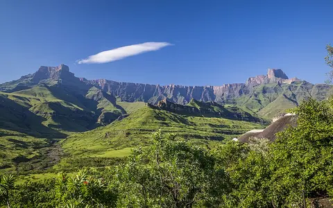
The crest is especially abrupt along the Lesotho–KwaZulu-Natal border. Eastward, headwater valleys cut into the escarpment and descend through the foothills toward the coastal margin. Westward, the ground remains high across the Lesotho plateau, but tributaries of the Senqu have dissected that interior into ridges and deep valleys. The escarpment is therefore a sharp topographic front on its seaward side and a drainage divide within broader high country on its landward side.[5]
The mapped Mountain Centre's lower boundary averages 1,716 m above sea level, with local limits from 1,318 to 2,076 m; those values describe the study boundary, not the foot and summit of every slope. Its highest published elevation is 3,482 m at Thabana Ntlenyana in eastern Lesotho. Lesotho's government baseline separately describes the adjoining high plateau as generally 2,700–3,200 m. The two measurements are compatible because one describes a broad plateau zone and the other a summit.[1][4]
Steep escarpment
Cutbacks and narrow valleys descend toward KwaZulu-Natal and the Indian Ocean drainage.
Basalt plateau
High rolling surfaces and rounded summits are remnants of a once wider volcanic cover.
Incised highlands
Senqu tributaries run through deep valleys across Lesotho rather than falling immediately from the rim.
Flood basalt above Karoo sedimentary rocks
Much of the core highland is built from the upper Karoo succession. Sandstone, siltstone, and shale were deposited first; the Clarens Formation near the top includes thick, largely wind-deposited sandstone. Around 183 ± 1 million years ago, repeated basalt lava flows buried that surface. Dolerite magma also solidified in fractures and between sedimentary layers as dykes and sills. The remaining Drakensberg basalt is about 1,000 m thick along the transect modelled by van der Beek and colleagues, who estimated that a further 500–1,000 m had been removed there. Those thicknesses are sector-specific geological reconstructions, not uniform values for the whole system.[5][6]
The dramatic two-tier appearance follows this layering. Resistant basalt holds much of the upper escarpment and summit plateau; Clarens sandstone forms pale or golden cliffs, caves, pillars, and broad lower ramparts where erosion has stripped back the basalt. Still older Karoo rocks appear farther downslope. Joints, faults, bedding surfaces, and differences in rock strength guide rockfall, weathering, valley position, and the stepped profiles of rivers.[3][5][6]
Breakup, incision, and slow scarp retreat
Opening of the southeast African continental margin lowered river base levels on the seaward side and allowed east-flowing rivers to cut into the elevated interior. The present escarpment is not simply the edge of an intact Jurassic lava sheet, nor did it retreat inland at one constant rate from the modern coast. Thermochronology and landscape modelling instead support a drainage divide near the present highland edge, followed by strong seaward denudation, river incision, and lithologically controlled retreat.[5]
Cosmogenic chlorine-36 measured in basalt from the southern Drakensberg yielded long-term scarp-retreat estimates of 50–95 m per million years and mean summit lowering of about 6 m per million years over the 10,000–1,000,000-year timescale sampled. These are regional denudation estimates, not annual cliff-motion observations and not rates for every Drakensberg sector. They show that the escarpment is evolving, but far more slowly than older constant-retreat models assumed.[7]
Water leaves the crest in opposite directions
The escarpment and adjoining highlands separate two continental drainage directions. The Thukela (Tugela) and its mountain tributaries descend east from the KwaZulu-Natal Drakensberg to the Indian Ocean. Farther south, the Bushmans, uMkhomazi, uMzimkhulu, and Mzimvubu systems also begin on or near the high escarpment and cross the seaward slope. Steep gradients, resistant rock layers, and abrupt changes in lithology produce gorges, waterfalls, and knickpoints along these routes.[3][8]
On the interior side, headwaters feed the Senqu, the name used for the upper Orange River in Lesotho. Its tributaries generally turn south or southwest through the highlands before the main river continues west across the dry interior to the Atlantic. The divide is thus hydrologically important, but “Drakensberg watershed” should not be treated as one basin: the mountains contribute to several independent east-coast catchments and to the much larger Orange–Senqu basin.[3][5]
Summer storms, fronts, and exposed summits
Most precipitation falls in the austral summer. Moist low-level air rising against the eastern slopes helps trigger or intensify convection, while thunderstorms and larger tropical–temperate systems produce much of the warm-season rain. Cold fronts can bring widespread precipitation at other times and occasional summit snow. Elevation lowers temperature, but rainfall does not rise uniformly from foothill to crest; wind exposure, rain-gauge undercatch, slope orientation, and storm type complicate that simple pattern.[9][10]
Temporary summit-edge stations illustrate both the cold and the measurement limits. For observations made during 2001–2005, Nel and Sumner reported mean annual rainfall of 767.8 mm at Sani Pass summit from three complete years and 753.2 mm at Sentinel Peak from two complete years; mean air temperature at Sani Pass was 5.8°C. The authors found these short-period summit totals lower than contemporaneous foothill totals and lower than older 1,000–2,000 mm escarpment estimates. They are site observations from a relatively dry interval, not 30-year climate normals or range-wide averages.[9]
Rainfall also varies between years. A 2023 climate study used eight observational products over a broad 28°–32°S, 26°–32°E analysis box and identified summer dominance, orographic storms, cold-front precipitation, and El Niño–Southern Oscillation as important controls. That coordinate box defines the study domain; it is deliberately not reused as a boundary for this page's mountain system.[10]
Highlands, parks, and basins are different objects
The core Drakensberg links the eastern Free State uplands, the Lesotho Highlands, the KwaZulu-Natal escarpment, and the northeastern Eastern Cape. Its eastern valleys open toward lower foothills and the Indian Ocean margin; its western and southern valleys connect with the interior Orange–Senqu network. This physical system crosses the South Africa–Lesotho boundary, although parts of the crest coincide with it.[1][5]
The 249,313 ha Maloti-Drakensberg Park comprises uKhahlamba Drakensberg Park (242,813 ha) and Sehlabathebe National Park (6,500 ha). Those are UNESCO property areas, not a measure of the full highland system or of the 36,478 km² mapped Mountain Centre. Continue through the mountain hub, follow the west-draining system in the Orange River record, or examine local basalt incision at Maletsunyane Falls.[2][3]
Data sources and publications
- Carbutt, C. “The Drakensberg Mountain Centre: A necessary revision of southern Africa's high-elevation centre of plant endemism,” South African Journal of Botany 124 (2019), 508–529. Explicit mapped boundary, 36,478 km² area, boundary elevations, endpoints, outlier exclusions, and published 3,482 m summit elevation.
- UNESCO World Heritage Centre. Maloti-Drakensberg Park: Maps and Geographical Data, 2024 boundary record; accessed 30 August 2026. Component coordinates, property areas, buffer areas, and official map links.
- UNESCO World Heritage Centre. Maloti-Drakensberg Park, updated for the 2024 boundary modification; accessed 30 August 2026. Transboundary-property scope, basalt and sandstone landforms, drainage divide, Thukela and Senqu–Orange directions, and component areas.
- Kingdom of Lesotho, Ministry of Education and Training. Lesotho Basic Education Strengthening Project: Environmental and Social Management Framework, March 2021, pp. 18–19. Lesotho physiographic regions, Drakensberg–Maloti relationship, high-plateau elevation range, and Thabana Ntlenyana elevation.
- van der Beek, P., Summerfield, M. A., Braun, J., Brown, R. W., and Fleming, A. “Modeling postbreakup landscape development and denudational history across the southeast African (Drakensberg Escarpment) margin,” Journal of Geophysical Research: Solid Earth 107.B12 (2002), 2351. Escarpment morphology, Karoo stratigraphy, 183 ± 1 Ma basalt, thickness reconstruction, drainage, river-profile controls, and landscape-evolution model.
- Council for Geoscience, South Africa. Explanation: Sheet 2928 Drakensberg, 1:250,000 geological series; accessed 30 August 2026. Clarens Formation depositional interpretation and thickness, Drakensberg Formation basalt, and local stratigraphic relationships.
- Fleming, A., Summerfield, M. A., Stone, J. O., Fifield, L. K., and Cresswell, R. G. “Denudation rates for the southern Drakensberg escarpment, SE Africa, derived from in-situ-produced 36Cl: Initial results,” Journal of the Geological Society 156.2 (1999), 209–212. Cosmogenic-isotope timescale, scarp-retreat range, summit lowering, and limits of older retreat models.
- South Africa Department of Water and Sanitation. Durban (2928) Hydrogeological Map Series brochure, 1:500,000, report GH4358, May 2002; accessed 30 August 2026. Escarpment elevations, named east-flowing headwaters, representative rainfall, and seasonal-flow context.
- Nel, W., and Sumner, P. D. “Rainfall and temperature attributes on the Lesotho–Drakensberg escarpment edge, southern Africa,” Geografiska Annaler: Series A, Physical Geography 90.1 (2008), 97–108. 2001–2005 station periods, summit rainfall, Sani Pass mean temperature, frost observations, and comparison with older rainfall estimates.
- Takong, R. R., and Abiodun, B. J. “Projected changes in precipitation characteristics over the Drakensberg Mountain Range,” International Journal of Climatology 43.6 (2023), 2541–2567. Study coordinate envelope, eight observational products, rainfall seasonality, storm controls, cold fronts, and interannual variability.