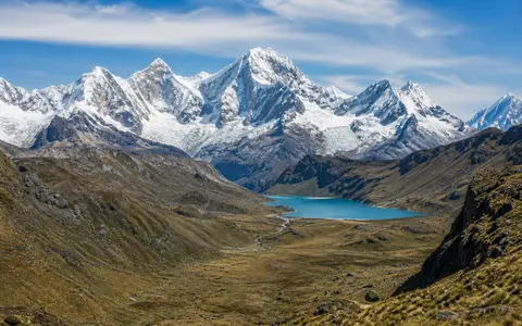
One range, several wider administrative areas
Cordillera Blanca—Spanish for “White Range”—is the established name used by Peru's glacier inventory and by UNESCO. “White Range” is an English translation, not a differently bounded feature. This page covers the physical mountain range, not only Huascarán National Park, the larger Huascarán Biosphere Reserve, or INAIGEM's 13,602 km² “area of influence.” The park protects much of the central range but is an administrative property; the influence area extends outward across adjoining catchments and settlements. The Cordillera Huayhuash, south of the Tuco–Conococha sector, is a separate range. (UNESCO MAB range description; INAIGEM influence-area map)
UNESCO traces the glacier-bearing mountains for approximately 180 km from Nevado Tuco in the south to the vicinity of Nevado Champará in the north. The older USGS glacier atlas describes a roughly 200 km northwest-trending range between approximately 8°08′–9°58′ S and 77°00′–77°52′ W. These are compatible generalized descriptions with different rounding and endpoints, not evidence that the bedrock range changed length. A single point coordinate would misrepresent this elongated landform; the coordinate envelope is offered only for orientation. (UNESCO MAB; USGS Professional Paper 1386-I)
The upper Santa River runs north through the Callejón de Huaylas along the range's western foot, with the Cordillera Negra on the opposite side of the valley. East of the crest, glacial valleys descend through the Conchucos highlands toward Marañón tributaries. Lake Conococha and the Tuco massif orient the southern end; the great bend of the Santa valley marks the northern transition in the USGS atlas.
A 6,768-metre summit above deeply incised massifs
Huascarán reaches 6,768 m above sea level, the highest elevation in Peru in UNESCO's record. Huandoy, Chopicalqui, Alpamayo, and other ice-covered massifs occupy the central and northern sectors, but summit elevation should not be confused with relief: elevation is height above sea level, whereas relief is the vertical difference within a chosen area. (UNESCO World Heritage Centre)
Swath profiles used in a 2016 geological study indicate local relief of about 3 km across the central and northern range, compared with about 1 km in the south. In the central sector, relief and maximum elevation are greater on the western flank than on the eastern flank, consistent with deeper incision toward the Callejón de Huaylas. Those figures are approximations derived from 10- and 30-km-wide topographic swaths, not direct cliff-height measurements. (Margirier and others, 2016)
The high crest is divided into massifs by transverse glacial troughs. Cirques—bowl-shaped glacier source hollows—cut into ridge heads; U-shaped valleys, hanging tributaries, sharp arêtes, and rock steps record former ice flow. Modern rivers have reworked the glacial valley floors and carry moraine and hillslope sediment toward the Santa and Marañón systems. (Margirier and others, 2016)
A young batholith in the footwall of a normal fault
The range's core is the Cordillera Blanca Batholith, a large body of magma that crystallized underground and was later exposed. Mapping summarized by Margirier and colleagues gives the exposed batholith a length of about 150 km and a width exceeding 15 km in parts of the north and centre. It intruded deformed Jurassic sedimentary rocks, so the granitic core and the older surrounding formations are different elements of the range.
Crystallization ages compiled in that study place emplacement between about 14 and 5 million years ago. Amphibole thermobarometry—estimating formation pressure from mineral chemistry—indicates emplacement depths of 3.1 ± 0.3 to 6.3 ± 0.8 km. The authors interpret the magma as a succession of sheet-like intrusions and infer that the batholith tilted eastward after about 5 million years ago. These numbers date and locate crystallization; they do not date the start of the Andes, whose broader tectonic history is much older. (Margirier and others, 2016)
The approximately 200 km Cordillera Blanca normal fault follows the western margin of the batholith. A normal fault is one on which the upper block moves down relative to the lower block: here the batholith forms the uplifted and exhumed footwall, while the Callejón de Huaylas basin lies in the hanging-wall block. This extension occurs inside an Andean belt built in the wider setting of Nazca Plate subduction. The same study finds faster exhumation during the past two million years and argues that fault displacement, glacial valley cutting, and erosional unloading acted together rather than assigning the present relief to one event. (Margirier and others, 2016)
14–5 Ma batholith
Young intrusive rock forms much of the high spine but cuts much older sedimentary country rock.
Normal-fault footwall
Extension helped raise and expose the batholith beside the subsiding Callejón de Huaylas basin.
Unequal glacial incision
Quaternary ice deepened central and northern valleys more strongly than the lower-relief southern sector.
A dated inventory, not a timeless ice total
INAIGEM's 2023 national inventory mapped 511 debris-free and debris-covered glaciers in the Cordillera Blanca with a combined area of 424.86 km². The result is a 2020 snapshot derived from Sentinel-2A imagery, interpreted at 1:25,000 scale with a minimum mapped area of 5,000 m²; smaller ice patches fall below that inventory threshold. It should therefore be reported with its image year and method. (INAIGEM, INGLOG II)
For change analysis, INAIGEM compared that 2020 result with a reanalysed 726.26 km² baseline from 1962 imagery. The mapped loss was 301.40 km², or 41.50%, over 58 years. An older USGS publication gives 723.4 km² from the 1962/1970-era inventory; the small difference from INAIGEM's 726.26 km² baseline reflects inventory treatment and should not be substituted into the newer percentage calculation. Glacier area is a plan-view measurement, not ice volume. (INAIGEM, INGLOG II; USGS historical inventory)
A high-resolution model for the upper Santa catchment, run for November 2008–October 2018, distinguishes short-lived snow from glacier ice. It found that seasonal snow below about 5,000 m was generally thin and ephemeral, while persistent seasonal snowpacks were concentrated above that elevation. Snowmelt was most important early in the dry season; ice melt became crucial later. These are model results for the upper Santa basin, not a measured snowline fixed across every slope of the range. (Fyffe and others, 2025)
Overdeepened basins with shifting inventories
Former glaciers excavated bedrock hollows and left ridges of unsorted debris called moraines. Water now occupies many of those basins, including the Parón basin and chains of smaller lakes in tributary valleys. Some lakes are impounded by moraine, others by bedrock, and many are no longer in contact with a modern glacier. Retreat can expose new depressions or join, enlarge, and drain existing waters, so both the number and area of lakes can change.
Lake totals also depend strongly on mapping rules. A 2021 comparison clipped several inventories to the same 3-km buffer around glacierized terrain and still found 385 Cordillera Blanca lakes in the ANA inventory, 882 in INAIGEM's inventory, and 803 in the 2019 projectGLOP inventory. The authors attribute much of the difference to image resolution, mapping dates, and the inclusion of smaller water bodies. For that reason, this page does not present “the number of lakes” as one timeless range statistic. (Wood and others, 2021)
Steep rock walls, mobile moraine sediment, earthquakes, and ice or rock entering a lake can produce rapid water-level change and, at some sites, outburst flooding. Susceptibility is lake-specific: the presence of a glacial lake or moraine alone does not establish that it will fail. Inventory geometry, dam material, freeboard, drainage, and the surrounding slopes must be assessed together. (Wood and others, 2021)
Pacific tributaries west, Amazon tributaries east
Much of the main crest is a continental watershed. West-flowing streams descend through short, steep valleys to the Santa, which runs north through the Callejón de Huaylas, turns west through the Cañón del Pato, and reaches the Pacific. The southern sector also supplies the Pativilca system, another Pacific drainage. East-flowing streams enter tributaries of the Marañón and continue through the Amazon system to the Atlantic. Within Huascarán National Park, UNESCO counts 41 tributaries distributed among the Santa, Pativilca, and Marañón basins; that is a park-bounded count, not a complete range inventory. (UNESCO World Heritage Centre; SIAR Áncash Santa basin map)
Rain, groundwater, seasonal snow, glacier ice, and lake storage contribute in different proportions from valley to valley. Monthly observations in the Yanamarey and Uruashraju glacier catchments during 1998/99 led Mark and Seltzer to estimate that glacier melt supplied 30–45% of annual proglacial-lake discharge; after downstream mixing, they conservatively estimated at least 10% of annual Santa discharge, with a larger relative role in the dry season. Those values describe sampled catchments and a historical glacier state, not every tributary today. (Mark and Seltzer, 2003)
The 2008–2018 upper-Santa model likewise found ice-melt inputs peaking at 44% in early August and remaining above 30% through most of early July to mid-September. This is the proportion of modelled catchment inputs, not a gauged percentage of river discharge at the coast. Both studies show the physical buffering effect: stored snow and ice release water when rainfall is scarce, while continued loss of glacier area reduces that storage and can increase seasonal variability. (Fyffe and others, 2025)
A wet austral summer and dry winter
The Cordillera Blanca lies in the outer tropics. Air temperature varies strongly with elevation and over the day, while the annual temperature cycle is comparatively small. Precipitation supplies the sharper seasonality: observations synthesized by Mark and Seltzer indicate that 70–90% of annual precipitation falls from October through March. Wet-season snow feeds high accumulation zones, but ablation—the loss of snow and ice through melt or sublimation—can occur in every month. (Mark and Seltzer, 2003)
At regional scale, easterly flow transports Atlantic moisture across the Amazon basin toward the central Andes during the wet season. Terrain then modifies that supply: uplift, valley winds, slope orientation, and elevation produce strong local differences in cloud and precipitation, so neither an eastern/western contrast nor a valley weather station represents the whole 180-km range. A modelling and station study on the western central-Andean slopes places most precipitation from October to April, with the main rainy season in December–February. (Trachte and others, 2018)
Glacier survival is therefore not explained by cold alone. Elevation controls whether wet-season precipitation falls as snow; cloud cover and fresh-snow albedo alter absorbed solar energy; humidity governs whether energy drives melt or sublimation; and aspect changes shading. These controls also explain why neighboring glaciers at similar latitude can have different areas, terminus elevations, and rates of retreat.
A mountain wall between two long valleys
The range forms the eastern wall of the Callejón de Huaylas and the western rim of high valleys leading toward the Marañón. Water and sediment move west through the Llullán–Parón, Quillcay, and other transverse valleys before joining the north-flowing Santa; east of the crest, separate headwaters descend through the Conchucos region. The northern and southern ends are gradual mountain transitions rather than surveyed lines, which is why different agencies give different rounded lengths.
The Cordillera Blanca is one sector of the Andes, but its 14–5-million-year-old batholith, western normal fault, concentrated tropical ice, and Santa–Marañón divide define a much narrower physical system. Use the Mountain Hub to compare it with other range-scale landforms.
Data sources and publications
- UNESCO Man and the Biosphere Programme. Huascarán Biosphere Reserve, accessed 30 August 2026. Tuco–Champará glacier extent, 6,768-m summit elevation, and distinction among range, park, and biosphere reserve.
- UNESCO World Heritage Centre. Huascarán National Park, accessed 30 August 2026. Park area and elevation range, high-peak context, glacial landforms, and the park-bounded Santa–Pativilca–Marañón tributary count.
- Morales-Arnao, B., and Hastenrath, S. L. Glaciers of Perú: Cordillera Occidental. U.S. Geological Survey Professional Paper 1386-I, 1998. Generalized coordinate envelope, approximately 200-km extent, drainage divide, and historical glacier inventory.
- Instituto Nacional de Investigación en Glaciares y Ecosistemas de Montaña (INAIGEM). Inventario Nacional de Glaciares y Lagunas de Origen Glaciar 2023 (INGLOG II). Huaraz, 2023. Sentinel-2A image year, mapping scale and threshold, 2020 glacier count and area, and the reanalysed 1962–2020 comparison.
- Margirier, A., Audin, L., Robert, X., Herman, F., Ganne, J., and Schwartz, S. Time and mode of exhumation of the Cordillera Blanca batholith (Peruvian Andes). Journal of Geophysical Research: Solid Earth 121 (2016), 6235–6249. Batholith dimensions, crystallization ages, emplacement depths, fault setting, relief profiles, and exhumation interpretation.
- Wood, J. L., and others. Contemporary glacial lakes in the Peruvian Andes. Global and Planetary Change 204 (2021), 103574. Cordillera Blanca lake counts under different inventory methods and guidance on cross-comparability.
- Mark, B. G., and Seltzer, G. O. Tropical glacier meltwater contribution to stream discharge: a case study in the Cordillera Blanca, Peru. Journal of Glaciology 49 (2003), 271–281. 1998/99 catchment observations, wet-season concentration, meltwater estimates, and downstream limits.
- Fyffe, C. L., and others. Thin and ephemeral snow shapes melt and runoff dynamics in the Peruvian Andes. Communications Earth & Environment 6 (2025), article 434. Upper-Santa model period, snow-persistence threshold, and seasonal snow- and ice-melt contributions.
- Trachte, K., Seidel, J., Figueroa, R., Otto, M., and Bendix, J. Cross-Scale Precipitation Variability in a Semiarid Catchment Area on the Western Slopes of the Central Andes. Journal of Applied Meteorology and Climatology 57 (2018), 675–694. Moisture transport, precipitation seasonality, and terrain-scale controls.
- SIAR Áncash. Cuenca hidrográfica del Río Santa—departamento de Áncash, map metadata dated 1 March 2022, accessed 30 August 2026. WGS84 basin map and the Santa's route through the Callejón de Huaylas and Cañón del Pato.