
Where the Lake Michigan name applies
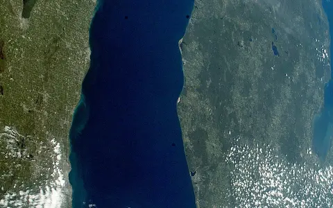
This record covers the named lake from the Straits of Mackinac south to the Chicago–Gary shore. It includes Green Bay, Little and Big Bays de Noc, Grand Traverse Bay, and the islands and shoals within the Lake Michigan outline. It does not treat the surrounding 118,000 km² land-drainage area, the combined Lake Michigan–Huron water body, or the state of Michigan as equivalent geographic units. Lake Michigan–Huron is a useful hydrological system name, not an alternate boundary for this page.[2][8][10]
The U.S. Geographic Names Information System records the official federal name Lake Michigan under feature ID 1623080 and supplies the locating coordinate 44.007874° N, 86.756451° W (44°00′28.346″ N, 86°45′23.224″ W). That point lies in open water west of Michigan's Lower Peninsula; it is a map locator, not a surveyed centroid, shoreline vertex, or legal boundary definition.[1]
Michigan borders the lake on the north and east, Wisconsin on the west, and Illinois and Indiana at the southwest and south. Door Peninsula separates Green Bay from the open lake; the Garden Peninsula and northern islands continue the same broad northeast–southwest structural grain. Grand Traverse Bay cuts into the northeastern coast, while the low southern end lies between Chicago and Indiana Dunes.
What the standard measurements describe
The coordinated Great Lakes table reports a 57,800 km² water area, 4,920 km³ volume, 85 m mean depth, and 282 m maximum depth. Volume and both depths are referenced to Low Water Datum. The same table gives a conventional maximum length of 494 km and breadth of 190 km. Because it does not define the endpoints or transects, those two figures orient the reader rather than establish survey-grade axes. Its 2,633 km shoreline includes islands and necessarily depends on map scale and the treatment of small indentations.[2]
NOAA currently uses 176.0 m (577.5 ft) on International Great Lakes Datum 1985 as the chart datum for both Lake Michigan and Lake Huron. Charted depth is measured below that reference surface; a gauge reading is the moving water surface relative to the datum. NOAA is preparing IGLD 2020 but, as of this review, still uses IGLD 1985 and tentatively schedules the replacement for 2027. The figures on this page therefore should not be silently relabeled with the forthcoming datum.[3]
Ridges divide the lake floor
NOAA's bathymetric compilation uses more than 600,000 historic U.S. hydrographic soundings and maps the lake at 1:250,000 with 5 m contours. The deepest part is the Chippewa Basin north of the lake's center, where contours exceed 275 m. South of the Two Rivers Ridge lies the shallower South Chippewa Basin; east of Milwaukee, the Mid-Lake Plateau rises to roughly 40–60 m below Low Water Datum at its shallowest mapped points. These are submerged landforms, not administrative regions.[4]
The Two Rivers Ridge arcs between Wisconsin and Michigan near Manitowoc and Ludington. Farther north, the Door–Leelanau Ridge crosses toward the Michigan coast, while north–south ridges and valleys continue through Grand Traverse Bay and the northern islands. The modern Straits overlie the drowned Mackinac Channel. A separate submerged channel crosses Green Bay from Little Bay de Noc to the Whitefish Delta, whose top is mapped at about 50–55 m depth. Together these features show that the lake floor preserves former outlets and river courses as well as glacially deepened basins.[4]
Deepest northern depression
Depths exceed 275 m near its southern end; the coordinated lake maximum is 282 m.
Bedrock and moraine ridges
Two Rivers and Door–Leelanau ridges interrupt the otherwise elongated north–south basin.
Channels beneath modern water
Mackinac and Whitefish channels record flow routes used during lower postglacial lake stages.
Ice enlarged a bedrock lowland
The basin did not originate in one event. Repeated Laurentide ice advances occupied an older drainage lowland, eroded weaker rock, and deposited till, sand, and gravel around the margins. During the late Wisconsin glaciation, readvancing ice left end moraines that extend onto the lake floor. NOAA interprets the Two Rivers Ridge as a moraine supported by resistant Devonian carbonate rock; the ridge probably checked the last major ice readvance into this part of the basin.[4]
Bedrock resistance helps explain the uneven floor. NOAA interprets the deep Chippewa Basin as erosion mainly into comparatively weak upper Silurian redbeds, bounded westward by resistant Silurian dolomite and eastward by Devonian carbonates. The Mid-Lake Plateau is a cuesta—a gently tilted bedrock ridge with one steep face—probably protected by resistant Devonian limestone. These interpretations are geological models based on relief and regional strata, not direct exposure across every buried part of the lake floor.[4]
As the ice withdrew, outlets shifted and the crust rose unevenly after removal of the ice load. Lake Chippewa, a low-water predecessor of modern Lake Michigan, drained through the Mackinac Channel; areas now tens of metres underwater were dry land or shallow channels. Later rising relative water levels drowned that landscape. There is consequently no single meaningful “birth date” for the modern lake: its basin, outlets, and shorelines developed through successive glacial and postglacial stages.[4][5]
Dunes, bluffs, barriers, and bedrock reaches
Shore materials vary around the lake. Resistant limestone and dolomite crop out along parts of the northern shore and islands, whereas thick unconsolidated glacial deposits dominate much of the southern basin. Waves cut those deposits into bluffs and release sand, silt, and clay. Currents move part of the sand alongshore; on broad beaches, onshore winds lift it inland to form dunes.[4][5]
The eastern and southern coasts contain several different dune types rather than one continuous sand wall. At Sleeping Bear, beach dunes form near lake level while perched dunes are windblown sand resting on high glacial headlands. Around Indiana Dunes, mapped dune–beach complexes preserve several shoreline generations; the modern complex began forming about 5,900 years ago in the cited USGS synthesis. Sand barriers also close or narrow former embayments, helping create the small lakes and wetlands just inland from parts of the Michigan shore.[5][6]
A narrow land basin and a reversible outlet
The coordinated land-drainage area is 118,000 km², only about twice the water area. Glacial uplands and drainage divides lie close to the western and southern shores, producing a comparatively narrow watershed there. The Fox–Wolf system reaches Green Bay through Lake Winnebago and the lower Fox River; the Menominee also enters Green Bay. On the eastern shore, the Manistee, Muskegon, Grand, Kalamazoo, and St. Joseph rivers drain broader parts of Michigan and northern Indiana. These are representative major tributaries, not a complete stream inventory.[2][10]
The principal natural outlet is the Straits of Mackinac. Michigan and Huron share a water level and function hydrologically as one lake, but the straits current is not a steady river. NOAA observations and models show overall transport from Michigan toward Huron while wind-driven currents reverse, on average, about once every 1.5 days; in summer, surface and deep flows can oppose one another. Water from the combined system ultimately leaves Lake Huron through the St. Clair River.[8][9]
Chicago's engineered connection is a second, much smaller route out of the Great Lakes basin toward the Illinois and Mississippi rivers. The governing U.S. Supreme Court decree limits Illinois diversion, including domestic pumpage, to an average 3,200 ft³/s (about 90.6 m³/s) over a 40-year accounting period. That number is an accounting limit, not a continuous observed discharge from the lake.[11]
Heating and wind reorganize the lake
Lake Michigan has a pronounced annual thermal cycle. In spring, shallow water warms first while deep water remains near the 4°C temperature of maximum freshwater density. A moving thermal bar, a narrow front between warmer stratified nearshore water and colder mixed offshore water, may persist for one to three months. By summer, warm surface water overlies cold deep water across the lake, separated by a thermocline, the depth zone where temperature changes rapidly. Autumn cooling and stronger mixing deepen and then erase that layer.[7]
Wind-driven transport dominates short-term circulation, but bottom shape, non-uniform winds, and temperature-density gradients modify it. The NOAA hydrodynamic study found stronger nearshore than offshore currents and distinct circulation cells associated with sub-basins and ridges. Hydraulic flow through Mackinac is at least an order of magnitude smaller than typical wind- and density-driven lake currents, so the direction of a local current cannot be inferred from the lake's long-term outlet alone.[7]
North–south reach creates contrasting seasons
The lake stores summer heat and releases it through autumn and early winter. When cold air crosses unfrozen water, it acquires heat and moisture; rising air can then produce narrow lake-effect snow bands on the downwind shore. Fetch is the distance air travels over open water. Along western Lower Michigan, the National Weather Service identifies fetch, wind direction, instability, wind speed, and moisture as key controls, with common westerly flow focusing snow east of the lake.[12]
Ice is spatially patchy and strongly variable between winters. Bays, harbors, and shallow nearshore water freeze more readily than the deep open basins, while storms fracture and redistribute existing ice. NOAA's lakewide series, assembled from Canadian Ice Service and U.S. National Ice Center products, runs from 1973 to the present. Within the published 1973–2018 comparison, Lake Michigan's annual maximum ranged from 12.4% cover in 2002 to 93.1% in 2014. Those are dated seasonal extremes, not a normal range guaranteed in any future winter.[13]
A moving surface works on mobile sediment
Michigan–Huron water levels respond over seasons and years to precipitation on the lakes, runoff, evaporation, upstream supply, St. Clair River outflow, diversions, and consumptive use. Wind and atmospheric-pressure changes add shorter local surges and seiches. Only Superior and Ontario have regulated lake outlets; 176.0 m Low Water Datum is therefore not a maintained target for Michigan. NOAA's conventional 99-year retention time is lake volume divided by mean outflow, not the residence time of every water parcel.[2][9]
High water and storm waves allow erosion to reach farther into bluffs and dunes; low water exposes more beach and can leave harbor channels too shallow. Eroded sand may move alongshore into beaches, bars, barriers, and dunes, while silt and clay can be carried offshore. Shore protection interrupts this exchange locally and may reduce the sand available down-current. The mapped shoreline is consequently a time- and scale-dependent boundary, one reason the standard area and shoreline length should remain qualified rather than presented as exact modern dimensions.[5][9]
The western branch of the upper Great Lakes
Lake Superior lies upstream of the Michigan–Huron system through the St. Marys River. Lake Michigan joins Lake Huron laterally at Mackinac; the principal eastward drainage then continues through the St. Clair River, Lake St. Clair, Detroit River, Lake Erie, Lake Ontario, and the St. Lawrence River. Treating Michigan as a named lake and Michigan–Huron as one hydraulic water body resolves the apparent conflict between geographical convention and water-level behavior.[8][9]
Compare the colder upstream Lake Superior, follow the shared-level connection into Lake Huron, or use the lake hub and terrain index to place Lake Michigan's basins, dunes, bluffs, islands, and drainage divides within the wider atlas.
Sources and measurement notes
- U.S. Geological Survey and U.S. Board on Geographic Names, Lake Michigan, Geographic Names Information System feature 1623080 (accessed 29 August 2026), with USGS's GNIS data-field explanation. Sources for the official federal name, feature identifier, locating coordinate, and the caution that GNIS coordinates locate rather than delimit a feature.
- NOAA Great Lakes Environmental Research Laboratory, Great Lakes Physical Characteristics (accessed 29 August 2026). Source for coordinated length, breadth, water and land-drainage areas, low-water volume and depths, island-inclusive shoreline, retention estimate, and outlet. The page identifies its source edition as Government of Canada/U.S. EPA, The Great Lakes: An Environmental Atlas and Resource Book, 3rd ed. (1995).
- NOAA Center for Operational Oceanographic Products and Services, Great Lakes Low Water Datums and International Great Lakes Datum (accessed 29 August 2026). Sources for the 176.0 m (577.5 ft) Lake Michigan and Huron chart datum on IGLD 1985, the meaning of the reference system, current datum status, and tentative 2027 release of IGLD 2020.
- NOAA National Centers for Environmental Information, Bathymetry of Lake Michigan and Lake Michigan Geomorphology (accessed 29 August 2026). The compilation uses more than 600,000 historic soundings at 1:250,000 and 5 m contours; the interpretation supplies the Chippewa basins, Mid-Lake Plateau, Two Rivers and Door–Leelanau ridges, Mackinac and Whitefish channels, bedrock framework, glacial readvance, and Lake Chippewa lowstand. It is not a navigation chart.
- U.S. Geological Survey, Geology of Indiana Dunes National Park (accessed 29 August 2026). Source for glacial retreat, the sequence of dune–beach complexes, the approximate 5,900-year age assigned to the modern complex, and movement of sand from eroding shores through waves, currents, beaches, and wind.
- U.S. National Park Service, Sleeping Bear Dunes National Lakeshore, Sand Dune Geology (updated 2025; accessed 29 August 2026). Source for beach, perched, falling, and de-perched dune terminology and for the relation between windblown sand, glacial headlands, and lag gravel.
- U.S. Environmental Protection Agency and NOAA Great Lakes Environmental Research Laboratory, Beletsky, D., Schwab, D. J., McCormick, M. J., Miller, G. S. and Saylor, J. H., Lake Michigan Mass Balance Study: Hydrodynamic Modeling Project, EPA 905-R-01-007 (May 1999; accessed 29 August 2026), especially pp. 13 and 21–24. Source for the thermal bar, summer stratification, fall mixing, dominant wind-driven transport, effects of basin relief and density gradients, current contrasts, and relative scale of hydraulic and internal lake flow.
- NOAA Great Lakes Environmental Research Laboratory, Predicting Currents in the Straits of Mackinac (accessed 29 August 2026). Source for the shared Michigan–Huron water body, overall Michigan-to-Huron transport, wind-driven reversals averaging about 1.5 days, and opposing surface and deep flows in summer.
- International Joint Commission, Chiasson, C. and Bunch, K., Building Resilience along Lake Michigan and Huron Shorelines (13 October 2020), and Controlling Water Levels on Lake Michigan–Huron Is a Tricky Business (17 October 2013; both accessed 29 August 2026). Sources for the single hydraulic lake, water-balance controls, unregulated Michigan–Huron outlet, storm and seasonal effects, and the interaction of water level, erosion, and sediment supply.
- U.S. Geological Survey, Hydrologic Unit Names and Descriptions (accessed 29 August 2026), Lake Michigan subregions 0403–0406; and Peters, C. A., ed., Environmental Setting and Implications for Water Quality in the Western Lake Michigan Drainages, Water-Resources Investigations Report 97-4196 (1997; accessed 29 August 2026). Sources for lake, bay, island, and drainage-basin scope and for the principal western tributary systems.
- U.S. Army Corps of Engineers, Chicago District, Lockport Lock, Dam & Controlling Works Water Control Manual, revision 2 (9 May 2024; accessed 29 August 2026), pp. 3-8–3-9. Source for the 3,200 ft³/s decree limit, 40-year accounting period, inclusion of domestic pumpage, and diversion-measurement responsibility.
- National Weather Service Grand Rapids, The Importance of Wind Direction in Forecasting Lake Effect Snow (accessed 29 August 2026). Source for fetch, wind direction, instability, moisture, and the downwind distribution of Lake Michigan snow bands.
- NOAA Great Lakes Environmental Research Laboratory, Great Lakes Ice Cover and Great Lakes Ice Cover Database (1973–present; accessed 29 August 2026). Sources for agencies and methods behind the historical series, annual variability, and the dated Lake Michigan maximum-cover extremes reported for 1973–2018.