.png)
The lake, not the wider Sahtú region
The Geographical Names Board of Canada lists Great Bear Lake as the official English name for the lake polygon; the French pan-Canadian form is Grand lac de l'Ours. Parks Canada records Sahtú as the North Slavey name used by the people of Délı̨nę. Tsá Tué is also used for Great Bear Lake in current federal conservation material.[1][2][7]
This record is confined to the connected water body and its immediate basin form. The Sahtú Settlement Area is an administrative and land-claim region extending beyond the shore, while the UNESCO-designated Tsá Tué Biosphere Reserve includes Great Bear Lake and part of its watershed. Those wider areas should not be assigned the lake's 31,153 km² surface measurement.[2][7]
Five arms around deep open water
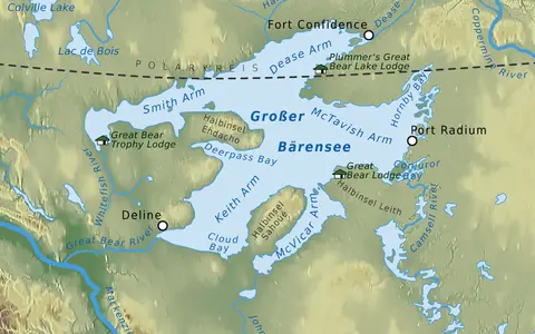
The lake lies east of the Mackenzie River valley and northwest of Great Slave Lake. Its northwestern Smith Arm and northeastern Dease Arm extend beyond the Arctic Circle. Moving clockwise from the outlet, the other principal divisions are eastern McTavish Arm, southern McVicar Arm, and southwestern Keith Arm. Délı̨nę, the only community on the shore, stands beside Keith Arm near the outlet.[2][3]
Saoyú and ʔehdacho are large peninsulas projecting into the western and southern lake respectively; together they separate long reaches of open water and help define Keith and McVicar arms. At a typical surface elevation near 156 m above sea level, the 446 m maximum depth places the deepest surveyed floor roughly 290 m below sea level. That deep water is concentrated in McTavish Arm rather than distributed evenly beneath all five arms.[2][3]
Older valleys enlarged by ice, then tilted by rebound
The lake did not originate as one simply excavated bowl. Pleistocene Laurentide ice widened and deepened pre-existing valleys, while the underlying rock boundary influenced which sectors resisted erosion. Precambrian Shield rocks reach the eastern margins of Dease and McTavish arms. Westward, a narrower belt of Ordovician carbonate and clastic rocks gives way to the lower-relief Interior Plains, where glacial till overlies younger sedimentary strata.[3][4]
During deglaciation, parts of the Great Bear basin belonged to glacial Lake McConnell, a changing ice-marginal lake that occupied portions of the Great Bear, Great Slave, and Athabasca basins between about 11,800 and 8,300 years ago. Those dates describe the wider proglacial-lake sequence, not an exact age for the present shoreline. As the land rose after removal of the ice load, changing gradients shifted the outlet from Smith Arm to the western end of Keith Arm and left raised former shorelines above today's lake.[4][5]
Exposed Shield rock
Resistant Precambrian terrain produces islands, rocky headlands, and deep irregular water in the eastern arms.
Ordovician rock belt
Carbonate and clastic strata lie between the old Shield and the younger sedimentary terrain farther west.
Interior Plains low relief
Glacial deposits and gentler terrain lead toward Keith Arm, the outlet, and the Mackenzie valley.
A small land catchment and a long replacement time
The World Lake Database gives 114,717 km² for the surrounding land catchment. Adding the 31,153 km² lake surface produces approximately 146,000 km² for the whole lake-and-land watershed, the scope used by a 2024 limnological study. The values are therefore compatible rather than competing basin boundaries. The three largest tributaries identified in that study are the Camsell River into McTavish Arm, the Whitefish River into Smith Arm, and the Johnny Hoe River into McVicar Arm.[3][4]
Water leaves Keith Arm through the Great Bear River, flows west to the Mackenzie River near Tulita, and ultimately reaches the Beaufort Sea. A 2024 synthesis uses about 17 km³ per year as mean outflow—equivalent to roughly 540 m³/s as an annual mean—and estimates a bulk water residence time near 130 years; the older World Lake Database value is 124 years. Both are whole-lake replacement estimates derived from volume and mean outflow, not the travel time of a parcel or the age of every part of the lake.[3][4]
The lake's storage dampens seasonal discharge. The Northwest Territories' 2022 water assessment notes that a 0.40 m level change represents about 12.5 km³ of water and that levels generally fall through winter because river inflow is small while Great Bear River continues to drain the lake. Year-long 2008–2009 pressure records also captured wind forcing and basin seiching—oscillation of the water surface and water column within the basin.[3][6]
One lake with several thermal regimes
Satellite studies covering years between 2000 and 2009 placed average melt onset around 19–23 May, complete ice clearance around 2–10 July, and freeze onset around 14–17 November, with full cover near 29 November. These are period averages, not a fixed calendar: in the 2008–2009 mooring year, complete freeze-up occurred by 24 November and ice cleared between 12 and 15 July, about 230 days later. Melt and freeze also progress differently among the arms and open central water.[3]
The deep central lake generally remains below 4°C and completes one major annual overturn, the full vertical mixing of its water column. Shallow arms and nearshore water can warm above 4°C and develop summer density layers, especially in Keith, Smith, McVicar, and McTavish arms. Because one “cold-monomictic” label hides this spatial contrast, the 2024 study proposes calling Great Bear a polar lake with a hybrid circulation regime. Ice cover, basin depth, inflowing river warmth, solar heating, and wind therefore interact rather than imposing one uniform temperature cycle.[3]
A western-Arctic storage basin
Great Bear Lake is a large lateral reservoir within the Mackenzie system, not the source of the Mackenzie River itself. Great Slave Lake lies on the river's main upstream chain; Great Bear joins from the east through its tributary river. This distinction explains why Great Bear can have enormous storage but a catchment only a few times the area of its own surface.[3][6]
The lake hub places it among other large through-flow basins, while the terrain index connects its raised shorelines, glacial deposits, rock margins, and lowland outlet. For the closest physical comparison, Great Slave Lake shares the Shield–Plains boundary and long winter ice but differs in basin geometry and in its position on the Mackenzie's main stem.
Sources and measurement notes
- Geographical Names Board of Canada, Great Bear Lake, Canadian Geographical Names Database key LAJMV (record modified 16 February 2021), and Natural Resources Canada, Geographical Names of Pan-Canadian Significance (accessed 29 August 2026). Sources for the official English and French forms, lake classification, Northwest Territories location, and 65.833547° N, 120.751706° W coordinate. The database describes the feature as a polygon and assigns the coordinate a 1:5,000,000 relevance scale; the page therefore treats it as a representative map reference, not a surveyed centroid.
- Parks Canada and the Saoyú-ʔehdacho Management Board, Saoyú-ʔehdacho National Historic Site Management Plan 2016 (accessed 29 August 2026). Source for the North Slavey name Sahtú, Délı̨nę's relationship to the lake, the positions and areas of Saoyú and ʔehdacho, the approximately 156 m lake-surface elevation, and the distinction between the lake and Sahtú Settlement Area.
- Carmack, E. C. et al., “Seasonal Temperature and Circulation Patterns in a Hybrid Polar Lake, Great Bear Lake, Canada,” Journal of Geophysical Research: Earth Surface 129, e2024JF007650 (2024; accessed 29 August 2026). Source for the 31,153 km² area, 71 m mean and 446 m maximum depths, 2,236 km³ volume, five-arm arrangement, three largest tributaries, 146,000 km² whole-watershed scope, approximately 17 km³/year mean outflow, approximately 130-year residence time, geological transition, satellite ice dates, 2008–2009 observations, and hybrid polar-lake circulation. The area is a published morphometric value, not a dated shoreline survey.
- International Lake Environment Committee Foundation, Great Bear Lake (NAM-30), World Lake Database (accessed 29 August 2026). Source for the 114,717 km² land-catchment figure, 124-year residence estimate, physical dimensions, Shield–Plains geology, glacial enlargement of pre-existing valleys, rebound, former shorelines, and outlet change. The profile compiles older Fisheries and Oceans Canada, Geological Survey of Canada, and 1974 Canadian Hydrographic Service material; newer ice and circulation results are taken from reference 3.
- Smith, D. G., “Glacial Lake McConnell: Paleogeography, age, duration, and associated river deltas, Mackenzie River basin, western Canada,” Quaternary Science Reviews 13(9–10), 829–843 (1994; accessed 29 August 2026). Source for the 11.8–8.3 thousand-year-before-present duration of the changing glacial Lake McConnell system and its staged occupation of parts of the Great Bear basin. Those ages are not assigned to the modern Great Bear shoreline.
- Government of the Northwest Territories, Department of Environment and Climate Change, NWT State of the Environment Report 2022: State—Water, section 11.5 (accessed 29 August 2026). Source for winter level behavior, the 0.40 m level-change equivalent of about 12.5 km³, continuous Great Bear River outflow, and the lake's tributary connection to the Mackenzie River. The page reports no significant trend for the 1984–2018 Hornby Bay record; this article does not extrapolate that finding beyond its observation period.
- Environment and Climate Change Canada, Important first step taken to establish new Indigenous Protected and Conserved Area around Great Bear Lake (17 December 2022), and UNESCO, Tsá Tué Biosphere Reserve, Man and the Biosphere Programme (designated 2016; accessed 29 August 2026). Sources for current Tsá Tué usage and for the reserve's inclusion of Great Bear Lake and part of its watershed; the designated reserve is not the same boundary as the water body.