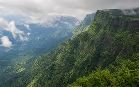
Landform, region, and World Heritage property
Western Ghats is the accepted geographic name; Sahyadri is a traditional alias and is especially common in Maharashtra and adjoining sectors. This record uses the name for the physical escarpment and connected highlands along the western rim of the Indian Peninsula. It does not use a state boundary, watershed boundary, forest zone, or elevation contour as a substitute for the landform.
That distinction matters because no universally accepted polygon encloses the Ghats. The Ministry of Environment and Forests' 2013 High Level Working Group report reviewed competing geological, geomorphological, ecological, and administrative definitions. Its own 164,280 km² “Western Ghats Region” follows the outer limits of 188 talukas in six states and reaches 22°26′ N; it is an administrative study region, not the area of the mountain system.
The UNESCO Western Ghats World Heritage property is narrower in a different way: it consists of 39 protected-area components with a combined property area of 795,315 hectares (7,953.15 km²). The property lies within the wider Ghats but is not synonymous with them. Because published areas measure unlike boundaries, this page does not present one timeless “area of the Western Ghats.”
From the Tapi margin to the southern highlands
The physical range begins as a pronounced escarpment south of the Tapi estuary and valley in Gujarat, crosses Maharashtra, Goa, Karnataka, Kerala, and Tamil Nadu, and continues through the southern highlands toward Kanyakumari. The older physiographic envelope reproduced in the 2013 report is approximately 8°–21°06′ N and 73°–78° E. UNESCO describes a roughly 1,600 km coast-parallel stretch generally 30–50 km inland; the ministry report uses 1,500–1,600 km. These are regional spans, not measurements along every bend of a single ridge.
The relief is strongly asymmetric. Short, steep valleys cut west through the escarpment toward the Konkan, Kanara, and Malabar coastal lowlands. East of the crest zone, the land generally falls more gradually through the Maharashtra, Karnataka, and adjoining plateaus into the Godavari, Krishna, and Kaveri basins. The continental drainage divide does not coincide everywhere with the sharpest cliff or highest summit, so “crest,” “escarpment,” and “watershed” should not be treated as one mapped line.
Relief also changes along strike. Flat-topped basalt plateaus and stepped scarps dominate much of Maharashtra. Goa and Karnataka contain deeply dissected ridges, headwater amphitheatres, and locally projecting massifs. Southward, the Nilgiri upland rises near the meeting of western and eastern peninsular highlands; the low, approximately 30 km-wide Palakkad (Palghat) Gap then separates it from the Anaimalai highlands. The Palani and Cardamom Hills form adjoining southern uplands, but local range names remain more precise than calling every ridge simply “Western Ghats.”
Anamudi and the one-metre source discrepancy
Anamudi in Kerala's Eravikulam National Park is the accepted high point. The Kerala Forest Department's National Parks page gives 2,695 m, while its state overview gives 2,694 m. The 2013 ministry report also uses 2,695 m.
None of those pages specifies the survey edition, measurement method, or vertical datum, so the one-metre difference cannot be resolved by averaging the figures. This page therefore reports about 2,695 m. It also avoids attaching a coordinate for the entire range to Anamudi: a summit point is useful for the high point, not as the representative location of a 1,500–1,600 km landform.
Flood basalts in the north, older shield rocks farther south
North of Goa, the escarpment cuts through the Deccan Traps, a stack of Late Cretaceous to Palaeocene basalt lava flows erupted at about 65 million years ago. The International Union of Geological Sciences' Deccan Traps record estimates that about 2 km of basalt remains in the Western Ghats escarpment, including subsurface thickness. At Mahabaleshwar, it describes an approximately 1,200 m sequence of about 50 flows. Horizontal lava packages, joints, weathering horizons, and resistant flow interiors help produce benches, cliffs, and flat-topped plateaus.
Central and southern sectors expose much older parts of the Indian shield rather than one continuous volcanic pile. The Karnataka plateau includes Archean gneisses and greenstone belts; farther south, high-grade crystalline rocks of the Precambrian shield underlie the highlands. Rock strength, foliation, joints, faults, and deep tropical weathering influence whether a sector develops narrow ridges, rounded massifs, broad uplands, or deeply incised valleys. “Western Ghats” is therefore a physiographic name spanning several rock provinces, not a single stratigraphic unit.
Layered basalt scarps
Deccan lava flows support stepped slopes, mesas, cliffs, and lateritic plateau surfaces.
Ancient cratonic terrain
Gneiss, greenstone belts, fractures, and differential weathering diversify the Karnataka relief.
Crystalline high massifs
Nilgiri, Anaimalai, Palani, and Cardamom uplands contain the range's highest terrain.
Rifting raised the margin; erosion keeps reshaping it
The Ghats occupy India's western passive margin, a continental edge no longer at an active plate boundary. A 2021 Scientific Reports study relates the margin to separation of Madagascar from India at about 88 million years ago and separation of the Seychelles at about 65 million years ago, when Deccan volcanism affected the northern sector. It interprets magmatic material added at the base of the crust as one mechanism contributing to broad uplift.
The timing and balance of uplift mechanisms remain debated, so the escarpment should not be described as a single fault face created in one event. Rift-shoulder uplift, magmatic underplating, flexural response to erosion and offshore sediment loading, and later denudation have all been proposed. A 2008 Geological Society of India analysis emphasizes that the mature crystalline-rock escarpment is now strongly controlled by inherited bedrock structure and unequal erosion on its two sides.
That unequal erosion maintains the characteristic cross-section. West-flowing streams have a nearby sea-level base and cut short, steep valleys into the escarpment. Inland streams descend toward more distant base levels across the plateau. Headward erosion, weathering, rockfalls, debris movement, and river incision continue to alter scarps and divides, but at different rates from one rock sector and catchment to another.
Independent coastal rivers and peninsula-crossing basins
West of the divide, rivers commonly descend directly to the Arabian Sea without combining into one trunk system. The India Water Resources Information System's Tapi-to-Tadri basin report maps separate systems including the Damanganga, Vaitarna, Ulhas, Savitri, Vashishti, Mandovi, Kali, and Gangavali. Its Tadri-to-Kanyakumari report identifies 43 river systems and includes the Netravati, Bharathapuzha, Periyar, and Pamba. These basin groupings extend beyond the mountain slopes; they do not define the range boundary.
The gentler inland side feeds much longer routes. The Godavari rises near Trimbakeshwar on the eastern side of the northern Ghats, while the Krishna begins near Mahabaleshwar. The Kaveri and major tributaries such as the Kabini and Bhavani gather water from the southern uplands. They carry runoff east or southeast across the plateau toward the Bay of Bengal, giving the peninsula an asymmetric drainage pattern.
Monsoon seasonality changes channel work. Wet-season runoff increases discharge, sediment transport, waterfall flow, and incision in steep western catchments; dry-season flow contracts and becomes more dependent on soil and groundwater storage, reservoirs, and releases. Because catchment area, rainfall, bedrock permeability, and regulation differ, “west-flowing” does not mean every river has the same seasonal regime.
A strong monsoon gradient, not one rainfall value
During the southwest monsoon, moist Arabian Sea air rises against the western face and crest zone. The resulting cooling and condensation enhance rainfall on exposed slopes. Air crossing the divide then descends toward the interior, where warming and reduced moisture contribute to a rain shadow. Latitude, elevation, slope orientation, distance from the coast, and gaps make the effect spatially uneven.
India Meteorological Department station normals show the scale of the contrast without pretending to be range-wide averages. For 1981–2010, coastal-windward Honavar averaged 3,712.4 mm of annual rainfall, while inland Chitradurga, east of the central Ghats, averaged 660.9 mm. Honavar received most of its normal rainfall from June through September. These are station means for a stated 30-year period, not timeless flank totals.
Heavy rainfall also drives active slope processes. The Geological Survey of India's landslide guidance identifies the Western Ghats and Nilgiris as landslide-prone terrain and notes that Indian landslides are most often triggered by monsoon rain. Triggering is not uniform: slope angle, rock and soil type, fractures, geomorphology, drainage concentration, and land cover influence whether saturation produces shallow soil slips, debris flows, or deeper failures.
Data sources and publications
- High Level Working Group, Ministry of Environment and Forests, Government of India. Report of the High Level Working Group on Western Ghats, Volume I (2013), especially chapters 1, 4, and 5. Accepted name and Sahyadri alias, competing delimitations, physiographic envelope, range extent, state sequence, Palakkad Gap, rock provinces, and the distinct 188-taluka study region.
- UNESCO World Heritage Centre. “Western Ghats” (inscribed 2012; accessed 30 August 2026). Approximate 1,600 km extent, position relative to the coast, six-state distribution, Palghat Gap width, monsoon role, and the area and component structure of the serial World Heritage property.
- Kerala Forest Department. “National Parks—Eravikulam National Park” and “Kerala at a Glance” (accessed 30 August 2026). The department's differing 2,695 m and 2,694 m Anamudi elevations.
- Mandal, B., Vijaya Rao, V., Karuppannan, P., and Laxminarayana, K. “Mechanism for epeirogenic uplift of the Archean Dharwar craton, southern India as evidenced by orthogonal seismic reflection profiles,” Scientific Reports 11 (2021), article 1499, DOI 10.1038/s41598-021-80965-7. Passive-margin setting, crustal rock provinces, breakup ages, eastward drainage, and uplift interpretation.
- Gunnell, Y., and Harbor, D. “Structural Underprint and Tectonic Overprint in the Angavo (Madagascar) and Western Ghats (India)—Implications for Understanding Scarp Evolution at Passive Margins,” Journal of the Geological Society of India 71(6) (2008), 763–779. Lithologic control, unequal erosion, drainage base levels, and residual-escarpment interpretation.
- International Union of Geological Sciences. “Deccan Traps” (accessed 30 August 2026). Eruption age, preserved Western Ghats basalt thickness, Mahabaleshwar section thickness and flow count, and weathered ferricrete surfaces.
- India Water Resources Information System. West Flowing Rivers from Tapi to Tadri Basin, Version 2.0, and West Flowing Rivers from Tadri to Kanyakumari Basin, Version 2.0 (accessed 30 August 2026; derived in part from the 2012 River Basin Atlas of India). Coastal basin limits, independent river systems, source highlands, and drainage direction.
- India Meteorological Department. Honavar climatological table and Chitradurga climatological table, 1981–2010 normals (accessed 30 August 2026). Annual and monthly rainfall used for the central-sector windward–interior comparison.
- Geological Survey of India, Bhusanket. “Landslide FAQs” (accessed 30 August 2026). Landslide-prone regions, terrain controls, and monsoon rainfall as the principal trigger in India.