
Which mountains the name includes
Transantarctic Mountains is the accepted English name in the U.S., U.K., New Zealand, and Russian records assembled by the SCAR Composite Gazetteer of Antarctica. Scientific literature often abbreviates it to TAM; the British record also preserves the older variant Transantarctic Mountain System. Neither term denotes a second range. (SCAR-hosted U.S. gazetteer record; SCAR-hosted U.K. gazetteer record)
This page uses the broad gazetteer scope: the continuous but separately named groups west of the Ross Sea and along the western and southern Ross Ice Shelf margins, followed through the Horlick and Thiel Mountains, Pensacola Mountains, Shackleton Range, and Theron Mountains to Coats Land. The Victoria Land ranges, Queen Alexandra Range, and Queen Maud Mountains are components of this system, not aliases for the whole. The Antarctic Peninsula, Ellsworth Mountains, Prince Charles Mountains, and ice-buried Gamburtsev Subglacial Mountains are separate features.
A single coordinate cannot locate a 3,000-km-scale arc. The U.K. catalogue assigns 85°00′S, 175°00′W, but labels its precision and location method as unknown; it should be treated as a map-label position, not a surveyed centroid or endpoint. Administrative claim sectors likewise do not define the physical boundary of the range.
Why published lengths and heights differ
The British Antarctic Survey's February 2026 statistics give a length of 3,300 km, based on its current compilation using Antarctic Digital Database version 7.11, Bedmap3, and REMA version 2 among its sources. A 1989 U.S. Geological Survey continent map described the broad belt as more than 3,500 km. These are rounded end-to-end descriptions, not cadastral measurements: the visible rock is interrupted by ice, and studies that stop at the Pensacola Mountains rather than carrying the system through the Shackleton Range and Theron Mountains necessarily measure a shorter feature. The 3,300-km value is therefore used here as the current compiled estimate, while the older 3,500-km figure remains a legitimate broader rounding rather than a second physical length. (BAS Antarctic Factsheet, February 2026; USGS Map I–1992)
Mount Kirkpatrick in the Queen Alexandra Range is the highest listed summit. BAS and the U.S. gazetteer give an elevation of 4,528 m at approximately 84°20′S, 166°25′E; the New Zealand gazetteer gives 4,518 m at the same nominal position. Both catalogue records say the coordinate precision and source method are unknown, neither states a vertical datum, and BAS cautions that some Antarctic mountain heights come from surveys of variable accuracy. Reporting 4,528 m follows the current BAS compilation, but the 10-metre disagreement is retained rather than presented as resolved. (U.S. Mount Kirkpatrick record; New Zealand Mount Kirkpatrick record)
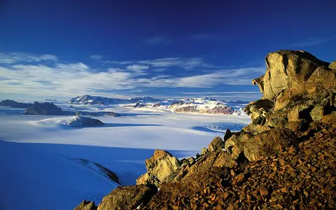
Relief is asymmetric. In much of the Ross sector, steep seaward escarpments face the rifted Ross Embayment while the inland flank tilts more gently beneath the East Antarctic Ice Sheet. Plateau surfaces, sharp rock walls, broad névés (high snow-accumulation fields), and deep glacier troughs occur side by side. A nunatak is a summit or ridge projecting through surrounding ice; because ice conceals the lower slopes and many links between ranges, exposed peaks alone understate the system's bedrock continuity.
Old basement, sedimentary platforms, and Jurassic magma
The exposed geology is layered in time. In the central Transantarctic Mountains, metamorphic and igneous basement records the Ross Orogeny, a mountain-building episode principally active about 540–480 million years ago. Above an eroded basement surface lies the mainly continental Beacon Supergroup, a Devonian-to-Triassic succession of sandstone and related sedimentary rocks. Early Jurassic mafic lavas of the Ferrar Group overlie parts of that succession, while Ferrar Dolerite forms abundant sills and dikes through it. These mafic rocks are associated with the early breakup of Gondwana. (Goodge, 2010)
This arrangement helps explain the range's characteristic benches, cliffs, and flat-topped massifs. Relatively flat sedimentary beds and resistant dolerite sheets can weather into repeated steps, whereas glaciers exploit fractures and weaker zones to excavate troughs. The sequence is not uniform everywhere: rare older Archean–Proterozoic rocks crop out around the Nimrod Glacier area, and large sectors remain known mainly from magnetic, gravity, seismic, and radar surveys because bedrock is buried by ice.
Ross-age mountain roots
Deformed and intruded rocks preserve an early Paleozoic convergent-margin history.
Beacon sedimentary succession
Devonian–Triassic strata record long intervals of erosion and deposition on Gondwana.
Ferrar sills and lavas
Jurassic mafic rocks mark crustal extension during Gondwana's breakup.
A rift shoulder with a non-uniform history
The modern Transantarctic Mountains are not chiefly a young collision belt. They stand along the boundary between thick East Antarctic cratonic crust and the extended, thinned crust of the West Antarctic Rift System and Ross Sea basins. A rift flank is the raised edge beside extended continental crust. Range-parallel normal faults, crustal flexure, erosion, and isostatic response all contributed to the present relief; the relative importance of those processes varies along the system. (Goodge, 2010; Paxman and others, 2019)
Thermochronology supplies local timing rather than one range-wide uplift date. At Mount England in southern Victoria Land, an apatite fission-track profile indicates that uplift began at about 55 million years ago; the same study inferred roughly 6 km of rock uplift and 4.5–5 km of erosion along its local maximum-uplift axis. Those values describe a studied sector and reconstructed rock history—not the present elevation of Mount England and not uniform uplift everywhere in the Transantarctic Mountains. (Fitzgerald, 1992)
Later ice repeatedly reshaped the inherited rift-margin topography. A 2019 reconstruction of the Wilkes Subglacial Basin–Transantarctic Mountains sector found that most modeled post-34-million-year glacial erosion and landscape development occurred before 14 million years ago. The authors also found that a single uniform-flexure model cannot reproduce variations along the mountain front; crustal structure and localized erosion-driven flexural uplift matter. This is why “rift-flank uplift” is a useful framework, but not a complete one-process explanation.
Outlet glaciers cut across the mountain axis
The range constrains East Antarctic ice flow without sealing it off. Ice from the high interior is funneled through bedrock troughs as outlet glaciers. On the Ross side, David Glacier reaches the Ross Sea, while Mulock, Byrd, and Nimrod glaciers enter the Ross Ice Shelf. A remote-sensing study mapped the four catchments at about 1.53 million km² combined—approximately 12% of the Antarctic Ice Sheet by area. That number is the modeled catchment area of those four glaciers, not the area of the mountain system or a current annual discharge. (Stearns, 2011)
Farther south, other troughs connect plateau ice with the southern Ross Ice Shelf, while openings near the Weddell end feed the Filchner–Ronne system. These ice corridors divide the rock belt into its named ranges and carry eroded debris toward shelves and embayments. They also prevent the range from being treated as an uninterrupted continental drainage divide. Changes at the Ross Ice Shelf can alter the back stress, or buttressing, acting on glaciers entering it, although the cited study notes that observations of these outlets remain sparse.
Liquid-water drainage is local and seasonal. In the McMurdo Dry Valleys, summer melt from surrounding glaciers supplies short streams and ice-covered lakes on valley floors. This water system occupies only a small, unusually ice-free sector and should not be generalized to the full range, where glacier ice—not river flow—is the dominant form of drainage. (Doran and others, 2002)
Altitude, exposure, and topographic winds
No single temperature or snowfall figure represents the entire system. The range spans coastal, ice-shelf, and high-interior settings; elevation, distance from maritime moisture, slope orientation, and wind redistribution change accumulation sharply. Snow can be scoured from ridges while deep ice fills an adjacent trough, so bare rock does not by itself indicate a warm site.
The McMurdo Dry Valleys provide a measured local example. Victoria, Wright, and Taylor valleys lie between the East Antarctic Ice Sheet and McMurdo Sound and together cover about 4,800 km². A 2010 meteorological study reported annual precipitation below 50 mm water equivalent and mean annual air temperatures from −14.8°C to −30°C among seven valley-floor automatic weather stations, depending on station and measurement period. Those are dry-valley observations, not range-wide normals. (Speirs and others, 2010)
The same work corrects a common terminology problem: the dry valleys' abrupt warming events are often caused by foehn winds—air driven across and down the mountains by regional pressure gradients and modified by topography—not simply by katabatic drainage of cold, dense air from the plateau. Foehn events produce rapid warming and drying and affect landscape-forming processes; in summer, coastal airflow and solar heating can instead support brief meltwater flow. This wind contrast helps maintain exposed terrain beside glacier-filled valleys.
How to read the range on an Antarctic map
From north to south, the system fronts the Ross Sea in Victoria Land, borders the western and southern Ross Ice Shelf, then turns through isolated ranges toward the Filchner Ice Shelf and Coats Land. Inland lies the East Antarctic Ice Sheet; toward the Ross Embayment lies the rifted West Antarctic sector. The terms East and West Antarctica describe broad physiographic and geologic regions, not a precise crest-line border at every point.
Rock exposure, subglacial bedrock, and ice flow must therefore be read together. The visible chain is discontinuous, the geological boundary continues beneath ice, and the hydrological connections cross the apparent divide. Return to the Mountain Hub for other range-scale landforms.
Data sources and publications
- Scientific Committee on Antarctic Research Composite Gazetteer, hosted by the Australian Antarctic Data Centre. Transantarctic Mountains: United States Gazetteer record and United Kingdom Gazetteer record, accessed 30 August 2026. Accepted name, broad range membership, historical variant, and representative catalogue position.
- British Antarctic Survey. Antarctic Factsheet: Geographical Statistics, February 2026. The 3,300-km length and 4,528-m Mount Kirkpatrick figure; document sources include Antarctic Digital Database 7.11, Bedmap3, and REMA v2.
- Australian Antarctic Data Centre / SCAR Composite Gazetteer. Mount Kirkpatrick: United States Gazetteer record and Mount Kirkpatrick: New Zealand Gazetteer record, accessed 30 August 2026. Alternative elevation values and coordinate-precision notes.
- Alpha, T. R., and Ford, A. B. Oblique Maps of Antarctica, U.S. Geological Survey Map I–1992, 1989; map plate and explanatory text. Historic extent estimate, continental setting, and outlet-glacier connections.
- Goodge, J. W. Glimpses of East Antarctica: Aeromagnetic and satellite magnetic view from the central Transantarctic Mountains, Journal of Geophysical Research: Solid Earth 115 (2010). Crustal boundary, Ross Orogen basement, Beacon Supergroup, Ferrar rocks, and rift setting.
- Fitzgerald, P. G. The Transantarctic Mountains of southern Victoria Land: The application of apatite fission track analysis to a rift shoulder uplift, Tectonics 11 (1992), 634–662. Local uplift timing, magnitude, erosion, and fault architecture.
- Paxman, G. J. G., and others. The Role of Lithospheric Flexure in the Landscape Evolution of the Wilkes Subglacial Basin and Transantarctic Mountains, East Antarctica, Journal of Geophysical Research: Earth Surface 124 (2019), 812–829. Flexural modeling and post-34 Ma erosion history.
- Stearns, L. A. Dynamics and mass balance of four large East Antarctic outlet glaciers, Annals of Glaciology 52(59) (2011), 116–126. Catchment boundaries, destinations, and remote-sensing methods for David, Mulock, Byrd, and Nimrod glaciers.
- Speirs, J. C., and others. Foehn Winds in the McMurdo Dry Valleys, Antarctica: The Origin of Extreme Warming Events, Journal of Climate 23 (2010), 3577–3598. Dry-valley setting, precipitation, station temperatures, and foehn mechanism.
- Doran, P. T., and others. Valley floor climate observations from the McMurdo Dry Valleys, Antarctica, 1986–2000, Journal of Geophysical Research: Atmospheres 107 (2002). Local glacier-fed streams, lakes, and valley-floor climate observations.