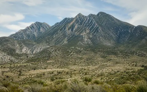
The province is broader than a line of peaks
Sierra Madre Oriental is INEGI's official physiographic name; “Eastern Sierra Madre” is an English translation, not a separately surveyed feature. INEGI defines a physiographic province as a large, geologically coherent landscape with its own morphology. The mapped province used on this page comprises, northwest to southeast, Serranía del Burro, Sierras y Llanuras Coahuilenses, Sierra de La Paila, Pliegues Saltillo–Parras, Sierras Transversales, Gran Sierra Plegada, Sierras y Llanuras Occidentales and Carso Huasteco. It includes mountain fronts, piedmont slopes and intermontane lowlands as well as high ridges. (INEGI physiographic mapping programme; Salinas-Rodríguez and others, 2022)
This scope reaches from northern Coahuila near the Río Bravo through sectors of Nuevo León, Tamaulipas, San Luis Potosí, Querétaro, Hidalgo, Puebla and Veracruz, with official northern subprovinces also entering small parts of Durango and Zacatecas. The Gulf Coastal Plain lies to the east; the Mesa Central, Mexican Plateau basins and Chihuahuan Desert margin lie mainly to the west. Southward, folded terrain is partly buried or cut across by the younger Trans-Mexican Volcanic Belt. Names such as Sierra del Burro, Sierra Gorda and Sierra de Cucharas identify local sectors; they are not aliases for the full province. (Servicio Geológico Mexicano)
Published dimensions differ because authors draw different features. A structural study restricts the Sierra Madre Oriental to a fold-and-thrust belt more than 800 km long and 80–100 km wide. Servicio Geológico Mexicano instead describes a looser orographic chain about 1,300 km long, 50 km wide on average and 2,200 m in mean elevation, continuing through Veracruz and into Oaxaca; it separately calls the Sierra Madre de Oaxaca a southern extension. A 2017 climate study used a still smaller CONABIO geomorphological polygon: approximately 720 km long, up to 160 km wide, between 19°44′09″–25°44′44″ N and 97°23′50″–102°15′15″ W. Those coordinates describe that study area, not the full INEGI province and not a point coordinate for the range. (Eguiluz de Antuñano and others, 2000; Servicio Geológico Mexicano; Suárez-Mota and others, 2017)
Folded ridges separated by piedmonts, plains and valleys
The INEGI-based polygon covers 22,015,151 hectares (about 220,152 km²). In its mapped landform inventory, mountains account for 54% of the province, piedmont slopes or bajadas 20%, plains 17%, valleys 3%, rolling hill country 2% and canyons 1%; small plateau areas and rounding account for the balance. This distribution explains why a province-area figure is much larger than length multiplied by the 80–100 km width of the narrow structural front. (Salinas-Rodríguez and others, 2022)
The same polygon analysis reports a mean elevation of 1,313 m above sea level, a minimum of 119 m on the eastern side of Sierra del Abra Tanchipa in San Luis Potosí, and a maximum of 3,709 m at Cerro el Potosí in Nuevo León. These are elevation statistics for the mapped province, not relief measured from one mountain base. INEGI's 2023 Nuevo León summary rounds Cerro el Potosí to 3,700 m at 24°52′16″ N, 100°13′59″ W; the small difference reflects source resolution and rounding rather than a changing summit. (INEGI, Aspectos geográficos de Nuevo León, 2023)
Ridge direction follows structure rather than a single compass bearing. The belt is broadly northwest–southeast, turns through the east–west Saltillo–Parras sector, then bends around the Monterrey salient before resuming a north-northwest trend toward Zongolica. Resistant carbonate beds commonly support narrow crests and cliff bands; shale-rich intervals and alluvium underlie lower slopes and valleys. In the humid Carso Huasteco, dissolution of limestone produces dolines (closed sinkhole depressions), caves and springs, while rivers cut transverse gorges through the structural grain.
Marine strata shortened above weak layers
The visible belt is dominated by Mesozoic sedimentary successions—especially limestone and other carbonate rock, with shale, sandstone and evaporites—laid down across marine platforms, basins and their margins before uplift. During development of the Mexican orogen, compression folded these strata and displaced packages of rock northeastward on thrust faults. “Thin-skinned” means that much of this shortening was detached within the sedimentary cover instead of deforming the crystalline basement everywhere. (Eguiluz de Antuñano and others, 2000)
Inherited basin geometry and rock type controlled the result. Oxfordian evaporites in the Central Mexico Basin and Cretaceous evaporites on the Valles–San Luis Potosí Platform formed weak detachment horizons. Balanced cross-sections in the structural synthesis indicate less than 35% shortening where evaporites are present and more than 40% where they are absent; these are section-based tectonic estimates, not a percentage shrinkage for the modern physiographic province. The five structural sectors therefore differ in fold shape, fault emergence and trend.
“Laramide” is useful shorthand but not a single instant. A later review of the wider Mexican fold-and-thrust system synthesizes central-Mexico shortening pulses at approximately 93–80, 75–64 and 55–43 million years ago, progressively affecting rocks farther east. Those intervals apply to the reviewed central Mexican orogen, not uniformly to every subprovince. Erosion subsequently removed softer strata, exposed fold limbs and deepened gorges; groundwater solution continues to enlarge karst pathways today. (Fitz-Díaz and others, 2018)
Platforms and basins
Carbonate, clastic and evaporite layers accumulated in contrasting Mesozoic marine settings.
Folds and thrust sheets
Late Cretaceous–Paleogene shortening transported much of the sedimentary cover northeastward.
Erosion and solution
River incision exposes folded beds; dissolution reorganizes drainage within limestone sectors.
A divided surface network with underground shortcuts
The Sierra Madre Oriental is not one continuous watershed. CONAGUA's national layers map principal rivers at 1:250,000 and distinguish drainage regions and subregions derived from INEGI elevation data. Northern slopes contribute to Río Bravo–Conchos drainage, including the San Juan system; east-facing central sectors enter San Fernando–Soto la Marina and Pánuco drainage; southern Carso Huasteco sectors also connect to north-Veracruz rivers; and western basins in the El Salado region are endorheic, meaning their surface water terminates inland. (CONAGUA hydrographic layers)
A federal assessment of the central Sierra Madre Oriental—not the whole physiographic province—mapped 74% of its study area in the Pánuco hydrological region, 13% in San Fernando–Soto la Marina, 10% in northern Veracruz drainage and 4% in El Salado. Within the Pánuco system, the Santa María–Tampaón and Moctezuma corridors cut across or along folded sectors before water reaches the Gulf lowlands. These basin shares must remain attached to the central assessment boundary. (CONANP, Central Sierra Madre Oriental assessment, 2013)
Surface divides can be misleading in limestone. A 2013 hydrogeochemical study sampled the Valles–San Luis Potosí Platform during August 2008 and modelled four west–east sections in the Huasteca Potosina. It distinguished local, intermediate and regional groundwater flow; modelled regional flow generally moves eastward, while dissolution of calcite, dolomite and gypsum and mixing between flow paths alter spring-water chemistry. The result demonstrates hydraulic connections in that central karst sector, not beneath every ridge in the full range. (Morán-Ramírez and others, 2013)
Latitude, elevation and slope exposure prevent one range climate
Gulf-facing slopes receive trade-wind moisture, while western sectors lie nearer the drier Mexican interior; elevation cools the highest ridges and the northern subprovinces experience stronger continental and winter-frontal influence. A province-wide synthesis groups mean-temperature conditions into warm 22–26 °C terrain on the eastern slope, a widespread semi-warm 18–22 °C zone, fragmented temperate 12–18 °C uplands and semi-cold 5–12 °C conditions confined to the highest summits. These are regional climate classes, not temperatures at a single station or a forecast. (Salinas-Rodríguez and others, 2022)
The range-scale contrast is more complex than a uniform “wet east, dry west” rule. The 2017 analysis combined 19 climate variables with elevation, slope and aspect at 1 km² resolution for its narrower 720 km study polygon. It found 277 statistically distinct climate domains and grouped them into five larger regions. That result captures sharp local variation but cannot be extended north of the study's 25°44′44″ N boundary without new analysis. (Suárez-Mota and others, 2017)
Rainfall processes also vary seasonally: tropical easterly flow and cyclones influence the Gulf side in the warm season, while winter nortes bring cold air, low cloud and precipitation to exposed eastern slopes. Orographic lifting—air cooling as it rises over terrain—helps explain humid belts on some windward slopes, but gaps, curved ridges and valley orientation allow moisture to penetrate unevenly. Runoff and sediment movement are consequently episodic in drier northern and western sectors, whereas humid limestone districts sustain substantial spring discharge.
Eastern margin of Mexico's interior highlands
The eastern front descends toward Tamaulipas and Veracruz lowlands, but foothills and isolated ridges make the Gulf Coastal Plain boundary irregular. Westward, the province interlocks with high basins and the Mesa Central rather than ending at one continuous crest. The Río Moctezuma–Pánuco gorge system marks an especially strong break between northern, more arid-affiliated terrain and southern Huastecan sectors, although proposed biogeographic boundaries do not exactly match the physiographic map.
At the southern end, the Trans-Mexican Volcanic Belt crosses and partly masks the older fold belt. The Sierra Madre de Oaxaca may be described as a southward orographic continuation, but it is not one of the eight INEGI subprovinces used for this page. Across the interior, the separate Sierra Madre Occidental is a much broader volcanic highland; the shared “Sierra Madre” name does not imply matching geology or a single continuous range.
Data sources and publications
- Instituto Nacional de Estadística y Geografía (INEGI). Geología y Fisiografía, accessed 30 August 2026. Official physiographic framework, province and subprovince concepts, mapping scales and national data availability.
- Salinas-Rodríguez, M. M., and others. “Diversidad de plantas vasculares de la Provincia Fisiográfica de la Sierra Madre Oriental, México.” Botanical Sciences 100(2), 2022, 469–492. INEGI-based physiographic polygon, eight subprovinces, 22,015,151 ha area, landform shares, 119–3,709 m elevation interval, 1,313 m mean elevation and regional thermal classes.
- Instituto Nacional de Estadística y Geografía (INEGI). Aspectos geográficos de Nuevo León: Compendio 2023, table 1.3. Cerro el Potosí coordinate and elevation rounded to 3,700 m in the 12 May 2023 geographic-name catalogue extract.
- Servicio Geológico Mexicano. Volcanes de México, accessed 30 August 2026. Alternate orographic dimensions, northwest–southeast orientation, local range names and Sierra Madre de Oaxaca continuation; its 1,300 km scope is kept separate from the INEGI polygon and geological belt.
- Eguiluz de Antuñano, S., Aranda-García, M., and Marrett, R. “Tectónica de la Sierra Madre Oriental, México.” Boletín de la Sociedad Geológica Mexicana 53(1), 2000, 1–26. More-than-800-km by 80–100-km structural scope, five structural sectors, Mesozoic sedimentary cover, evaporite detachments, northeastward transport and balanced-section shortening estimates.
- Fitz-Díaz, E., Lawton, T. F., Juárez-Arriaga, E., and Chávez-Cabello, G. “The Cretaceous–Paleogene Mexican orogen: Structure, basin development, magmatism and tectonics.” Earth-Science Reviews 183, 2018, 56–84. Wider-orogen scope, sedimentary assemblages, detachment controls and 93–80, 75–64 and 55–43 Ma central-Mexico deformation synthesis.
- Comisión Nacional del Agua (CONAGUA). Contexto hidrográfico map-service layers, accessed 30 August 2026. Principal rivers at 1:250,000 and national hydrological-region and subregion metadata; subregions are derived from INEGI elevation models at 1:250,000.
- Comisión Nacional de Áreas Naturales Protegidas (CONANP). Región Central de la Sierra Madre Oriental, 2013. Pánuco, San Fernando–Soto la Marina, northern Veracruz and El Salado basin shares for the central assessment boundary.
- Morán-Ramírez, J., Ramos-Leal, J. A., López-Álvarez, B., Carranco-Lozada, S., and Santacruz-De León, G. “Comportamiento hidrogeoquímico de flujos subterráneos en acuíferos cársticos fracturados, aplicando modelación inversa: Caso Huasteca Potosina.” Boletín de la Sociedad Geológica Mexicana 65(1), 2013, 71–82. August 2008 sampling, four modelled west–east sections, groundwater-flow scales, hydraulic connectivity and carbonate–evaporite dissolution.
- Suárez-Mota, M. E., Villaseñor, J. L., and López-Mata, L. “Dominios climáticos de la Sierra Madre Oriental y su relación con la diversidad florística.” Revista Mexicana de Biodiversidad 88, 2017, 224–233. Narrower CONABIO polygon coordinates and dimensions, 1 km² analysis of 19 climate variables plus terrain, 277 domains and five aggregated climate regions.