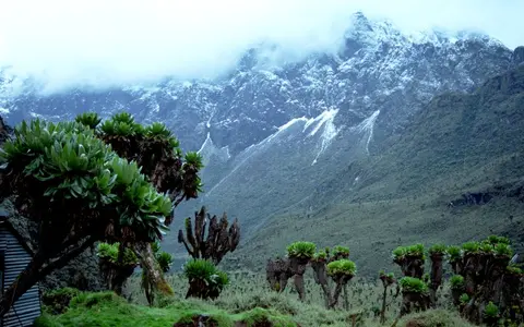

A physical range across a political border
Rwenzori Mountains is the spelling used by Uganda Wildlife Authority and UNESCO. Ruwenzori is an established older spelling, while “Mountains of the Moon” is a historical and cultural label, not a separately surveyed landform. This page covers the physical mountain range. It does not use the 99,600-hectare Rwenzori Mountains National Park in Uganda, the adjoining Virunga National Park in DR Congo, or either park boundary as the range boundary. (Uganda Wildlife Authority; UNESCO World Heritage Centre)
Published dimensions depend on which foothills are included. Uganda Wildlife Authority describes a 120 km by 65 km range; a 2012 landscape model treats the compact high-alpine chain as about 80 km by 40 km. These are generalized bounding rectangles for different scopes, not surveyed length and width measurements. The range trends roughly north–south between the Semliki trough on the west and the western Ugandan plateau on the east, with the Lake Edward–George rift basins to the south and southeast and the Lake Albert basin to the north. (Uganda Wildlife Authority; Kaufmann and Romanov, 2012)
A commonly cited coordinate envelope of 0°10′–0°30′ N, 29°50′–30°00′ E comes from a glacier study and refers to the central glacierized Rwenzori, not the whole 120-km range. UNESCO's mapped property point, 0°13′25″ N, 29°55′27″ E, likewise locates the Ugandan national park rather than a range centroid. (Taylor and others, 2006; UNESCO property map)
Six massifs above the rift floor
The high centre consists of Mount Stanley, Mount Speke, Mount Baker, Mount Emin, Mount Gessi, and Mount Luigi di Savoia, each a massif—a cluster of peaks and ridges—rather than a single summit. Uganda Wildlife Authority lists their highest points at 5,109, 4,890, 4,843, 4,797, 4,715, and 4,627 metres respectively. Margherita Peak is the highest summit of Mount Stanley and of the range. The six-massif list describes the high Rwenzori; it is not a count of every mountain or ridge in the broader foothills. (Uganda Wildlife Authority park brochure)
Relief is the height difference within a landscape, not summit elevation. On the western side, Margherita stands more than 4,000 m above the nearby Semliki Valley over a short horizontal distance. North and south of the central block, elevations fall abruptly and most peaks are below 2,000–3,000 m; eastward, a more complex fault array produces a broader, more gradual descent. (Ring, 2008)
Deep transverse valleys divide the massifs. Cirques—amphitheatre-shaped glacier source hollows—cut the summit zone; U-shaped upper valleys, hanging tributaries, rock steps, moraines, and lake basins record former ice. Below about 3,000 m, active rivers occupy narrow valleys and continue to deepen and transport material from the range. (Marschall and others, 2026)
Old basement, multiphase Cenozoic rise
The range is built mainly from Precambrian metamorphic basement: Archaean gneisses, Proterozoic schists, and Palaeoproterozoic amphibolites. These rock ages describe when the source crust formed or was metamorphosed; they do not date the modern relief. The volcanic fields east of the range and the Virunga volcanoes farther south are geologically separate. (Marschall and others, 2026)
The Rwenzori lie where the Albertine Rift changes between the Lake Albert and Lake Edward–George segments. Normal faults—faults on which the hanging wall moves down relative to the footwall—bound and dissect the uplifted basement. The steep western Bwamba border fault accounts for the sharp Semliki-facing escarpment. On the east, the Ruimi–Wasa and Nyamwamba faults form part of a wider fault array; faults within the central block show that the range is not one rigid, uniformly tilted horst. (Ring, 2008)
No single “formation age” adequately describes this topography. Low-temperature thermochronology and river-profile modelling published in 2020 infer uplift-related exhumation beginning in the Oligocene and possibly the Eocene, followed by another important phase in the late Miocene–Pliocene. Older models emphasized much younger, rapid uplift and glacial unloading. The accepted physical picture is therefore multiphase fault-block uplift modified by erosion, while the timing and relative contribution of fault flexure, deeper geodynamics, and erosion-driven isostatic rebound remain research questions. (Jess and others, 2020; Ring, 2008)
Precambrian metamorphic rock
The ancient crystalline core is much older than the rift relief raised from it.
Asymmetric fault block
A sharp western escarpment contrasts with a broader, faulted eastern descent.
Rivers, ice, and slopes
Fluvial incision, glacial erosion, weathering, and mass movement continue to reshape uplifted rock.
Large former glaciers, 0.38 km² mapped in 2022
During the global Last Glacial Maximum, ice from the central peaks filled major valleys. Beryllium-10 exposure dating indicates that glaciers had reached their maximum positions by roughly 28,000 years ago; Bujuku and Mubuku ice joined in the lower Mubuku valley and terminated near 2,000 m above sea level. Retreat from those outer limits began by about 21,500 years ago. These dates come from moraine boulders and describe late-Pleistocene ice margins, not the ages of the valleys themselves. (Jackson and others, 2019; Jackson and others, 2020)
The latest comprehensive range-wide mapping used high-resolution PlanetScope images from January 2022. Manual minimum, primary, and maximum outlines were drawn to account for shade, seasonal snow, and uncertain pixels. The primary estimate is 0.38 km² of glacier area, with uncertainty within 12.5%. Mount Stanley held 92% of that mapped area; only small remnants survived on Mount Speke and Mount Baker. The measurement is plan-view area, not ice volume. (Hinzmann and others, 2024; PANGAEA glacier outlines)
The same study compares the 2022 result with an estimated 6.51 km² in 1906, a reduction of more than 90%. That long comparison joins historical mapping and modern satellite interpretation, so the endpoints are less methodologically uniform than a single modern inventory. Modern ice is a summit-zone component: the wider river network is sustained chiefly by abundant precipitation and catchment storage, not by glacier melt alone. (Rwimi I environmental assessment)
One Nile-basin source area, several routes
Short, steep rivers radiate from the massifs, but the political Uganda–DR Congo border is not a Nile–Congo watershed here. An official basin assessment places all rivers originating in the Rwenzori within the connected Semliki–Lake Albert–Nile system. On the Ugandan east and southeast, the Rwimi, Mubuku, and Nyamwamba descend toward Lake George, while the Nyamugasani reaches Lake Edward. Lake George drains through the Kazinga Channel to Lake Edward; Lake Edward's outlet, the Semliki River, runs north along the western foot of the range to Lake Albert. Water leaves Lake Albert as the Albert Nile. (Albertine-region basin assessment)
On the western slopes in DR Congo, rivers including the Lume, Taliha, and Butahu descend more directly to the Semliki corridor. On the north, other streams reach the Lake Albert basin. Small lakes such as Bujuku, Mahoma, and the Kitandara lakes occupy glacially excavated or moraine-influenced basins, and upper-valley wetlands slow and store part of the precipitation before it enters the steep channels. The lakes differ in origin and outlet arrangement, so “glacial lake” describes a landform history, not necessarily present contact with a glacier. (Uganda Wildlife Authority park map; Jackson and others, 2019)
Rainfall, steep slopes, fractured rock, and loose valley sediment produce rapid runoff and sediment movement. A 2016 field inventory mapped 371 landslides across three Ugandan study areas totalling 114 km²; more than 95% of the slides with an attributed trigger were reported as rainfall-triggered. That sample demonstrates process, not a range-wide landslide total, and the authors could not derive a rainfall threshold because event and gauge records were sparse. (Jacobs and others, 2016)
George–Edward route
Several major rivers cross the Ugandan piedmont to Lakes George or Edward before joining the Semliki.
Semliki–Albert route
Western tributaries descend toward the Semliki; northern drainage reaches the Lake Albert basin.
Equatorial seasonality modified by relief
Near-equatorial latitude keeps the annual temperature range small at a given elevation, while daytime–night-time variation is larger and temperature decreases strongly upslope. Seasonal movement of the tropical rain belt helps produce wetter periods broadly in March–May and August–December, but rain and cloud can occur in nominally drier months. Orographic uplift—air forced upward by terrain—cools moist air and redistributes rain among slopes, elevations, and valleys. (Uganda Wildlife Authority park brochure; Taylor and others, 2006)
Uganda Wildlife Authority observations for 2012–2015, reported in a peer-reviewed study, give mean annual rainfall of 1,570 ± 334 mm at 1,760 m and 1,806 ± 322 mm at 4,230 m along an eastern elevational transect. These are short-period site measurements, not climate normals for the entire range. They show why an unqualified single annual-rainfall value would be misleading. (Okello and others, 2022)
Gauge coverage remains sparse in this steep terrain. A 2022 evaluation used 11 stations, generally with only about 2.5 years of observations between 2011 and 2016, and found large differences among ERA5, IMERG, and convection-permitting model rainfall totals. The study preferred IMERG for totals and the high-resolution model for rainfall-intensity distributions, while cautioning against taking any gridded product as an observed mountain climatology. Persistent cloud, saturated soils, bogs, and frequent rain are real highland features, but their magnitude varies sharply over short distances. (Nakulopa and others, 2022)
A high block between linked rift basins
The Rwenzori occupy the structural step between the Lake Albert basin to the north and the Lake Edward–George basins to the south. The Semliki valley curves along the west and northwest, separating the range from uplands farther into DR Congo. Eastward, the mountain front opens toward the Lake George plain and the western Ugandan plateau. This arrangement explains both the asymmetric relief and the different routes by which runoff reaches the same Nile drainage network.
Farther south, the Albertine Rift continues into the Virunga Mountains. The two ranges are neighbors, not one landform: the Rwenzori are uplifted crystalline basement, whereas the Virunga are a volcanic chain. For wider comparison, use the Mountain Hub; to follow the connected drainage beyond Lake Albert, use the Nile record.
Data sources and publications
- Uganda Wildlife Authority. Rwenzori Mountains, accessed 30 August 2026. Current official spelling, broad 120 × 65 km dimensions, 5,109-m summit elevation, and distinction between range and park.
- Uganda Wildlife Authority. Rwenzori Mountains National Park, park brochure, accessed 30 August 2026. Six-massif elevations and seasonal rainfall description.
- UNESCO World Heritage Centre. Rwenzori Mountains National Park and property map, accessed 30 August 2026. Park-bounded area, mapped property point, transboundary setting, and 5,109-m summit elevation.
- Ring, U. Extreme uplift of the Rwenzori Mountains in the East African Rift, Uganda: Structural framework and possible role of glaciations. Tectonics 27 (2008), TC4018. Fault architecture, west–east relief asymmetry, and uplift hypotheses.
- Jess, S., Koehn, D., Fox, M., Enkelmann, E., Sachau, T., and Aanyu, K. Paleogene initiation of the Western Branch of the East African Rift: The uplift history of the Rwenzori Mountains, Western Uganda. Earth and Planetary Science Letters 552 (2020), 116593. Multiphase uplift and exhumation chronology.
- Kaufmann, G., and Romanov, D. Landscape evolution and glaciation of the Rwenzori Mountains, Uganda: Insights from numerical modeling. Geomorphology 138 (2012), 263–275. Approximately 80 × 40 km high-chain model scope and interactions among uplift, rivers, slopes, and ice.
- Jackson, M. S., and others. High-latitude warming initiated the onset of the last deglaciation in the tropics. Science Advances 5 (2019), eaaw2610; and Glacial fluctuations in tropical Africa during the last glacial termination. Quaternary Science Reviews 243 (2020), 106455. Moraine exposure ages, maximum ice positions, and deglaciation timing.
- Hinzmann, A., Mölg, T., Braun, M. H., Cullen, N. J., Hardy, D. R., Kaser, G., and Prinz, R. Tropical glacier loss in East Africa: recent areal extents on Kilimanjaro, Mount Kenya, and in the Rwenzori Range from high-resolution remote sensing data. Environmental Research: Climate 3 (2024), 011003; with PANGAEA dataset. January 2022 glacier area, mapping method, uncertainty, massif shares, and historical comparison.
- Eco Power Holdings Limited. Environmental and Social Impact Assessment Report for the Proposed Rwimi I Small Hydro Power Project. Report E4444, volume 6, 2013. Named east- and west-slope rivers and their connection through the Semliki to Lake Albert and the White Nile.
- Jacobs, L., Dewitte, O., Poesen, J., Maes, J., Mertens, K., Sekajugo, J., and Kervyn, M. Landslide characteristics and spatial distribution in the Rwenzori Mountains, Uganda. Journal of African Earth Sciences 134 (2017), 917–930. Field-inventory scope, lithologic controls, and reported triggers.
- Okello, J., Bauters, M., Verbeeck, H., Kasenene, J., and Boeckx, P. Response of Afromontane soil organic carbon, nitrogen, and phosphorus to in situ experimental warming along an elevational gradient. Frontiers in Soil Science 2 (2022). UWA 2012–2015 rainfall observations at 1,760 and 4,230 m.
- Nakulopa, F., and others. Evaluation of High-Resolution Precipitation Products over the Rwenzori Mountains (Uganda). Journal of Hydrometeorology 23 (2022), 747–768. Station record scope, rainfall-product limitations, and terrain effects.
- Taylor, R. G., Mileham, L., Tindimugaya, C., Majugu, A., Muwanga, A., and Nakileza, B. Recent glacial recession in the Rwenzori Mountains of East Africa due to rising air temperature. Geophysical Research Letters 33 (2006), L10402. Central glacier-study coordinates, historical glacier mapping, and equatorial temperature seasonality.
- Marschall, H., and others. Climate Change and Rockfall Activity in the Rwenzori Mountains, Uganda. Earth Surface Processes and Landforms (2026). Basement lithologies, fault lineaments, high-elevation landforms, and modern slope-process context.