What this page includes
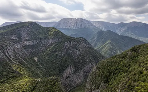
Pindus and Pindos are English transliterations of the same Greek name, Πίνδος. This page uses Pindus Mountains for the physical chain: the border highlands around Grammos, the northern Pindus massifs of Smolikas, Tymfi, Vasilitsa and Lygkos, then the southeastward continuation through Lakmos and Athamanika (Tzoumerka) to the Agrafa highlands of central Greece. The chain merges northward into southern Albanian highlands and the wider Dinaride–Hellenide system; the political border does not create a topographic break.
The endpoints are transitional. The published figure of about 230 km long and 70 km wide is retained only as an indicative Greek-range scale because its issuing management agency provides neither endpoints nor a boundary polygon. This record does not extend “Pindus” across every Hellenide ridge in the Peloponnese, and it does not use the boundary of Northern Pindos National Park as the boundary of the range. No authoritative natural area or centroid was found, so an area total and single coordinate are deliberately omitted. (Northern Pindos National Park: mountain complexes and climate)
Pindos Zone has a different meaning. It is a named deep-marine unit of the External Hellenides, with a Triassic-to-Eocene basin succession capped by flysch. The physical mountains cross more than that one tectonic unit and include large northern ophiolite bodies. Treating the range and the zone as synonyms would put the same geology beneath limestone Tymfi and ophiolitic Smolikas, which the mapped rock distribution does not support. (Ferriere, Jolivet and Chanier, 2024; Northern Pindos National Park geology)
Massifs between Epirus and the eastern basins
The highest northern sector is a cluster rather than a continuous wall. Smolikas rises east of the Aoos corridor; limestone Tymfi stands to the southwest across the Aoos valley; Vasilitsa and Lygkos continue the high ground southeast toward Metsovo. The park authority lists 2,637 m for Smolikas, 2,497 m for Tymfi, 2,249 m for Vasilitsa and 2,177 m for Lygkos. These are published summit elevations above sea level, but the source does not identify a vertical datum or mapping edition, so the metre values are not converted or given extra precision. (Northern Pindos National Park Management Agency)
South of the Metsovo pass area, Lakmos and Athamanika continue the northwest–southeast grain between the Arachthos side and the upper Acheloos and Pinios catchments. Agrafa forms the southern highland sector used in this record. Passes, structural basins and rivers interrupt every proposed axial crest, while western slopes descend into Epirus and eastern slopes face the basins of western Macedonia and Thessaly. Administrative regions cross this relief and are orientation aids, not physical boundaries.
Stacked marine basins and oceanic-rock sheets
The Pindus is part of the Hellenides, an Alpine-type orogen assembled in stages. A 2024 synthesis identifies Jurassic obduction—the emplacement of slices of Tethyan oceanic lithosphere over a continental margin—followed by Eocene collision between Adria to the southwest and European-affinity crust to the northeast. Miocene and younger extension then reworked the inherited thrust belt and helped form or enlarge neighboring basins. The present relief is therefore younger than many of its rocks and records both compression and later faulting. (Ferriere, Jolivet and Chanier, 2024)
The northern range makes the contrast visible. Ophiolitic rocks dominate Smolikas, Vasilitsa, Lygkos, Mavrovouni and nearby massifs, whereas Tymfi, Trapezitsa and Mitsikeli are predominantly limestone. An ophiolite is a tectonically emplaced association of former oceanic mantle and crust; exposed peridotite and its altered form, serpentinite, account for many dark, blocky slopes. Limestone belongs to former marine sedimentary successions. Flysch—interbedded sand-, silt- and mud-rich sediment deposited during mountain building—commonly forms more erodible belts between resistant units. (Northern Pindos National Park geology)
Northwest–southeast nappes
Nappes are large transported sheets of rock. Their stacking established the regional alignment later sharpened by erosion.
Ophiolite beside limestone
Smolikas–Vasilitsa oceanic-rock terrain differs fundamentally from the carbonate cliffs and plateaus of Tymfi.
Faulting, incision and slope failure
Extension and river downcutting increased local relief; weaker flysch belts are more readily weathered and destabilized.
Bedrock controls cliffs, hollows and valleys
Water follows joints and bedding planes in limestone, dissolving the rock and creating karst. On the plateaus this produces enclosed dolines, larger flat-floored depressions, caves and shafts; at the margins it concentrates flow at springs. Vikos and Aoos gorges cut the northern carbonate terrain, while resistant limestone remains in steep walls above narrower valley floors. The protected-area geology account also maps flysch between limestone and ophiolitic formations in Central and Eastern Zagori. (Northern Pindos National Park, Discovering Pindos)
Ophiolite does not make the same dissolution landscape. Peridotite and serpentinite tend to form rocky ridges, debris-covered slopes and thin, chemically distinctive soils. Flysch more readily weathers into rounded slopes and supplies sediment to streams. The repetition of resistant and weak belts helps explain why the Pindus consists of separate massifs and deeply cut corridors rather than a uniform ridge.
Headwaters cross the mountain grain
The range is a source region for several basins, but not one simple two-sea divide. The Aoos begins in the Greek Pindus and runs northwest through Albania as the Vjosa to the Adriatic; IUCN gives about 272 km from source to coast for the whole transboundary river, not for its Greek reach. Northern Pindus streams also feed the Arachthos, Aliakmon, Sarantaporo, Voidomatis and Arkoudorema systems. (IUCN, 2022; Northern Pindos National Park Management Agency)
In central Pindus, the watershed separates tributaries of the Acheloos from those of the Pinios. The Greek water authority maps the 7,531 km² Acheloos river basin with Lakmos on its northwest boundary and Pindus, Tymfristos, Oxia and Panaitoliko on the east. That number describes the regulated river-basin unit EL0415, not the area of the mountains. Its 2018 summary also records that the 161 km² upper Tavropos sub-basin is hydrologically part of the Acheloos but managed with the Pinios district because its water is diverted toward Thessaly—an example of why hydrological and administrative boundaries must be kept separate. (Greek Special Secretariat for Water, 2018)
Some streams follow softer belts parallel to the range; others cut across structure through gorges. In limestone, part of the flow can sink into fractures and conduits and reappear at springs, so a surface contour does not always delimit the whole groundwater catchment. Rain and snowmelt raise cool-season and spring runoff, while the Mediterranean summer minimum reduces surface flow; regulation and inter-basin transfers alter that natural timing in several headwater systems.
A wet western barrier with a dry summer
Westerly and southwesterly flows bring Mediterranean moisture toward western Greece. Forced ascent over the Pindus cools the air and favors rain and high-elevation snow; descending air and reduced moisture contribute to generally drier conditions east of the main highlands. The contrast is not uniform: storm track, elevation, slope aspect and enclosed basins produce sharp local differences. A 2026 mountain-snow study describes the range as a climatic divide between the wetter western and drier eastern mainland. (Alexopoulos and others, 2026)
Measured central-Pindus data show the seasonal concentration. Stefanidis and Stathis analysed complete monthly records from nine gauges for 1961–2016. Across their four modelled catchments, reconstructed mean annual rainfall ranged from about 816 to 1,732 mm; 35% of annual rain fell in winter, 32% in autumn, 24% in spring and 9% in summer. These are gauge-supported, kriged ranges for the Klinovitikos, Aspropotamos, Korpos and Portaikos catchments—not a normal for the whole Pindus or a summit measurement. Most station trends were not statistically significant, so this page does not convert them into a range-wide rainfall trend. (Stefanidis and Stathis, 2018)
Snow cover varies strongly from year to year and with altitude. A 2026 reconstruction using satellite observations and modelled gap filling for ten Greek massifs found a 57.5% ± 1.4% decline at the end of 1984–2025 relative to that period's mean, with sustained seasonal warming the main driver. Because the study pools selected high massifs across Greece rather than delineating the Pindus as one unit, the figure is evidence of the modern Greek-mountain snow trend, not a measured percentage loss for the entire range. (Alexopoulos and others, 2026)
Repeated Pleistocene ice, not one ice cap
Cirques, moraines, glacially widened valleys and relict rock glaciers in the high northern massifs record several cold stages. Mapping and uranium-series dating on secondary calcite in glacial deposits led Hughes and colleagues to define three regional stages. The oldest and most extensive recorded glaciation, the Skamnellian Stage correlated with Marine Isotope Stage 12, predates 350,000 years before present and produced valley glaciers and ice fields. Later Vlasian ice reached mid-valley positions, while Tymphian ice left smaller cirque-glacier moraines and rock-glacier landforms. (Hughes and others, 2006)
Those stages are a chronostratigraphy built principally from Mount Tymfi and correlated with the long Lake Ioannina record. They do not imply that every Pindus massif carried ice of the same size or at exactly the same time. Bedrock, elevation, exposure and snowfall controlled each local glacier, and later rivers and slope processes reworked parts of the deposits.
Between the Dinarides and central Greece
The northwest–southeast Hellenide structural grain continues northward toward the Dinaric Alps, but “Dinaric” and “Pindus” are not interchangeable range labels and their transition is not a surveyed line. East of the Pindus lie the basins and ranges of western Macedonia and Thessaly; westward, rivers descend across Epirus toward the Ionian margin; southward, the Agrafa sector grades into the mountains of central Greece.
The most useful way to read the range is therefore as a linked physical system: tectonic sheets establish the grain, bedrock controls karst and slope form, rivers breach or follow the grain, and topography redistributes moisture and snow. Compare it with other systems in the mountain hub while keeping the mountain range distinct from the Pindos geologic zone, protected-area boundaries, river-basin districts and administrative regions.
Data sources and publications
- Ferriere, J., Jolivet, L., and Chanier, F. “From subduction to collision and subduction again, the drivers of crustal-scale deformation in the Hellenides-Aegean region,” Comptes Rendus Géoscience 356(S2) (2024), 163–205. Hellenide tectonic framework, Jurassic obduction, Eocene collision, Miocene extension, and the specific meaning of the Pindos Zone.
- Northern Pindos National Park Management Agency. Mountainous Complexes – Climate (accessed 30 August 2026). Published 230 km by 70 km range scale, named northern massifs, summit elevations, drainage and local elevation-dependent climate. The page supplies no range polygon, measurement method, vertical datum or survey edition.
- Northern Pindos National Park Management Agency. Geology and Discovering Pindos (2017; accessed 30 August 2026). Distribution of northern limestone, ophiolite and flysch terrain and examples of karst relief.
- Hughes, P. D., Woodward, J. C., Gibbard, P. L., Macklin, M. G., Gilmour, M. A., and Smith, G. R. “The Glacial History of the Pindus Mountains, Greece,” The Journal of Geology 114(4) (2006), 413–434. Mapped northern glacial sequence, uranium-series dating and the Skamnellian, Vlasian and Tymphian stages.
- Stefanidis, S., and Stathis, D. “Spatial and Temporal Rainfall Variability over the Mountainous Central Pindus (Greece),” Climate 6(3) (2018), article 75. Nine-gauge 1961–2016 record, seasonal shares and catchment-scale kriged rainfall ranges.
- Hellenic Republic, Ministry of Environment, Energy and Climate Change, Special Secretariat for Water. Management Plan of the River Basins of Epirus River Basin District: Summary (September 2013). Official Aoos and Arachthos river-basin districts and mapped water bodies.
- Hellenic Republic, Ministry of Environment & Energy, Special Secretariat for Water. 1st Update of River Basin Management Plans: Western Sterea Ellada (EL04), Summary, last revised 3 April 2018. Acheloos basin area and limits and the Tavropos hydrological/management-boundary distinction.
- International Union for Conservation of Nature. “World Rivers Day 2022: Protecting the free-flowing Aoos–Vjosa River in Greece and Albania,” 7 October 2022. Transboundary name, Greek Pindus source and approximately 272 km source-to-Adriatic course.
- Alexopoulos, K., Willis, I. C., Pritchard, H. D., Kyros, G., Kotroni, V., and Lagouvardos, K. “Greek mountain snow cover halved in past four decades due to regional warming,” The Cryosphere 20 (2026), 2209–2236. Pindus climate-divide context and 1984–2025 snow-cover reconstruction for ten selected Greek massifs; not a range-wide Pindus inventory.