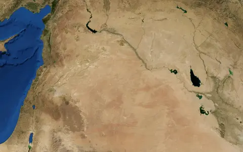

Bādiyat ash Shām, not the state of Syria
The Library of Congress uses Syrian Desert as its authorized English subject heading and records Bādiyat ash Shām, Bādiyat al-Shām, Cham Desert, and Shām Desert as variants.[1] The UK Permanent Committee on Geographical Names recommends Bādiyat ash Shām, gives Syrian Desert as the conventional English name, and also records context-dependent names including Syrian Steppe, Jordanian Steppe, Shamiyah, and Western Desert.[2] Those last names can denote national sectors or local landscapes, so this page does not treat them as exact interchangeable boundaries.
Historical and modern outlines vary. A recent scholarly synthesis uses a broad triangular frame with an apex south of Aleppo, the Euphrates along its northeast side, and a southern line from the Gulf of Aqaba toward the head of the Persian Gulf; it distinguishes the drier southern “Great Desert” from the Palmyrene “Little Desert.”[3] This atlas record focuses on the connected northern plateau and steppe across Syria, Jordan, western Iraq, and northern Saudi Arabia. It excludes the Jazira northeast of the Euphrates, does not absorb the whole Arabian Desert, and treats the An Nafud sand sea as a southern neighboring feature rather than part of the Hamad.
No source checked for this revision supplies a surveyed perimeter for that atlas scope. The former “about 500,000 km²” card therefore conflated unlike regional definitions and has been removed. Likewise, the PCGN coordinate is retained only as a searchable gazetteer point; it is not presented as the desert's natural centre.[2]
Uplands descend toward the Euphrates
Across the broad regional frame, the plateau stands about 400 m near the northern foothills and about 800 m beside the western mountain chains, then falls to roughly 30–40 m above mean sea level at the lower Euphrates escarpment.[3] These figures describe a long regional profile, not the extrema of every hill, basin, or national sector. The through-flowing Euphrates occupies a much lower corridor and separates the desert plateau from the Jazira to the northeast.
The Palmyride belt interrupts the Syrian plain. Low, steep ridges begin northeast of Damascus, pass north of Palmyra, and continue toward the Euphrates as the limestone massifs of Jebel Chaar, Jebel Abyat, Jebel Abu Rujmayn, and Jebel Bishri.[3] South and east of Palmyra the terrain becomes almost level Hamad; southwestward it meets the rough volcanic ground of al-Harra. Across Jordan the plateau includes the Azraq and Wadi Sirhan depressions, while its eastern continuation becomes Iraq's Western Desert before dropping to the Euphrates.
Badia, Hamad, harra, and qaa
Badia is the broad regional term for the desert-steppe. Hamad is more specific: open, gravel-covered limestone country. In northeastern Jordan, field descriptions distinguish that pale limestone-and-chert surface from the harra, where basalt flows, tuffs, boulder fields, incised wadis, low lava cliffs, and scree overlie the sedimentary plateau.[4] Neither word means that every part of the Syrian Desert has the same bedrock or surface cover.
A qaa is a low flat where fine, water-laid sediment ponds. Jordan Badia mapping distinguishes qaa that drain onward from those in closed basins; some limestone tracts carry angular chert pavement, whereas local gypsum crusts and fine sediment accumulate toward basin floors.[8] This is why “salt flat,” “playa,” and “wadi” should not be collapsed into one generic desert hollow.
Hamad
Open limestone country with gravel and chert pavement, crossed locally by broad wadis and shallow depressions.
Harra
Rough basalt and tuff terrain with cones, lava edges, boulder fields, and more sharply incised drainage.
Qaa
A fine-sediment flat that may drain onward or occupy a closed basin; salts can concentrate where evaporation dominates.
Old erosion surfaces, younger channel deposits
The flatness is inherited, not simply the result of modern wind planing. A regional geomorphic survey identified several erosion surfaces, some interpreted as Oligocene in origin, and linked parts of the wadi pattern to Miocene marine incursions and sediment that buried older lower channels.[5] These are stages in the development of the plateau; they are not one formation date for the Syrian Desert.
The same study separated well-drained wadi tracts from nearly level areas with little expressed drainage. It interpreted many shallow khabra depressions as products of solution in carbonate rock and wind deflation rather than tectonic subsidence, and recorded Pleistocene gravel terraces along marginal wadis.[5] Present surfaces therefore combine ancient planation, exposed marine sedimentary rocks, weathered chert and basalt, wind redistribution of fines, and episodic alluviation.
Harrat ash Shamā crosses three countries
Harrat ash Shamā (also written Harrat Ash Shaam) is a Cenozoic volcanic field extending from southern Syria across northeastern Jordan into northwestern Saudi Arabia. A 2026 U.S. Geological Survey review maps the field at about 48,000 km², making that a measurement of the volcanic province—not of the Syrian Desert.[6] Its dominant rocks are mafic, alkaline lavas: fluid basaltic eruptions built overlapping sheets, while localized vents produced scoria cones and greater volcanic relief.
The field contains smaller named tracts including Jabal ad Druze, Es Safa, the Golan Heights field, Kra, and Saudi Al Harrah. The Smithsonian catalogue describes activity beginning in the Miocene and continuing in its southeastern part during the late Pleistocene and Holocene; it dates the confirmed Kra eruptive episode to 2670 BCE ± 200 years by calibrated radiocarbon evidence.[7] That date belongs to one eruptive episode, not to all basalt in the harrat. A widely repeated 1850 CE Es Safa eruption has been rejected after retranslation of the original account.[7]
Seasonal channels reach rivers or interior lows
The Syrian Desert is not one endorheic basin. South and east of Palmyra, deep seasonal wadis trend toward the Euphrates, but runoff is discontinuous and many flows infiltrate or spread over alluvial ground before reaching the river.[3] In northeastern Jordan, mapped wadis generally flow south or southwest; much of that drainage enters the Azraq basin, while qaa elsewhere either retain water locally or pass it onward.[8] Short-lived ponding followed by evaporation leaves clay, silt, gypsum, and other salts in closed lows.
Wadi Hawran supplies a measured eastern example. A 2025 DEM-based basin study delineates about 17,945 km², extending from Jordan and Saudi Arabia into western Iraq, and places its outlet in the Euphrates south of Haditha. The mapped basin falls from about 949 m in the west to about 80 m at its eastern outlet.[9] Those area and elevation values belong to the Wadi Hawran catchment, not to the whole desert.
Groundwater likewise varies by rock unit. In the Jordan Badia, Paleozoic–Lower Cretaceous clastic and carbonate rocks form a lower aquifer complex, Upper Cretaceous–Tertiary carbonates form an upper complex, and faults, basalt flows, alluvium, and weathered zones create local pathways or barriers.[8] Springs and oases are therefore localized expressions of structure and recharge rather than evidence of a continuous shallow water table.
Winter rain weakens into a hot-desert interior
In summer, subtropical high pressure suppresses rainfall and promotes strong heating. In winter, low-pressure systems travel east through the Mediterranean; the Levantine ranges remove moisture and help create a sharp decline toward the interior.[3] The northern and northwestern Palmyrene sector is commonly classified as dry steppe (Köppen–Geiger BS), while the southern “Great Desert” is desert (BW). The regional name consequently spans a climatic transition, not one uniform hot-desert cell.[3]
The period and method matter for rainfall numbers. FAO reports 127 mm/year at Palmyra as a 42-year mean and records project-year totals of 198, 181, 27, and 71 mm in 1997–2000, a compact demonstration of year-to-year variability.[10] A separate synthesis gives 133 mm for Palmyra from the WMO 1961–1990 normal.[3] The 127 and 133 mm values use different record definitions and are retained separately rather than averaged.
A 2026 analysis of ERA5-Land reanalysis at approximately 9 km resolution places most of eastern and southeastern Syria in the BWh hot-desert class. Its 1991–2020 climatology gives typical annual precipitation below 100 mm there, coldest annual nights around −2 to −4 °C, and the hottest annual day above 44 °C.[11] These are gridded values for Syria's arid sector, not station observations or measurements for Jordan, Iraq, and Saudi Arabia. Sparse rain can still arrive in intense localized bursts, producing erosion and flash runoff without creating perennial streams.
Between Levant, Arabia, and Mesopotamia
Northward and westward, increasing winter rain grades into the Palmyrene and Levantine steppe; the change is climatic and topographic rather than an administrative line. Southward, the Hamad passes toward An Nafud and the wider Arabian Desert. The boundary is conventional, but the contrast between northern winter-rain steppe and drier southern desert remains physically useful.
Eastward, Euphrates-bound wadis and the falling plateau connect the region to the Tigris–Euphrates River System. Closed qaa and the Azraq depression show the opposite condition: local base levels with no through-flow to the sea. Reading those two drainage modes together explains why the Syrian Desert is best understood as a plateau-scale dryland mosaic rather than as one basin, one geology, or one sand sea.
Sources and measurement notes
- Library of Congress, Library of Congress Subject Headings, section S, 45th edition (2023), p. S-869. Source for the authorized English heading and listed variants; it does not define a perimeter.
- UK Permanent Committee on Geographical Names, Iraq Toponymic Factfile (May 2025), p. 13. Gives the recommended and conventional names, variants, feature type, and 32°00′N, 40°00′E gazetteer location. This page treats the coordinate as a reference point, not a centroid.
- Seland, E. H., “Climate and Environment of Palmyra and the Syrian Desert”, in Raja, R. (ed.), The Oxford Handbook of Palmyra (Oxford University Press, 2024), pp. 15–28, especially pp. 17–22. Source for the broad regional frame, Syrian plateau profile, Palmyride and Hamad spatial relationships, drainage, climate classes, rain-bearing systems, and the WMO 1961–1990 Palmyra value.
- Finlayson, B. & Betts, A., “Functional Analysis of Chipped Stone Artefacts from the Late Neolithic Site of Gabal Na'ja, Eastern Jordan”, Paléorient 16(2), 13–20 (1990). Used for the field-based distinction among Badia, limestone-and-chert Hamad, and basaltic harra, plus the Ruwayshid and Dumayta drainage context.
- Wirth, E., “Morphologische und bodenkundliche Beobachtungen in der syrisch-irakischen Wüste”, Erdkunde 12(1), 26–42 (1958). A classic regional geomorphic interpretation used for erosion surfaces, inherited wadis, Miocene burial, khabra formation, deflation, and Pleistocene terraces; its relative chronology is not converted here into one “age of the desert.”
- Sisson, T. W. & Calvert, A. T., U.S. Geological Survey, Cenozoic Distributed Volcanism of the Arabia Plate—A Review, Professional Paper 1890-J (2026). Source for the 48,000 km² Harrat ash Shamā measurement, Arabian harrat setting, composition, and long-lived intraplate volcanism.
- Smithsonian Institution Global Volcanism Program, “Harrat Ash Shaam”, Volcano Number 231001 (database record accessed 29 August 2026). Source for mapped subfields, rock types, Miocene-to-Holocene history, the Kra calibrated radiocarbon date, and rejection of the alleged 1850 eruption.
- Al-Homoud, A. S., Sunna, B. F., Allison, R. J., Higgitt, D. L. & White, K., “Regional Geologic Environs and Natural Resources of Badia Sector, Jordan”, Environmental Geology 36, 18–26 (1998). Source for source-defined Jordan Badia areas, sedimentary and basalt stratigraphy, aquifer complexes, qaa terminology, and northeast-Jordan drainage directions.
- Awad, A. Y., Al-Qayyssi, K. A., Khalaf, A. M. & Omer, O. N., “Assessment of Water Erosion in the Houran Valley Using the Gavrilovic Erosion Potential Method and Geomatics Techniques”, International Journal of Design & Nature and Ecodynamics 20(12), 2849–2858 (2025). Source for the DEM-defined 17,945 km² Wadi Hawran basin, 949–80 m profile, transboundary headwaters, and Euphrates outlet.
- Serra, G., Williamson, D. & Batello, C., FAO, “The Rangelands of the Syrian Arab Republic”, in From Indifference to Awareness: Encountering Biodiversity in the Semi-arid Rangelands of the Syrian Arab Republic (Rome, 2003). Source for the 42-year 127 mm/year Palmyra mean and 1997–2000 project rainfall; the unstated station-record endpoints are not inferred.
- Mabrouk, M. B. et al., “Climate Change-Induced Variabilities and Most Recent Normal in Climate Extremes Using ERA5-Land Reanalysis Data in Syria from 1950 to 2024”, Climate Dynamics (2026). Source for the approximately 9 km ERA5-Land method, Köppen classes, 1991–2020 precipitation, and temperature-extreme examples; values are gridded estimates for Syria, not whole-desert station observations.