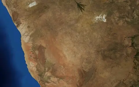

Desert, sandveld, and basin
“Kalahari Desert” is the established English name; Botswana's national atlas uses Kgalagadi desert and also classifies much of the same country-scale surface as Sandveld, the sandy counterpart to exposed-rock Hardveld.[2] This page uses Kalahari for the physical dryland concentrated in southwestern and central Botswana, adjoining eastern Namibia, and the Northern Cape of South Africa. Political borders cross the landscape but do not form its natural margins.
The larger Kalahari Basin and its sand cover continue north through wetter savanna and woodland in Angola, Zambia, Zimbabwe, and toward the Democratic Republic of the Congo. A 2022 basin synthesis maps the interior sand sea over more than 2.5 million km² and traces the sedimentary basin roughly 2,200 km from the Congo region to South Africa.[3] Those figures explain the scale of the geological system; they are not an area or length for the climatic desert. This page omits conventional desert-area estimates that lack a reproducible boundary or measurement method.
A plateau interior with graded margins
The Kalahari occupies the high continental interior between Atlantic-draining uplands in Namibia and the eastern plateau rim of Botswana and South Africa. The wider basin averages about 1,200 m above sea level, while the Government of Botswana describes its sand-filled interior at about 1,100 m.[1][3] These are regional means, not a highest point or a uniform basin-floor elevation.
Relief changes slowly across broad plains. In the South African portion of Kgalagadi Transfrontier Park, for example, mapped topography rises from about 870 m in the south to 1,090 m in the north—a 220 m change over roughly 200 km.[5] In central Botswana near Letlhakeng, a Department of Water Affairs study measured terrain mostly at 1,100–1,190 m and gradients below 2.5 m/km toward the basin interior; fossil valleys locally cut 20–30 m below the plain.[4] These local transects illustrate the subdued relief without pretending to define the entire desert.
Westward, the inland Kalahari remains distinct from the coastal Namib Desert, whose aridity is tightly linked to the cold Benguela Current. Northward, the Kalahari sand continues beyond the driest climate into the Okavango wetlands and wooded northern basin. Eastward, the Kalahari–Zimbabwe Upwarp forms a broad divide between internal drainage and tributaries that run through the Limpopo system toward the Indian Ocean.[3][4]
Sand sheets, fixed dunes, pans, and valleys
The familiar red surface is not one uninterrupted layer of loose windblown sand. Basin fill includes basal gravels and conglomerates, sandstone, clay, calcrete, silcrete, and unconsolidated sand; the combined Kalahari Group reaches as much as 450 m in the deepest parts of the wider basin.[3] That maximum is a sediment thickness inferred from basin geology, not the height of a dune or the depth of sand everywhere.
Most dune ridges are now held by grass, shrubs, or woodland. A 2022 synthesis finds that modern rainfall, vegetation, and generally insufficient wind energy suppress widespread sand transport, although dune crests can still move episodically in the western and southern Kalahari.[3] A separately mapped field of vegetated linear dunes covers about 100,000 km² from approximately 23°S in Namibia to 28°S in South Africa and eastward into Botswana; measured ridges there reach about 20 m.[7] These dimensions apply to that southwest dune field, not to all Kalahari sand.
Mostly relict forms
Linear dunes preserve repeated phases of aeolian accumulation; present-day mobility is usually limited to exposed crests and disturbed surfaces.
Temporary terminal lows
Shallow clay-, salt-, or duricrust-lined depressions collect local runoff, then lose water by evaporation and infiltration.
Dry drainage lines
Botswana uses this name for fossil valleys that rarely carry more than short local flows under the present climate.[4]
A recycled fluvial–aeolian sediment system
The Kalahari is an intracratonic sag basin—a broad depression within old continental crust—not a tectonic trench with one sharp rim. Its long development followed the breakup of Gondwana and later uplift of southern Africa's margins. Rivers deposited gravel, clay, and sand in interior lows; dry phases allowed wind to rework exposed sediment; and repeated wetting, evaporation, and groundwater movement cemented parts of the fill into calcrete (calcium-carbonate duricrust) and silcrete (silica-cemented duricrust).[3]
Mineral evidence rules out a single modern source for the red sand. Analysis of 100 aeolian and river samples across the basin found northern and central dune sand dominated by monocrystalline quartz and durable heavy minerals. Its composition records strong pre-weathering followed by repeated river and wind recycling, while sand near the western and eastern margins contains more locally supplied material from exposed basement rocks.[3] Colour alone therefore does not map one depositional event or one source region.
Dune ages are equally composite. Compiled luminescence dates record multiple accumulation phases within each dunefield over roughly the last 190,000 years; they do not support a single desert-wide episode of dune construction.[3] The present fixed ridges are inherited landforms that may be reworked at the surface rather than freshly advancing dunes.
Several catchments, not one closed bowl
The Kalahari does not have one source, mouth, or outlet. Much of central and northern Botswana is endorheic: runoff terminates inland. The Okavango arrives from humid Angolan headwaters, spreads across its alluvial fan, and loses most water through evapotranspiration and infiltration; reduced floodwater can continue through the Boteti toward the Makgadikgadi depression.[3][8] The delta is consequently part of the northern basin's hydrology, not evidence that the whole Kalahari has permanent surface drainage.
Makgadikgadi is a distinct terminal sub-basin. Modern Sua and Ntwetwe pans occupy parts of a former lake system and receive seasonal local runoff, ephemeral rivers from the east and northeast, and occasional Boteti inflow from the southwest. The pan floors lie near 903–916 m at measured study sites and receive about 300 mm of summer rain annually; seasonal flooding, water-table change, evaporation, and wind then alternate clay and evaporite deposition with deflation.[9] Older shorelines at several elevations record much larger lakes, but no single “Lake Makgadikgadi” area is used here because published reconstructions refer to different stands and models.
Drainage differs again in the south. The Nossob joins the Molopo, while the Auob and other channels flow only after exceptional rain and commonly lose water along sandy beds. To the east of the Kalahari–Zimbabwe Upwarp, Botswana tributaries of the Limpopo drain toward the Indian Ocean.[3][4] The named desert therefore crosses internal catchments, fossil drainage, and outward-draining margins.
Summer rain across a steep gradient
Continental position, subtropical high pressure, and moisture transport from the Indian Ocean help create an east-to-west drying trend, while rainfall generally increases northward. Most rain falls as warm-season convection. In southern Botswana, frost can occur on winter nights even though summer maxima can exceed 40°C, so “hot desert” is too simple a label for the annual temperature regime.[1][3]
A four-station Botswana transect calculated from 1971–2000 meteorological records measured mean annual precipitation from 180 mm at the dry southern end to about 550 mm in the north. The same study found more than 90% sand through the upper 1.2 m of soil at all sites and groundwater roughly 25 m deep at wet Shakawe versus about 100 m at dry Bokspits.[6] These are station and field-site measurements, not desert-wide limits, but they show why brief rain can infiltrate without building a connected surface-water network.
Conditions also vary sharply from year to year. In Kgalagadi Transfrontier Park, the 2016–2026 management plan reports a southwest-to-northeast mean annual rainfall range of 120–350 mm, but individual yearly totals at a locality can fall below 100 mm or exceed 450 mm.[5] Temporary greening after storms is therefore compatible with persistent hydrologic aridity: vegetation responds quickly, while pans dry, dunes remain mostly fixed, and perennial rivers remain absent from most of the core.
Related drylands without merged boundaries
Within the Desert Hub, the Kalahari is a plateau-interior sandveld whose semi-arid climate and mostly fixed dunes contrast with the hyper-arid coastal Namib. The two approach one another in Namibia but remain different physical systems. Likewise, the Okavango Delta and Makgadikgadi Pans are hydrologic components of the northern Kalahari Basin, not synonyms for the Kalahari Desert.
The most dependable comparison is therefore by scope: climatic desert, geomorphic sand sea, geological basin, drainage catchment, and administrative district must be mapped separately. Coordinates for a park, pan, borehole, or research station locate that measured unit; none is presented as a centroid for the gradational transnational desert.
Sources and measurement notes
- Government of Botswana, “About Our Country” (accessed 29 August 2026). Source for Botswana's approximately 1,100 m sand-basin elevation, semi-arid climate, summer rainfall season, and winter frost context.
- Republic of Botswana, Department of Surveys and Mapping, “Geography of Botswana; Geology and Geomorphology; Weather and Climate”, Botswana National Atlas web edition (accessed 29 August 2026). Source for the Sandveld/Hardveld distinction, Kgalagadi terminology, sandy-soil coverage, semi-arid classification, and November–March rainfall season.
- Garzanti, E. et al., “Provenance of Kalahari Sand: Paleoweathering and recycling in a linked fluvial-aeolian system”, Earth-Science Reviews 224, 103867 (2022), doi:10.1016/j.earscirev.2021.103867. Source for the distinction between basin and dryland, more than 2.5 million km² sand-sea extent, approximately 2,200 km basin length, average 1,200 m plateau elevation, up-to-450 m sediment fill, sand mineralogy, multiple dune phases, climate controls, and regional river relationships.
- Republic of Botswana, Department of Water Affairs, Botlhapatlou Groundwater Exploration and Wellfield Development Project: Final Report (April 2012). Source for measured central Kalahari gradients and elevations, 20–30 m fossil-valley incision, pan behavior, mekgacha terminology, Kalahari–Zimbabwe drainage divide, and Kalahari Group lithology. Measurements describe the approximately 8,500 km² project area, not the whole desert.
- South African National Parks, Kalahari Gemsbok National Park Management Plan 2016–2026 (approved 27 May 2016; accessed 29 August 2026). Source for the park-scale 870–1,090 m elevation transect, 220 m change over 200 km, 120–350 mm southwest-to-northeast mean rainfall range, and sub-100 to above-450 mm annual variability. These values are not generalized to the entire Kalahari.
- Bhattachan, A. et al., “Evaluating Ecohydrological Theories of Woody Root Distribution in the Kalahari”, PLoS ONE 7(3), e33996 (2012), doi:10.1371/journal.pone.0033996. Source for the 1971–2000 Botswana Bureau of Meteorology station basis, 180–550 mm/year transect, greater-than-90% sand in the sampled upper 1.2 m, and approximately 25–100 m site water-table depths.
- Stone, A. et al., “Reconstructing rainfall using dryland dunes: Assessing the suitability of the southern Kalahari for unsaturated zone hydrostratigraphies”, Frontiers in Earth Science 10, 1034671 (2022), doi:10.3389/feart.2022.1034671. Source for the approximately 100,000 km² southwest vegetated-linear-dune field, its 23°S–28°S span, approximately 20 m ridge height, and eastward sediment thickness near 150 m.
- Government of Botswana, Department of National Museum and Monuments, Okavango Delta Management Plan 2021–2028 (final plan, July 2021; hosted by the UNESCO World Heritage Centre). Source for the delta's fluvially reworked Kalahari sands, fossil dune-interdune systems, lacustrine deposits, and variable flood propagation within the northern basin.
- Franchi, F. et al., “Late Pleistocene–Holocene Palaeoenvironmental Evolution of the Makgadikgadi Basin, Central Kalahari, Botswana”, Frontiers in Ecology and Evolution 10, 818417 (2022), doi:10.3389/fevo.2022.818417. Source for the Makgadikgadi sub-basin setting, 50–300 m Kalahari Group succession there, modern inflow directions, approximately 300 mm/year summer rainfall, measured 903–916 m pan-floor elevations, and alternating flood, evaporite, clay, and wind processes.